
Keraunos · @KeraunosObs
20 followers · 221 posts · Server techhub.social🔁 UW-Madison CIMSS (@UWCIMSS)
6 hours of 1-minute Mesoscale Sector @NOAASatellites #GOES16/#GOESeast Infrared images showed Hurricane #Lee reaching Category 5 intensity by 0300 UTC on 08 September: https://cimss.ssec.wisc.edu/satellite-blog/images/2023/09/230907_goes16_infared_Hurricane_Lee_Cat5_anim.gif
🐦🔗 https://twitter.com/UWCIMSS/status/1699986676574036442
🕐 08/09 05:23

NWS Miami (bot) · @nwsmiami_bot
34 followers · 4568 posts · Server lawfedi.blueRT @NOAASatellitePA: SATELLITE SPOTLIGHT: @NOAA's #GOES16 🛰️ caught the frequent #lightning associated with Hurricane #Idalia as it made landfall near Keaton Beach, Florida this morning. Get the latest: https://t.co/B0vYuIVeYh #FLwx https://t.co/kUObsTelrr
#goes16 #lightning #idalia #flwx

JBouchez · @jbouchez
223 followers · 773 posts · Server mstdn.socialUne belle spirale dépressionnaire centrée sur la Baie d'Hudson.
#GOES16 #satellite
NWS State College (bot) · @nwsstatecollege_bot
26 followers · 206 posts · Server m.ai6yr.org
Visible #satellite pic from #GOES16 showing snow across northern #PAwx from last night

Colin Sullender · @shiruken
159 followers · 890 posts · Server octodon.socialSatellite imagery from NOAA's GOES-16 reveals the smoke plume from the controlled burn on the evening of February 6, 2023 at approximately 4:45PM EST (21:45 UTC).
Source: https://col.st/B5Mpo
#Ohio #Train #Toxic #Burn #Chemical #Plume #Smoke #Satellite #NOAA #GOES16 #GOESEast
#ohio #train #toxic #burn #chemical #plume #smoke #satellite #noaa #goes16 #goeseast
YouStorm · @youstorm
102 followers · 612 posts · Server mastodon.social
Disruption toots · @cont
11 followers · 1243 posts · Server social.vivaldi.netAfternoon #GOES16 satellite showing the period of sunny skies across the area. Clouds were last to exit the Fox Valley and far northeast WI (along with over Lake Michigan). Mid-high clouds continue to stream in from the west providing for more filtered sunshine. #wiwx https://t.co/zoPkm9lIJQ #SMEM

Okla.Social · @OklaBot
28 followers · 500 posts · Server okla.socialUWCIMSS: True Color RGB images from @NOAASatellites #GOES16/#GOESeast showed plumes of blowing dust being lofted by strong winds across New Mexico, Texas, Oklahoma and Kansas: #NMwx #TXwx #OKwx #KSwx https://twitter.com/UWCIMSS/status/1613292722521255938
#goes16 #nmwx #txwx #okwx #kswx
YouStorm · @youstorm
102 followers · 612 posts · Server mastodon.social
Wotan, from Texas · @wotantx
15 followers · 221 posts · Server mastodon.sdf.orgRT @CIMSS_Satellite@twitter.com
True Color RGB images from @NOAASatellites@twitter.com #GOES16/#GOESeast are showing areas of blowing dust across parts of West Texas, due to high winds behind a cold front gusting in excess of 60 mph: https://geosphere.ssec.wisc.edu/#playing:true;coordinate:-2307717,3263830;zoom:6.1;coverage:radc;num_frames:52;frame_rate:20;start_time:2023-01-02T19:00:00Z;timeframe:Start%20Time; #TXwx @NWSMidland@twitter.com
🐦🔗: https://twitter.com/CIMSS_Satellite/status/1610055680337084418

don Elías (como los buses) 🥨 · @donelias
296 followers · 850 posts · Server mastodon.cr¡Ahí viene el 2023 hacia el continente americano!
#goes16 #caribe #satelites #anonuevo #satelliteimages
YouStorm · @youstorm
93 followers · 577 posts · Server mastodon.socialLarge #wildfire 🔥 near Santiago, #Chile 🇨🇱 during ongoing heatwave with #pyrocumulus (indicated by white clouds above the smoke plume) activity on both 14 and 15 December as seen by #GOES16 🛰️ #IncendioForestal
#wildfire #chile #pyrocumulus #goes16 #incendioforestal
YouStorm · @youstorm
102 followers · 612 posts · Server mastodon.socialLarge #wildfire 🔥 near Santiago, #Chile 🇨🇱 during ongoing heatwave with #pyrocumulus (indicated by white clouds above the smoke plume) activity on both 14 and 15 December as seen by #GOES16 🛰️ #IncendioForestal
#wildfire #chile #pyrocumulus #goes16 #incendioforestal

Torsten · @DE2TRF
54 followers · 80 posts · Server mastodon.radioHere’s a GIF that I did of the GOES satellite showing the solar eclipse this morning.
#ecplise #solareclipse #GOES #GOES16 #solareclipse2020
#SolarEclipse2020 #goes16 #goes #solareclipse #ecplise

capitalweather · @capitalweather
1224 followers · 234 posts · Server mstdn.socialRT @NOAASatellitePA@twitter.com
#SATELLITE SPOTLIGHT: @NOAA@twitter.com's #GOES16🛰️ is closely watching the clouds and #lightning associated with a powerful winter storm pushing its way across the central U.S. today. Everything from #Blizzard Warnings to #Tornado Watches are in effect. Latest: http://weather.gov
🐦🔗: https://twitter.com/NOAASatellitePA/status/1602771535357526016
#tornado #blizzard #lightning #goes16 #satellite

Jared Smith · @jaredwsmith
244 followers · 280 posts · Server mastodon.onlineChanges to GOES-16 satellite data distribution over NOAAPort/SBN today. I think I'm okay with losing true full-disk data in exchange for higher-resolution data in the Northern Hemisphere in AWIPS. https://cimss.ssec.wisc.edu/satellite-blog/archives/48952
#awips #wxmastodon #weather #weatherdata #goeseast #goes16 #goesr
#goesr #goes16 #goeseast #WeatherData #Weather #wxmastodon #awips

🇺🇸 Bewickwren 🇵🇹 · @Bewickwren
324 followers · 2408 posts · Server toot.communityAfter 1800 UTC on 01 December 2022, changes were made to Full Disk #GOES16 (GOES-East) #imagery that is broadcast via the #Satellite Broadcast Network (SBN) for #AWIPS users (see the bottom section of this TOWR-S Communications).
One change was the increase in spatial resolution of the “Clean” Infrared Window (10.3 µm) from 6 km to the native 2 km (at satellite nadir).
#goes16 #imagery #satellite #awips
Jared Smith · @jaredwsmith
244 followers · 280 posts · Server mastodon.online
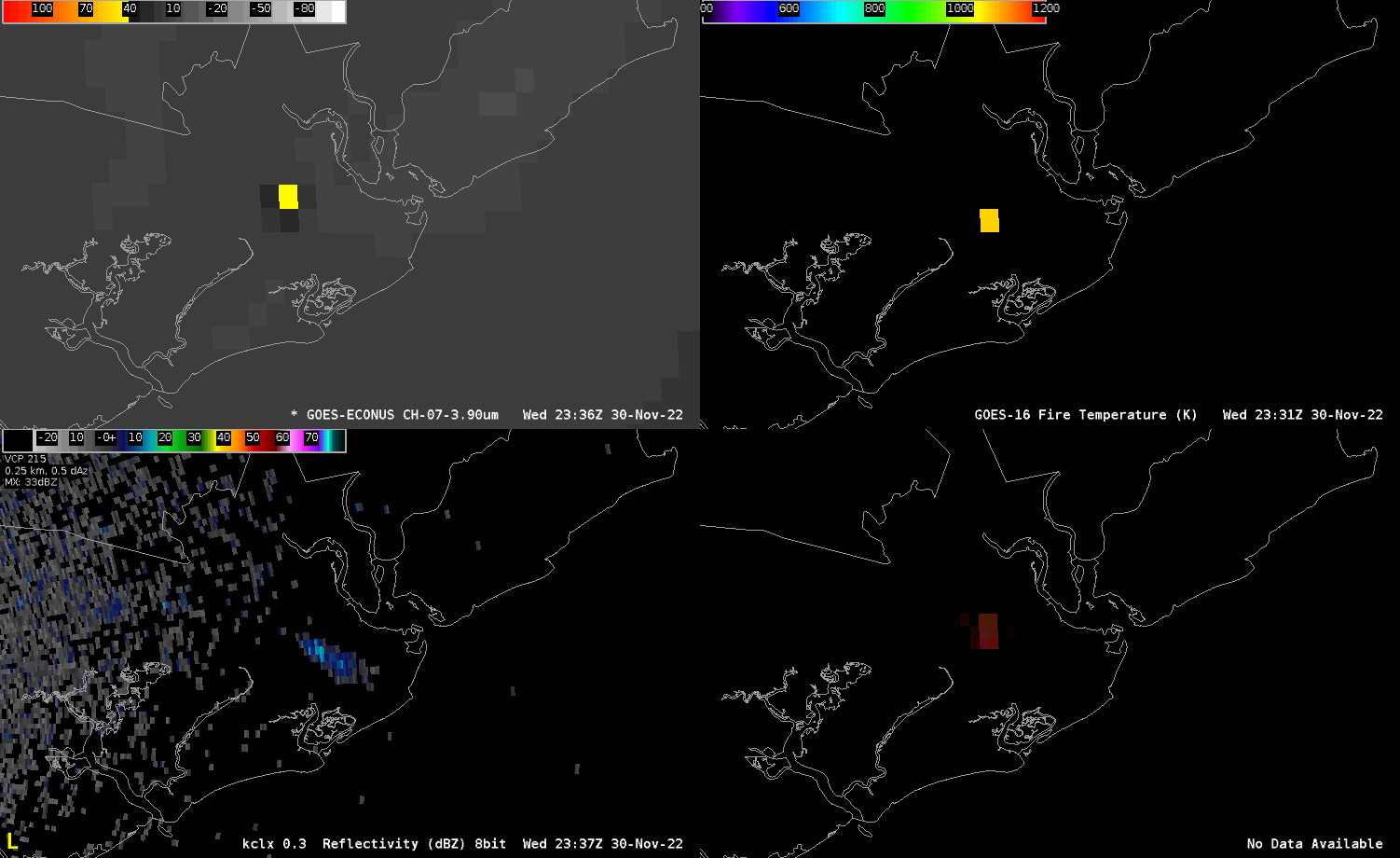
The fire was also hot enough for detection from the GOES-East satellite. Clockwise from top left: 3.9um shortwave infrared, Fire Temperature derived product, Fire Temp RGB, and radar reflectivity showing the smoke plume. The Fire Temp derived product detected temperatures as high as 1300°F. #wxmastodon #fire #remotesensing #goes16 #awips
#awips #goes16 #RemoteSensing #fire #wxmastodon
YouStorm · @youstorm
79 followers · 556 posts · Server mastodon.socialLenticular clouds stuck over Lake Buenos Aires🇦🇷 in the lee of the Patagonian Andes, lasting through the day, 25 November as seen by #GOES16🛰️
YouStorm · @youstorm
102 followers · 612 posts · Server mastodon.socialLenticular clouds stuck over Lake Buenos Aires🇦🇷 in the lee of the Patagonian Andes, lasting through the day, 25 November as seen by #GOES16🛰️