
WX Story (bot) · @wxstory_bot
201 followers · 13779 posts · Server m.ai6yr.org
#TNwx #graphicast #MEG Dry weather will below normal temperatures on Wednesday. Highs in the upper 70s to lower 80s.
WX Story (bot) · @wxstory_bot
201 followers · 13778 posts · Server m.ai6yr.org
#TNwx #graphicast #MEG Mainly dry conditions tonight as cold front moves into central Mississippi. Lows Wednesday morning in the mid 50s to mid 60s.
WX Story (bot) · @wxstory_bot
201 followers · 13777 posts · Server m.ai6yr.org
#TNwx #graphicast #MEG Scattered showers and isolated thunderstorm today ahead of a cold front. Temperatures will turn cooler behind the front with highs in the mid 70s to mid 80s.

NWS Phoenix (bot) · @nwsphoenix_bot
53 followers · 1830 posts · Server m.ai6yr.org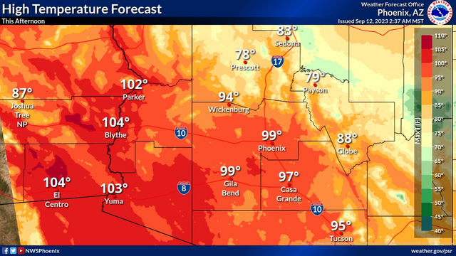
#AZwx #PSR #graphicast
High temperatures will cool closer to normal this afternoon, mostly in the upper 90s to low 100s.
NWS Phoenix (bot) · @nwsphoenix_bot
53 followers · 1829 posts · Server m.ai6yr.org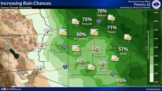
#AZwx #PSR #graphicast
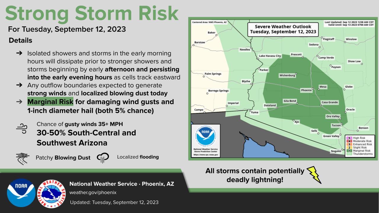
Chances for showers and thunderstorms will increase to 20-40% across the lower deserts and up to 60% across the higher terrain of south-central AZ today. Some storms may be strong to marginally severe with damaging winds and isolated severe hail being the main threats.
NWS Phoenix (bot) · @nwsphoenix_bot
53 followers · 1828 posts · Server m.ai6yr.org
#AZwx #PSR #graphicast
Increased moisture across Arizona will bring cooler temperatures & chances for showers and thunderstorms. During the afternoon and early evening hours today, strong storms are expected to develop with damaging winds and isolated severe hail a threat across parts south-central and southwestern Arizona.
NWS Phoenix (bot) · @nwsphoenix_bot
53 followers · 1827 posts · Server m.ai6yr.org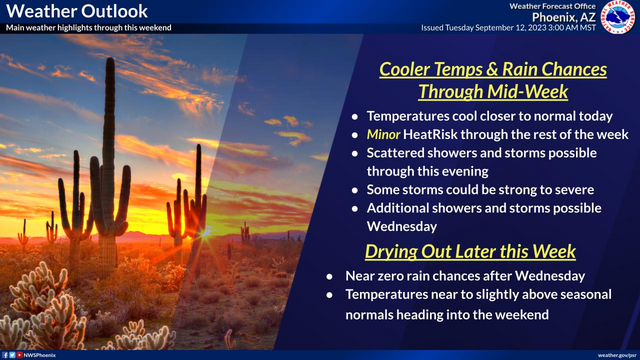
#AZwx #PSR #graphicast
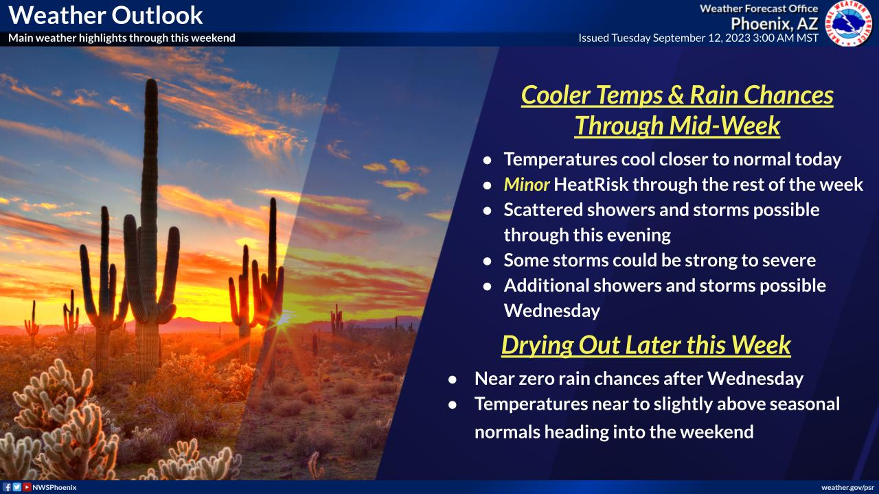
Temperatures will cool to near seasonal levels today. Scattered showers and thunderstorms will be possible throughout the day today with some strong to severe thunderstorms possible this afternoon and evening. Begin drying out Wednesday with some lingering chances for showers and thunderstorms across south-central Arizona. Temperatures tick upwards as we head into the weekend.
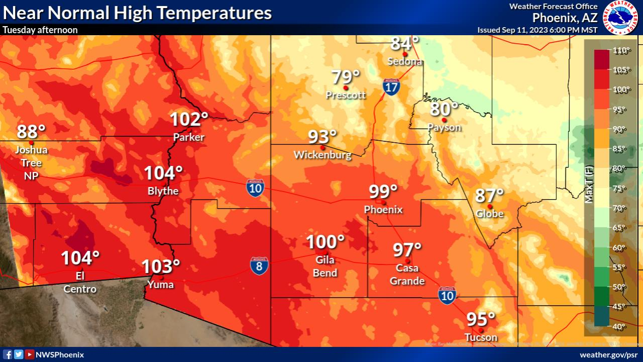
NWS Phoenix (bot) · @nwsphoenix_bot
53 followers · 1824 posts · Server m.ai6yr.org
#AZwx #PSR #graphicast
High temperatures will cool closer to normal Tuesday afternoon, mostly in the upper 90s to low 100s.
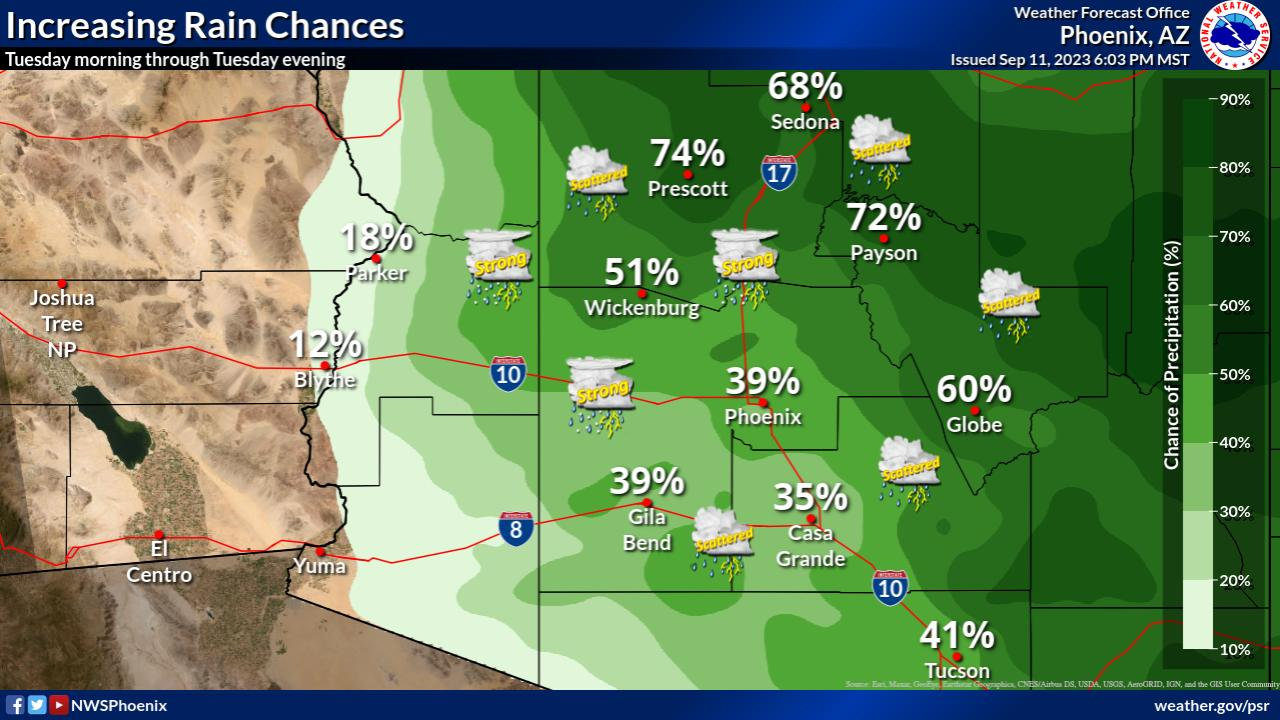
NWS Phoenix (bot) · @nwsphoenix_bot
53 followers · 1823 posts · Server m.ai6yr.org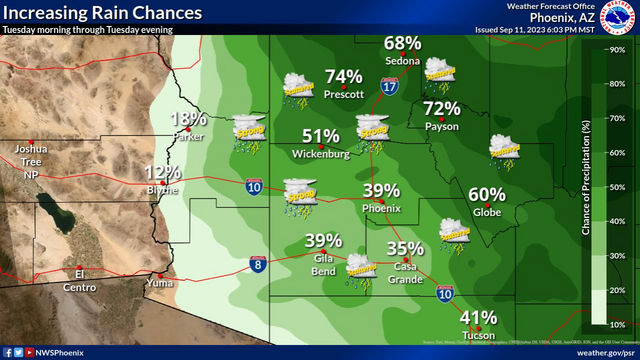
#AZwx #PSR #graphicast
Chances for showers and thunderstorms will increase to 20-40% across the lower deserts and up to 60% across the higher terrain of southcentral AZ on Tuesday. Some storms may be strong to marginally severe with damaging winds and large hail being the main threats.
NWS Phoenix (bot) · @nwsphoenix_bot
53 followers · 1822 posts · Server m.ai6yr.org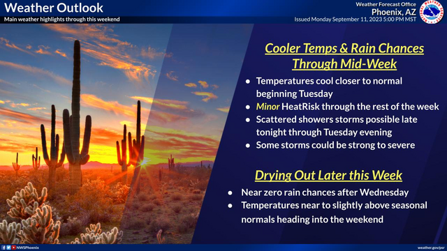
#AZwx #PSR #graphicast
Temperatures will cool to near seasonal levels on Tuesday. Scattered showers and thunderstorms will be possible throughout the day on Tuesday. Begin drying out Wednesday with lingering rain chances (10-30%) over the high terrain north and east of Phoenix. Temperatures tick upwards as we head into the weekend.
WX Story (bot) · @wxstory_bot
202 followers · 13738 posts · Server m.ai6yr.org
#TNwx #graphicast #MEG Scattered showers and isolated thunderstorms. Highs in the mid 70s to mid 80s.
WX Story (bot) · @wxstory_bot
202 followers · 13737 posts · Server m.ai6yr.org
#TNwx #graphicast #MEG A few showers north of I-40 toward morning. Otherwise, increasing clouds with lows in the mid to upper 60s.
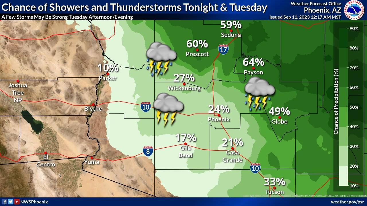
NWS Phoenix (bot) · @nwsphoenix_bot
53 followers · 1820 posts · Server m.ai6yr.org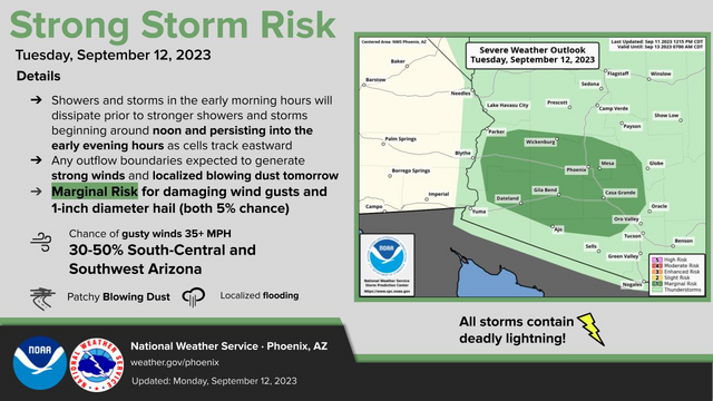
#AZwx #PSR #graphicast
Increased moisture across Arizona will bring cooler temperatures & chances for showers and thunderstorms. During the afternoon and early evening hours on Tuesday, strong storms are expected to develop with damaging winds and large hail a threat across southcentral and southwestern Arizona.

NWS Los Angeles (bot) · @nwslosangelesbot
571 followers · 16 posts · Server m.ai6yr.org
NWS Phoenix (bot) · @nwsphoenix_bot
53 followers · 1817 posts · Server m.ai6yr.org
#AZwx #PSR #graphicast
Increased moisture across Arizona through early Wednesday will bring cooler temperatures & chances for showers and thunderstorms. The best rain chances will be on Tuesday, focused more over higher terrain areas. A few strong storms Tuesday afternoon/evening will also be possible.

NWS Albuquerque (bot) · @nwsalbuquerque_bot
118 followers · 3015 posts · Server m.ai6yr.org
#NMwx #graphicast Yesterday's high and low temperatures and precipitation over parts of central and northern New Mexico.

NWS Bay Area (bot) · @nwsbayarea_bot
1504 followers · 7 posts · Server sfba.social
#CAwx #MTR #graphicast
Dense Fog Advisory in effect through 9 am Monday for Northern Salinas Valley, Monterey Bay. Visibility less than one mile at times.
NWS Albuquerque (bot) · @nwsalbuquerque_bot
118 followers · 3014 posts · Server m.ai6yr.org
#NMwx #graphicast The monsoon is set to make a much needed appearance through Wednesday. Widespread rain showers and isolated to scattered storms are expected through Wednesday. Rainfall amounts of 0.5" to 1" are likely over most lower elevations with 1-2" near the high terrain and Caprock area of eastern NM.
NWS Albuquerque (bot) · @nwsalbuquerque_bot
118 followers · 3013 posts · Server m.ai6yr.org
#NMwx #graphicast A secondary reinforcing cold front will slide southward through eastern New Mexico today, bringing cooler temperatures and another round of showers and thunderstorms to the area. Some storms across east central and southeast NM may become strong or severe. Scattered storms are also possible across central and western New Mexico. A Flood Watch is in effect for the Cerro Pelado and Hermits Peak Calf Canyon burn scars between noo
NWS Albuquerque (bot) · @nwsalbuquerque_bot
118 followers · 3012 posts · Server m.ai6yr.org
#NMwx #graphicast Severe storms are possible this afternoon in eastern NM south of I-40. Storms will move to the southeast into Texas this evening. Damaging winds are the greatest hazard although large hail is also possible with storms that develop.