
Joseph Elfelt · @mappingsupport
536 followers · 474 posts · Server m.ai6yr.org
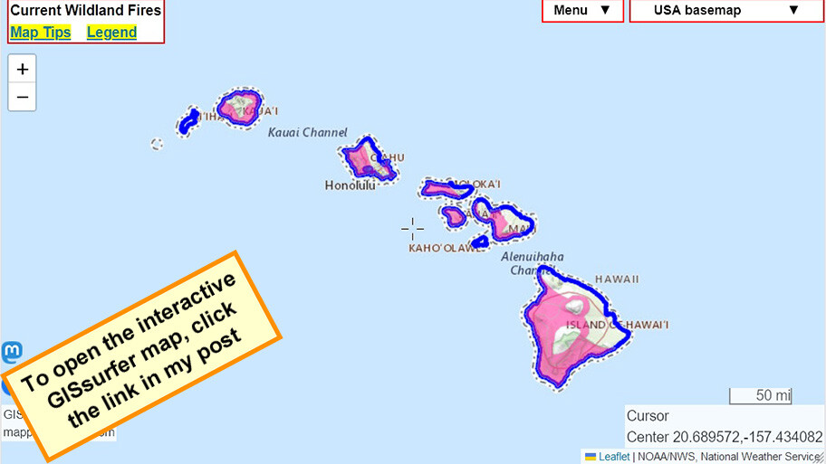
#RedFlagWarning for #Hawaii today.
For details - including timing - open the map, zoom in, click any red area, follow the link.
Click “Map tips” upper left corner for more info.
Open #GISsurfer map:
https://mappingsupport.com/p2/gissurfer.php?center=20.689572,-157.434082&zoom=7&basemap=USA_basemap&overlay=State_boundary,Red_flag_warning&data=https://mappingsupport.com/p2/special_maps/disaster/USA_wildland_fire.txt
#redflagwarning #hawaii #hifire #hiwx #gissurfer

Jan Philipp Albrecht · @JanAlbrecht
346 followers · 4063 posts · Server respublicae.euRT Laurie Garrett
Oh my god...
<div class="rsshub-quote">
The Hotshot Wake Up: Unreal moments in Lahaina, Hawaii on the island of Maui.
We cover this on todays episode, below.
#wildfire #hifire
</div>
🐦🔗: https://n.respublicae.eu/Laurie_Garrett/status/1689377175030439936
Joseph Elfelt · @mappingsupport
446 followers · 356 posts · Server m.ai6yr.org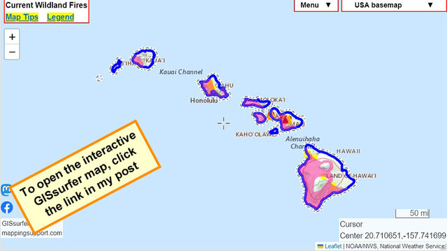
#RedFlagWarning for Hawaii extended until Thursday morning. For details open the interactive #GIS map, zoom in and click a red area.
Some areas have more than one type of weather warning. So when the popup appears you might need to scroll down to the section with the red flag warning - then follow the link for the details.
#HIfire #HIwx #MauiFire #WestMaui #Lahaina #Wildfire #Geospatial #Maps #Mapping #Leaflet #ArcGIS #WebMap
Open #GISsurfer map:
https://mappingsupport.com/p2/gissurfer.php?center=20.710651,-157.741699&zoom=7&basemap=USA_basemap&overlay=VIIRS_7_day,MODIS_7_day,State_boundary,Red_flag_warning&data=https://mappingsupport.com/p2/special_maps/disaster/USA_wildland_fire.txt
#redflagwarning #gis #hifire #hiwx #mauifire #westmaui #lahaina #Wildfire #geospatial #maps #mapping #leaflet #arcgis #webmap #gissurfer
Joseph Elfelt · @mappingsupport
444 followers · 351 posts · Server m.ai6yr.org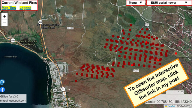
To read the ‘fire weather forecast’ for #Maui, open this interactive #GIS map, click on Maui and follow the link. Upper and lower part of map has different forecast zones. East to northeast wind with increasing gust speed.
The map has lots of fire related layers you can turn on/off. Click “Map tips” in the upper left corner for help.
#HIfire #HIwx #MauiFire #WestMaui #Lahaina #Geospatial #Maps #Mapping #Leaflet #ArcGIS #WebMap
Open #GISsurfer map:
https://mappingsupport.com/p2/gissurfer.php?center=20.788470,-156.423340&zoom=13&basemap=ESRI_aerial_newer&overlay=USA_roads,MODIS_7_day,VIIRS_7_day,NOAA_fire_weather_forecast&data=https://mappingsupport.com/p2/special_maps/disaster/USA_wildland_fire.txt
#maui #gis #hifire #hiwx #mauifire #westmaui #lahaina #geospatial #maps #mapping #leaflet #arcgis #webmap #gissurfer
Joseph Elfelt · @mappingsupport
444 followers · 351 posts · Server m.ai6yr.org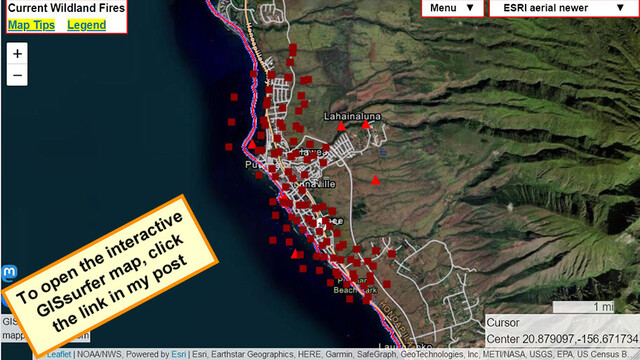
Interactive #GIS map always shows latest MODIS and VIIRS satellite heat detections for fires on #Maui including #LahainaFire and #UpcountryFire. Dark red is a detection within prior 6 hours.
Note the ‘false positive’ data - the ocean is not on fire.
#RedFlagWarning today.
To get the most benefit from the map see 2 links upper left corner.
#HIfire #HIwx #MauiFire #WestMaui #Lahaina #Geospatial #Maps #Mapping #Leaflet #ArcGIS #WebMap
Open #GISsurfer map:
https://mappingsupport.com/p2/gissurfer.php?center=20.878936,-156.678085&zoom=13&basemap=ESRI_aerial_newer&overlay=State_boundary,Forecast_discussion,USA_roads,MODIS_7_day,VIIRS_7_day&data=https://mappingsupport.com/p2/special_maps/disaster/USA_wildland_fire.txt
#gis #maui #lahainafire #upcountryfire #redflagwarning #hifire #hiwx #mauifire #westmaui #lahaina #geospatial #maps #mapping #leaflet #arcgis #webmap #gissurfer
Joseph Elfelt · @mappingsupport
444 followers · 345 posts · Server m.ai6yr.org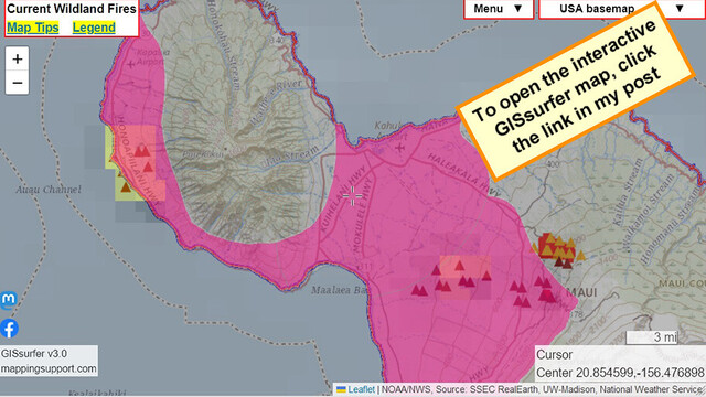
August 9 early morning. Interactive #GIS map for fires on #Maui including #LahainaFire and #UpcountryFire.
#RedFlagWarning today.
Map shows various satellite *heat* detections. This data is not real time, locations are only approximate and sometimes ‘false positive’.
To get the most benefit from the map see 2 links upper left corner.
#HIfire #HIwx #MauiFire #WestMaui #Lahaina #Geospatial #Maps #Mapping #Leaflet #ArcGIS #WebMap
Open #GISsurfer map:
https://mappingsupport.com/p2/gissurfer.php?center=20.854599,-156.476898&zoom=11&basemap=USA_basemap&overlay=VIIRS_7_day,MODIS_7_day,State_boundary,Forecast_discussion,GOES_west_fire_enhanced,Red_flag_warning&data=https://mappingsupport.com/p2/special_maps/disaster/USA_wildland_fire.txt
#gis #maui #lahainafire #upcountryfire #redflagwarning #hifire #hiwx #mauifire #westmaui #lahaina #geospatial #maps #mapping #leaflet #arcgis #webmap #gissurfer