
Kevin M. Gill · @kevinmgill
4426 followers · 431 posts · Server deepspace.social
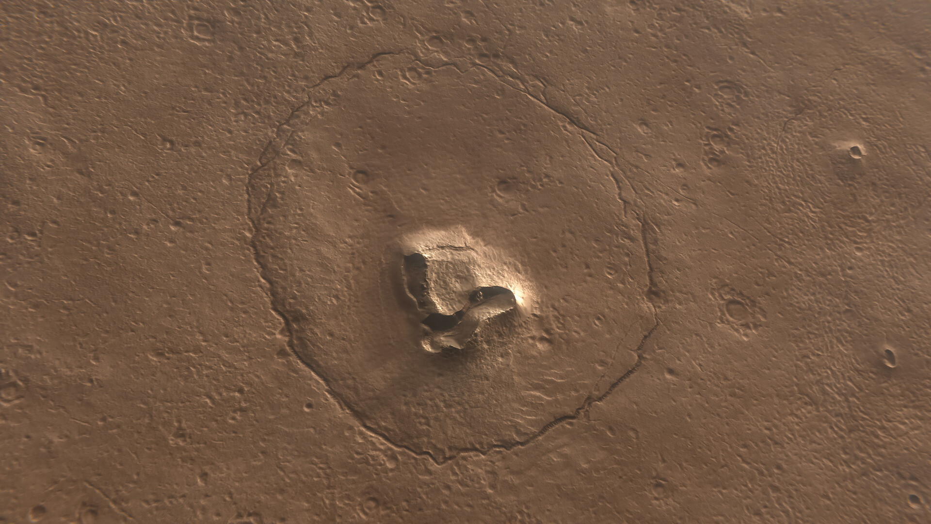
A Bear... On Mars?!
Rendered using HiRISE DTM data
NASA/JPL-Caltech/UArizona/Kevin M. Gill
https://flic.kr/p/2owz84r
https://flic.kr/p/2owtRNk
https://flic.kr/p/2owwQ5d

Hannah Celsius · @HannahCelsius
306 followers · 3322 posts · Server sunny.garden
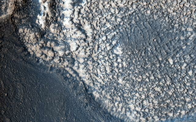
Two towers being build for the rich.
#Fensterfreitag #amsterdam #hirise #photography

GregCocks · @GregCocks
190 followers · 241 posts · Server techhub.social
New Interactive Mosaic Uses NASA Imagery To Show Mars In Vivid Detail
--
https://murray-lab.caltech.edu/CTX/V01/SceneView/MurrayLabCTXmosaic.html <-- The Global CTX Mosaic of Mars online interactive map
--
https://www.jpl.nasa.gov/news/new-interactive-mosaic-uses-nasa-imagery-to-show-mars-in-vivid-detail <-- JPL press release
--
[since I am on a spatial Mars ‘kick’…]
#GIS #spatial #mapping #Mars #remotesensing #water #science #highresolution #RedPlanet #spaceprobe #survey #map #topography #modeling #compsite #elevation #opendata #openaccess #ReconnaissanceOrbiter #MRO #ContextCamera #CTX #HiRISE #MARCI #GlobalSurveyor #global #image #interactive #online #map #water #fluvial #hydrology #geologic #tectonics #vulcanism #geomorphology #visualization #visualisation
#CalTech #JPL #NASA
#gis #spatial #mapping #Mars #remotesensing #water #science #highresolution #redplanet #spaceprobe #survey #map #topography #modeling #compsite #elevation #opendata #openaccess #reconnaissanceorbiter #mro #contextcamera #ctx #hirise #marci #globalsurveyor #global #image #interactive #online #fluvial #hydrology #geologic #tectonics #vulcanism #geomorphology #visualization #visualisation #caltech #JPL #NASA

ferrie = differentieel :mfrl: · @differentieel
45 followers · 458 posts · Server mastodon.frl
Voyage du Terre is een bijna vergeten melodie van Hans Jacobi voor een theater voorstelling die nimmer het levenslicht zag: Voyage du Terre er zou een voorstelling in het theater komen waar muziek bij moest – daar was de compositie […]
#Cello #Duduk #HandKlappen #HansJacobi #HiRISE #ModernClassical #MusicForADanceIII #percussie #ToyPiano #Trumpet #Ukulele #Violen #VoyageDuTerre
#cello #duduk #handklappen #hansjacobi #hirise #modernclassical #musicforadanceiii #percussie #toypiano #trumpet #ukulele #violen #voyageduterre
GregCocks · @GregCocks
190 followers · 238 posts · Server techhub.social
Sinuous Channels East Of Olympus Mons, Mars - Implications For Volcanic, Hydrological, And Tectonic Processes
--
https://doi.org/10.1016/j.icarus.2021.114798 <-- paper
-
"HIGHLIGHTS:
• [They] mapped channels and fossae within the volcanic plains east of Olympus Mons.
• Late Amazonian channels east of Olympus Mons formed by eruptions of lava or water.
• Fossae morphologies correspond to episodes of magmatic dike and sill emplacement.
• Loading of Olympus Mons may control magmatic ascent processes and eruption types..."
-
#GIS #spatial #mapping #volcanism #tectonics #Mars #surface #interior #geologicalprocesses #remotesensing #map #geology #extraterrestrial ##OlympusMons #volcanic #water #hydrology #hydrospatial #lava #fossae #morphology #geomorphology #magma #dike #sill #eruption #plains #traps #facies #map #survey #fluvial #bedrock #erosion #weathering #groundwater #surfacewater #regolith #lahar #meltwater #snow #ice #isostatic #HiRISE #CTX #imagery #chronostratigraphic #model #modeling #gischat
#gis #spatial #mapping #volcanism #tectonics #Mars #surface #interior #geologicalprocesses #remotesensing #map #geology #Extraterrestrial #olympusmons #volcanic #water #hydrology #hydrospatial #lava #fossae #Morphology #geomorphology #magma #dike #sill #eruption #plains #traps #facies #survey #fluvial #Bedrock #erosion #weathering #groundwater #surfacewater #regolith #lahar #meltwater #snow #ice #isostatic #hirise #ctx #imagery #chronostratigraphic #model #modeling #gischat

Astroland 🔭 · @astroland
555 followers · 1727 posts · Server mastodon.social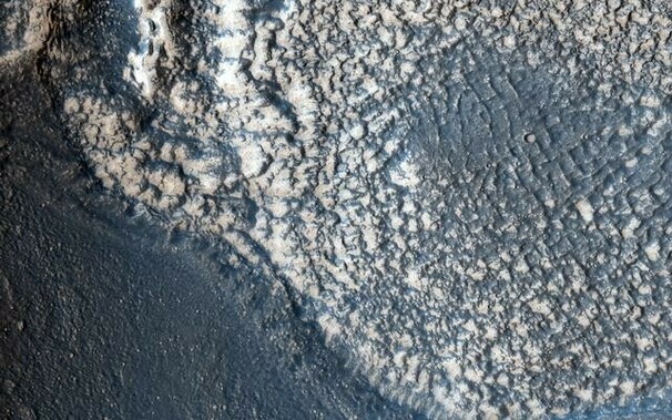
HiRISE Mars Foto van de dag: Embayment in Tectonized Fluvial Terrain. Credits: NASA/JPL-Caltech/Univ. of Arizona #mars #hirise #sterrenkunde #astronomie #nasa #ruimtevaart
#mars #hirise #sterrenkunde #astronomie #nasa #ruimtevaart
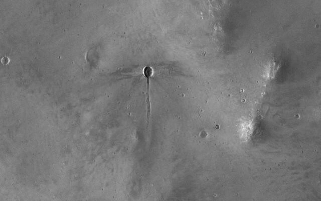
Astroland 🔭 · @astroland
555 followers · 1710 posts · Server mastodon.social
HiRISE Mars Foto van de dag: A Dragonfly-Shaped Crater. Credits: NASA/JPL-Caltech/Univ. of Arizona #mars #hirise #sterrenkunde #astronomie #nasa #ruimtevaart
#mars #hirise #sterrenkunde #astronomie #nasa #ruimtevaart

65dBnoise · @65dBnoise
1299 followers · 256 posts · Server mastodon.social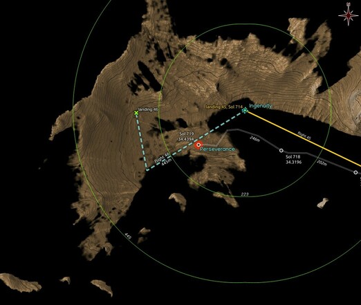
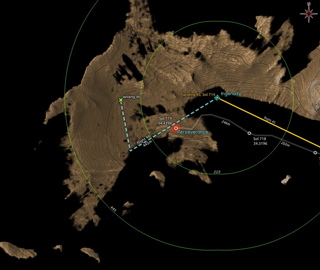
#Ingenuity should now be visible no matter where it landed after #Flight46, since most of the area for a possible landing is now visible from RMC 34.4394 where #Perseverance arrived after the Sol 719 drive.
Dashed flight path and 46th landing in cyan are wild guesses,
Map made using #QGIS with data from #NASA's #MMGIS and #HiRISE
#ingenuity #flight46 #perseverance #qgis #nasa #MMGIS #hirise #mars2020 #solarocks #space #visibility
65dBnoise · @65dBnoise
1299 followers · 256 posts · Server mastodon.social
#Ingenuity should now be visible no matter where it landed after #Flight46, since most of the area for a possible landing is now visible from RMC 34.4394 where #Perseverance arrived after the Sol 719 drive.
Dashed flight path and 46th landing in cyan are wild guesses,
Map made using #QGIS with data from #NASA's #MMGIS and #HiRISE
#ingenuity #flight46 #perseverance #qgis #nasa #MMGIS #hirise #mars2020 #solarocks #space #visibility
65dBnoise · @65dBnoise
1299 followers · 253 posts · Server mastodon.social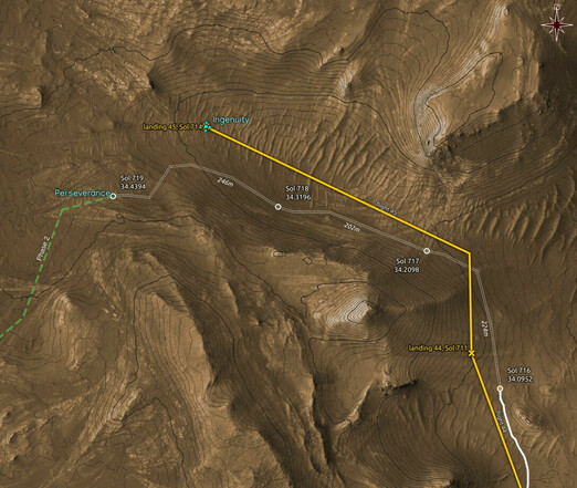
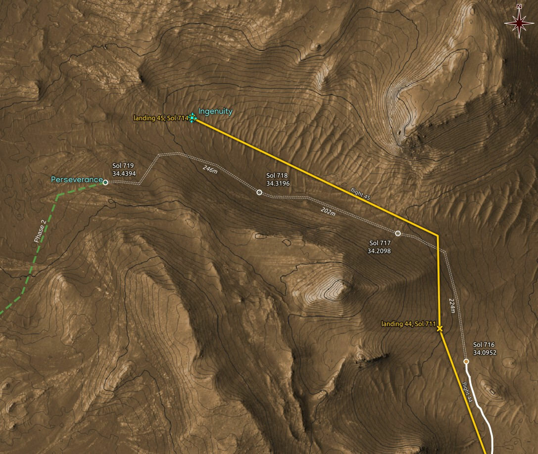
New location estimate for #Perseverance on Sol 719: RMC 34.4394. The white double dashed drive paths are guesses.
Map made using #QGIS with data from #NASA's #MMGIS and #HiRISE
#perseverance #qgis #nasa #MMGIS #hirise #mars2020 #solarocks #space #localization
65dBnoise · @65dBnoise
1299 followers · 253 posts · Server mastodon.social
New location estimate for #Perseverance on Sol 719: RMC 34.4394. The white double dashed drive paths are guesses.
Maps are made using #QGIS with data from #NASA's #MMGIS and #HiRISE
#perseverance #qgis #nasa #MMGIS #hirise #mars2020 #solarocks #space
Astroland 🔭 · @astroland
556 followers · 1694 posts · Server mastodon.social
HiRISE Mars Foto van de dag: Seasonal Flows in Valles Marineris. Credits: NASA/JPL-Caltech/Univ. of Arizona #mars #hirise #sterrenkunde #astronomie #nasa #ruimtevaart
#mars #hirise #sterrenkunde #astronomie #nasa #ruimtevaart
65dBnoise · @65dBnoise
1299 followers · 250 posts · Server mastodon.social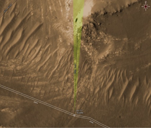
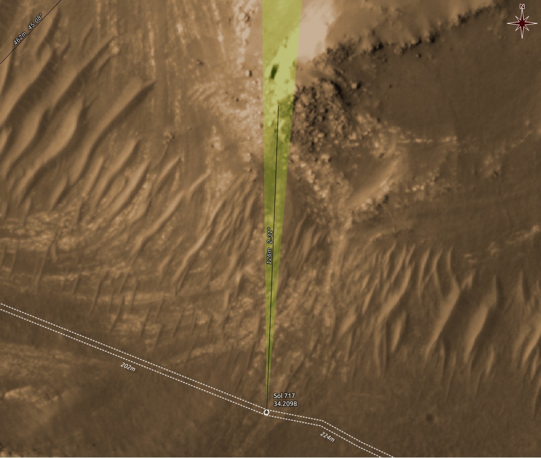
Context map showing the orientation and FOV of the MastcamZ camera when it captured the image above. The rocks are 125m away.
One more example why Sols are not good indicators of location. This is Sol 718, but the location is that of the end-of-drive of Sol 717.
Maps are made using #QGIS with data from #NASA's #MMGIS and #HiRISE
#qgis #nasa #MMGIS #hirise #perseverance #mars2020 #solarocks #space
65dBnoise · @65dBnoise
1299 followers · 246 posts · Server mastodon.social
65dBnoise · @65dBnoise
1299 followers · 244 posts · Server mastodon.social
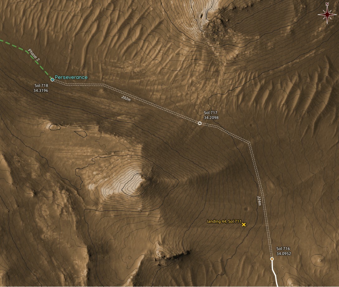
New location estimate for #Perseverance on Sol 718: RMC 34.3196. The estimate is based on single image metadata. The white double dashed paths are guesses.
Maps are made using #QGIS with data from #NASA's #MMGIS and #HiRISE
#perseverance #qgis #nasa #MMGIS #hirise #mars2020 #solarocks #space
65dBnoise · @65dBnoise
1298 followers · 237 posts · Server mastodon.social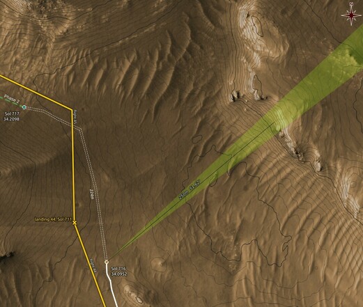
Astroland 🔭 · @astroland
553 followers · 1679 posts · Server mastodon.social
HiRISE Mars Foto van de dag: Possible Layers on Floor of Suzhi Crater. Credits: NASA/JPL-Caltech/Univ. of Arizona #mars #hirise #sterrenkunde #astronomie #nasa #ruimtevaart
#mars #hirise #sterrenkunde #astronomie #nasa #ruimtevaart
65dBnoise · @65dBnoise
1298 followers · 230 posts · Server mastodon.social
Map showing the orientation and FOV of #Perseverance's NAVCAM when the image above was captured.
#perseverance #qgis #MMGIS #hirise #mars2020 #nasa #solarocks #space
65dBnoise · @65dBnoise
1298 followers · 228 posts · Server mastodon.social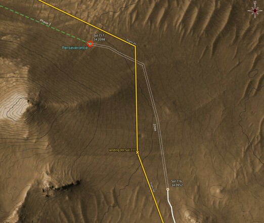
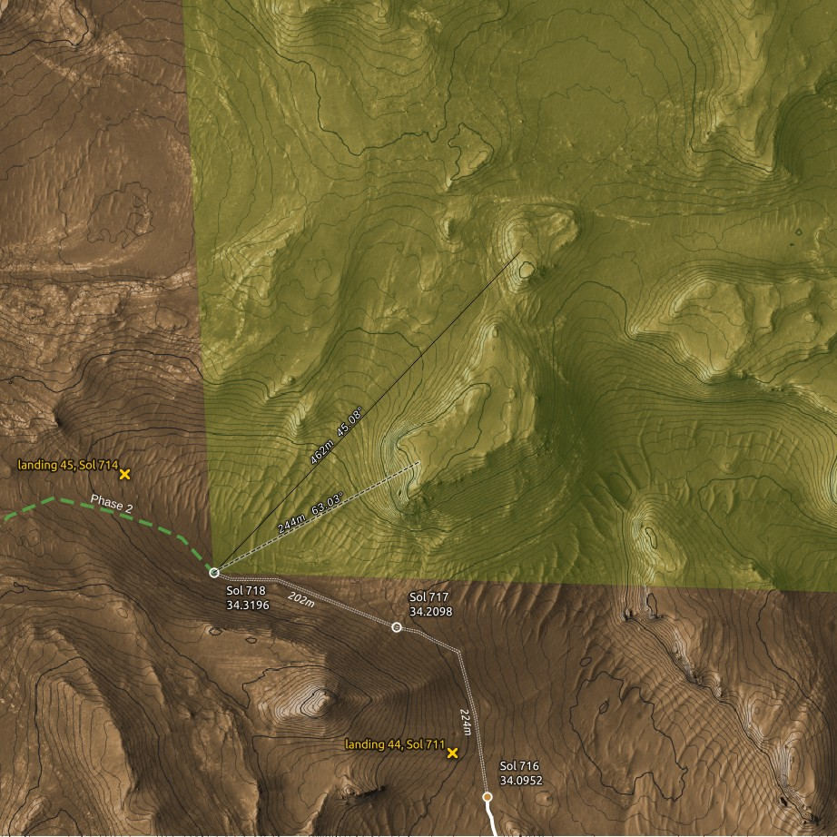
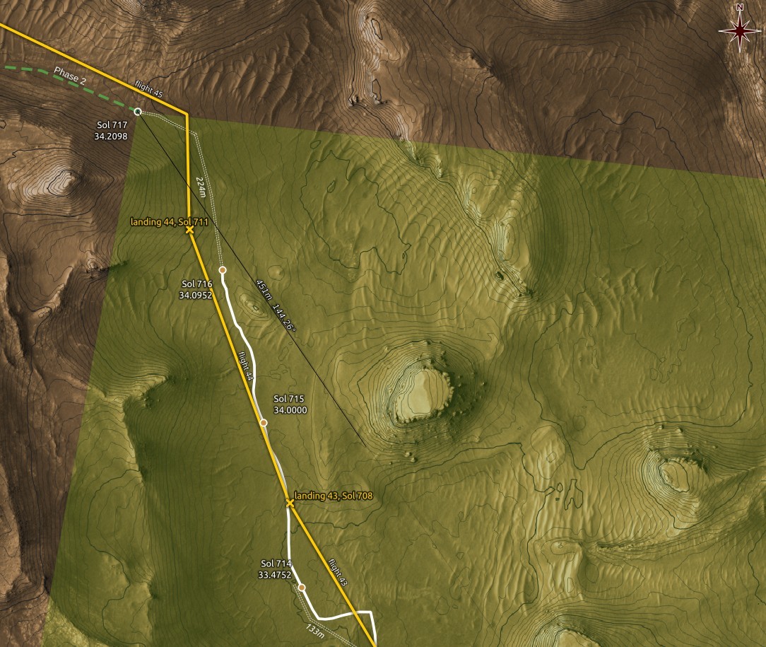
New location estimate for #Perseverance on Sol 717:
RMC 34.2098, ~220m NNW, around the foot of a 35m hill. #Ingenuity should be visible from this location.
Provisional estimate, based only on image metadata.
#perseverance #ingenuity #mars2020 #nasa #hirise #MMGIS #solarocks #space #qgis
65dBnoise · @65dBnoise
1298 followers · 228 posts · Server mastodon.social
New location estimate for #Perseverance on Sol 717:
RMC 34.2098, ~220m NNW, around the foot of a 35m hill. Provisional estimate, based only on image metadata.
#perseverance #mars2020 #nasa #hirise #MMGIS #solarocks #space #qgis