Andy @Revkin · @revkin
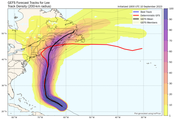
2078 followers · 1766 posts · Server mastodon.greenLatest model ensemble on #hurricanelee's final run toward Atlantic Canada and Maine. Irrational, of course, but I'm hating @ECMWF right now (the red track). Animation via Tomer Burg site of course: http://arctic.som.ou.edu/tburg/products/realtime/tropical/ensembles.php?storm=AL132023 More thoughts: https://twitter.com/Revkin/status/1701349598134935691
Sick Kid · @pariahsickkid
320 followers · 7138 posts · Server beige.party#hurricanelee is going to miss all the states and Bermuda, with the cone shrinking. It will still impact with tides and rip currents .
Zoom Earth · @zoom_earth
1838 followers · 1151 posts · Server mapstodon.spaceNight-time satellite imagery of Hurricane #Lee in the western Atlantic Ocean. Winds up to 115 mph, pressure 948 mb. #HurricaneLee #weather #WX
#lee #hurricanelee #weather #wx
azteclady · @herhandsmyhands
886 followers · 14355 posts · Server romancelandia.club#HurricaneLee looks to miss most of the usual U.S. targets, but the people of Bermuda are likely going to be hammered-again--and the people of New England and Nova Scotia as well.
AndThisIsMrsPeacock 🏳🌈 · @andthisismrspeacock
126 followers · 845 posts · Server mas.toAnother 24 have come and gone, #FediFam, they sure do fly by. Before we head back to sleep, it's time to think about THREE GOOD THINGS™️!
🕺#Datacenter move project is DONE!
🍬 My favorite #edibles are back in stock.
🌀 This #hurricane might not hit us after all!
Hope you all get some rest, wake up refreshed, and get ready to have a great day #tomorrow!
#ThreeGoodThings @3goodthings #gratitude #mindfulness #thankful #WX #HurricaneLee #SysAdmin #DatacenterLife
#datacenterlife #sysadmin #hurricanelee #wx #thankful #mindfulness #gratitude #ThreeGoodThings #tomorrow #hurricane #edibles #datacenter #FediFam
AI6YR · @ai6yr
4819 followers · 33403 posts · Server m.ai6yr.orgThe Eyewall: September 11, 2023 Outlook: Lee turns north this week, with an out to sea escape scenario becoming increasingly unlikely #Hurricane #Lee #HurricaneLee https://theeyewall.com/september-11-2023-outlook-lee-turns-north-this-week-with-an-out-to-sea-escape-scenario-becoming-increasingly-unlikely/
Zoom Earth · @zoom_earth
1832 followers · 1145 posts · Server mapstodon.spaceToday’s view of Category 3 Major Hurricane #Lee in the western Atlantic Ocean. Maximum wind speeds of 115 mph, pressure 948 mb. #HurricaneLee #weather #WX
#lee #hurricanelee #weather #wx
AI6YR · @ai6yr
4817 followers · 33382 posts · Server m.ai6yr.orgFrom @mattlanza on #HurricaneLee: "Still a long way to go here, but it would probably be sensible for folks in eastern New England and Nova Scotia/New Brunswick to begin assessing their preparedness situation should a significant storm come knocking." #hurricanes #MAwx #NovaScotia #NewBrunswick #NewEngland
#hurricanelee #hurricanes #mawx #novascotia #newbrunswick #newengland
AI6YR · @ai6yr
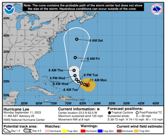
4816 followers · 33361 posts · Server m.ai6yr.orgLatest cone for #HurricaneLee #hurricane #lee https://www.nhc.noaa.gov/refresh/graphics_at3+shtml/024833.shtml?cone#contents
Zoom Earth · @zoom_earth
1827 followers · 1140 posts · Server mapstodon.spaceSunrise over Hurricane #Lee in the western Atlantic Ocean #HurricaneLee #weather #WX
#lee #hurricanelee #weather #wx
Sick Kid · @pariahsickkid
319 followers · 7061 posts · Server beige.partyZoom Earth · @zoom_earth
1824 followers · 1138 posts · Server mapstodon.spaceNight-time satellite imagery of Hurricane #Lee in the western Atlantic Ocean. Maximum winds over 120 mph, pressure 950 mb. #HurricaneLee #weather #WX
#lee #hurricanelee #weather #wx
WXFanatic · @WXFanatic
717 followers · 1505 posts · Server m.ai6yr.org👀
I'm watching you, Lee.
Source: http://arctic.som.ou.edu/tburg/products/realtime/tropical/?storm=AL132023
Goodnight y'all
Zoom Earth · @zoom_earth
1825 followers · 1135 posts · Server mapstodon.spaceThe sun sets on Hurricane #Lee north of the Leeward Islands #HurricaneLee #weather #WX
#lee #hurricanelee #weather #wx
WXFanatic · @WXFanatic
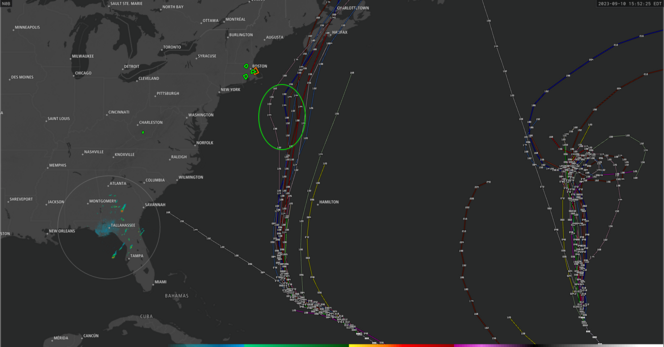
713 followers · 1494 posts · Server m.ai6yr.orgI'm noticing some of the models indicating a leftward shift with #HurricaneLee at 144+- hours out (I circled it in green) when parallel with Maryland/New Jersey.
Mind you this is going to change as that time nears and becomes more certain. A good rule of thumb is that anything more than 84 hours away or longer should be taken lightly.
With that said, when different models start showing a trend, it should be noted and watched for in future runs.
#hurricanelee #weather #wx #tropical #tropics
Joseph Elfelt · @mappingsupport
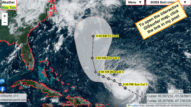
571 followers · 497 posts · Server m.ai6yr.orgEach time you open this interactive #GIS map you will see the latest view of #HurricaneLee from the GOES East satellite.
#Hurricane
Open #GISsurfer map:
https://mappingsupport.com/p2/gissurfer.php?center=28.207609,-67.236328&zoom=5&basemap=GOES_East_color&overlay=Country,Forecast_error_cone,Hurricane/Storm_observed_track,Hurricane/Storm_observed_position,Hurricane/Storm_forecast_track,Hurricane/Storm_forecast_position&data=https://mappingsupport.com/p2/special_maps/disaster/USA_weather.txt
#gis #hurricanelee #hurricane #gissurfer
AngryBeast · @angrybeast
254 followers · 398 posts · Server digitalcourage.socialAller Voraussicht nach befinden wir uns in einer sehr starken Hurricane-Season mit bereits 14 benannten Stürmen von Ariane bis Lee, davon 5 Hurricanes mit bisher 3 Cat 5-Hurricanes Franklin, Idalia und Lee.
Übrigens hat der abflauende Franklin uns diese noch anhaltende Omega-Lage beschert.
»Am 5. September lagen die Überreste von Franklin nördlich der Azoren und stabilisierten damit eine stationäre Omegalage in Europa, die zu katastrophalen Regenfällen in #Griechenland führte.«
https://en.wikipedia.org/wiki/2023_Atlantic_hurricane_season
AI6YR · @ai6yr
4808 followers · 33255 posts · Server m.ai6yr.org@theeyewallwx @mattlanza This is also useful (thanks Matt et al!): "Modeling shows this staying well east of North Carolina now, so from there south to Florida, this isn’t your storm. Bermuda? Still needs to watch closely. I would probably continue to watch this from Virginia to New Jersey, watching it fairly close from Long Island through Rhode Island, and watch it very close between Cape Cod and Newfoundland, including New Brunswick and Prince Edward Island. " #HurricaneLee
AI6YR · @ai6yr
4808 followers · 33253 posts · Server m.ai6yr.orgAnalysis of #HurricaneLee from @theeyewallwx and @mattlanza https://theeyewall.com/september-10-2023-outlook-lee-struggling-and-slowing-down-as-it-continues-over-the-open-ocean/
Zoom Earth · @zoom_earth
1822 followers · 1132 posts · Server mapstodon.spaceSunrise over Category 2 Hurricane #Lee northeast of the Leeward Islands. Maximum wind speeds near 105 mph. #HurricaneLee #weather #WX
#lee #hurricanelee #weather #wx


