
GregCocks · @GregCocks
275 followers · 358 posts · Server techhub.social
Phytoplankton May Be Abundant Under Antarctic Sea Ice, Study Suggests [remote sensing]
--
https://www.nasa.gov/feature/esnt/2022/phytoplankton-may-be-abundant-under-antarctic-sea-ice-study-suggests <-- shared article
--
https://doi.org/10.3389/fmars.2022.942799 <-- shared paper
--
#GIS #spatial #mapping #antarctic #eruption #remotesensing #ESA #gischat #satellite #nasa #icesat2 #earthobservation #oceanic #foodchain #phytoplankton #food #foodsource #marine #bloom #blooms #model #modeling #ice #icemass #sunlight #floats #datacollection #scubadiving #diving #elevation #DEM #water #cloud #cloudformation #climatechange #climate #energy
#NASA
#gis #spatial #mapping #antarctic #eruption #remotesensing #Esa #gischat #satellite #NASA #icesat2 #earthobservation #oceanic #foodchain #phytoplankton #Food #foodsource #marine #bloom #blooms #model #modeling #ice #icemass #sunlight #floats #datacollection #scubadiving #diving #elevation #dem #water #cloud #cloudformation #climatechange #climate #energy
GregCocks · @GregCocks
233 followers · 294 posts · Server techhub.social
Startup's Proposed Satellite Swarm Would Create 3D Maps Of Earth's Entire Surface
--
https://gizmodo.com/planned-satellite-swarm-create-3d-maps-earth-surface-1850405693 <-- shared article
--
#GIS #spatial #mapping #topography #elevation #remotesensing #LiDAR #startup #NUVIEW #satellite #global #swarth #NASA #ICESat2 #spatialanalysis #3D #survey #groundsurface
#gis #spatial #mapping #topography #elevation #remotesensing #lidar #startup #nuview #satellite #global #swarth #NASA #icesat2 #spatialanalysis #3d #survey #groundsurface

Joseph H. Vilas · @jhv
334 followers · 12376 posts · Server triangletoot.partyThat's really cool. It's also not dangerous.
"Mysterious Green Lasers Near Mount Fuji, Japan Have a 'Chilling' Explanation"
"It’s the first time the ICESat-2 team has seen footage of the satellite’s green laser beams streaming from orbit to Earth, said Tony Martino, ICESat-2 instrument scientist at NASA’s Goddard Space Flight Center in Greenbelt, Maryland."
#NASA #space #satellites #ICESat2 #LIDAR
https://scitechdaily.com/mysterious-green-lasers-near-mount-fuji-japan-have-a-chilling-explanation/
#lidar #icesat2 #satellites #space #nasa
GregCocks · @GregCocks
149 followers · 167 posts · Server techhub.social
New LiDAR-Based Elevation Model Shows Greatest Increase In Global Coastal Exposure To Flooding To Be Caused By Early-Stage Sea-Level Rise
--
https://doi.org/10.1029/2022EF002880 <-- shared paper
--
#GIS #spatial #mapping #remotesensing #satellite #LiDAR #icesat #icesat2 #global #SLR #sealevelrise #elevation #model #modeling #data #future #spatialanalysis #spatiotemporal #marine #hydrology #climatechange #lowland #landcover #NLCD #coastal #flooding #innundation #land #prediction #monitoring #emergencypreparedness #opendata
#gis #spatial #mapping #remotesensing #satellite #lidar #icesat #icesat2 #global #slr #sealevelrise #elevation #model #modeling #data #future #spatialanalysis #spatiotemporal #marine #hydrology #climatechange #lowland #landcover #nlcd #coastal #flooding #innundation #land #prediction #monitoring #emergencypreparedness #opendata
Ruth Mottram · @Ruth_Mottram
3335 followers · 4895 posts · Server fediscience.org
GregCocks · @GregCocks
93 followers · 105 posts · Server techhub.social
Worst Impacts Of Sea Level Rise Will Hit Earlier Than Expected, Says Modeling Study
--
https://phys.org/news/2023-01-worst-impacts-sea-earlier.html <-- shared article
--
https://doi.org/10.1029/2022EF002880 <-- shared paper
--
#GIS #spatial #mapping #ICESat2 #data #future #sustainability #water #hydrology #sealevel #sealevelrise #SLR #earthobservation #EO #climatechange #marine #global #remotesensing #satellite #model #modeling #coast #coastal #communities #impacts #planning #elevation #land #flood #flooding #innundation #storm #stormsurge #LiDAR #publicsafety #NASA
@NASA
#gis #spatial #mapping #icesat2 #data #future #sustainability #water #hydrology #sealevel #sealevelrise #slr #earthobservation #eo #climatechange #marine #global #remotesensing #satellite #model #modeling #coast #coastal #communities #impacts #planning #elevation #land #flood #flooding #innundation #storm #stormsurge #lidar #publicsafety #NASA

Olaf Eisen · @iceadvice
306 followers · 571 posts · Server fediscience.orgRT @esa_cryosat
Greenland is home to Earth’s largest ice sheet outside of Antarctica. Observations from #CryoSat, #ICESat2 & 🛩️📊 reveal rapid thinning in the northeast ice stream, indicating sea level could rise more than we thought 🧊📉🌊📈
📰&📽️ via @NASAEarth 👇👉https://earthobservatory.nasa.gov/images/150801/thinning-of-the-northeast-greenland-ice-stream

Eye · @grb090423
439 followers · 9982 posts · Server mastodon.social
Future-proofing ice measurements from space.
#ESA #Cryosat #Icesat2 #NASA
#BritishAntarcticSurvey
https://www.esa.int/Applications/Observing_the_Earth/FutureEO/CryoSat/Future-proofing_ice_measurements_from_space
#esa #cryosat #icesat2 #nasa #britishantarcticsurvey
Alessandro Di Bella · @alexdibella
16 followers · 24 posts · Server fediscience.org
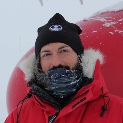
RT @esa_cryosat
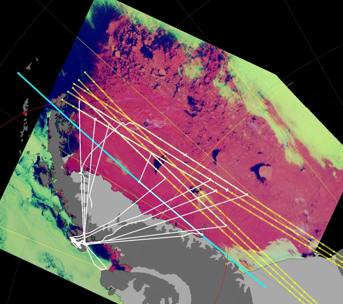
The weather has finally closed in, but what a campaign in Antarctica! 4 CryoSat tracks, a #CRYO2ICE track and a bonus #ICESat2 track 🙌🛩️ Adelaide Island site surveyed 👌 Time for the return trip with a flight to Punta Arenas. Thanks to @BAS_News for having us at Rothera! 🤩
Alessandro Di Bella · @alexdibella
16 followers · 24 posts · Server fediscience.org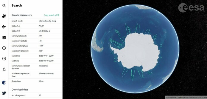
RT @esa_cryosat
🌍📊 Have you used http://cs2eo.org yet? 📊🌍 Whilst #CryoSat researchers are, right now, investigating Antarctic ice, you can browse coincident #CRYO2ICE tracks from wherever you are. Here's an image with data from #CryoSat & #ICESat2 within 2 hours of each other 👇👌
Tyler Sutterley · @tylersutterley
36 followers · 17 posts · Server mapstodon.spaceHi 👋 this is my #Introduction
Glaciologist and geodesist living in #Seattle. Scientist at the #UW Applied Physics Lab and affiliate at the #eScience Institute. Formerly a postdoc at #NASA Goddard Space Flight Center. Using #ICESat2 and #GRACEFO to look at our Earth's #polar regions. Squinter of #maps. Glorified #cat bed.
#Introduction #seattle #uw #escience #nasa #icesat2 #gracefo #polar #maps #cat
Alessandro Di Bella · @alexdibella
10 followers · 10 posts · Server fediscience.org
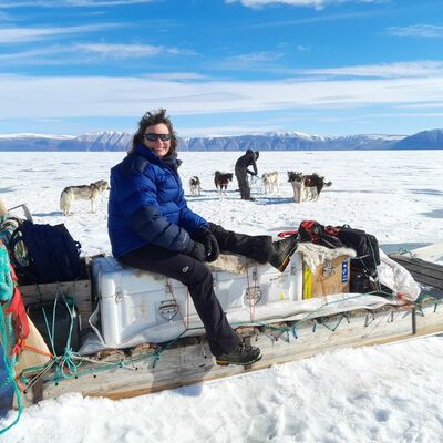
Best of luck!! 🤞🛰️❄️🛩️
---
RT @esa_cryosat
❄️ The Antarctic adventure begins 🛩️ Introducing the intrepid team of researchers descending on the south pole to improve satellite observations of Antarctic ice. In a week's time they'll be on the ice & in the air taking measurements to validate #CryoSat & #ICESat2 overhead /1
https://twitter.com/esa_cryosat/status/1597601429241630721
Alessandro Di Bella · @alexdibella
10 followers · 10 posts · Server fediscience.org

sebastian · @sebastian
36 followers · 982 posts · Server mastodon.uyTweet from NASA Earth (@NASAEarth), at May 6, 11:22 AM
318 gigatons.
That’s how much ice is lost every year from Antarctica and Greenland’s ice sheets, according to new science from @NASA_Ice's #ICESat2. https://t.co/PaydixOHRq
But… how much ice is that, really? 🤔 https://t.co/gotGPqw3yn