
Hub Mapeo Abierto LAC · @mapeoabierto_la
82 followers · 358 posts · Server mapstodon.space
Esto es en un par de horas! Inscríbanse YA a este taller de Edición Básica en OpenStreetMap que daremos en alianza con el Instituto Geográfico Agustín Codazzi @igaccolombia.
Se explicarán los elementos básicos de mapeo en la herramienta iD Editor, y se realizará un ejercicio de mapeo remoto coordinado.
.
Link de inscripción: https://events.teams.microsoft.com/event/3c1b1894-fe60-4601-b52a-26de9b6d9a29@ed49fe9a-6eea-47e6-bf52-ee9ecb5da807
.
#cartografia #geografia #mapeoabierto #mapas #datos #mapeadores #mapeo #datosabiertos #opensource #openstreetmap #ideditor #taller #workshop
#cartografia #Geografia #mapeoabierto #mapas #datos #mapeadores #mapeo #datosabiertos #opensource #OpenStreetMap #ideditor #taller #workshop

Nickname · @Nickname
-1 followers · 121 posts · Server mastodon.bayern@dubst3pp4
Gebäude und ganze Wege kannst du auch mit dem #iDeditor direkt auf der OpenStreetMap Webseite einzeichnen, je nach (Bundes-)Land gibt es auch Luftbilder mithilfe welcher du die Umrisse von Gebäuden oder Straßenzüge leicht eintragen kannst.
Beim nächsten mal wenn du wieder mit StreetComplete vorbeikommst tauchen dann auch neue Quests auf.
#StreetComplete hat außerdem noch verschiedene "Overlays" wenn du speziell auf Geschäfte, Radwege oder Parkplätze usw. achten willst.
Und wenn du auf der Karte gedrückt hältst kannst du Hinweise erstellen mit einer Notiz und Fotos, dann können andere Mapper diese Hinweise bearbeiten oder du selbst z.B. von Zuhause aus. Außerdem kannst du dort auch neue Wege erstellen mithilfe von GPS Erfassung während du also den weg abläufst.
@Strubbl

· @qeef
60 followers · 480 posts · Server en.osm.town
· @qeef
60 followers · 479 posts · Server en.osm.town@rapid Have you noticed, that RapiD v1 had big D at the end, referencing to the original iD editor, but Rapid v2 not? Interesting... #OpenStreetMap #iD #iDeditor

Irdi · @irdi
13 followers · 25 posts · Server defcon.social
Today members of the Open Street Map Albania user group came together @OpenLabsAlbania to map for #Malawi.
We contributed for two hours mapping buildings using #Ideditor and @openstreetmap .
#malawi #ideditor #disasterrecovery #openstreetmap #openlabsalbania

· @barefootstache
155 followers · 814 posts · Server en.osm.town#MappingChallenge (Day 173/200)
Two week progress at zoom level 14, whereas the north east section was done this past week.
The #idEditor is practical to fix simple misalignment of areas that are caught after doing detailed natural and landuse mapping as seen here.
Summary:
JOSM: 11
iD: 5
#MappingChallenge #ideditor #OpenStreetMap #beforeandafter

Alan McConchie · @alan
733 followers · 85 posts · Server subdued.social
Thanks to #OpenStreetMap user "archpdx", we will soon have "Taco Time Northwest" as a preset in the OSM iD editor. I love OpenStreetMap! https://github.com/osmlab/name-suggestion-index/commit/a5a9baf1069450944d92f7e8104f217d8ac2c56e #TacoTime #TacoTimeNorthwest #ideditor
#openstreetmap #tacotime #tacotimenorthwest #ideditor
· @barefootstache
123 followers · 600 posts · Server en.osm.town
#MappingChallenge (Day 40/50)
Finally brought the town Lazina (https://osm.org/go/0IpT2jLm) to an acceptable standard of map quality.
Finished mapping power line poles. One needs to be careful that they are not telephone line poles.
Summary:
#StreetComplete: 71
#osmand: 121
#iDeditor: 21
#MappingChallenge #streetcomplete #osmand #ideditor #OpenStreetMap #croatia
· @barefootstache
123 followers · 600 posts · Server en.osm.town#MappingChallenge (Day 39/50)
One of those days where I am just getting the absolute minimum in. Chose to update some building geometry.
Summary:
#iDeditor: 1
#MappingChallenge #ideditor #OpenStreetMap
· @barefootstache
123 followers · 600 posts · Server en.osm.town#MappingChallenge (Day 38/50)
Don't know what was up with my GPS today though still was able to map offline via Osmand.
Recently upgraded Osmand to 4.2.6 and love the improvements. It makes mapping so much more user friendly than before. Re-organising the quick actions, side menu, and drawer is golden.
Briefly used #OSMtracker because I had one of those rare situations where I actually needed it.
Summary:
#StreetComplete: 21
#osmand: 14
#iDeditor: 26
#MappingChallenge #osmtracker #streetcomplete #osmand #ideditor #OpenStreetMap
· @barefootstache
123 followers · 600 posts · Server en.osm.town#MappingChallenge (Day 35/50)
#JOSM seems like the only editor where one can pain-free import GPX files. Tried to do it with iDeditor with no success. Nonetheless I closed 40/100 notes.
Notes were made on days: 29, 32, 33, 34
Summary:
#iDeditor: 17
#MappingChallenge #josm #ideditor #OpenStreetMap
· @barefootstache
123 followers · 600 posts · Server en.osm.town#MappingChallenge (Day 26/50)
This is meant under
> Just some building geometry update.
Not really a big highlight. Though better than the default spammed version of buildings.
Summary:
#ideditor: 2
#MappingChallenge #ideditor #OpenStreetMap #beforeandafter
· @barefootstache
123 followers · 600 posts · Server en.osm.town#MappingChallenge (Day 14/50)
While walking to dinner was wondering what I can map and first thing that popped into my mind is `building:material=*` and `building:colour=*`.
On the way back, I realized that I can map the ditch/drain.
Do you know what is the difference between ditch and drain?
Summary:
#iDeditor: 3
#MappingChallenge #ideditor #OpenStreetMap
· @barefootstache
123 followers · 600 posts · Server en.osm.town#MappingChallenge (Day 13/50)
Did a round of quick mapping, about 4h worth. Added approximately 1k buildings within that time period.
The first two hours were painful, because my internet was acting up. Getting the satellite imagery to load was a task of patience. Luckily the internet sped up in the second half and then I could use the full power of quick mapping.
Quick mapping := quickly adding buildings without much care of details of the geometry
Summary:
#iDeditor: 35
#MappingChallenge #ideditor #OpenStreetMap

MapAm💜re · @MapAmore
523 followers · 1021 posts · Server en.osm.town@barefootstache @vespucci_editor
Are you qualifying that statement with better than #idEditor **on mobile**, for power users? 😁
I found that for many casual OSM users, with simple needs (editing attributes, adding POIs) they actually find #OSMapp more usable.
· @barefootstache
123 followers · 600 posts · Server en.osm.town#MappingChallenge (Day 08/50)
Tried out the @vespucci_editor for the first time. Only saw brief tutorials about it in the past. Took me a couple of minutes to get the hang of it.
For now I would rate it better than #iDeditor in power mapping, though not as good as #JOSM.
For my use-case it is perfect for mapping buildings and driveways. Adding new landuse will have to wait, though touching up existing ones is manageable.
Summary:
#vespucci: 13
#MappingChallenge #ideditor #josm #vespucci #OpenStreetMap
· @barefootstache
123 followers · 600 posts · Server en.osm.town#MappingChallenge (Day 07/50)
The rain today is forcing me to map from inside only. Though I got a bounty of fresh aerial images from the neighboring village, this will help a lot towards making it 3d complete.
Summary:
#MappingChallenge #drone #ideditor #OpenStreetMap
MapAm💜re · @MapAmore
523 followers · 1021 posts · Server en.osm.town
Is @vespucci_editor teasing us ? They just posted a photo #vespucci , the powerful mobile editor for #OpenStreetMap , on a desktop!
Can you imagine using #vespucci on the desktop?
It might be a viable, "simple" alternative to #JOSM, and could even compete against #iDeditor for user-friendliness .
#vespucci #OpenStreetMap #josm #ideditor
MapAm💜re · @MapAmore
523 followers · 1021 posts · Server en.osm.town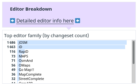
Interesting insights about the #Philippines' #OpenStreetMap activity using osm-monitor.com dashboard
#JOSM and #iDeditor are the top two editors, by changeset count, with #RapiD at a distant third. #GoMap leads in the number of objects changed for mobile editors.
A large number of people use the default #Bing imagery, even though #Maxar's is more recent. New editors aren't likely to know this when they're starting
#philippines #OpenStreetMap #josm #ideditor #rapid #gomap #bing #maxar
MapAm💜re · @MapAmore
523 followers · 1021 posts · Server en.osm.town
Somehow stumbled on #OsmApp , calling itself a "universal OpenStreetMap app" that looks very good for casual , everyday use of OSM on mobiles.
Pros - clean UI, vector tiles from #maptiler, search-as-you-type queries, PWA/multi-platform, custom layers
Cons - no routing, #idEditor
Users can leave OSM notes for issues or feedback, without a user account.
It uses #idEditor for editing but definitely isn't ideal on small screens, but usable in a pinch.