
ConstantOrbit · @constantorbit
939 followers · 2215 posts · Server hachyderm.ioAha. https://commutetimemap.com seems pretty good for what I need as a general idea.
(Although for transit looks like it only uses subway/trolley, no bus?)
#transit #BikeTooter #isochrone #publictransit

Rafael H M Pereira · @UrbanDemog
592 followers · 395 posts · Server datasci.social
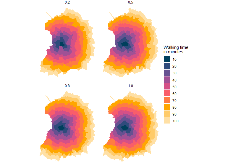
Playing around with the new isochrone() function from #r5rstats
https://github.com/ipeaGIT/r5r/issues/123#issuecomment-1636576356 #isochrone

Florin · @florin
291 followers · 778 posts · Server vis.social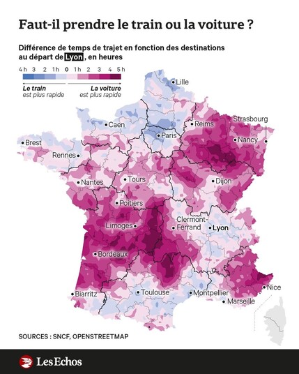
Now, what a nice isochrone map is this?
“Train or car? Difference in journey times by destination from Lyon, in hours”
Source: #LesEchos
I like the twist that the colors first mark whether it is faster to get there by train or by car.
#Mapping #mapstodon #isochrone #transport #trains #lyon #cartography #railway
#railway #cartography #lyon #trains #transport #isochrone #mapstodon #mapping #lesechos

Jake Coppinger · @jakecoppinger
331 followers · 265 posts · Server aus.socialHere's a demo of generating a isochrone chart for cycling from the cursor location in real time! The shape represents where cycling is easier/faster to go.
I spun up a server and downloaded the Valhalla source and OSM data for NSW. I made some edits to the Valhalla codebase to avoid roads with higher speed limits, and modified the frontend demo slightly. Only took two afternoons!
Looking forward to making further tweaks for Valhalla and seeing what interesting things I can make. I definitely think there's some bugs in my speed limit weightings.
#valhalla #openstreetmap #routing #isochrone #cycling #maps #osm #sydney #cpp #c++ #isochrone #nsw
#valhalla #openstreetmap #routing #isochrone #cycling #maps #osm #sydney #cpp #c #nsw

Gruff Owen · @gruffowen
53 followers · 20 posts · Server toot.wales
@gethin76 A few services use #openstreetmap data to do this.
Couple of examples:
Depending how serious you are, you could look into producing an #isochrone map yourself in #gis
#gis #isochrone #openstreetmap