Philipp · @philipp
204 followers · 1691 posts · Server social.anoxinon.deHabe mich weiter in CUSTOM ROMs eingelesen, weil ich über ein entgoogletes Smartphone nachdenke:
- Es gibt Smartphones wie das Samsung Knox, bei denen sich der Chip selbst unbrauchbar macht, wenn man einen Custom #ROM aufspielt 😮
- LineageOS aufspielen, ist mit mehr Arbeit verbunden, als ich dachte
- Fairphone 5 mit /e/OS klingt nach einer ziemlichen komfortable Alternative
https://www.kuketz-blog.de/lineageos-take-back-control-teil2/
#lineageos #samsung #knox #customROM #ROM #Google #Android #Fairphone5 #eos #murena
#rom #lineageos #samsung #knox #customrom #google #android #fairphone5 #eos #Murena
Evie (SleepyCatten) · @SleepyCatten
2421 followers · 11226 posts · Server cultofshiv.wtfI'm very sneaky.
I make posts, then see which folks reply to them nicely.
I then eventually remember to check the profiles of those folks & follow back the ones who pass a vibe check.
Gotta be sneaky; gotta be quick 😌
#knox #robertbenfer #klayworld #gif #animatedgif
EAS Watcher · @easwatch
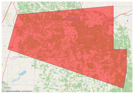
327 followers · 9414 posts · Server m.ai6yr.org#EAS for Ashland, #OH; #Knox, #OH; #Richland, #OH: National Weather Service: #TORNADO WARNING in this area until 3:15 PM EDT. Take shelter now in a basement or an interior room on the lowest floor of a sturdy building. If you are outdoors, in a mobile home, or in a vehicle, move to the closest substantial shelter and protect yourself from flying debris. Check media. Source: NWS Cleveland OH** DO NOT RELY ON THIS FEED FOR LIFE SAFETY, SEEK OUT OFFICIAL SOURCES ***
#EAS #oh #knox #richland #tornado
EAS Watcher · @easwatch
327 followers · 9413 posts · Server m.ai6yr.org#EAS for Ashland, ###OH; ###Knox, ###OH; ###Richland, ###OH: National Weather Service: #TORNADO WARNING in this area until 3:15 PM EDT. Take shelter now in a basement or an interior room on the lowest floor of a sturdy building. If you are outdoors, in a mobile home, or in a vehicle, move to the closest substantial shelter and protect yourself from flying debris. Check media. Source: NWS Cleveland OH** DO NOT RELY ON THIS FEED FOR LIFE SAFETY, SEEK OUT OFFICIAL SOURCES ***
#EAS #oh #knox #richland #tornado
EAS Watcher · @easwatch
327 followers · 9413 posts · Server m.ai6yr.org#EAS for Ashland, ##OH; ##Knox, ##OH; ##Richland, ##OH: #Tornado Warning issued August 12 at 2:40PM EDT until August 12 at 3:15PM EDT by NWS Cleveland OH Source: NWS Cleveland OH** DO NOT RELY ON THIS FEED FOR LIFE SAFETY, SEEK OUT OFFICIAL SOURCES ***
#EAS #oh #knox #richland #tornado
EAS Watcher · @easwatch
327 followers · 9413 posts · Server m.ai6yr.org#EAS for Ashland, #OH; #Knox, #OH; #Richland, #OH: #Tornado Warning issued August 12 at 2:40PM EDT until August 12 at 3:15PM EDT by NWS Cleveland OH Source: NWS Cleveland OH** DO NOT RELY ON THIS FEED FOR LIFE SAFETY, SEEK OUT OFFICIAL SOURCES ***
#EAS #oh #knox #richland #tornado
BakersRelay · @BakerRL75
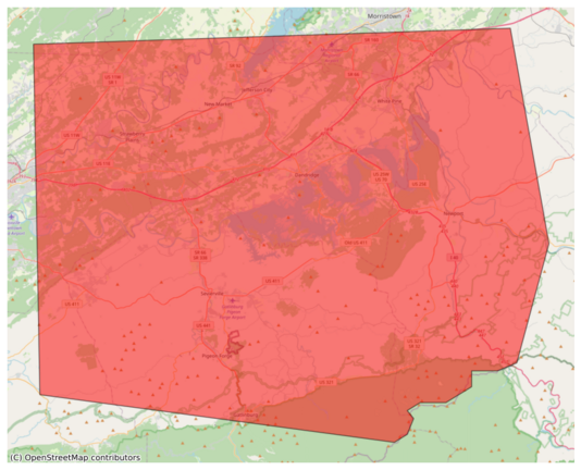
795 followers · 33171 posts · Server m.ai6yr.org#EAS for Blount, ##TN; ##Cocke, ##TN; ##Grainger, ##TN; ##Greene, ##TN; ##Hamblen, ##TN; ##Jefferson, ##TN; ##Knox, ##TN; ##Sevier, ##TN; ##Union, ##TN: National Weather Service: SEVERE THUNDERSTORM WARNING in effect for this area until 3:45 PM EDT for DESTRUCTIVE 80 mph winds. Take shelter in a sturdy building, away from windows. Flying debris may be deadly to those caught without shelter. Source: NWS Morristown TN** DO NOT RELY ON THIS FEED FOR LIFE SAFETY,
#tnwx #EAS #tn #cocke #grainger #greene #hamblen #jefferson #knox #sevier #union
EAS Watcher · @easwatch
316 followers · 8843 posts · Server m.ai6yr.org#EAS for Blount, #TN; #Cocke, #TN; #Grainger, #TN; #Greene, #TN; #Hamblen, #TN; #Jefferson, #TN; #Knox, #TN; #Sevier, #TN; #Union, #TN: National Weather Service: SEVERE THUNDERSTORM WARNING in effect for this area until 3:45 PM EDT for DESTRUCTIVE 80 mph winds. Take shelter in a sturdy building, away from windows. Flying debris may be deadly to those caught without shelter. Source: NWS Morristown TN** DO NOT RELY ON THIS FEED FOR LIFE SAFETY, SEEK OUT OFFICIAL SOURCES ***
#EAS #tn #cocke #grainger #greene #hamblen #jefferson #knox #sevier #union
EAS Watcher · @easwatch
316 followers · 8843 posts · Server m.ai6yr.org#EAS for Blount, ##TN; ##Cocke, ##TN; ##Grainger, ##TN; ##Greene, ##TN; ##Hamblen, ##TN; ##Jefferson, ##TN; ##Knox, ##TN; ##Sevier, ##TN; ##Union, ##TN: National Weather Service: SEVERE THUNDERSTORM WARNING in effect for this area until 3:45 PM EDT for DESTRUCTIVE 80 mph winds. Take shelter in a sturdy building, away from windows. Flying debris may be deadly to those caught without shelter. Source: NWS Morristown TN** DO NOT RELY ON THIS FEED FOR LIFE SAFETY, SEEK OUT OFFICIAL SOURCES ***
#EAS #tn #cocke #grainger #greene #hamblen #jefferson #knox #sevier #union
EAS Watcher · @easwatch
316 followers · 8843 posts · Server m.ai6yr.org#EAS for Blount, #TN; #Cocke, #TN; #Grainger, #TN; #Greene, #TN; #Hamblen, #TN; #Jefferson, #TN; #Knox, #TN; #Sevier, #TN; #Union, #TN: Severe Thunderstorm Warning issued August 7 at 2:39PM EDT until August 7 at 3:45PM EDT by NWS Morristown TN Source: NWS Morristown TN** DO NOT RELY ON THIS FEED FOR LIFE SAFETY, SEEK OUT OFFICIAL SOURCES ***
#EAS #tn #cocke #grainger #greene #hamblen #jefferson #knox #sevier #union
EAS Watcher · @easwatch
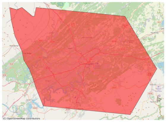
316 followers · 8840 posts · Server m.ai6yr.org#EAS for Anderson, #TN; #Blount, #TN; #Grainger, #TN; #Jefferson, #TN; #Knox, #TN; #Loudon, #TN; #Sevier, #TN; #Union, #TN: National Weather Service: SEVERE THUNDERSTORM WARNING in effect for this area until 3:00 PM EDT for DESTRUCTIVE 80 mph winds. Take shelter in a sturdy building, away from windows. Flying debris may be deadly to those caught without shelter. Source: NWS Morristown TN** DO NOT RELY ON THIS FEED FOR LIFE SAFETY, SEEK OUT OFFICIAL SOURCES ***
#EAS #tn #blount #grainger #jefferson #knox #loudon #sevier #union
BakersRelay · @BakerRL75
795 followers · 33171 posts · Server m.ai6yr.org#EAS for Anderson, ##TN; ##Blount, ##TN; ##Grainger, ##TN; ##Jefferson, ##TN; ##Knox, ##TN; ##Loudon, ##TN; ##Sevier, ##TN; ##Union, ##TN: National Weather Service: SEVERE THUNDERSTORM WARNING in effect for this area until 3:00 PM EDT for DESTRUCTIVE 80 mph winds. Take shelter in a sturdy building, away from windows. Flying debris may be deadly to those caught without shelter. Source: NWS Morristown TN** DO NOT RELY ON THIS FEED FOR LIFE SAFETY, SEEK OUT OFFICIAL SOURCES ***
#tnwx #EAS #tn #blount #grainger #jefferson #knox #loudon #sevier #union
EAS Watcher · @easwatch
316 followers · 8839 posts · Server m.ai6yr.org#EAS for Anderson, ##TN; ##Blount, ##TN; ##Grainger, ##TN; ##Jefferson, ##TN; ##Knox, ##TN; ##Loudon, ##TN; ##Sevier, ##TN; ##Union, ##TN: National Weather Service: SEVERE THUNDERSTORM WARNING in effect for this area until 3:00 PM EDT for DESTRUCTIVE 80 mph winds. Take shelter in a sturdy building, away from windows. Flying debris may be deadly to those caught without shelter. Source: NWS Morristown TN** DO NOT RELY ON THIS FEED FOR LIFE SAFETY, SEEK OUT OFFICIAL SOURCES ***
#EAS #tn #blount #grainger #jefferson #knox #loudon #sevier #union
EAS Watcher · @easwatch
316 followers · 8839 posts · Server m.ai6yr.org#EAS for Anderson, #TN; #Blount, #TN; #Grainger, #TN; #Jefferson, #TN; #Knox, #TN; #Loudon, #TN; #Sevier, #TN; #Union, #TN: Severe Thunderstorm Warning issued August 7 at 2:24PM EDT until August 7 at 3:00PM EDT by NWS Morristown TN Source: NWS Morristown TN** DO NOT RELY ON THIS FEED FOR LIFE SAFETY, SEEK OUT OFFICIAL SOURCES ***
#EAS #tn #blount #grainger #jefferson #knox #loudon #sevier #union
EAS Watcher · @easwatch
316 followers · 8810 posts · Server m.ai6yr.org#EAS for Bell, #KY; #Clay, #KY; #Harlan, #KY; #Knox, #KY; #Leslie, #KY: National Weather Service: #TORNADO WARNING in this area until 1:15 PM EDT. Take shelter now in a basement or an interior room on the lowest floor of a sturdy building. If you are outdoors, in a mobile home, or in a vehicle, move to the closest substantial shelter and protect yourself from flying debris. Check media. Source: NWS Jackson KY** DO NOT RELY ON THIS FEED FOR LIFE SAFETY, SEEK OUT OFFICIAL SOURCES ***
#EAS #ky #clay #harlan #knox #leslie #tornado
EAS Watcher · @easwatch
316 followers · 8807 posts · Server m.ai6yr.org#EAS for Bell, ##KY; ##Clay, ##KY; ##Harlan, ##KY; ##Knox, ##KY; ##Leslie, ##KY: National Weather Service: #TORNADO WARNING in this area until 1:15 PM EDT. Take shelter now in a basement or an interior room on the lowest floor of a sturdy building. If you are outdoors, in a mobile home, or in a vehicle, move to the closest substantial shelter and protect yourself from flying debris. Check media. Source: NWS Jackson KY** DO NOT RELY ON THIS FEED FOR LIFE SAFETY, SEEK OUT OFFICIAL SOURCES ***
#EAS #ky #clay #harlan #knox #leslie #tornado
EAS Watcher · @easwatch
316 followers · 8806 posts · Server m.ai6yr.org#EAS for Bell, #KY; #Clay, #KY; #Harlan, #KY; #Knox, #KY; #Leslie, #KY: #Tornado Warning issued August 7 at 12:38PM EDT until August 7 at 1:15PM EDT by NWS Jackson KY Source: NWS Jackson KY** DO NOT RELY ON THIS FEED FOR LIFE SAFETY, SEEK OUT OFFICIAL SOURCES ***
#EAS #ky #clay #harlan #knox #leslie #tornado
BakersRelay · @BakerRL75
710 followers · 26089 posts · Server m.ai6yr.org#EAS for Fulton, #IL; #Knox, #IL: National Weather Service: SEVERE THUNDERSTORM WARNING in effect for this area until 12:00 PM CDT for DESTRUCTIVE 80 mph winds. Take shelter in a sturdy building, away from windows. Flying debris may be deadly to those caught without shelter. Source: NWS Lincoln IL** DO NOT RELY ON THIS FEED FOR LIFE SAFETY, SEEK OUT OFFICIAL SOURCES ***
EAS Watcher · @easwatch
246 followers · 7100 posts · Server m.ai6yr.org#EAS for Fulton, #IL; #Knox, #IL: National Weather Service: SEVERE THUNDERSTORM WARNING in effect for this area until 12:00 PM CDT for DESTRUCTIVE 80 mph winds. Take shelter in a sturdy building, away from windows. Flying debris may be deadly to those caught without shelter. Source: NWS Lincoln IL** DO NOT RELY ON THIS FEED FOR LIFE SAFETY, SEEK OUT OFFICIAL SOURCES ***


