
Service IST de l'IRD · @IST_IRD
3 followers · 4 posts · Server earthstream.social#Dataset #DataSuds : Labiadh et al. 2023, "#Wind #erosion flux measured over various #landcover types in the arid region of southern #Tunisia during 2012-2016", https://doi.org/10.23708/AO2YFT #researchdata #africa #northAfrica
#dataset #datasuds #wind #erosion #landcover #tunisia #researchdata #africa #northafrica

OpenGeoHub Foundation · @opengeohub
208 followers · 34 posts · Server fosstodon.org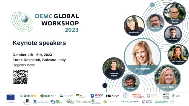
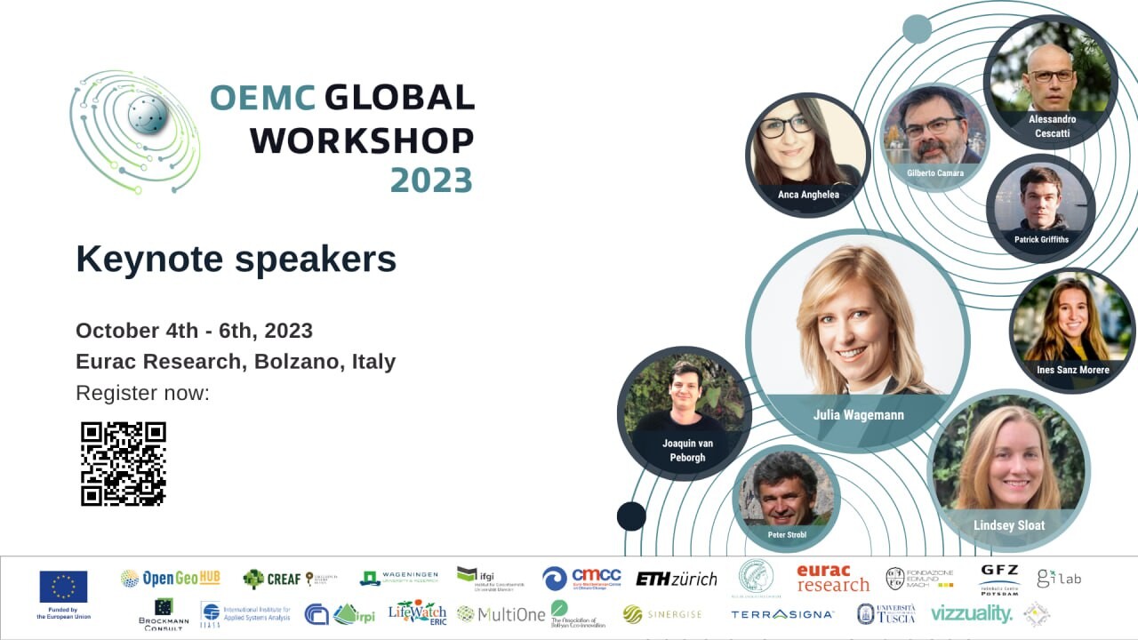
📆 This year, the 2023 #OpenEarthMonitor (OEMC) Global Workshop will host a variety of formats, from keynote lectures to oral talks, workshops and poster presentations!
9 experts will host keynote lectures on #open #EO #greentransition #OpenClimate #DestinE #landuse #landcover #modeling #Openscience #environmentalcrises . In addition, 18 workshops will be hosted where you can get training in using open EO tools and data.
To know more about the program visit: https://earthmonitor.org/gw2023/
#openearthmonitor #open #eo #greentransition #openclimate #DestinE #landuse #landcover #modeling #openscience #environmentalcrises

Jakub Nowosad · @nowosad
856 followers · 168 posts · Server fosstodon.orgNew NLCD products for the year 2021 are now available, and starting from 2024, there will be a new land cover product for the conterminous United States at 30-meter spatial resolution and on an annual time step for the years 1985-2023.
Read more at https://www.usgs.gov/centers/eros/news/nlcd-2021-now-available

Frédéric Cantat 🌍 · @CanFre
297 followers · 612 posts · Server mamot.fr
RT @IGNFrance@twitter.com
[#AIChallenge]📢 Already 100 registrations for the #FLAIR-2 scientific challenge!
FLAIR is a dataset for #AI model training in #landcover domain:
🛩️70,000 aerial imagery patches with pixel-based annotations
🛰️50,000 Sentinel-2 satellite
👨🏻💻 https://codalab.lisn.upsaclay.fr/competitions/13447
#aichallenge #flair #ai #landcover

GregCocks · @GregCocks
553 followers · 490 posts · Server techhub.social
Perspectives - A Bird’s-Eye View Of Landscapes [Sweden]
--
https://iexposure.ikfoundation.org/perspectives <-- shared technical article
--
#GIS #spatial #mapping #remotesensing #aerial #satellite #drone #imagery #history #archaeology #urban #industrial #agriculture #iBIRDSEYE #Sweden #records #landforms #geomorphology #examples #usecases #appliedscience #ancientmonuments #burial #burialmounds #overview #SouthernSweden #spatialanalysis #landcover #landuse
#IKFoundation #SwedishNationalArchives
#gis #spatial #mapping #remotesensing #aerial #satellite #drone #imagery #history #archaeology #urban #industrial #agriculture #ibirdseye #sweden #records #landforms #geomorphology #examples #usecases #appliedscience #ancientmonuments #burial #burialmounds #overview #southernsweden #spatialanalysis #landcover #landuse #ikfoundation #swedishnationalarchives

BNHR.XYZ :tux: :qgis: · @bnhrdotxyz
55 followers · 46 posts · Server fosstodon.org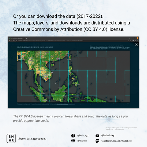
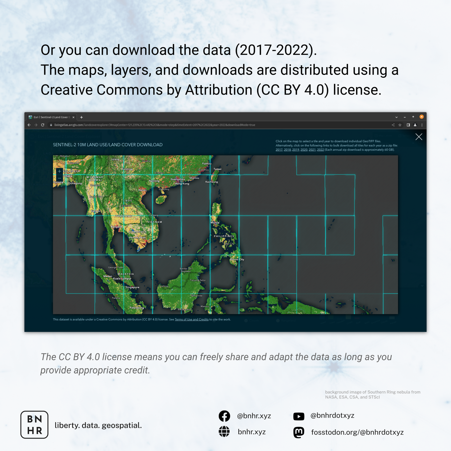
The maps, layers, and downloads are distributed using a Creative Commons by Attribution (CC BY 4.0) license which means you can freely share and adapt the data as long as you provide appropriate credit.
#GIS #GISChat #QGIS #Geospatial #LandCover #RemoteSensing #Sentinel2 #Data #OpenData
#gis #gischat #qgis #geospatial #landcover #remotesensing #sentinel2 #data #opendata
BNHR.XYZ :tux: :qgis: · @bnhrdotxyz
55 followers · 46 posts · Server fosstodon.org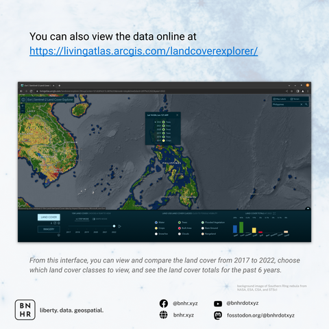
You can also view the data online or download it at https://livingatlas.arcgis.com/landcoverexplorer/ or learn more about the data at https://livingatlas.arcgis.com/landcover/
🧵4/
#GIS #GISChat #QGIS #Geospatial #LandCover #RemoteSensing #Sentinel2
#gis #gischat #qgis #geospatial #landcover #remotesensing #sentinel2
BNHR.XYZ :tux: :qgis: · @bnhrdotxyz
55 followers · 42 posts · Server fosstodon.org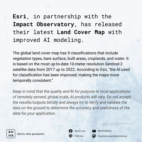
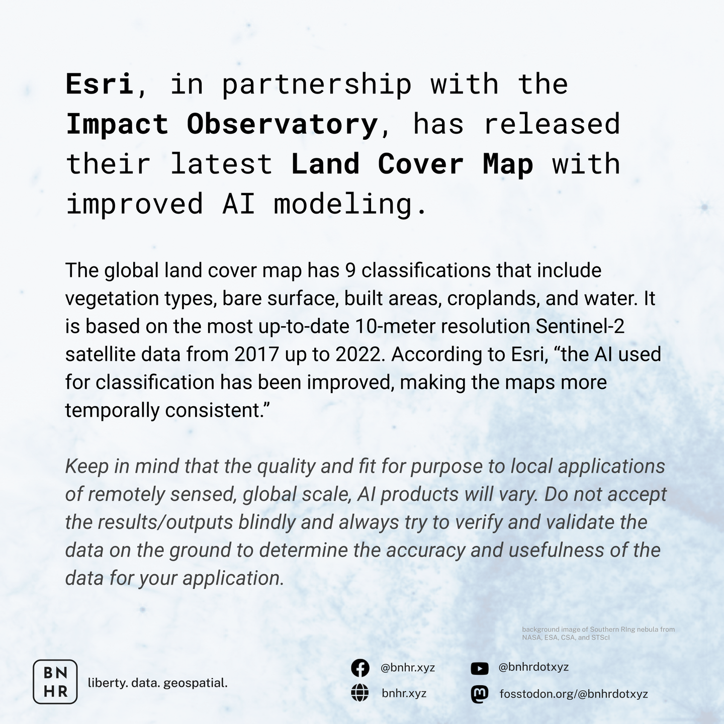
LOOKING FOR UPDATED LAND COVER MAPS?
Esri, in partnership with the Impact Observatory, released their latest Land Cover Map with improved AI modeling.
IMPORTANT: The quality and fit for purpose to local applications of remotely sensed, global scale, AI products will vary. Do not accept the results/outputs blindly and always try to verify/validate to determine the accuracy/usefulness of the data for your application.
🧵 1/
#GIS #GISChat #QGIS #Geospatial #LandCover #RemoteSensing #Sentinel2
#gis #gischat #qgis #geospatial #landcover #remotesensing #sentinel2
GregCocks · @GregCocks
398 followers · 433 posts · Server techhub.social
Geomorphometry - A Brief Guide
--
https://doi.org/10.1016/S0166-2481(08)00001-9 <-- shared paper
--
https://geomorphometry.org/ <-- International Society for Geomorphometry home page
--
#GIS #spatial #mapping #elevation #remotesensing #data #digital #civilengineering #science #visualization #geometry #military #algorithms #society #visualisation #model #modeling #geomorphology #landcover #geomorphometry #quantitative #landsurface #analysis #spatialanalysis #spatiotemporal #terrainanalysis #physicalgeography #geography #geology #topography #landforms #watersheds #surfacemodel #algorithms #interpretation #gischat
#gis #spatial #mapping #elevation #remotesensing #data #digital #civilengineering #science #visualization #geometry #military #algorithms #society #visualisation #model #modeling #geomorphology #landcover #geomorphometry #quantitative #landsurface #analysis #spatialanalysis #spatiotemporal #terrainanalysis #PhysicalGeography #geography #geology #topography #landforms #watersheds #surfacemodel #interpretation #gischat
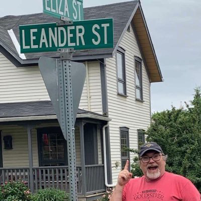
Leander · @LeanderCampbell
21 followers · 36 posts · Server mas.to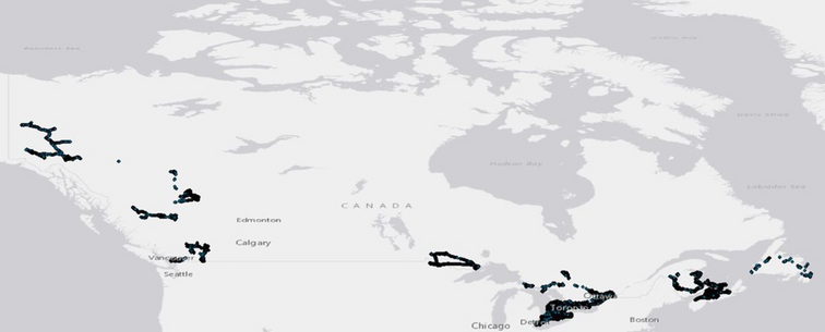
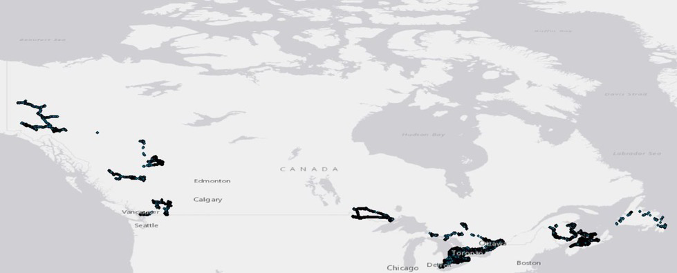
6 Provinces & 1 Territory
Now available to download all our #cropmap22 #landcover observation points that were gathered by us, our colleagues from AAFC Research Centres across Canada, and our provincial supporters.
That's over 71,000 points...for free.
https://open.canada.ca/data/en/dataset/503a3113-e435-49f4-850c-d70056788632
#earthobservation #remotesensing #gis #gischat #agriculture #Canada #CdnAg #ontario #novascotia #pei #newfoundland #britishcolumbia #yukon
#yukon #britishcolumbia #newfoundland #pei #novascotia #ontario #CdnAg #Canada #agriculture #gischat #gis #remotesensing #earthobservation #landcover #cropmap22

data.europa.eu · @EU_opendata
261 followers · 1214 posts · Server respublicae.eu
How has #landcover and #landuse changed over the years in the EU? Check out our latest data story in our #HighValueDatasets series and discover Europe's landscapes through #EUOpenData 🌳
Read the story here 👉 https://europa.eu/!RMF7pW
🐦🔗: https://n.respublicae.eu/EU_opendata/status/1649035227623460866
#landcover #LandUse #HighValueDatasets #EUopendata
GregCocks · @GregCocks
203 followers · 261 posts · Server techhub.social
Dynamic World, Near Real-Time Global 10 Metre Land Use Land Cover Mapping
--
https://doi.org/10.1038/s41597-022-01307-4 <-- shared paper
--
#GIS #spatial #mapping #landcover #processeddata #deeplearning #AI #landuse #remotesensing #global #timelag #automation #NRT #LULC #NLCD #satellite #Sentinel #Sentinel2 #DynamicWorld #NDVI #machinelearning #artificialintelligence
#gis #spatial #mapping #landcover #processeddata #deeplearning #AI #landuse #remotesensing #global #timelag #automation #NRT #lulc #nlcd #satellite #sentinel #sentinel2 #dynamicworld #ndvi #machinelearning #artificialintelligence
GregCocks · @GregCocks
198 followers · 255 posts · Server techhub.social
U.S. Forest Service National Riparian Areas Base Map For The Conterminous United States In 2019
--
https://www.fs.usda.gov/rds/archive/catalog/RDS-2019-0030 <-- shared paper
--
https://storymaps.arcgis.com/stories/8cd69adaaaf541c78f8d867f0ec6b6ef <-- shared story map
--
#GIS #spatial #mapping #opendata #riparian #areas #CONUS #USA #basemaps #ecosystems #vegetation #soil #characteristics #environment #survey #spatialanalysis #monitoring #planning #management #policy #framework #geospatialdatasets #national #raster #floodheight #hydrology #water #NHD #WBD #NHDPlus #hydrologic #wetlands #3DEP #elevation #remotesensing #MRLC #landcover #NLCD #interagency #cooperation
#USFS #USDA #USGS #USFWS
#gis #spatial #mapping #opendata #riparian #areas #conus #USA #basemaps #ecosystems #vegetation #soil #characteristics #Environment #survey #spatialanalysis #monitoring #planning #management #policy #framework #geospatialdatasets #national #raster #floodheight #hydrology #water #nhd #wbd #nhdplus #hydrologic #wetlands #3dep #elevation #remotesensing #mrlc #landcover #nlcd #interagency #cooperation #usfs #usda #usgs #usfws
GregCocks · @GregCocks
198 followers · 251 posts · Server techhub.social
Hidden Vulnerability Of US Atlantic Coast To Sea-Level Rise Due To Vertical Land Motion
--
https://doi.org/10.1038/s41467-023-37853-7 <-- shared paper
--
#GIS #spatial #mapping #climatechange #sealevelrise #SLR #data #AtlanticCoast #risk #hazard #elevation #subsidence #rates #land #remotesensing #geodesy #geodetic #satellite #coast #coastal #landcover #vulnerability #marshes #coastalmarshes #wetlands #environmental #risk #hazard #vulnerability #vulnerabilitymanagement #mitigation #spatialanalysis #spatiotemporal #model #modeling #vertical #land #motion
#gis #spatial #mapping #climatechange #sealevelrise #slr #data #atlanticcoast #risk #hazard #elevation #subsidence #rates #land #remotesensing #Geodesy #geodetic #satellite #coast #coastal #landcover #vulnerability #marshes #coastalmarshes #wetlands #environmental #vulnerabilitymanagement #mitigation #spatialanalysis #spatiotemporal #model #modeling #vertical #motion
Leander · @LeanderCampbell
19 followers · 34 posts · Server mas.to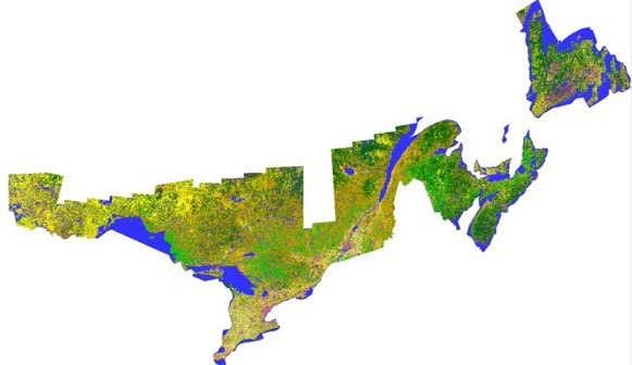
This completes the eastern half of Canadian agriculture for #cropmap22.
The team has had numerous issues outside of our control slow us down this winter. We're definitely running behind where we typically would be. But we're continuing to push through as best as we can. #RemoteSensing #CdnAg #LandCover #gischat
#gischat #landcover #CdnAg #remotesensing #cropmap22
Leander · @LeanderCampbell
19 followers · 31 posts · Server mas.to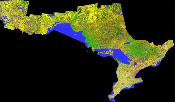
Now available for download, our 2022 crop inventory map of Ontario. #ontag #cdnag #cropmap22 #RemoteSensing #LandCover #gischat
https://open.canada.ca/data/en/dataset/ba2645d5-4458-414d-b196-6303ac06c1c9
#gischat #landcover #remotesensing #cropmap22 #CdnAg #ontag
GregCocks · @GregCocks
182 followers · 226 posts · Server techhub.social
Elevation-Based Probabilistic Mapping Of Irregularly Flooded Wetlands Along The Northern Gulf Of Mexico Coast
--
https://www.sciencedirect.com/science/article/pii/S0034425723000020 <-- shared paper
--
https://doi.org/10.5066/P9MLO26U <-- open access to study’s data
--
#GIS #spatial #probablistic #mapping #coastal #wetlands #elevation #uncertainty #LiDAR #MonteCarloSimulation #spatialautocorrelation #gischat #flooded #flooding #GulfOfMexico #MHW #datum #tidal #ecosystem #wildlife #fish #habitat #erosion #protection #SLR #sealevelrise #climatechange #hydrospatial #extremestorms #stormsurge #management #mitigation #spatialanalysis #spatiotemporal #changecontrol #extremeweather #landuse #landcover #remotesensing #model #modeling #numericalmodeling #probabilisticmap #accuracy #precision #corrleation #errormetrics #statistics #geostatistics #opendata #water #hydrology #data #food #digital
#gis #spatial #probablistic #mapping #coastal #wetlands #elevation #uncertainty #lidar #montecarlosimulation #spatialautocorrelation #gischat #flooded #flooding #gulfofmexico #mhw #datum #tidal #ecosystem #wildlife #fish #habitat #erosion #protection #slr #sealevelrise #climatechange #hydrospatial #extremestorms #stormsurge #management #mitigation #spatialanalysis #spatiotemporal #changecontrol #extremeweather #landuse #landcover #remotesensing #model #modeling #numericalmodeling #probabilisticmap #accuracy #precision #corrleation #errormetrics #statistics #geostatistics #opendata #water #hydrology #data #Food #digital

Fiona Gregory · @fionag11
37 followers · 101 posts · Server mapstodon.space
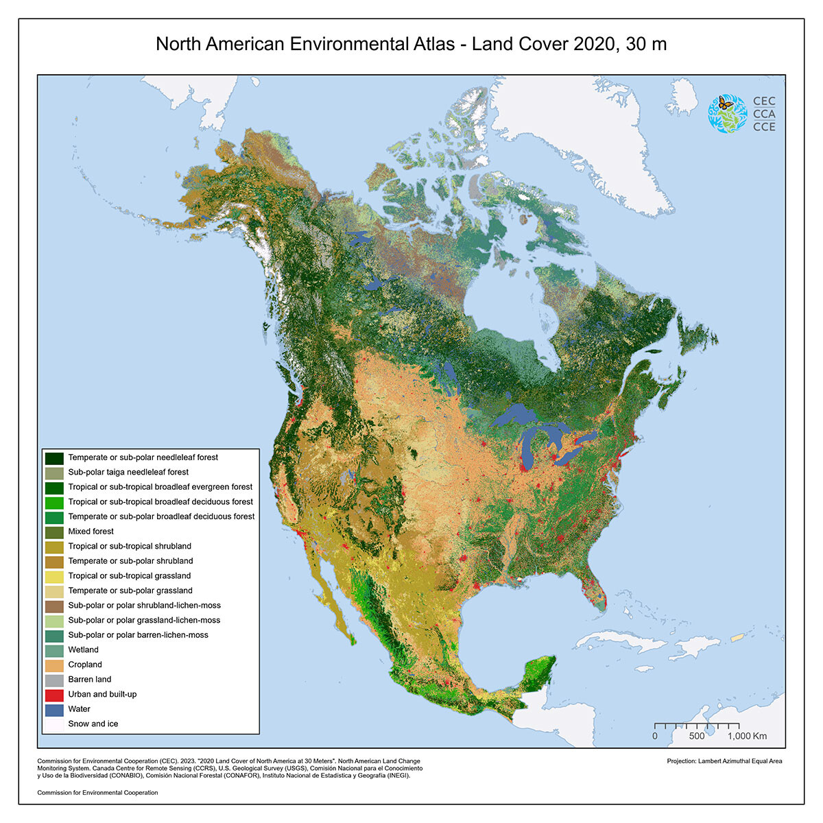
The Commission for Environmental Cooperation has just published an integrated North American landcover layer http://www.cec.org/north-american-environmental-atlas/land-cover-30m-2020/ #landcover
GregCocks · @GregCocks
149 followers · 167 posts · Server techhub.social
New LiDAR-Based Elevation Model Shows Greatest Increase In Global Coastal Exposure To Flooding To Be Caused By Early-Stage Sea-Level Rise
--
https://doi.org/10.1029/2022EF002880 <-- shared paper
--
#GIS #spatial #mapping #remotesensing #satellite #LiDAR #icesat #icesat2 #global #SLR #sealevelrise #elevation #model #modeling #data #future #spatialanalysis #spatiotemporal #marine #hydrology #climatechange #lowland #landcover #NLCD #coastal #flooding #innundation #land #prediction #monitoring #emergencypreparedness #opendata
#gis #spatial #mapping #remotesensing #satellite #lidar #icesat #icesat2 #global #slr #sealevelrise #elevation #model #modeling #data #future #spatialanalysis #spatiotemporal #marine #hydrology #climatechange #lowland #landcover #nlcd #coastal #flooding #innundation #land #prediction #monitoring #emergencypreparedness #opendata

Copernicus EU · @CopernicusEU
1718 followers · 7480 posts · Server respublicae.eu
RT @CopernicusLand: New #CLMS #landcover product! 📢
Introducing CLC+ BB raster, part of the next generation CORINE:
➡️1 map, 11 land cover classes
➡️gap-free coverage over Europe at 10m resolution
➡️free and open access
Read more on: https://land.copernicus.eu/news/new-copernicus-product-launch-clc-bb-backbone-raster
🐦🔗: https://n.respublicae.eu/CopernicusEU/status/1625391229537079298