GregCocks · @GregCocks
612 followers · 555 posts · Server techhub.socialUSGS Study Estimating A Monetary Value For Floodplain Ecosystem Services In The Chesapeake Bay And Delaware River Watersheds
--
https://www.usgs.gov/centers/chesapeake-bay-activities/science/floodplains-provide-millions-dollars-benefits-every-year <-- shared technical article
--
https://doi.org/10.1016/j.jenvman.2023.118747 <-- shared paper
--
#GIS #spatial #mapping #model #modeling #spatialanalysis #spatiotemporal #flood #flooding #floodinnundation #innundation #extremeweather #climatechange #watersheds #floodengineering #floodplains #nutrients #sediments #sedimentation #fluvial #soils #erosion #floodwaters #agriculture #farming #economics #accounting #mitigation #tradeoffs #management #landforms #geomorphology #ecosystems #publicsafety #communityhealth #appliedscience #water #hydrology #benefits #benefitstransfer #regulation #quantification #value #loss #lossanddamage #lossadjusting #Hazus #ChesapeakeBay #DelawareRiver
@usgs
#gis #spatial #mapping #model #modeling #spatialanalysis #spatiotemporal #flood #flooding #floodinnundation #innundation #extremeweather #climatechange #watersheds #floodengineering #floodplains #nutrients #sediments #sedimentation #fluvial #soils #erosion #floodwaters #agriculture #farming #economics #accounting #mitigation #tradeoffs #management #landforms #geomorphology #ecosystems #publicsafety #communityhealth #appliedscience #water #hydrology #benefits #benefitstransfer #regulation #quantification #value #loss #LossAndDamage #lossadjusting #hazus #ChesapeakeBay #delawareriver
GregCocks · @GregCocks
604 followers · 545 posts · Server techhub.socialWorld's Beaches Are Changing Because Of Climate Change
--
https://theconversation.com/worlds-beaches-are-changing-because-of-climate-change-green-thinking-is-needed-to-save-them-211953 <-- shared article
--
https://doi.org/10.1080/03736245.2023.2193565 <-- shared paper
--
#GIS #spatial #mapping #anthropogenic #climatechange #coast #coastline #coastalprocesses #greeninfrastructure #sandybeaches #beaches #mitigation #coastalengineering #coastalcommunities #mangroves #rockyshorelines #rivers #estuaries #hydro #water #hydrospatial #sanddunes #landforms #geomorphology #sealevel #SLR #sealevelrise #Anthropocene #sediment #sedimentation #innundation #erosion #protection #urbanisation #landusechange #landuseplanning #planning #resilience #ecosystems #environmental #solutions #ecology #southafrica
#gis #spatial #mapping #anthropogenic #climatechange #coast #coastline #coastalprocesses #greeninfrastructure #sandybeaches #beaches #mitigation #coastalengineering #coastalcommunities #mangroves #rockyshorelines #rivers #estuaries #Hydro #water #hydrospatial #sanddunes #landforms #geomorphology #sealevel #slr #sealevelrise #anthropocene #sediment #sedimentation #innundation #erosion #protection #urbanisation #landusechange #landuseplanning #planning #resilience #ecosystems #environmental #solutions #ecology #southafrica
GregCocks · @GregCocks
583 followers · 522 posts · Server techhub.socialMountains Are Collapsing - A Swiss Mountain Peak Fell Apart, Sending 3.5 Million Cubic Feet Of Rock Into The Valley Below - Scientists Warn Climate Change Could Make More Mountains Crumble.
--
https://www.businessinsider.com/mountains-switzerland-collapsing-from-permafrost-melt-2023-8 <-- shared media article
--
#GIS #spatial #mapping #model #modeling #prediction #geology #engineeringgeology #massmovement #global #landslide #debrisflow #mudslide #mountain #cryosphere #glacier #snow #ice #permafrost #water #hydrology #rockfall #EuropeanAlps #europe #SouthernAlps #newzealand #andes #peru #indigeneous #firstnation #risk #hazard #publicsafety #climate #melting #snowandicemanagement #climatechange #landforms #change #geomorphology #globalwarming #IPCC #naturalhazard #geologichazards
#gis #spatial #mapping #model #modeling #prediction #geology #engineeringgeology #massmovement #global #landslide #debrisflow #mudslide #mountain #cryosphere #glacier #snow #ice #permafrost #water #hydrology #rockfall #europeanalps #Europe #southernalps #newzealand #Peru #indigeneous #firstnation #risk #hazard #publicsafety #climate #melting #snowandicemanagement #climatechange #landforms #change #geomorphology #globalwarming #ipcc #naturalhazard #geologichazards #andes
GregCocks · @GregCocks
553 followers · 490 posts · Server techhub.socialPerspectives - A Bird’s-Eye View Of Landscapes [Sweden]
--
https://iexposure.ikfoundation.org/perspectives <-- shared technical article
--
#GIS #spatial #mapping #remotesensing #aerial #satellite #drone #imagery #history #archaeology #urban #industrial #agriculture #iBIRDSEYE #Sweden #records #landforms #geomorphology #examples #usecases #appliedscience #ancientmonuments #burial #burialmounds #overview #SouthernSweden #spatialanalysis #landcover #landuse
#IKFoundation #SwedishNationalArchives
#gis #spatial #mapping #remotesensing #aerial #satellite #drone #imagery #history #archaeology #urban #industrial #agriculture #ibirdseye #sweden #records #landforms #geomorphology #examples #usecases #appliedscience #ancientmonuments #burial #burialmounds #overview #southernsweden #spatialanalysis #landcover #landuse #ikfoundation #swedishnationalarchives
GregCocks · @GregCocks
398 followers · 433 posts · Server techhub.socialGeomorphometry - A Brief Guide
--
https://doi.org/10.1016/S0166-2481(08)00001-9 <-- shared paper
--
https://geomorphometry.org/ <-- International Society for Geomorphometry home page
--
#GIS #spatial #mapping #elevation #remotesensing #data #digital #civilengineering #science #visualization #geometry #military #algorithms #society #visualisation #model #modeling #geomorphology #landcover #geomorphometry #quantitative #landsurface #analysis #spatialanalysis #spatiotemporal #terrainanalysis #physicalgeography #geography #geology #topography #landforms #watersheds #surfacemodel #algorithms #interpretation #gischat
#gis #spatial #mapping #elevation #remotesensing #data #digital #civilengineering #science #visualization #geometry #military #algorithms #society #visualisation #model #modeling #geomorphology #landcover #geomorphometry #quantitative #landsurface #analysis #spatialanalysis #spatiotemporal #terrainanalysis #PhysicalGeography #geography #geology #topography #landforms #watersheds #surfacemodel #interpretation #gischat
GregCocks · @GregCocks
258 followers · 346 posts · Server techhub.socialThe Fluvial Geomorphology Equivalent Of ‘Ontogeny Recapitulates Phylogeny’?
--
https://www.usgs.gov/3d-elevation-program <-- USGS’s 3DEP’s open data for elevation
--
This is a ‘quick and dirty’ visualisation I made the other day with 3DEP iFSAR data to get a better sense of the fluvial geomorphology up in this area of NE Alaska near Kaktovik/Gordon, it is amazing what pops...
Lay over some hydrology vectors, some of the underlying geology boundaries, etc - and the landforms become much easier to understand in terms of origin and development - the geomorphic/hydrologic/erosional/geologic/vegetative/etc equivalent of biology's “ontogeny recapitulates phylogeny”?
#GIS #spatial #mapping #Alaska #USA #3DEP #opendata #elevation #iFSAR #remotesensing #radar #visualisation #fluvial #hydrology #geology #erosion #geomorphology #ontogeny #phylogeny #landforms #origin #development #vegetation #appliedscience
@USGS
#gis #spatial #mapping #alaska #USA #3dep #opendata #elevation #ifsar #remotesensing #radar #visualisation #fluvial #hydrology #geology #erosion #geomorphology #ontogeny #phylogeny #landforms #origin #development #vegetation #appliedscience
GregCocks · @GregCocks
233 followers · 291 posts · Server techhub.socialWhat Is A Digital Elevation Model (DEM)?- A Practical Guide
--
https://equatorstudios.com/what-is-a-digital-elevation-model-dem <-- shared tutorial
--
“A Digital Elevation Model (DEM) is a digital cartographic dataset that represents a continuous topographic elevation surface through a series of cells. Each cell represents the elevation (Z) of a feature at its location (X and Y). Digital Elevation Models are a “bare earth” representation because they only contain information about the elevation of geological (ground) features, such as valleys, mountains, and landslides, to name a few. They do not include any elevation data concerning non-ground features, such as vegetation or buildings...”
#GIS #spatial #mapping #elevation #spatialdata #spatialanalysis #data #digital #DEM #digitalelevationmodel #spatialanalysis #LiDAR #remotesensing #model #modeling #IFSAR #onlinelearning #onlinelessons #tutorial #landform #bathymetry #geomorphology #geology #landforms
#gis #spatial #mapping #elevation #spatialdata #spatialanalysis #data #digital #dem #digitalelevationmodel #lidar #remotesensing #model #modeling #ifsar #onlinelearning #onlinelessons #tutorial #landform #bathymetry #geomorphology #geology #landforms
History_of_Geology · @History_of_Geology
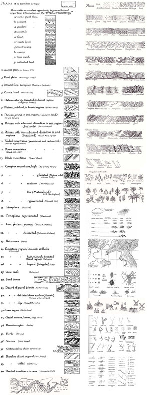
519 followers · 281 posts · Server mstdn.socialHow to draw various #landforms, from "Principles of Cartography" (1962) by Erwin Raisz 🌋⛰🏞🏜🌄
GregCocks · @GregCocks
60 followers · 71 posts · Server techhub.socialGeologic Map Of The Source Region Of Shalbatana Vallis, Mars
--
https://doi.org/10.3133/sim3492 <-- publication
--
https://pubs.usgs.gov/sim/3492/sim3492_pamphlet.pdf <-- phamplet
--
https://pubs.usgs.gov/sim/3492/sim3492_sheet.pdf <-- high resolution map
--
https://pubs.usgs.gov/sim/3492/sim3492_XantheTerra_GISFiles.zip <-- GIS files for download
--
#GIS #spatial #mapping #gischat #map #Mars #solarsystem #elevation #geology #geomorphology #XantheTerra #download #GISData #opendata #landforms #geologicmapping #geological #hydrology #water #flood #flooding #extraterrestrial #remotesensing #THEMIS #satellite #orbiter
#USGS
#gis #spatial #mapping #gischat #map #Mars #solarsystem #elevation #geology #geomorphology #xantheterra #download #gisdata #opendata #landforms #geologicmapping #geological #hydrology #water #flood #flooding #Extraterrestrial #remotesensing #themis #satellite #orbiter #usgs
BTU Geopedology · @BTU_Geopedology
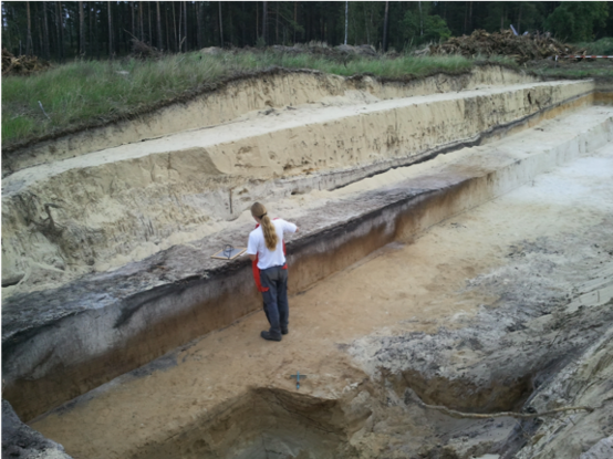
35 followers · 12 posts · Server mastodon.worldGeopedology@BTU is now on Mastodon. We study #soils and #landforms in the earth‘s critical zone - properties, distribution, genesis, functions. Looking forward joining news about #soil #pedology #environment #geology #geomorphology #archaeology #geoarchaeology #Quaternary #Holocene #Anthropocene
#soils #landforms #soil #pedology #environment #geology #geomorphology #archaeology #geoarchaeology #Quaternary #Holocene #anthropocene


