
Bill · @bil
657 followers · 596 posts · Server vis.social

Katarzyna Ewa Lewińska · @kelewinska
24 followers · 11 posts · Server mapstodon.space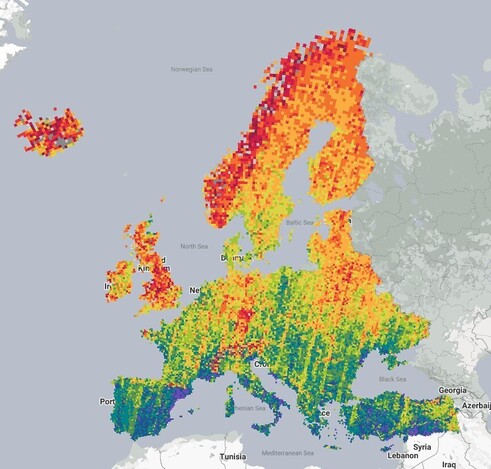
Have you ever wondered what is the availability of cloud-, snow-, and shade-free #Landsat and #Sentinel2 🛰️observations over Europe? Ponder no more: https://katarzynaelewinska.users.earthengine.app/view/europedataval; #preprint: https://preprints.org/manuscript/202308.2174
P.S. the World-wide analysis is coming shortly

AI6YR · @ai6yr
4780 followers · 32900 posts · Server m.ai6yr.org
HagollEO · @ohagolle
235 followers · 87 posts · Server fediscience.org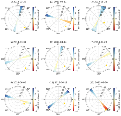
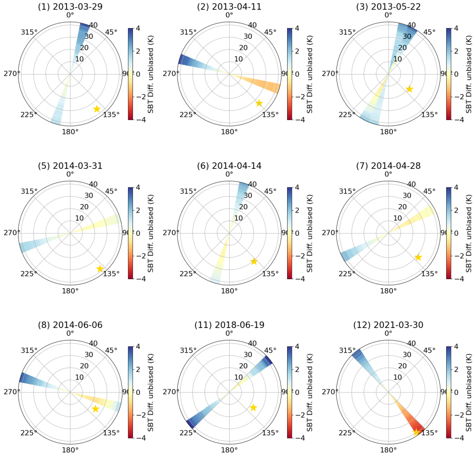
New paper ! We measured expected directional effects on thermal infrared satellite images from #TRISHNA, #LSTM or #SBG missions, using simultaneous acquisitions from #LANDSAT and an aerial imager #MASTER from @NASAJPL
Differences up to 4.5 degrees in #TRISHNA field of view have been observed, which can be corrected to less than 2°K using very simple models.
For more details and to access the paper : https://labo.obs-mip.fr/multitemp/hr-tir-da-irl-high-resolution-thermal-infra-red-directional-anisotropy-in-real-life/
#master #landsat #SBG #LSTM #Trishna

Luca Congedo · @lucacongedo_gis
41 followers · 6 posts · Server fosstodon.orgRoad to the Semi-Automatic Classification Plugin v.8 for #QGIS
-updated tool for downloading #NASA Harmonized #Landsat and #Sentinel-2 images, as well as #Copernics Sentinel-2 images.
-unified interface for preprocessing #remotesensing images
-updated classification tool including #machinelearning learning algorithms: Multi-Layer Perceptron, Support Vector Machine, and Random Forest through #scikitlearn and #PyTorch
#qgis #nasa #landsat #sentinel #copernics #remotesensing #machinelearning #scikitlearn #pytorch

Mike Mahoney · @MikeMahoney218
774 followers · 885 posts · Server fosstodon.org📣 Very excited to see this paper -- led by Lucas Johnson with Madeleine Desrochers and Colin Beier -- officially published!
Using #Landsat imagery and #MachineLearning tools, we estimate forest biomass across New York State from 1990 - 2019. These #maps will help us quantify how much carbon is stored in forests across the state, how that's changed in 30 years, and how we can expect that to change into the future.
https://www.sciencedirect.com/science/article/pii/S0378112723005820
#landsat #machinelearning #maps #openaccess #remotesensing #gischat

NASA · @nasa
65004 followers · 7274 posts · Server social.beachcom.org
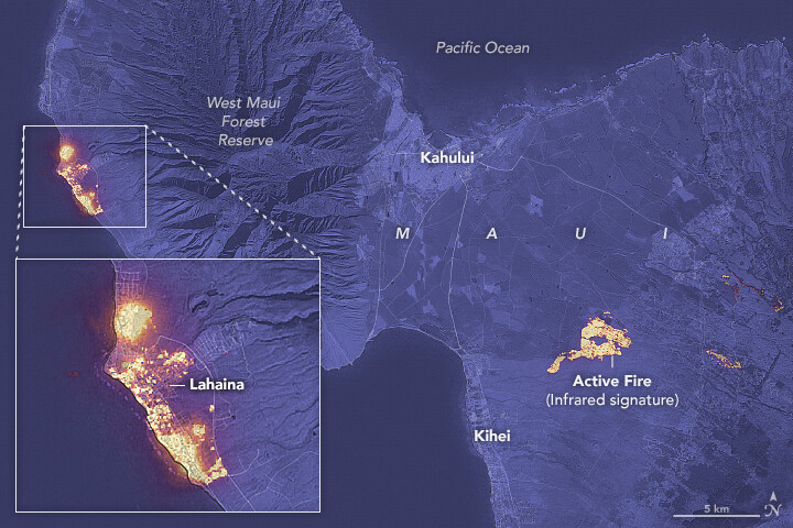
A fast-moving wildfire in Maui occurred during a period of strong winds and dry conditions. In this #Landsat 8 image from Aug. 8, infrared light shows the locations of active fires in yellow. The fires burned in the town of Lahaina and northwest of Kihei. https://go.nasa.gov/3OSyJPU
#NASAEarth

Santiago Gassó · @SanGasso
374 followers · 293 posts · Server airpollution.science
Actually there was a nice #Landsat overpass .
The standard RGB shows no obvious plume coming from the #volcano at the time of the overpass, and nothing obvious in the more general view .
But when looking at the NIR composite, there is a distinctive track of brighter clouds
(#volcanotrack) which is a telltale of clouds contaminated by the volcano.
This coincides with the similar picture taken by the #MODIS
sensor, which has coarser resolution.
#landsat #volcano #volcanotrack #MODIS #nasaearth #atmosphere
NASA · @nasa
74899 followers · 7185 posts · Server social.beachcom.org
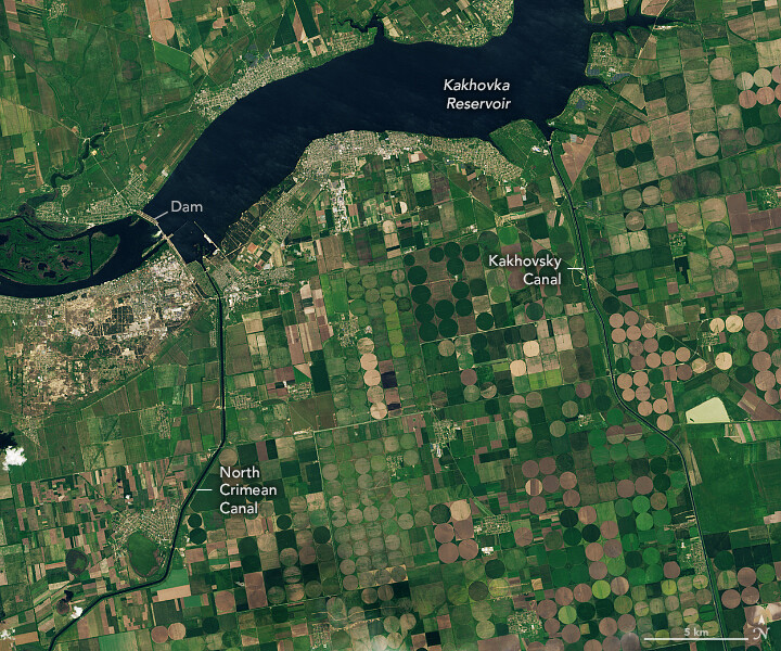
After the breach of Kakhovka Dam in June 2023, the adjacent reservoir drained, leaving farmers in southern Ukraine to cope with depleted water supplies.
These #Landsat images show the reservoir and two canals before (left) and after (right) the breach. https://go.nasa.gov/3Yh4rt2
#NASAEarth
Luca Congedo · @lucacongedo_gis
20 followers · 4 posts · Server fosstodon.orgThe Semi-Automatic Classification Plugin for #qgis will be released in October 2023.
This new version will improve the capabilities of Semi-Automatic Classification Plugin, based on a completely new #python processing framework that is Remotior Sensus, developed for image classification such as #landsat #sentinel2 , #machinelearning and #gis spatial analyses.
https://fromgistors.blogspot.com/2023/07/Semi-AutomaticClassificationPluginReleaseDate.html
#qgis #python #landsat #sentinel2 #machinelearning #gis
NASA · @nasa
74013 followers · 7098 posts · Server social.beachcom.orgNow, Landsat Next is on the horizon 🌅
With a trio of smaller satellites that can each detect 26 wavelengths of light and thermal energy,
@nasa/@USGS #Landsat Next will provide finer resolution and more frequent data to monitor Earth’s changing surface. http://go.nasa.gov/3va23GU
[Video embedded in original tweet]
#NASAEarth
NASA · @nasa
74013 followers · 7097 posts · Server social.beachcom.org
Together, OLI and TIRS study all parts of Earth’s surface every 16 days.
From land to ice to sea, the open data provided by the #Landsat program has contributed to a deeper understanding of our changing planet. #OpenScience
#NASAEarth
#landsat #openscience #nasaearth
NASA · @nasa
73990 followers · 7095 posts · Server social.beachcom.org
#Landsat 8 and 9 also measure land surface temperature with Thermal Infrared Sensor (TIRS) and TIRS-2. These data are crucial for water management and ice detection.
#DYK that TIRS almost didn’t exist? Now it’s been imaging Earth for over a decade! http://go.nasa.gov/3OSCDbH
#NASAEarth
NASA · @nasa
73990 followers · 7093 posts · Server social.beachcom.org
51 years of eyes on Earth 👀🛰
Since 1972, the #Landsat program has been studying Earth’s land, water, ice and more.
There are currently three active @nasa @usgs Landsat satellites orbiting Earth — Landsat 7, 8, and 9 — with Landsat Next on the horizon. http://go.nasa.gov/3Nxxl4w
#NASAEarth
AI6YR · @ai6yr
4209 followers · 25866 posts · Server m.ai6yr.org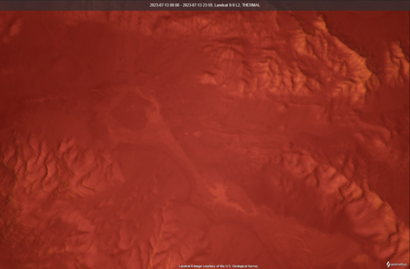
#Landsat Thermal view of Death Valley National Park. Just realized you fan use the thermal satellite sensors to determine where is likely to be the hottest part of the park, based on thermal signature from other days. (ie if you REALLY want to experience 131F, probably localized microcclimate)
NASA · @nasa
73402 followers · 7059 posts · Server social.beachcom.org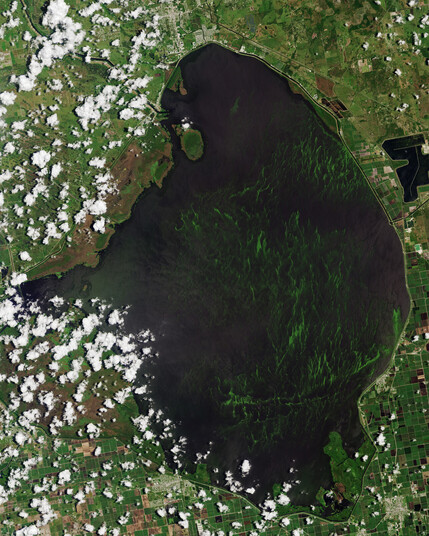
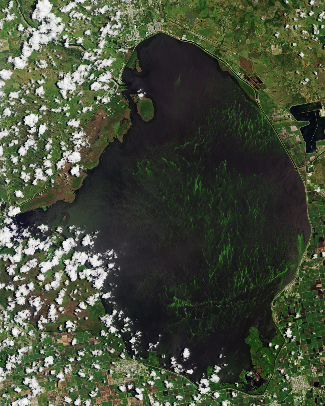
Algae has covered about half of Florida’s largest freshwater lake, Lake Okeechobee, for much of June and early July 2023.
The @nasa/@usgs #Landsat 9 satellite captured this image of the algae bloom on June 12, which is producing harmful toxins. https://go.nasa.gov/44qmL5a
#NASAEarth
NASA · @nasa
72981 followers · 7074 posts · Server social.beachcom.org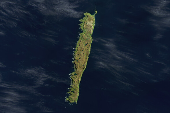
Pitstop ahead ✅
Macquarie Island, located halfway between Australia and Antarctica, has been an important stopping place for Antarctic explorers and breeding populations of penguins and seals. 🐧
#Landsat 9 captured this image in 2022. https://go.nasa.gov/44GtNCu
#NASAEarth
NASA · @nasa
69049 followers · 7070 posts · Server social.beachcom.orgHappy #NationalCameraDay! While not a camera per se, #Landsat’s OLI instrument captures beautiful images of our planet. 🌍
The imager on the upcoming Landsat Next satellites will see changes on Earth’s surface with more precise detail than ever before. https://go.nasa.gov/3CSga7v
#NASAEarth
#NationalCameraDay #landsat #nasaearth

Jonathan Reeve Price · @jonathanreeveprice
20 followers · 149 posts · Server newsie.social
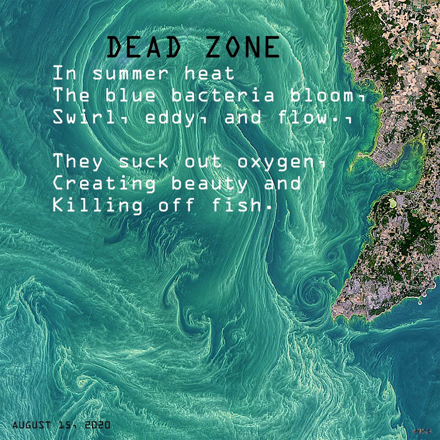
Dead Zone The Baltic Sea around the island of Gotland, seen from Landsat 8. #climate #warming #heat #summer #Baltic #Landsat #visualpoem #digitalpoem
https://oceancolor.gsfc.nasa.gov/gallery/717/
https://en.wikipedia.org/wiki/Cyanobacteria
#climate #warming #heat #summer #baltic #landsat #visualpoem #digitalpoem
NASA · @nasa
68916 followers · 7062 posts · Server social.beachcom.orgThe findings come from a study using #Landsat data to quantify flooding in 316 ponds in the area from 1985-2018. The team used other data to model how much flooding was due to climatic versus anthropogenic factors.
#NASAEarth