
Jáchym Brzezina · @jachym
222 followers · 105 posts · Server mastodonczech.cz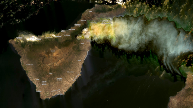
Ostrov Tenerife, tak jak ho viděla americká družice #Landsat8 16. srpna 2023. V severovýchodní části ostrova je vidět rozsáhlý kouř z lesních požárů. Požár je dobře patrný i na dalším snímku ze stejného dne a družice, který ukazuje teplotu.
#landsat8 #tenerife #pozar #druzice
Die_Primel · @Die_Primel
396 followers · 11862 posts · Server det.socialRT @i_ameztoy
2/n. 🧵 #IFVillanuevaViver 🔥 Así se veían las columnas de humo al sureste de la zona afectada. Además, si lo miramos con los canales infrarojos y lo sobreponemos sobre la imagen visible, podemos ver dónde se encuentra el frente de llamas ❤️🔥
Imagen #Landsat8 🛰️ 2023-03-25

GregCocks · @GregCocks
161 followers · 182 posts · Server techhub.social
Release Of LGRIP30 Data Product [USGS/NASA]
--
https://lpdaac.usgs.gov/news/release-of-lgrip30-data-product/ <-- press release
--
https://doi.org/10.5067/Community/LGRIP/LGRIP30.001 <-- overview
--
https://www.usgs.gov/apps/croplands/app/map <-- web map/ data portal
--
#GIS #spatial #mapping #water #remotesensing #Landsat #opendata #LGRIP #watersecurity #foodsecurity #global #cropland #climatechange #cropland #irrigation #agriculture #LGRIP30 #GlobalFoodSecurity #GFSAD #rainfed #Landsat8 #satellite #hydrology #food
#NASA #USGS
#gis #spatial #mapping #water #remotesensing #landsat #opendata #lgrip #watersecurity #FoodSecurity #global #cropland #climatechange #irrigation #agriculture #lgrip30 #globalfoodsecurity #gfsad #rainfed #landsat8 #satellite #hydrology #Food #NASA #usgs

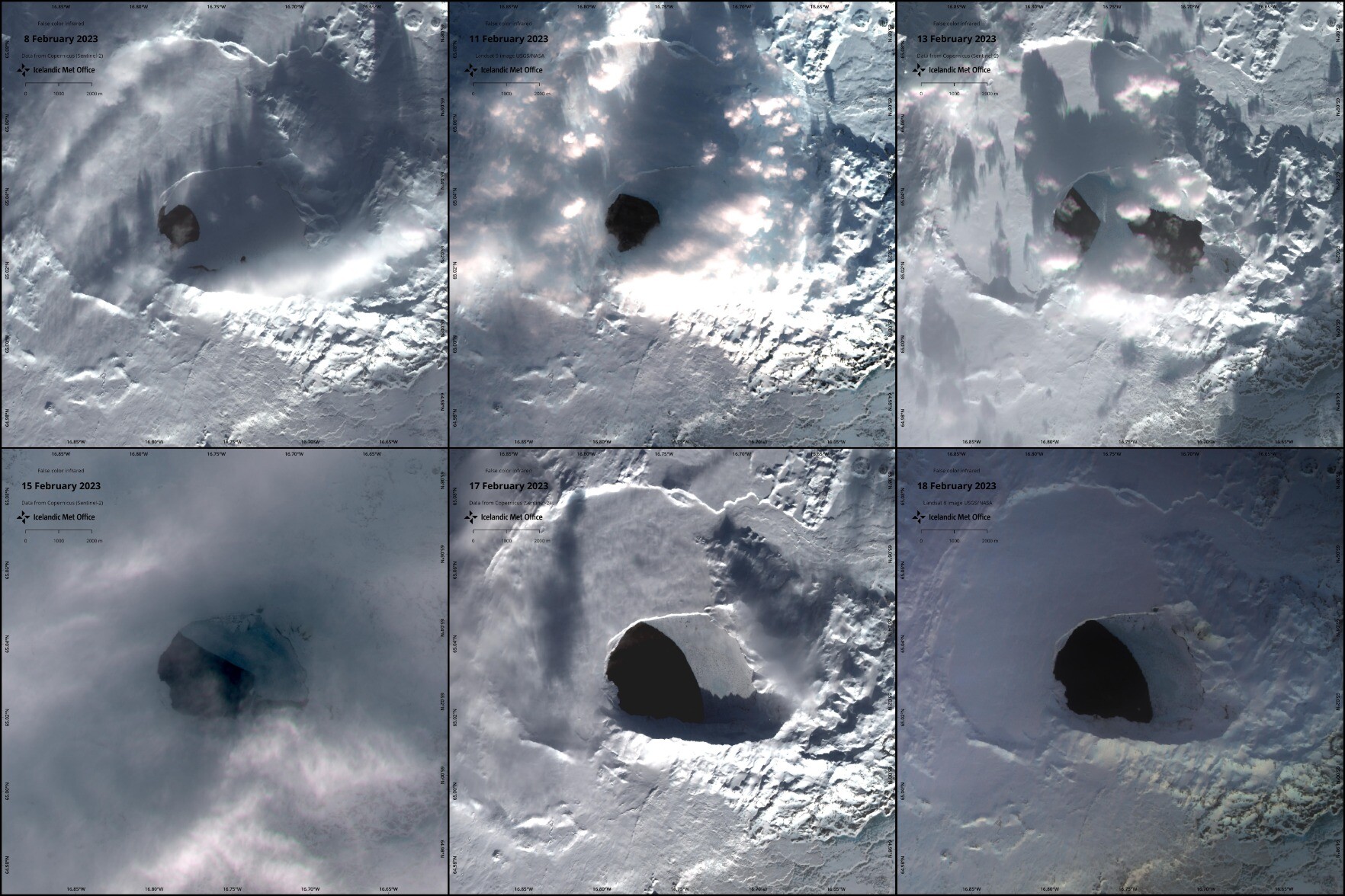
Ragnar Heiðar Þrastarson · @RagnarHeidar
163 followers · 46 posts · Server mastodon.social
While keeping a close eye on #Askja caldera, let’s not forget just how amazing it is to have access to free satellite data, that has enough temporal and spatial coverage to deliver 6 images in the span of 10 days! #sentinel2 #landsat8 #landsat9
❤️ USGS/NASA
❤️ @CopernicusEU
#Askja #sentinel2 #landsat8 #Landsat9

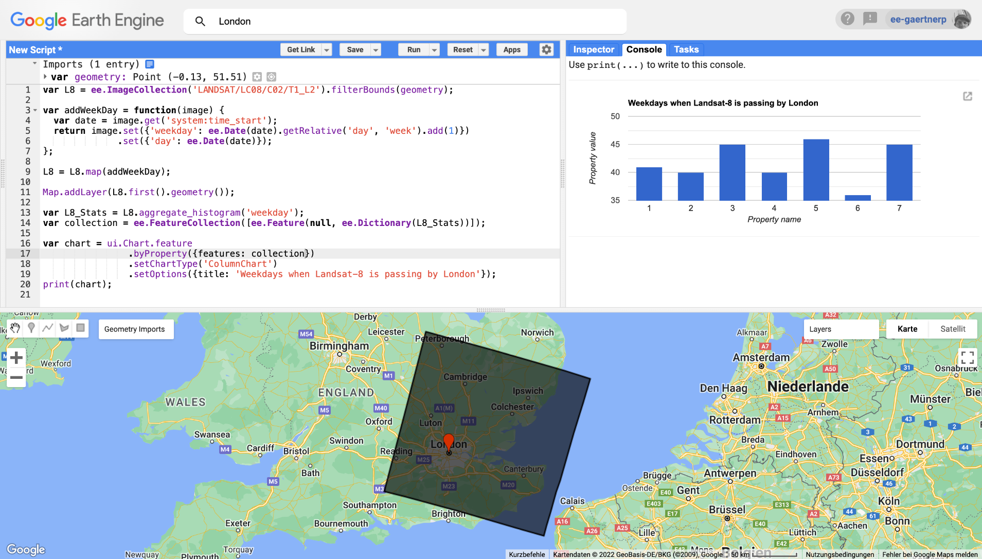
Philipp Gärtner · @Mixed_Pixels
150 followers · 20 posts · Server mapstodon.space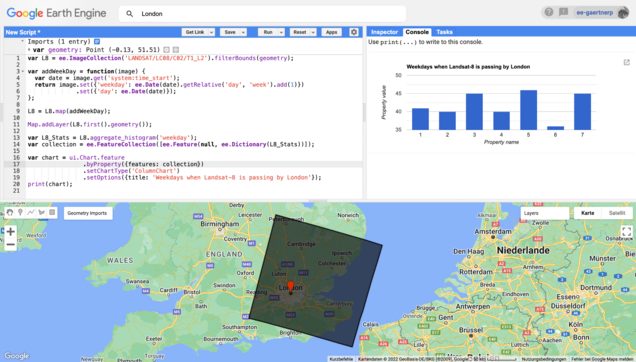
I was actually looking for something else but accidentally found out, that #Landsat8 🛰️ is (often) avoiding #London on Saturdays. 💂🇬🇧📅 :gearth_engine:
https://code.earthengine.google.com/3c1090e1fce32e4b3f8827f63aad4475

Geography With Justin · @GeoWithJustin
31 followers · 12 posts · Server mapstodon.space
Day 26 - Islands
The artificial islands of the UAE 🇦🇪
🛰️ #Landsat8
#30DayMapChallenge
(I hope the Arabic is correct)

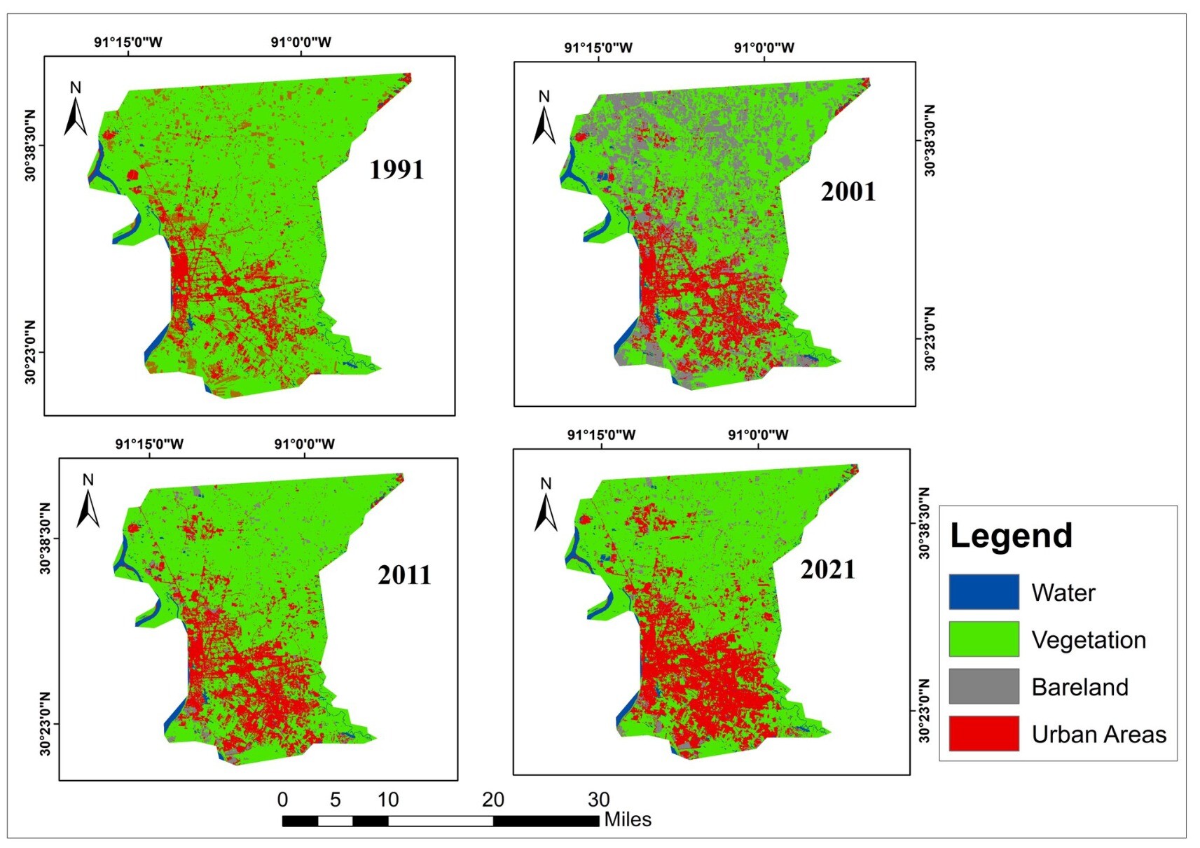
Ladies of Landsat · @LadiesOfLandsat
209 followers · 15 posts · Server mapstodon.space
Diana E. Frimpong et al. (2022) assessed the relationship between land use land cover #LULC change & air quality trends over the past 30 years in East Baton Rouge, Louisiana using #Landsat5 & #Landsat8 imagery, #Sentinel5p & air quality index from the EPA. #LoLManuscriptMonday https://bit.ly/Frimpong_2022
Cheers to Diana’s co-authors and affiliated organizations for this manuscript, and thank you especially to our lead Matilda Anokye for leading this Manuscript Monday feature! #EOChat #GISChat
#lulc #Landsat5 #landsat8 #Sentinel5P #LoLManuscriptMonday #eochat #gischat

☆joene☆ · @joenepraat
1245 followers · 20325 posts · Server todon.nl
👇
---
RT @i_ameztoy
‼️ Extra/Actualización 🛰️🌋 2021-09-26 11:42 UTC
Si ayer la #Sentinel2👆nos ofrecía una imagen espectacular, hoy #Landsat8 nos permite ver la colada en todo su esplendor. Falso Color (764). Pronto video!
Full Size-> https://flic.kr/p/2muFKuK🧐
#LaPalma #volcanCumbreVieja #scicomm
https://twitter.com/i_ameztoy/status/1442150010049622021
#scicomm #volcanCumbreVieja #lapalma #landsat8 #sentinel2