GregCocks · @GregCocks
718 followers · 569 posts · Server techhub.socialExtensibility Of U-Net Neural Network Model For Hydrographic Feature Extraction And Implications For Hydrologic Modeling
--
https://doi.org/10.3390/rs13122368 <-- shared paper
--
#GIS #spatial #mapping #machinelearning #neuralnetwork #Unet #featureextraction #hydrography #hydrology #water #automation #remotesensing #surfacewater #NHD #bluelines #topography #deeplearning #AI #artificialintelligence #LiDAR #ifSAR #elevation #topography #ANN #HPC #model #modeling #trainingdata #Alaska #USA #watersheds #DTM #DSM #DEM #routing #network #D8 #maps #opendata #3dep #elevation #topography #USGS
#gis #spatial #mapping #machinelearning #neuralnetwork #unet #featureextraction #hydrography #hydrology #water #automation #remotesensing #surfacewater #nhd #bluelines #topography #deeplearning #AI #artificialintelligence #lidar #ifsar #elevation #ann #hpc #model #modeling #trainingdata #alaska #USA #watersheds #dtm #dsm #dem #routing #network #d8 #Maps #opendata #3dep #usgs
Randal Hale · @rjhale1971
548 followers · 695 posts · Server fosstodon.org@kgjenkins Find a Quarry - see if it's covered. They have point clouds and bare earth DEMS.
https://apps.nationalmap.gov/lidar-explorer/#/ #lidar
JensWiesehahn · @JensWiesehahn
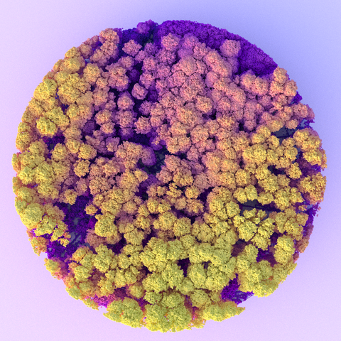
281 followers · 178 posts · Server fosstodon.orgI did some visualizations for a presentation on the topic of forest disturbances and ALS data. Combining two of my favourite R packages, *lidR* and *rayrender*.
#rstats #lidar #forests #lidr #rayrender
JensWiesehahn · @JensWiesehahn
281 followers · 178 posts · Server fosstodon.orgGave a short presentation about ALS data and forest disturbances at #silvilaser23 conference yesterday.
Slides available at https://github.com/wiesehahn/presentation-silvilaser23
You can also watch all presentations at https://blogs.ucl.ac.uk/silvilaser2023/
#silvilaser23 #lidar #als #quarto #revealjs
· @NaturalNews
6258 followers · 32363 posts · Server brighteon.socialPretty cool what #lidar #lasers can do!
https://www.naturalnews.com/2023-09-05-six-ancient-civilizations-discovered-lidar-lasers.html
#lidar #lasers #ancientcivilizations
Mattia Bunel · @mattiabunel
167 followers · 33 posts · Server framapiaf.orgHuitième et dernière intervention: #Spark et son écosystème pour le traitement distribué de données #lidar, par @mattiabunel
Mattia Bunel · @mattiabunel
167 followers · 32 posts · Server framapiaf.orgSixième intervention: #LidarView : A #Paraview based application for #Lidar data Visualization and Processing, par Gatien Ferret (Kitware Europe)
Mattia Bunel · @mattiabunel
167 followers · 32 posts · Server framapiaf.orgCinquième intervention: Présentation de #CloudCompare, projet Open Source pour le traitement des nuages de points 3D, par Daniel Girardeau #lidar #FOSS
Mattia Bunel · @mattiabunel
167 followers · 28 posts · Server framapiaf.org🙃 ɐıunp zsɐɯoʇ :idle: · @to3k
987 followers · 2969 posts · Server mastodon.tomaszdunia.plIt’s too early for an autonomous driving. Especially that lately we have only bad information and negative opinions on this topic.
———
#Bosch gives up on #LiDAR development effort #TDBNews https://nordot.app/1069989202147591061
GregCocks · @GregCocks
612 followers · 555 posts · Server techhub.socialASPRS Approves Edition 2 of the ASPRS Positional Accuracy Standards for Digital Geospatial Data
--
https://www.asprs.org/revisions-to-the-asprs-positional-accuracy-standards-for-geospatial-data-2023 <-- shared technical article
--
https://publicdocuments.asprs.org/PositionalAccuracyStd-Ed2-V1 <-- download the current ASPRS current document
--
#GIS #spatial #mapping #gischat #ASPRS #precision #accuracy #standards #data #spatialdata #PositionalAccuracyStandards #survey #surveying #workinggroup #confidencelevel #metrics #measurement #checkpoints #groundcontrol #VWA #remotesensing #LiDAR #3dmapping #UAS #photogrammetry #geomorphometry
#gis #spatial #mapping #gischat #asprs #precision #accuracy #Standards #data #spatialdata #positionalaccuracystandards #survey #surveying #workinggroup #confidencelevel #metrics #measurement #checkpoints #groundcontrol #vwa #remotesensing #lidar #3dmapping #uas #photogrammetry #geomorphometry
Delta Wye ✳️ CLEVELAND · @DeltaWye
111 followers · 2110 posts · Server mstdn.socialRawr! (3D scan of a bronze wolf’s head, 1-100AD, Rome, Italy.) Meshroom did a pretty decent job with the camera and #lidar. I think this is the first video I’ve uploaded to Mastodon.
#archaeology #iPhone14Pro #scaniverse #3dscan #lidar
Bose-Einstein-Kondensat · @MWNautilus
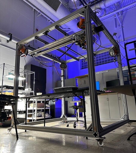
111 followers · 16 posts · Server mstdn.social#SPOT: #OpenSource Scanning Plant #IoT facility for mobile high-throughput #plant #phenotyping:
-10x10 ft scanning region
-hyperspectral sensor
-thermal camera
-#LiDAR camera
-#Arduino- & #Python-controlled
https://www.sciencedirect.com/science/article/pii/S2468067223000755
#DIYbio #biohacking #lab #instruments #imaging
#imaging #instruments #lab #biohacking #diybio #Python #Arduino #lidar #phenotyping #plant #IOT #OpenSource #spot
J9Cody :arcgis: :python: 🛰️ · @J9C
84 followers · 86 posts · Server mapstodon.spaceA new topobathymetric lidar dataset for the Potomac River from the #USGS 3D Elevation Program (3DEP) is available for download. Uses: estimating concentrations of contaminant plumes; engineering for bridges and roads; mapping aquatic habitats for biological assessments; and flood mapping.
https://www.usgs.gov/news/technical-announcement/new-usgs-national-map-data-reveals-potomac-rivers-submerged-topography
#ICPRB #potomacriver #3dep #lidar #gischat #bathymetry #TopographyTuesday
#USGS #icprb #potomacriver #3dep #lidar #gischat #bathymetry #topographytuesday
GregCocks · @GregCocks
608 followers · 551 posts · Server techhub.socialNew USGS National Map Data Reveals The Potomac River’s Submerged Topography
--
https://www.usgs.gov/news/technical-announcement/new-usgs-national-map-data-reveals-potomac-rivers-submerged-topography <-- shared technical article
--
#GIS #spatial #mapping #remotesensing #LiDAR #opendata #HarpersFerry #westvirginia #virginia #USA #potomac #river #water #hydrology #hydrospatial #TheNationalMap #USGS #ICPRB #bathymetry #topobathy #elevation #3dep #3dntm #inflationreductionact #riverflow #appliedscience #model #modeling #fateandtransport #waterquality #waterresources #waterresourcemanagement #engineering #infrastructure #transportation #usecase #ecosystems #environment
@usgs
#gis #spatial #mapping #remotesensing #lidar #opendata #harpersferry #westvirginia #virginia #USA #potomac #river #water #hydrology #hydrospatial #thenationalmap #usgs #icprb #bathymetry #topobathy #elevation #3dep #3dntm #inflationreductionact #riverflow #appliedscience #model #modeling #fateandtransport #waterquality #waterresources #waterresourcemanagement #engineering #infrastructure #transportation #usecase #ecosystems #Environment
Daniele Neander Mancini · @dannyplayes
0 followers · 10 posts · Server mastodon.unoRETE STRADALE ROMANA IDENTIFICATA CON LiDAR IN CORNOVAGLIA https://www.danielemancini-archeologia.it/rete-stradale-romana-identificata-con-lidar-in-cornovaglia/ #CésarParceroOubiña, #ChristopherSmart, #JoãoFonte, #LIDAR, #RemoteSensing, #ReteStradaleRomana, #UniversitàDiExeter
#lidar #remotesensing #retestradaleromana #cesarparcerooubina #christophersmart #joaofonte #universitadiexeter
GregCocks · @GregCocks
590 followers · 527 posts · Server techhub.socialField-Based Monitoring Of Instream Leaky Barrier Backwater And Storage During Storm Events
--
https://www.sciencedirect.com/science/article/pii/S0022169423006868 <-- shared paper
--
#GIS #spatial #mapping #remotesensing #NaturalFloodManagement #LeakyBarrier #FloodAttenuation #BackwaterRise #BarrierStorage #model #modeling #monitoring #flood #flooding #UK #England #Britian #photogrammetry #DEM #DTM #LiDAR #water #hydrology #extremeweather #climatechange #waterstorage #waterresources #watermanagement #storm #waterquality #ecosystem #benefits #engineering #infrastructure #transducers #streamflow #backwater #rainfall #precipitatiion #overbank #flow #innundation #floodmodeling
#gis #spatial #mapping #remotesensing #naturalfloodmanagement #leakybarrier #floodattenuation #backwaterrise #barrierstorage #model #modeling #monitoring #flood #flooding #uk #england #britian #photogrammetry #dem #dtm #lidar #water #hydrology #extremeweather #climatechange #waterstorage #waterresources #watermanagement #storm #waterquality #ecosystem #benefits #engineering #infrastructure #transducers #streamflow #backwater #rainfall #precipitatiion #overbank #flow #innundation #floodmodeling
apfeltalk :verified: · @apfeltalk
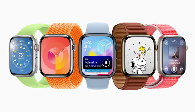
1181 followers · 794 posts · Server creators.socialKünftige Apple Watch könnte sich automatisch an Farben anpassen
Apple untersucht akt
https://www.apfeltalk.de/magazin/news/kuenftige-apple-watch-koennte-sich-automatisch-an-farben-anpassen/
#News #Watch #ElectronicDevicesWithColorSamplingSensors #Algorithmen #AppleVisionPro #AppleWatch #Armbnder #Benutzerwahl #BlauesLicht #Display #ExterneObjekte #Farbanpassung #Farbpalette #Farbsensor #GrnesLicht #Kleidung #Lidar #NicolasPBonnier #Patent #Reflektanz #RotesLicht #Sensoren #Ziffernblatt
#News #watch #electronicdeviceswithcolorsamplingsensors #algorithmen #applevisionpro #applewatch #armbnder #benutzerwahl #blaueslicht #display #externeobjekte #farbanpassung #farbpalette #farbsensor #grneslicht #kleidung #lidar #nicolaspbonnier #patent #reflektanz #roteslicht #sensoren #ziffernblatt


