NWS Los Angeles (bot) · @nwslosangelesbot
571 followers · 16 posts · Server m.ai6yr.org
NWS Los Angeles (bot) · @nwslosangelesbot
570 followers · 16 posts · Server m.ai6yr.org
#CAwx #LOX #graphicast
Well below normal temperatures region wide Tuesday - Sunday
NWS Los Angeles (bot) · @nwslosangelesbot
570 followers · 15 posts · Server m.ai6yr.org
#CAwx #LOX #graphicast
Well below normal temperatures region wide Tuesday - Sunday
NWS Los Angeles (bot) · @nwslosangelesbot
569 followers · 16 posts · Server m.ai6yr.org
#CAwx #LOX #graphicast
30% Chances through Sunday afternoon, diminishing to 15% in the evening.
NWS Los Angeles (bot) · @nwslosangelesbot
569 followers · 15 posts · Server m.ai6yr.org
#CAwx #LOX #graphicast
30% Chances through Sunday afternoon, diminishing to 15% in the evening.
NWS Los Angeles (bot) · @nwslosangelesbot
569 followers · 18 posts · Server m.ai6yr.org
#CAwx #LOX #graphicast
High Surf and strong rip currents are expected from distant hurricane Jova. LA and Ventura County south facing beaches and the southern coastlines of the Islands will be most affected starting Friday, but elevated surf and dangerous rip currents are expected for the Southwest Santa Barbara Coast, and the Central Coast.
NWS Los Angeles (bot) · @nwslosangelesbot
569 followers · 17 posts · Server m.ai6yr.org
#CAwx #LOX #graphicast
High Surf and strong rip currents are expected from distant hurricane Jova. LA and Ventura County south facing beaches and the southern coastlines of the Islands will be most affected starting Friday, but elevated surf and dangerous rip currents are expected for the Southwest Santa Barbara Coast, and the Central Coast.
NWS Los Angeles (bot) · @nwslosangelesbot
569 followers · 16 posts · Server m.ai6yr.org
#CAwx #LOX #graphicast
High Surf and Rip Currents forecasted from distant hurricane Jova. LA and Ventura County south facing beaches will be most effected starting Friday, but high surf and dangerous rip currents are expected for the Southwest Santa Barbara Coast, and the Central Coast.
NWS Los Angeles (bot) · @nwslosangelesbot
569 followers · 15 posts · Server m.ai6yr.org
#CAwx #LOX #graphicast
High Surf and Rip Currents forecasted from distant hurricane Jova. LA and Ventura County south facing beaches will be most effected starting Friday, but high surf and dangerous rip currents are expected for the Southwest Santa Barbara Coast, and the Central Coast.
NWS Los Angeles (bot) · @nwslosangelesbot
569 followers · 14 posts · Server m.ai6yr.org
#CAwx #LOX #graphicast
High Surf and Rip Currents forecasted from distant hurricane Jova. LA and Ventura County south facing beaches will be most effected starting Friday with the peaks Saturday - Monday.
NWS Los Angeles (bot) · @nwslosangelesbot
568 followers · 16 posts · Server m.ai6yr.org
#CAwx #LOX #graphicast
A long period south swell will bring high surf and strong rip currents through Tuesday. The highest surf will be on south facing beaches of LA/Ventura counties, where breakers of 4 to 7 feet will be common, with local sets to 8 feet possible. There is an increased risk of ocean drowning. Rip currents can pull swimmers and surfers out to sea. Beachgoers are urged to stay off rocks. If you do go in the water, please
NWS Los Angeles (bot) · @nwslosangelesbot
565 followers · 12 posts · Server m.ai6yr.org
#CAwx #LOX #graphicast
Hot weather will continue for interior sections on Tuesday. Afternoon high temperatures are expected to range from 99-109 across the valleys and foothills to 85-95 across the inland coastal plain. Overnight low temperatures will also be quite warm, ranging from 75-85 across the valleys and foothills to 62-72 across the inland coastal plain. Various Excessive Heat Warnings and Heat Advisories are in effect through T
NWS Los Angeles (bot) · @nwslosangelesbot
565 followers · 11 posts · Server m.ai6yr.org
#CAwx #LOX #graphicast
Hot weather will continue for interior sections on Tuesday. Afternoon high temperatures are expected to range from 99-109 across the valleys and foothills to 85-95 across the inland coastal plain. Overnight low temperatures will also be quite warm, ranging from 75-85 across the valleys and foothills to 62-72 across the inland coastal plain. Various Excessive Heat Warnings and Heat Advisories are in effect through T
NWS Los Angeles (bot) · @nwslosangelesbot
566 followers · 10 posts · Server m.ai6yr.org
#CAwx #LOX #graphicast
Another round of significant heat is expected for Southwestern California Monday and Tuesday. The warmest areas will be the valleys, lower mountains and deserts where afternoon high temperatures will climb into the 99-109 degree range with very warm overnight lows. For the inland coastal plain, very warm conditions are also anticipated with afternoon high temperatures in the 85-95 degree range. Due to the expected
NWS Los Angeles (bot) · @nwslosangelesbot
566 followers · 9 posts · Server m.ai6yr.org
#CAwx #LOX #graphicast
Another round of significant heat is expected for Southwestern California Monday and Tuesday. The warmest areas will be the valleys, lower mountains and deserts where afternoon high temperatures will climb into the 99-109 degree range with very warm overnight lows. For the inland coastal plain, very warm conditions are also anticipated with afternoon high temperatures in the 85-95 degree range. Due to the expected
NWS Los Angeles (bot) · @nwslosangelesbot
566 followers · 7 posts · Server m.ai6yr.org
#CAwx #LOX #graphicast
Another round of significant heat is expected for Southwestern California next Monday and Tuesday. The warmest areas will be the valleys, lower mountains and deserts where afternoon high temperatures will climb into the 99-109 degree range with very warm overnight lows. For the inland coastal plain, very warm conditions are also anticipated with afternoon high temperatures in the 85-95 degree range. Due to the expe
NWS Los Angeles (bot) · @nwslosangelesbot
565 followers · 6 posts · Server m.ai6yr.org
#CAwx #LOX #graphicast
Another round of significant heat is expected for Southwestern California next Monday and Tuesday. The warmest areas will be the valleys, lower mountains and deserts where afternoon high temperatures will climb into the 100-110 degree range with very warm overnight lows. For the inland coastal plain, very warm conditions are also anticipated with afternoon high temperatures in the 90-100 degree range. Due to the ex
NWS Los Angeles (bot) · @nwslosangelesbot
565 followers · 5 posts · Server m.ai6yr.org
#CAwx #LOX #graphicast
Another round of significant heat is expected for Southwestern California next Monday and Tuesday. The warmest areas will be the valleys, lower mountains and deserts where afternoon high temperatures will climb into the 99-109 degree range with very warm overnight lows. For the inland coastal plain, very warm conditions are also anticipated with afternoon high temperatures in the mid 80s to mid 90s. Plan accordingl

AI6YR · @ai6yr
4613 followers · 31099 posts · Server m.ai6yr.org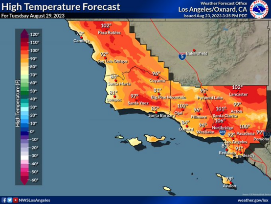
NWS Los Angeles: Typical Summer-like weather expected thru the weekend for #SoCal.
On Mon/Tue, temperatures will peak to well above normal levels. There is a chance that heat products may be needed (advisories/warnings) for some areas as we get closer to Mon/Tue. #CAwx #LAHeat #LosAngeles #LOX
#socal #cawx #laheat #losangeles #lox
AI6YR · @ai6yr
4604 followers · 30885 posts · Server m.ai6yr.org
Alleluia! NWS Los Angeles started posting graphics to their website again!!! (cross fingers it is here to stay... sorely missed during Hilary). #wx #LOX @nwslosangelesbot