Elton Barker · @eltonteb
351 followers · 166 posts · Server hcommons.socialToday you can watch me as I fumble around the digital landscape, using the second-century CE author, Pausanias, as my guide. Join me in person or online at 15:00 BST with @kingsdh 's computational research group, by signing up here: https://kingsdh.net/. It will include live demos (provided I make my sacrifices to the presentation gods).
#map #digitalhumanities #classics #geography #mapping #linkeddata #wikidata
#map #digitalhumanities #classics #geography #mapping #linkeddata #wikidata
arnalie · @arnalielsewhere
64 followers · 63 posts · Server en.osm.townMapping projects here: https://tasks.hotosm.org/explore?campaign=Morocco%20Earthquake%202023
#OpenStreetMap #humanitarian #mapping #humanitarianmapping
War Mapper · @warmapper
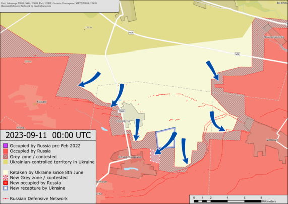
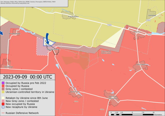
10682 followers · 380 posts · Server mstdn.social🇺🇦 has advanced closer to the edge of Novoprokopoivka, south of Robotyne.
Near Bakhmut, 🇺🇦 has made progress south of Andriivka.
#ukraine #russia #ukrainewar #conflict #map #europe #nato #warinukraine #mapping #news #breaking
#Breaking #News #mapping #WARINUKRAINE #NATO #Europe #Map #conflict #UkraineWar #Russia #Ukraine
GregCocks · @GregCocks
718 followers · 570 posts · Server techhub.socialRecord-Breaking North Atlantic Ocean Temperatures Contribute To Extreme Marine Heatwaves [remote sensing]
--
https://climate.copernicus.eu/record-breaking-north-atlantic-ocean-temperatures-contribute-extreme-marine-heatwaves <-- shared technical article
--
#GIS #spatial #mapping #spatialanalysis #spatiotemporal #climatechange #marine #marineconservation #marinelife #heatwave #NorthAtlantic #MarineHeatwave #fishing #fisheries #fisheriesmanagement #economics #economy #foodsecurity #watertemperature #waterquality #ecosystem #health #ecosystemchange #disease #remotesensing #satellite #climate #Copernicus #ESA @esa
#gis #spatial #mapping #spatialanalysis #spatiotemporal #climatechange #marine #marineconservation #marinelife #heatwave #northatlantic #marineheatwave #fishing #fisheries #fisheriesmanagement #economics #economy #FoodSecurity #watertemperature #waterquality #ecosystem #Health #ecosystemchange #disease #remotesensing #satellite #climate #Copernicus #Esa
GregCocks · @GregCocks
718 followers · 569 posts · Server techhub.socialCoalition For The Poudre River Watershed [Northern Colorado]
--
https://www.poudrewatershed.org/ <-- link to their page
--
https://experience.arcgis.com/experience/c9eac99fff4e4ef18ebaac101ad9a005/ <-- web map
--
“CPRW partners with landowners, government agencies, water utilities, and non-profits to collaboratively address some of the most challenging issues facing our watershed. Together, we identify the biggest problems, use science and expert input to prioritize where our projects will have the most impact and then together, we implement actions on the ground that will protect our rivers, communities, and water supply…”
#GIS #spatial #mapping #webmap #watershed #ecosystem #communityengagement #PoudreRiver #Colorado #NoCo #water #hydrology #volunteer #erosion #wildlife #rivers #forests #communityoutreach #wildfire #fire #CameronPeakFire #recovery #mitigation #ecosystemrestoration #ecosystembuilding #waterresources #waterresourcemanagement #watersupply
#colorado #NoCo #water #hydrology #volunteer #erosion #wildlife #rivers #forests #communityoutreach #wildfire #fire #cameronpeakfire #recovery #mitigation #ecosystemrestoration #ecosystembuilding #waterresources #waterresourcemanagement #watersupply #gis #spatial #mapping #webmap #Watershed #ecosystem #communityengagement #poudreriver
arnalie · @arnalielsewhere
64 followers · 62 posts · Server en.osm.townThank you for contributing and continued support in mapping #Moroccoearthquake2023 affected areas to aid relief efforts.
We still call for mappers and validators to map: https://tasks.hotosm.org/projects/15468
#openstreetmap #humanitarian #humanitarianmapping #mapping #openmapping
#moroccoearthquake2023 #OpenStreetMap #humanitarian #humanitarianmapping #mapping #openmapping
AM_Stark · @123avneesh
4 followers · 27 posts · Server sigmoid.socialVoxblox: Incremental 3D Euclidean Signed Distance Fields for On-Board MAV Planning
Incrementally build Euclidean Signed Distance Fields (ESDF) from truncated SDF (TSDF) using sensor data (depth and position).
My summary on HFPapers: https://huggingface.co/papers/1611.03631#64fdc9579132c7f62a48dbea
arXiv: https://arxiv.org/abs/1611.03631
Bill · @bil
657 followers · 596 posts · Server vis.socialPlenty of mapping to be done in support of the response to the earthquake near Marrakesh: https://tasks.hotosm.org/projects/15468 #mapping #morocco #hotosm
War Mapper · @warmapper
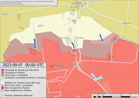
10647 followers · 378 posts · Server mstdn.social🇺🇦 has advanced into the north of Novomaiors'ke, the settlement is now contested. (East of the attempted advance near Novodonets'ke)
In the Robotyne area, 🇺🇦 has expanded its control between Novoprokopivka and Verbove.
#ukraine #russia #ukrainewar #conflict #map #europe #nato #warinukraine #mapping #news #breaking
#Breaking #News #mapping #WARINUKRAINE #NATO #Europe #Map #conflict #UkraineWar #Russia #Ukraine
War Mapper · @warmapper
10642 followers · 377 posts · Server mstdn.socialA map of the approximate situation on the ground in Ukraine as of 00:00 UTC 08/09/23.
There have been no notable changes to control confirmed since the last update.
After increased shelling in recent days, Ukraine is attempting to advance near Novodonets'ke.
#ukraine #russia #ukrainewar #conflict #map #europe #nato #warinukraine #mapping #news #breaking
#Breaking #News #mapping #WARINUKRAINE #NATO #Europe #Map #conflict #UkraineWar #Russia #Ukraine
GregCocks · @GregCocks
718 followers · 569 posts · Server techhub.socialExtensibility Of U-Net Neural Network Model For Hydrographic Feature Extraction And Implications For Hydrologic Modeling
--
https://doi.org/10.3390/rs13122368 <-- shared paper
--
#GIS #spatial #mapping #machinelearning #neuralnetwork #Unet #featureextraction #hydrography #hydrology #water #automation #remotesensing #surfacewater #NHD #bluelines #topography #deeplearning #AI #artificialintelligence #LiDAR #ifSAR #elevation #topography #ANN #HPC #model #modeling #trainingdata #Alaska #USA #watersheds #DTM #DSM #DEM #routing #network #D8 #maps #opendata #3dep #elevation #topography #USGS
#gis #spatial #mapping #machinelearning #neuralnetwork #unet #featureextraction #hydrography #hydrology #water #automation #remotesensing #surfacewater #nhd #bluelines #topography #deeplearning #AI #artificialintelligence #lidar #ifsar #elevation #ann #hpc #model #modeling #trainingdata #alaska #USA #watersheds #dtm #dsm #dem #routing #network #d8 #Maps #opendata #3dep #usgs
GregCocks · @GregCocks
682 followers · 566 posts · Server techhub.socialCoastal Storm Modeling System (CoSMoS) [USGS]
--
https://www.usgs.gov/centers/pcmsc/science/coastal-storm-modeling-system-cosmos <-- project web page
--
H/T @Anthro #GIS #spatial #mapping #coastal #storm #modeling #CoSMoS #model #spatialanalysis #extremeweather #spatialanalysis #spatiotemporal #prediction #hindcast #mitigation #planning #climate #climatechange #naturalhazard #emergencyresponse #emergencypreparedness #emergencymanagement #risk #hazard #publicsafety #stormdamage #stormsurge #stormpreparedness #flood #flooding #coastalflooding #remotesensing #hydrospatial #water #hydrology #hydrography #topobathy #SLR #sealevelrise #urbanplanning
#gis #spatial #mapping #coastal #storm #modeling #cosmos #model #spatialanalysis #extremeweather #spatiotemporal #prediction #hindcast #mitigation #planning #climate #climatechange #naturalhazard #emergencyresponse #emergencypreparedness #emergencymanagement #risk #hazard #publicsafety #stormdamage #stormsurge #stormpreparedness #flood #flooding #coastalflooding #remotesensing #hydrospatial #water #hydrology #hydrography #topobathy #slr #sealevelrise #urbanplanning
Trufi Association · @trufiassoc
88 followers · 154 posts · Server transportation.socialWrangling transportation data in the global South is no easy feat. It's our specialty. We harness community crowdsourcing and OpenStreetMap to provide accurate GTFS informed by the people who know the city better than anyone.
#bus #digital #digitaldevelopment #ict4d #ict4dev #informaltransport #MaaS #mapping #Mobility #multimodal #Multimodality #opendata #opensource #opensteetmap #publictransit #publictransport #PublicTransportation #sustainabletransport
#bus #digital #digitaldevelopment #ICT4D #ict4dev #informaltransport #maas #mapping #mobility #multimodal #multimodality #opendata #opensource #opensteetmap #publictransit #publictransport #publictransportation #sustainabletransport
GregCocks · @GregCocks
675 followers · 565 posts · Server techhub.socialSouth-East Australia Marine Heatwave Forecast To Be Literally Off The Scale
--
https://www.theguardian.com/australia-news/2023/aug/27/south-east-australia-marine-heatwave-forecast-to-be-literally-off-the-scale <-- shared media article
--
#GIS #spatial #mapping #spatialanalysis #spatiotemporal #climatechange #marine #marineconservation #marinelife #heatwave #Australia #Tasmania #MarineHeatwave #fishing #fisheries #fisheriesmanagement #economics #economy #foodsecurity #watertemperature #waterquality #abalone #paua #salmon #oyster #ecosystem #health #ecosystemchange #disease
#gis #spatial #mapping #spatialanalysis #spatiotemporal #climatechange #marine #marineconservation #marinelife #heatwave #Australia #tasmania #marineheatwave #fishing #fisheries #fisheriesmanagement #economics #economy #FoodSecurity #watertemperature #waterquality #abalone #paua #salmon #oyster #ecosystem #Health #ecosystemchange #disease
GregCocks · @GregCocks
675 followers · 564 posts · Server techhub.socialFlood Protection Based On Historical Records Is Flawed – We Need A Risk Model Fit For Climate Change
--
https://theconversation.com/flood-protection-based-on-historical-records-is-flawed-we-need-a-risk-model-fit-for-climate-change-212454 <-- shared technical article
--
#GIS #spatial #mapping #water #hydrospatial #hydrology #flood #flooding #model #modeling #planning #mitigation #naturalhazard #humanimpacts #climatechange #extremeweather #regulations #prediction #floodengineering #floodrisk #floodriskassessment #assessment #risk #hazard #riskassessment #floodmanagement #floodprotection #floodsafety #publicsafety #spatialanalysis #spatiotemporal #weatherforecast #climatechangesolutions #climateadaptation
#gis #spatial #mapping #water #hydrospatial #hydrology #flood #flooding #model #modeling #planning #mitigation #naturalhazard #humanimpacts #climatechange #extremeweather #regulations #prediction #floodengineering #floodrisk #floodriskassessment #assessment #risk #hazard #riskassessment #floodmanagement #floodprotection #floodsafety #publicsafety #spatialanalysis #spatiotemporal #WeatherForecast #climatechangesolutions #climateadaptation
Jari Pennanen · @Ciantic
264 followers · 2076 posts · Server twit.socialWar Mapper · @warmapper
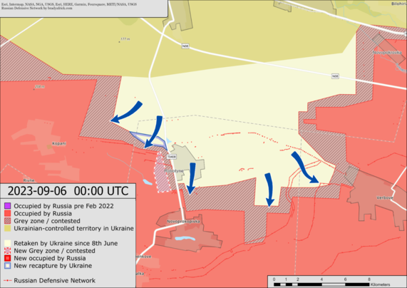
10626 followers · 375 posts · Server mstdn.socialNorthwest of Robotyne 🇺🇦 has made minor gains and is attempting to advance into 🇷🇺 positions west of the settlement.
A map of the approximate situation on the ground in Ukraine as of 00:00 UTC 06/09/23.
#ukraine #russia #ukrainewar #conflict #map #europe #nato #warinukraine #mapping #news #breaking
#Breaking #News #mapping #WARINUKRAINE #NATO #Europe #Map #conflict #UkraineWar #Russia #Ukraine
GregCocks · @GregCocks
674 followers · 562 posts · Server techhub.socialGIS In The Rockies Conference Attendance & Presenting, 2023? - Check!
--
http://gisintherockies.org/ <-- conference web page
--
I - again - appreciate the opportunity...
#GIS #spatial #mapping #gischat #conference #attendance #conference2023 #conferencepresentation #conferencespeaker #GISInTheRockies #Denver #Colorado #GISITR #3dhp #hydrology #water #EDH #spatialdata #opendata #USGS
#gis #spatial #mapping #gischat #conference #attendance #conference2023 #conferencepresentation #conferencespeaker #gisintherockies #denver #colorado #gisitr #3dhp #hydrology #water #edh #spatialdata #opendata #usgs
GregCocks · @GregCocks
674 followers · 561 posts · Server techhub.socialA Drowned Future For Coastal Ecosystems
--
https://www.nature.com/articles/d41586-023-02595-5 <-- shared technical article
--
https://doi.org/10.1038/s41586-023-06448-z <-- shared paper
--
#GIS #spatial #mapping #hydrology #water #hydrospatial #coast #coastal #coastalprotection #coastalecosystems #ecosystems #climatechange #SLR #sealevel #sealevelrise #GMSL #sedimentation #tidal #tidalmarshes #mangroves #foodsecurity #coral #coralreefs #humanimpacts #global #model #modeling #spatialanalysis #remotesensing #flooding #innundation #risk #hazard
#gis #spatial #mapping #hydrology #water #hydrospatial #coast #coastal #coastalprotection #coastalecosystems #ecosystems #climatechange #slr #sealevel #sealevelrise #gmsl #sedimentation #tidal #tidalmarshes #mangroves #FoodSecurity #coral #coralreefs #humanimpacts #global #model #modeling #spatialanalysis #remotesensing #flooding #innundation #risk #hazard
Trufi Association · @trufiassoc
88 followers · 151 posts · Server transportation.socialOpen Source. Open Data. Better Cities. Help us shape urban mobility with one-time or a recurring donation to Trufi Association
#digitaldevelopment #ict4d #ict4dev #informaltransport #innovation #MaaS #mapping #Mobility #morningcommute #multimodal #Multimodality #opendata #opensource #opensourcesoftware #opensteetmap #OpenTripPlanner #publictransit #publictransport #PublicTransportation #software #sustainabletransport #tech #technology #transportation #donate
#digitaldevelopment #ICT4D #ict4dev #informaltransport #innovation #maas #mapping #mobility #morningcommute #multimodal #multimodality #opendata #opensource #opensourcesoftware #opensteetmap #opentripplanner #publictransit #publictransport #publictransportation #software #sustainabletransport #tech #technology #transportation #donate


