
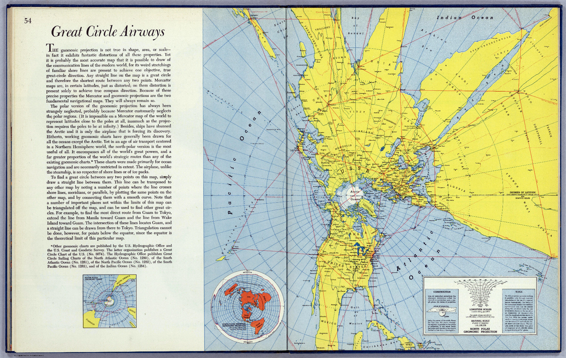
Adamas Nemesis · @adamasnemesis
857 followers · 6235 posts · Server social.adamasnemesis.com
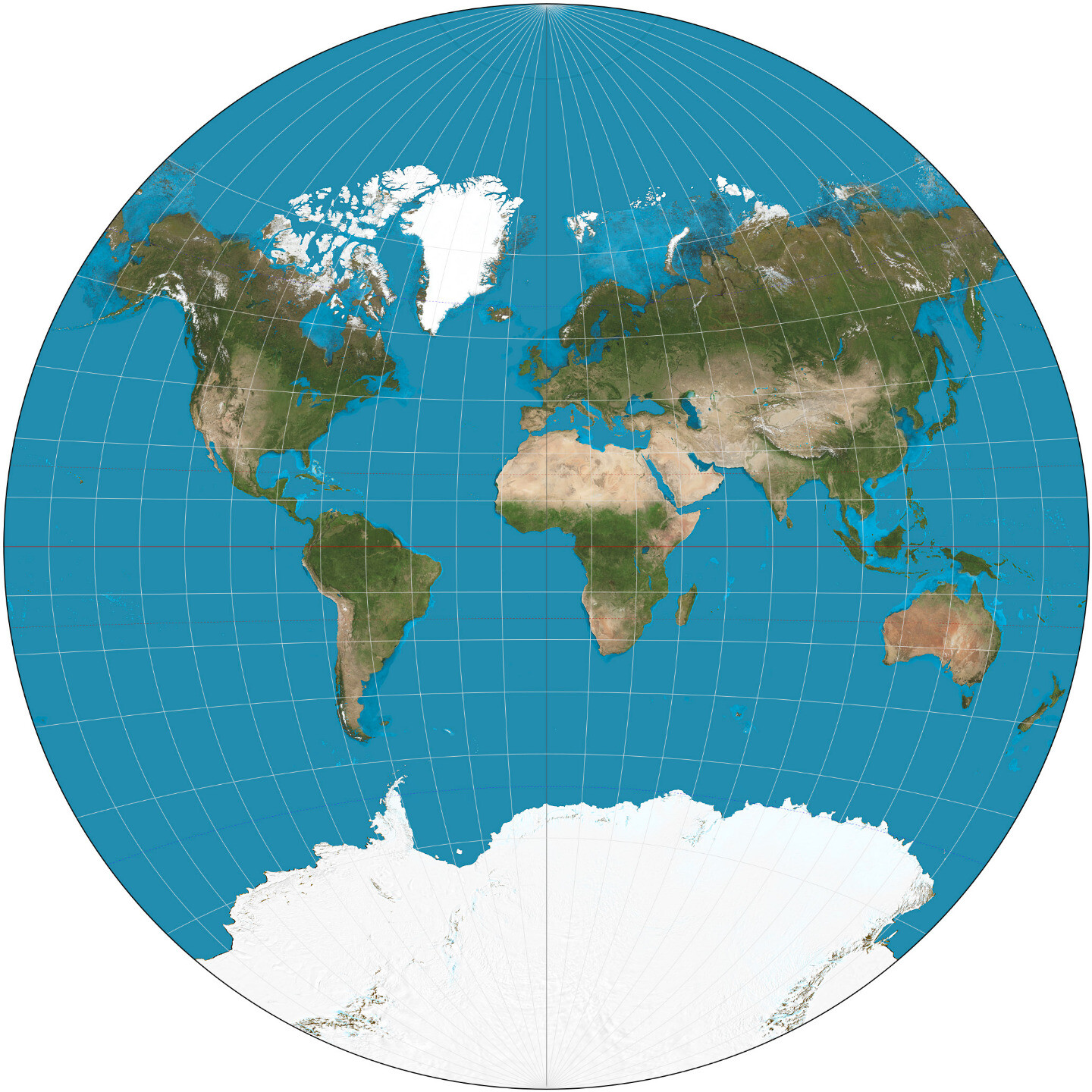
Really crazy how the gnomonic map projection, a cartography uniquely suited to the great-circle navigation that very modern conveyances like airliners use, is the oldest known map projection, discovered by Thales in the sixth century BC.
https://en.wikipedia.org/wiki/Gnomonic_projection
Image is a gnomonic map of much of the northern hemisphere from 1943, with a helpful explanation of how it all works.
#cartography #maps #mapprojections #thoughts #history

Eugene Alvin Villar · @seav
344 followers · 2588 posts · Server en.osm.townAlso, from an aesthetic point of view, I kinda dislike that the continents in the Lee–Concialdi projection are smushed at the bottom of the map leaving the top third with the vast empty Pacific. Feels just a bit imbalanced to me. 🤷
4/4 🧵
Eugene Alvin Villar · @seav
344 followers · 2587 posts · Server en.osm.townFor me, the Lee–Concialdi eliminates two major problems I have with the Cahill–Concialdi: (1) Antarctica is halved and way overinflated, and (2) the Bering Strait is split (not a problem with the Dymaxion).
On the other hand it does introduce new problems: (1) because it is tetrahedral instead of octahedral like the Cahill, the area inflations are much larger, and (2) the math is much harder to figure out unlike the Cahill whose octants I fully understand the maths of.
3/4 🧵
Eugene Alvin Villar · @seav
344 followers · 2586 posts · Server en.osm.townI recently learned about the Lee–Concialdi projection from Tobias Jung’s blog post: https://blog.map-projections.net/second-serving-two-more-lee-variants
It’s basically a variation of the conformal tetrahedral projection that L. P. Lee developed in 1965*, but rearranged in such a way to avoid interrupting or grossly inflating major landmasses.
* https://en.wikipedia.org/wiki/Lee_conformal_world_in_a_tetrahedron
2/3 🧵
Eugene Alvin Villar · @seav
344 followers · 2585 posts · Server en.osm.town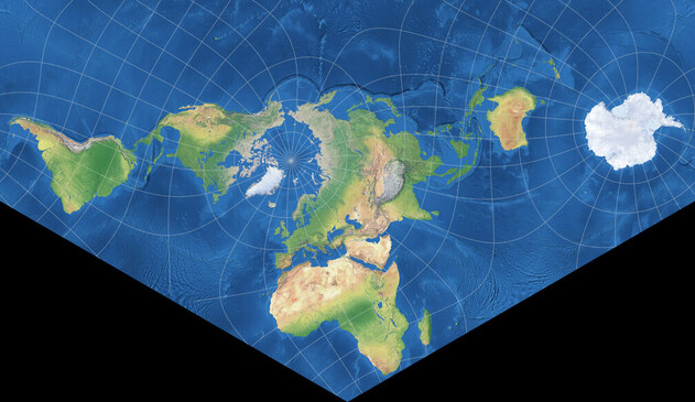
For today’s #MappyMondays, I’ll talk about what is probably my now second-most favorite map projection: the “Lee conformal tetrahedral projection – Concialdi rearrangement” aka the Lee–Concialdi projection. 🗺️
This projection was announced in 2020 by Luca Concialdi, the same person behind the Cahill—Concialdi bat map projection that is my current favorite. With the Lee variant projection, it shows that Luca’s preferences for good projections really aligns with my own!
1/3 🧵
Adamas Nemesis · @adamasnemesis
770 followers · 5620 posts · Server social.adamasnemesis.com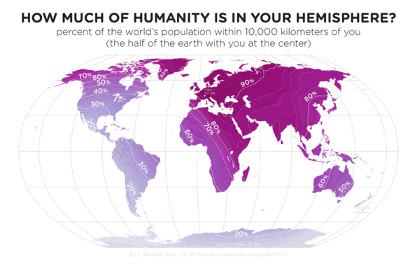
Get a load of this map of how much of humanity is in your personal hemisphere. Kinda impressive how remote my abode, the United States, is compared to most other countries. Guess us Americans just get used to the idea of flying nearly-antipodal distances to reach most people. Hmm.
#maps #mapprojections #demography #geography #population #thoughts #self #travel #demographics
#maps #mapprojections #demography #geography #population #thoughts #self #travel #demographics
Adamas Nemesis · @adamasnemesis
770 followers · 5619 posts · Server social.adamasnemesis.com
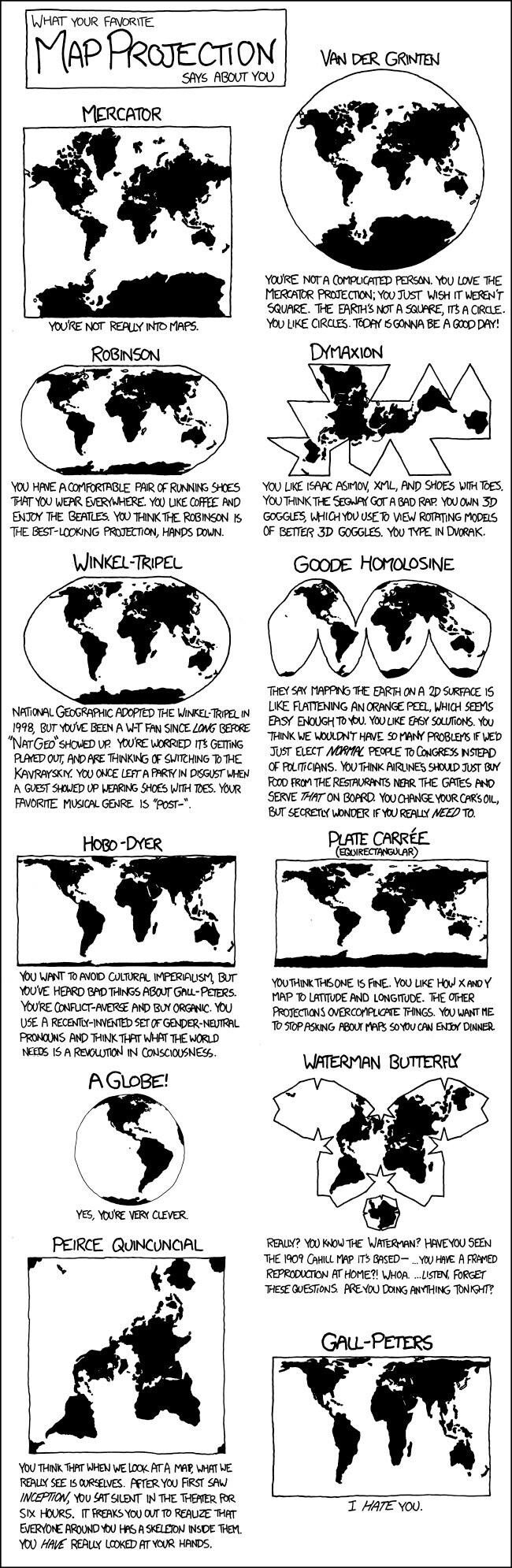
XKCD's take on what your favorite map projection says about you. As someone who likes the Dymaxion projection, it's just too accurate for comfort...
#maps #cartography #thoughts #mapprojections
Adamas Nemesis · @adamasnemesis
771 followers · 5607 posts · Server social.adamasnemesis.com
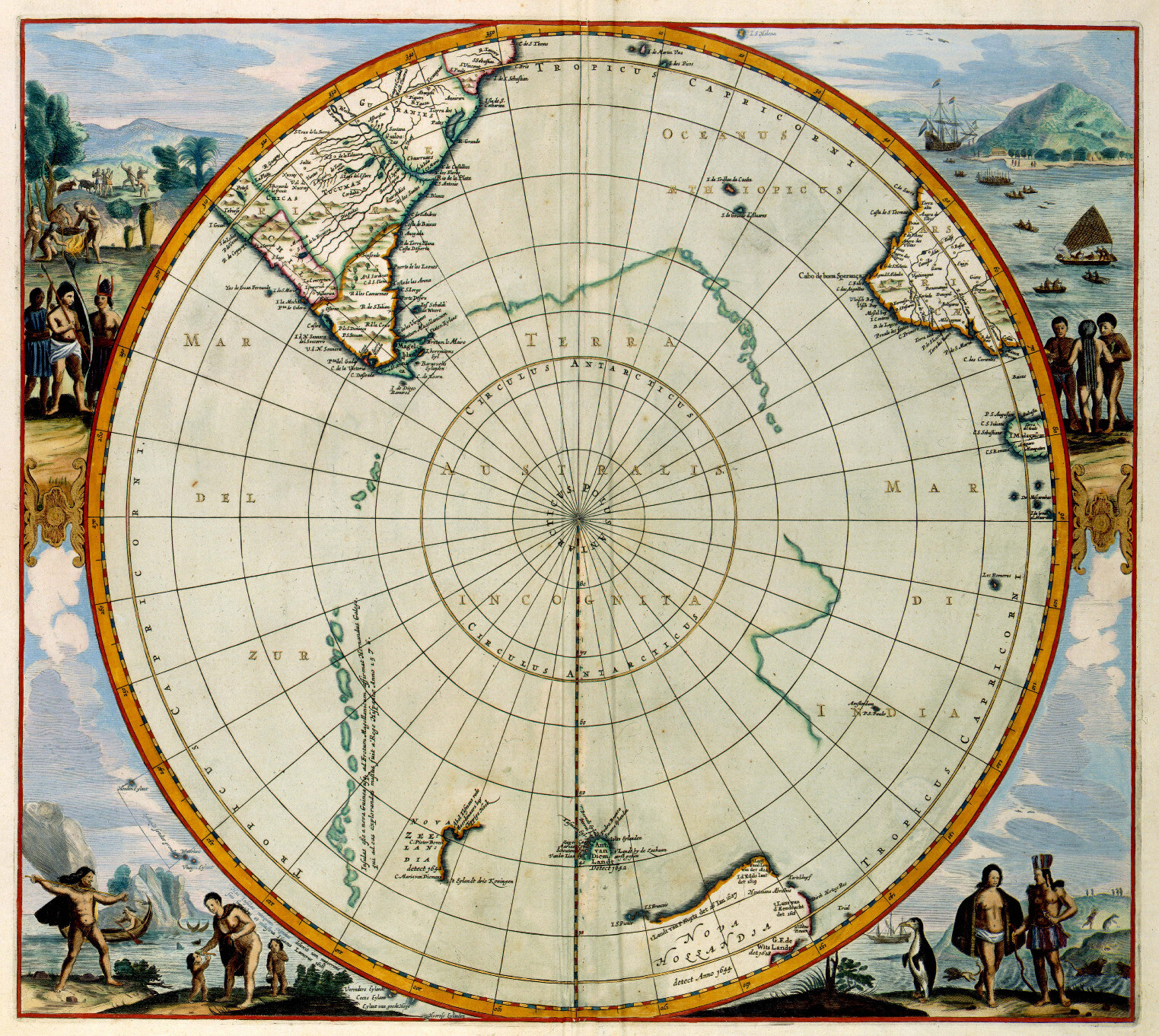
My thoughts wander cartographically, from gnomonic projections to prime meridians to the land and water hemispheres.
Read more at my #blog: https://www.adamasnemesis.com/2023/04/22/more-fun-with-cartography/
This post's featured image is a 1657 map by Jan Janssonius.
#cartography #geography #geometry #primemeridian #maps #mapprojections #gnomonicprojection #greatcircles #greatcirclenavigation #greatcircleroutes #landhemisphere #waterhemisphere #demography
#blog #cartography #geography #geometry #primemeridian #maps #mapprojections #gnomonicprojection #greatcircles #greatcirclenavigation #greatcircleroutes #landhemisphere #waterhemisphere #demography
Adamas Nemesis · @adamasnemesis
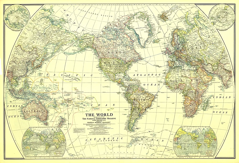
770 followers · 5599 posts · Server social.adamasnemesis.com
Maybe because it has a certain antique charm to it, like some steampunk artifact that wouldn't look out of place on a circular locket or as the backdrop of a pocket watch. Helps that it was invented in 1898 and was used for a long time by the National Geographic Society. 🙂
#maps #mapprojections #cartography #thoughts #steampunk #history
#maps #mapprojections #cartography #thoughts #steampunk #history
Adamas Nemesis · @adamasnemesis
770 followers · 5598 posts · Server social.adamasnemesis.com
Don't know why, but the more I see the Van der Grinten projection the more it grows on me. Sure, it's only a modest improvement on the Mercator, greatly inflating landmasses near the poles, but you can see the poles really well, and the perfectly circular shape of the map is 😍.
#maps #mapprojections #cartography #thoughts
Adamas Nemesis · @adamasnemesis
770 followers · 5511 posts · Server social.adamasnemesis.com
Mercator? Robinson? Winkel tripel? Think bigger! There's a whole universe of map projections out there: Kavrayskiy, Dymaxion, and more.
Read a few thoughts at my #blog: https://www.adamasnemesis.com/2023/04/06/of-map-projections-obscure/
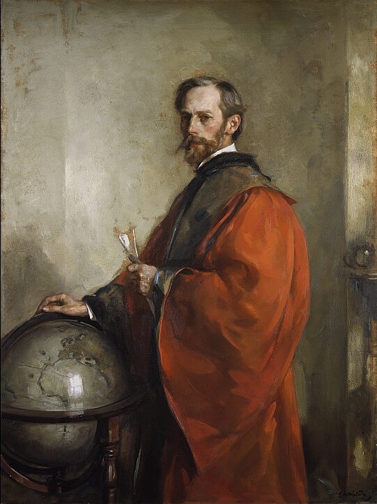
This post's featured image is Edward Arthur Walton's "John George Bartholomew" (1911).
#maps #mapprojections #cartography #geography #worldbuilding
#blog #maps #mapprojections #cartography #geography #worldbuilding