Maptime Amsterdam · @MaptimeAMS
7 followers · 3 posts · Server mastodon.nlFeeling like you missed out? Stay tuned for the next #maptime Amsterdam event!
Maptime Amsterdam · @MaptimeAMS
0 followers · 1 posts · Server mastodon.nlOn Friday September 8, #tmsystems and #tomtom welcome you for a #maptime meet-up at the TomTom Amsterdam office. Join Shravan Shah, Salim Baidoun and @marjanvdk for drinks, snacks and inspiring #mapmaking talks.
Learn how to map a city with street-level imagery from Stéphane De Greef of @osm_be, and find out how TomTom contributes to and collaborates with #openstreetmap from TomTom community engagers Salim and Marjan.
Let's make time for #maps! Sign up by September 4
https://www.meetup.com/maptime-ams/events/295672495/
#maps #openstreetmap #mapmaking #maptime #tomtom #tmsystems
Maryanne Wachter · @mclare
300 followers · 709 posts · Server recurse.socialMe this weekend: ok, yay I finished up a big side project, time to focus on DS+A and work through that Rust+Webassembly…*GARBAGE BRAIN: What about maps?? MOAR MAPS!! You just got that NYC DOB complaint data set and it is relevant!! MOAR MAPS!!
… garbage brain won today 🤷🏼♀️
#datavisualization #mapdata #maptime #dataviz
Darrell Carvalho · @Darrell_Carvalho
187 followers · 12 posts · Server mapstodon.spaceI am excited to take part in my first #MapTime #Mapathon with #MapTimeLA. So far I am enjoying it, I love that somewhat local options for meeting other #spatial folks and contributing to #HOSM and #OpenStreetMap
#maptime #mapathon #maptimela #spatial #hosm #OpenStreetMap
Maryanne Wachter · @mclare
298 followers · 699 posts · Server recurse.socialBeen fighting with overconstraining the camera movement but I think it’s *nearly* there #dataviz #maptime #protomaps @maplibre
Technologiestiftung Berlin · @technologiestiftungberlin
24 followers · 83 posts · Server mastodontech.deRT @citylabberlin
Heute Abend zur #Maptime der #ODISBerlin dürfen wir Thomas @tursics (@govdata_de) begrüßen!👋 „Nur wenn wir offene Daten aktiv erfragen und richtig darstellen, erreichen wir Impact“ sagt der #OpenData & #CivicTech-Enthusiast.
#maptime #odisberlin #opendata #civictech
CityLAB Berlin · @citylabberlin
29 followers · 88 posts · Server mastodontech.deTim Hönig (@FHPotsdam) zeigt bildlich „Die Geschichte des Tagebaus“ — Die #Visualisierung zeigt Infos zu Protesten und Ortsdaten der Orte, die für Kohleabbau weichen mussten: http://verschwundene-ortschaften.honigmitoe.de | #Maptime #ODISBerlin
#visualisierung #maptime #odisberlin
CityLAB Berlin · @citylabberlin
29 followers · 87 posts · Server mastodontech.deHeute Abend zur #Maptime der #ODISBerlin dürfen wir Thomas @tursics (@govdata_de) begrüßen!👋 „Nur wenn wir offene Daten aktiv erfragen und richtig darstellen, erreichen wir Impact“ sagt der #OpenData & #CivicTech-Enthusiast.
#maptime #odisberlin #opendata #civictech
CityLAB Berlin · @citylabberlin
29 followers · 85 posts · Server mastodontech.deHappy #OpenDataDay2023! Sehen wir uns morgen zur #Maptime-Session bei uns im CityLAB? Hier geht's zur Anmeldung: https://citylab-berlin.org/de/events/maptime-berlin/!
CityLAB Berlin · @citylabberlin
27 followers · 77 posts · Server mastodontech.deSpotted! 📍Seid dabei und meldet euch an zur #Maptime-Session anlässlich des diesjährigen #OpenDataDay 👉 https://citylab-berlin.org/de/events/maptime-berlin/ #ODD2023
---
RT @govdata_de
Der #OpenDataDay2023 #odd23 ist da. Geht hin:
💡 morgen, Datenspaziergang in Wien
💡 Sa ab 9:00 in München
💡 Sa ab 10:00 in Köln
💡 Sa ab 10:00 in Bielefeld (online)
💡 Sa ab 15:00 in Karlsruhe
💡 6.3. ab 18:00 in Berlin
💡 8.3. ab 19:00 in Leipzig
💡 18. - 19.…
https://twitter.com/govdata_de/status/1631228489281019905
#maptime #opendataday #odd2023 #opendataday2023 #odd23
CityLAB Berlin · @citylabberlin
27 followers · 72 posts · Server mastodontech.deDu liebst Karten & offene Daten?🤓🗺Dann halt dich fest: Zur Feier des #OpenDataDay2023 laden die #OpenData Informationsstelle & die Crew hinter dem beliebten #Maptime-Meetup am 06.03. zu einer gemeinsamen Session zu uns ins CityLAB ein! Jetzt anmelden: https://citylab-berlin.org/de/events/maptime-berlin/
#opendataday2023 #opendata #maptime
spatialThinkLab · @spatialThinkLab
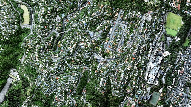
132 followers · 23 posts · Server mastodon.nzThis stunning image made with a 25cm DSM (digital surface model) from Wellington City 2019-2020 LiDAR and blended with aerial imagery was produced by Emory Beck for our #mapTimeWgtn events this year. Looking forward to reconnecting with spatial folks in person in Feb.
#maptimewgtn #maptime #cartography #geospatial
Maryanne Wachter · @mclare
273 followers · 625 posts · Server recurse.socialIt turns out the happy path for free mappy goodness is geofabrik -> planetiler -> mbtiles
I used the docker image of planetiler (new Java won't build on my Mac) and downloaded the required files separately based on the container command
https://download.geofabrik.de/
https://github.com/onthegomap/planetiler
I used pmtiles to convert from .mbtiles to .pmtiles
https://github.com/protomaps/go-pmtiles/releases
Then made the video from a screen cap with viewing tiles in protomap's viewer
https://protomaps.github.io/PMTiles/
#maptime #maps #dataviz
MapAm💜re · @MapAmore
523 followers · 1021 posts · Server en.osm.townRT @maptimemelb@twitter.activitypub.actor
Last chance to register for tomorrow's free mapathon! Come along and help us make Melbourne more accessible for people with a disability. No experience required (and there will be free pizza!) #melbourne #maptime https://www.meetup.com/en-AU/Maptime-Melbourne/events/268418625/
MapAm💜re · @MapAmore
523 followers · 1021 posts · Server en.osm.townRT @maptimemelb@twitter.activitypub.actor
Our first event for 2020 is now up! Join us on 13 February to add data to @openstreetmap@twitter.com and help people with a disability move around Melbourne. All welcome, no experience required! #maptime https://www.meetup.com/en-AU/Maptime-Melbourne/events/268418625/
Eric 🌿🏳️🌈🚅 🌍 🚴 · @eric
171 followers · 483 posts · Server mastodon.ericbeckers.nlEric 🌿🏳️🌈🚅 🌍 🚴 · @eric
171 followers · 483 posts · Server mastodon.ericbeckers.nlNext weekend #maptime in Amsterdam.
https://waag.org/en/event/maptime-special-deep-mapping
The more I read about it, especially Arita Baaijens project https://www.paradijsindepolder.nl/ the more enthousiastic I get. Happy to have registered in time because there's a waiting list now.


