IT News · @itnewsbot
3552 followers · 268218 posts · Server schleuss.onlineWorld’s heaviest commercial communications satellite will launch tonight - Enlarge / SpaceX's Falcon Heavy rocket stands on Launch Complex 39A at ... - https://arstechnica.com/?p=1956756 #commercialspace #falconheavy #broadband #hughesnet #echostar #internet #jupiter3 #spacex #space #maxar
#maxar #space #spacex #jupiter3 #internet #echostar #hughesnet #broadband #falconheavy #commercialspace
Tech news from Canada · @TechNews
884 followers · 23371 posts · Server mastodon.roitsystems.caArs Technica: World’s heaviest commercial communications satellite will launch tonight https://arstechnica.com/?p=1956756 #Tech #arstechnica #IT #Technology #Commercialspace #falconheavy #broadband #hughesnet #EchoStar #Internet #Jupiter3 #spacex #Space #Maxar
#Tech #arstechnica #it #technology #commercialspace #falconheavy #broadband #hughesnet #echostar #internet #jupiter3 #spacex #space #maxar
OpenStreetMap · @openstreetmap
6010 followers · 274 posts · Server en.osm.town“We are aware of the Maxar imagery unavailability issue and have been in regular contact with them about key rotation and other security mitigation efforts. We have not heard much, but are trying to resolve.”
@grischard (OSMF Chair)
#OpenStreetMap #OSM #Maxar #OSMF
#OpenStreetMap #OSM #maxar #osmf
OpenStreetMap · @openstreetmap
6010 followers · 273 posts · Server en.osm.townAdditional Information about the Maxar Imagery issue can be found in the OSM community forum
Charles Danforth 🐘🏕🏃🏻♂️ · @c_dan4th
400 followers · 2185 posts · Server mstdn.social
Anita Graser 🇪🇺🇺🇦 · @underdarkGIS
2208 followers · 1439 posts · Server fosstodon.orgLatest #QGIS plugins releases: https://blog.qgis.org/2023/06/08/plugin-update-may-2023/
My personal - completely subjective - highlights in May:
1️⃣ MGP Connect by #Maxar @maxar to stream their #imagery
2️⃣ DiscordRPC to display your QGIS activity in #Discord
3️⃣ #HOT Templates and Symbology Manager by @kartozageo #humanitarian #openstreetmap #osm
4️⃣ Adjust Style to adjust the symbology of all layers (or selected layers) consistently
5️⃣ qaequilibrae new release of the #AequilibraE #Transportation modeling toolbox
#qgis #maxar #imagery #discord #hot #humanitarian #openstreetmap #osm #aequilibrae #transportation #gischat
Norobiik @Norobiik@noc.social · @Norobiik
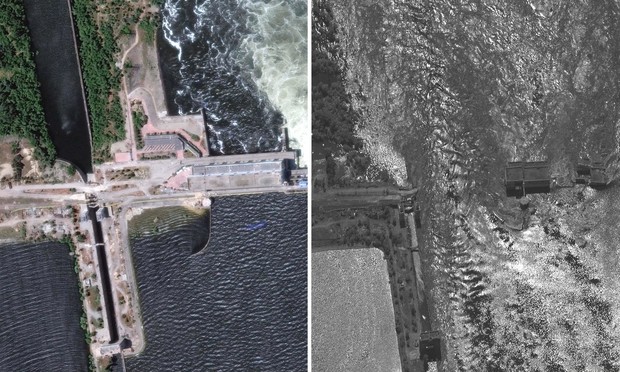
325 followers · 5212 posts · Server noc.social"#Maxar said that their images covered more than 2,500 square km between #NovaKakhovka and the #DniprovskaGulf southwest of #Kherson city on the #BlackSea, giving some idea of the scale of the crisis."
#KakhovkaDam flooding before and after: satellite images reveal extent of disaster in #Ukraine | #UkraineWar| The Guardian
https://www.theguardian.com/world/2023/jun/07/kakhovka-dam-flooding-ukraine-before-and-after-satellite-images-reservoir-kherson-oblast
#UkraineWar #ukraine #kakhovkadam #Blacksea #Kherson #dniprovskagulf #NovaKakhovka #maxar
Poetry News · @haikubot
743 followers · 7660 posts · Server mastodon.cloudSatellites from high view
Capture the stories untold
Maxar now tracking
#maxar #satellite #tracking #cnnbusiness #haiku #poetry
AmplifyUkraine · @ua
320 followers · 53929 posts · Server osintua.euTRANSLATION :
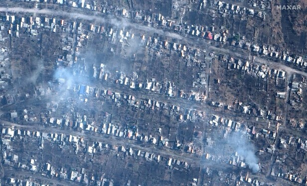
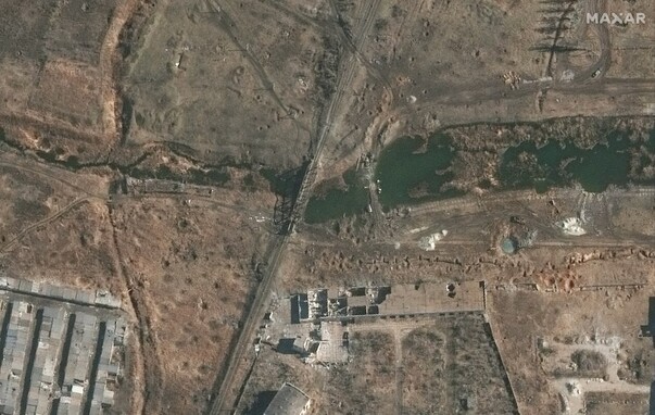
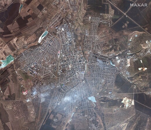
🛰️ Maxar Technologies released satellite images of Bakhmut
The first images were taken on May 8, 2022, and the rest on May 15, 2023.
#Maxar #Bakhmut
@milinua
ORIGINAL :
🛰️ Maxar Technologies оприлюднив супутникові знімки Бахмута
Перші світлини зроблені 8 травня 2022 року, інші — 15 травня 2023 року.
#Maxar #Бахмут
@milinua
SOURCE :
https://t.me/milinua/22770
М
Media : https://ukraine.osintukraine.com/media/2023-05-18/447781.jpg
Archive : https://ukraine.osintukraine.com/2023-05_32.html#447781
John Freeman · @Scifiguy
124 followers · 222 posts · Server home.social#space #resources #satellite #Maxar
Maxar eyes summer launch of WorldView Legion imaging satellites
https://spacenews.com/maxar-eyes-summer-launch-of-worldview-legion-imaging-satellites/ via @SpaceNews_Inc
#Space #resources #satellite #maxar
Daniel Fischer · @cosmos4u
1348 followers · 2264 posts · Server scicomm.xyzThe SpaceX #BocaChica launch facilities in Texas with a view of the #Starship and Super Heavy rocket on the launch pad - as seen on 17 April by a #Maxar satellite: https://scicomm.xyz/@CosmicPenguin@spacey.space/110217049665243512
John Freeman · @Scifiguy
116 followers · 185 posts · Server home.social#space #spaceresources #satellite #maxar #Tornado
My deepest sympathies to the families of those who were killed.
Devastation from deadly Mississippi tornado spotted from space (satellite photos)
https://www.space.com/mississippi-tornado-satellite-imagery-town-devastation
#Space #spaceresources #satellite #maxar #tornado
BenB · @benb
1876 followers · 7243 posts · Server osintua.euCONTEXT : #Bakhmut
TRANSLATION : Fresh satellite images of Bakhmut from #Maxar, dated March 6, 2023. #Ukraine
SOURCE : 🇷🇺 https://t.me/boris_rozhin/80139
BenB · @benb
1876 followers · 7242 posts · Server osintua.euCONTEXT : #Bakhmut
TRANSLATION : Fresh satellite images of Bakhmut from #Maxar, dated March 6, 2023. #Ukraine
SOURCE : 🇷🇺 https://t.me/boris_rozhin/80139
BenB · @benb
1876 followers · 7239 posts · Server osintua.euCONTEXT : #Bakhmut
TRANSLATION : Fresh satellite images of Bakhmut from #Maxar, dated March 6, 2023.
SOURCE : https://t.me/boris_rozhin/80139
Qiusheng Wu · @giswqs
178 followers · 29 posts · Server fosstodon.orgVisualize #Maxar Open Data for the Turkey-Syria #earthquake using #leafmap. Search for images and return footprints as a GeoDataFrame with one line of code. Compare pre-event and post-event images side by side 👇
Notebook: https://leafmap.org/notebooks/69_turkey_earthquake/
Video: https://youtu.be/wevzJfOf5GQ
#maxar #earthquake #leafmap #geospaital #geopython
Grabancijaš · @Grabancijas
2 followers · 128 posts · Server masto.ai#UnitedStates declared that #Russia committed #crimesagainsthumanity in #Ukraine.
Accusation that is graver than war crimes in eyes of international #law.
#Harris evoked #Bucha #massacre, but there are issues with this particular event and Russian president #Putin claims that it was staged.
One of the oddities is apparent state of the bodies whom have had lied intact on the streets for many a days as captured by #Maxar.
Time will tell.
#unitedstates #russia #crimesagainsthumanity #ukraine #law #harris #bucha #massacre #putin #maxar
AkaSci · @AkaSci
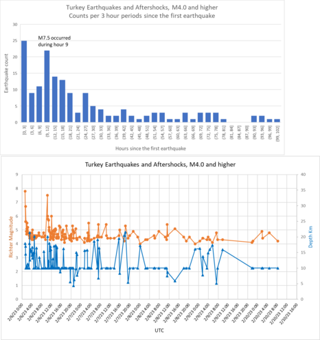
932 followers · 736 posts · Server fosstodon.orgEarthquake and aftershock activity was mercifully low yesterday but we had a few aftershocks in the region overnight.
#earthquake #turkey #maxar
3/n
AkaSci · @AkaSci
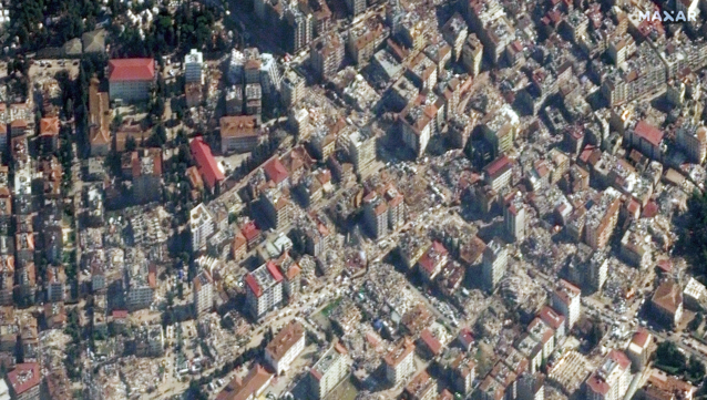
932 followers · 735 posts · Server fosstodon.orgMaxar Technologies has made satellite imagery of the region affected by the earthquake in Turkey open to the public and to response teams.
Some of the images of collapsed high-rises are simply unimaginable.
https://blog.maxar.com/for-a-better-world/2023/open-data-response-to-the-earthquakes-in-turkey-and-syria
Image source: https://twitter.com/Maxar/status/1623464524090314753
Credit: Maxar
#earthquake #turkey #maxar
2/n
AkaSci · @AkaSci
932 followers · 735 posts · Server fosstodon.orgMaxar Technologies has made satellite imagery of the region affected by the earthquake in Turkey available to the public.
Some of the images of collapsed high-rises are simply unimaginable.
https://blog.maxar.com/for-a-better-world/2023/open-data-response-to-the-earthquakes-in-turkey-and-syria
Image source: https://twitter.com/Maxar/status/1623464524090314753
Credit: Maxar
#earthquake #turkey #maxar
2/n

