karen · @geekaren
948 followers · 615 posts · Server mstdn.socialMatt Beckwith: A Flood Watch is in effect for the eastern part of our viewing area (mid-Missouri) along and south of I-70 and east of Highway 63. This watch is in effect until 10AM Thursday. #MoWx #MidMoWx
NWS St Louis: lash flooding expected again tonight. Has the potential to be significant if heaviest rain falls in metro areas or locations that recently received excess rain. #mowx #ilwx #stlwx
#flashflood #stlwx #ilwx #midmowx #mowx
Kat · @katduncan
88 followers · 638 posts · Server nerdculture.deYESSSSSS
---
RT @JessicaABC17
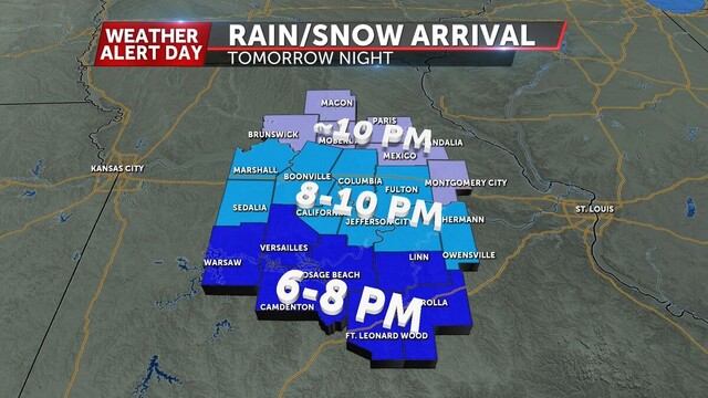
Here's an update on our winter storm forecast for Tuesday PM - Wednesday. Amounts will largely fall in the 2-6" range with a few isolated higher amounts along the I-44 corridor. I'll have the newest Futuretrack at 5:00 on @ABC17News https://abc17news.com/weather/2023/01/22/weather-alert-day-accumulating-snow-possible-tuesday-night-into-wednesday/ #midmowx
https://twitter.com/JessicaABC17/status/1617653844124499971
Mark Heckler · @mkheck
575 followers · 159 posts · Server mastodon.cloudRT @NWSStLouis
Anyone notice a draft in here? 🥶🥶
It was brutally cold last night (not like today is much better). Here are last night's wind chills, with some comparison to a similar event from 2014. In St. Louis, this was the 9th coldest wind chill ever measured! #MOwx #ILwx #STLwx #MidMOwx
Kat · @katduncan
80 followers · 379 posts · Server nerdculture.deRT @NWSStLouis
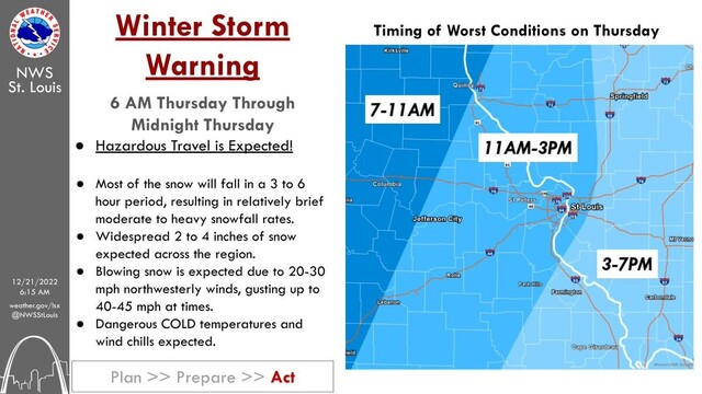
An Arctic cold front🥶 will blast thru the area on THU bringing plummeting temps, dangerous wind chills, & accumulating snowfall❄️. 2-4" of snowfall is expected with most of that snow falling in 3-6 hours, resulting in hazardous travel conditions. #stlwx #mowx #ilwx #midmowx


