
AI6YR · @ai6yr
4609 followers · 31052 posts · Server m.ai6yr.org
AI6YR · @ai6yr
4262 followers · 26527 posts · Server m.ai6yr.org
AI6YR · @ai6yr
4262 followers · 26527 posts · Server m.ai6yr.org
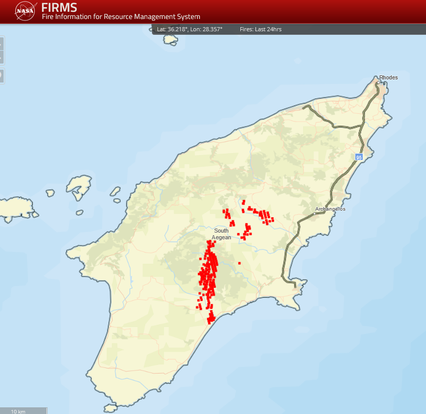
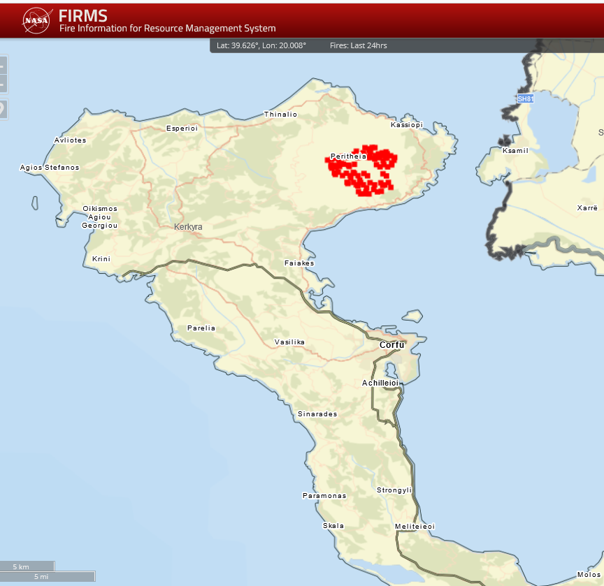
#wildfire signature on #Corfu #Greece -- looks like the wildfire is in #Peritheia based on satellite signature 7/24/2023 #MODIS
#Wildfire #corfu #greece #peritheia #modis
Dustˆ2 · @dustsquared
82 followers · 370 posts · Server mstdn.science
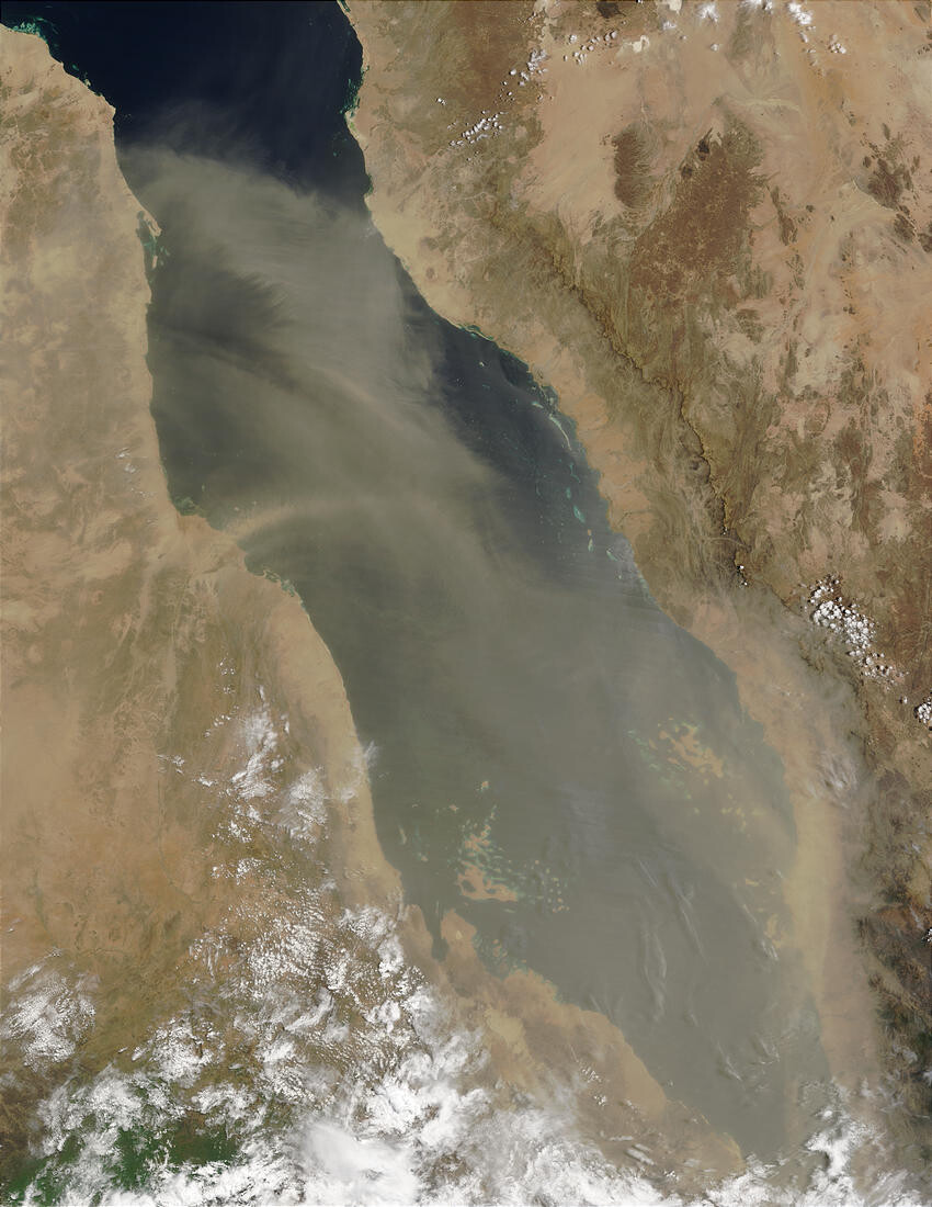
Image of a #dust storm captured by #MODIS in 2002.
The African countries of #Sudan (top left), #Ethiopia (bottom left), with #Eritrea nestled between them along the western coast of the Red Sea. On image right are Saudi Arabia (top) and #Yemen (bottom) on the Arabian Peninsula. Overlooking the Red Sea, a long escarpment runs along the western edge of the Arabian Peninsula, and in this image appears to be blocking the full eastward expansion of the dust storm.
https://visibleearth.nasa.gov/images/60664/dust-storm-over-the-red-sea
#dust #modis #sudan #ethiopia #eritrea #yemen
Warren Currie 🦠🦐 · @DrPlanktonguy
311 followers · 601 posts · Server ecoevo.social
The story on "greening of the oceans" has been covered recently, but kudos to the Guardian on this article. The collaborative study (link in article) led by the National Oceanography Centre, Southhampton uses #MODIS satellite data from 56% of the ocean surface and a #biogeochemistry model to measure increased green colour (chlorophyll-a in #phytoplankton), esp in the temperate ocean, over the last 20 years (which is short!). #ClimateChange
https://www.theguardian.com/environment/2023/jul/12/worlds-oceans-changing-colour-due-to-climate-breakdown-study-suggests
#plankton #factoid #modis #biogeochemistry #phytoplankton #climatechange

mohansus · @mohansus
201 followers · 149 posts · Server newsie.social
The "real test" of #modis visit to the #unitedstates is the #outcome of these "turf wars" between #local and #global #firms.
This is a #catch22 situation. #india needs #foreigninvestment, but not at the #cost of #homegrown #oligarchs, who are also on the "right" side of the ruling dispensation.
How the #modigovernment untangles this "gordian knot" remains to be seen. Much like the #adani #hindenburg #saga, which our #media framed in #nationalistic terms.
#modis #UnitedStates #outcome #local #global #firms #catch22 #india #foreigninvestment #cost #Homegrown #oligarchs #modigovernment #adani #hindenburg #saga #media #nationalistic

Paul SomeoneElse · @pkw
140 followers · 166 posts · Server mastodon.sdf.orgI'm pretty sure I already posted this, but with the wildfires in Canada there's a connection.
Lots of the wildfire detection images you see are from the Terra and Aqua satellites.
Anyways here's a movie I made of the moon from Terra (or Aqua I forget) when doing a "rotate maneuver" where it would flip to look out in space for black body type of calibrations.
My manager told me the moon would sneak into frame. If the full sensor was shown this would be very small.

GregCocks · @GregCocks
278 followers · 359 posts · Server techhub.social
Plankton Generate a Cloudy Shield over the Antarctic
--
https://www.scientificamerican.com/article/plankton-generate-a-cloudy-shield-over-the-antarctic/ <-- shared technical article
--
https://doi.org/10.5194/acp-23-1677-2023 <-- shared paper
--
#GIS #spatial #mapping #watervapour #watervapor #nucleus #nucleation #cloud #whitening #climatemodels #cloudformation #clouds #weather #albedo #plankton #phytoplankton #remotesensing #satellite #MODIS #model #modeling #Antarctic #sunlight #climate #reflection #climatechange #warming #radiation #dimethylsulfide #aerosl #particles #marineboundarylayer #MBL
@noaa
#gis #spatial #mapping #watervapour #watervapor #nucleus #nucleation #cloud #whitening #climatemodels #cloudformation #clouds #weather #albedo #plankton #phytoplankton #remotesensing #satellite #modis #model #modeling #antarctic #sunlight #climate #reflection #climatechange #warming #radiation #dimethylsulfide #aerosl #particles #marineboundarylayer #mbl
Paul SomeoneElse · @pkw
141 followers · 119 posts · Server mastodon.sdf.org#NASA #TERRA #AQUA #MODIS #MCST
I worked for SSAI in greenbelt MD, as a NASA subcontractor.
(I had GSFC pass and library card)
Our team calibrated the Terra and Aqua EARTH OBSERVING satellites.
One of them did a "rotation maneuver" to look into space to help calibrate it.
My manager explained to me that the moon would pass by the EARTH OBSERVING camera, and helped me track down the time.
I made this movie.
Again, this an EARTH OBSERVING satellite. The moon is tiny in the full frames.
#nasa #terra #aqua #modis #mcst
GregCocks · @GregCocks
202 followers · 259 posts · Server techhub.social
El Niño Watch Has Been Issued By NOAA, With Large-Scale Atmospheric And Oceanic Changes Now Being Detected As We Head For The Next ENSO Phase
--
https://www.severe-weather.eu/long-range-2/el-nino-watch-noaa-forecast-seasonal-weather-impact-summer-winter-united-states-canada-europe-fa/ <-- shared article
==
El Niño Watch Issued By NOAA's Climate Prediction Center
--
https://www.cbsnews.com/news/el-nino-watch-issued-noaa-climate-prediction-weather/ <-- shared media article
==
El Niño Disrupts the Marine Food Web
--
https://earthobservatory.nasa.gov/images/86895/el-nino-disrupts-the-marine-food-web <-- shared technical article
--
#GIS #spatial #mapping #model #modeling #global #marine #extremeweather #elnino #elniño #ecosystems #remotesensing #climate #climateprediction #weather #climaterisk ##ElNinoWatch #ecosystem #currents #cooling #warming #water #thermocline #nutrients #foodsupply #foodweb #MODIS #drought #hurricanes #SouthernOscillation
NOAA: National Oceanic & Atmospheric Administration | NOAA National Ocean Service | NOAA Fisheries##
#gis #spatial #mapping #model #modeling #global #marine #extremeweather #ElNino #ecosystems #remotesensing #climate #climateprediction #weather #ClimateRisk #elninowatch #ecosystem #currents #cooling #warming #water #thermocline #nutrients #foodsupply #foodweb #modis #drought #hurricanes #southernoscillation
Sidney Schaberle Goveia · @geosapere
58 followers · 47 posts · Server mapstodon.space
Microsoft Planetary Computer
▪︎Acesso à imagens de satélite 🛰 abertas: #Landsat, #Sentinel, #MODIS, #ASTER, #ALOS (#STAC API);
▪︎Processamento distribuído ("nuvem" ☁️) usando aplicações: #Python, R #rstats, #PyTorch, #Tensorflow e #QGIS.
https://planetarycomputer.microsoft.com
#landsat #Sentinel #modis #aster #ALOS #STAC #python #RStats #pytorch #tensorflow #qgis

Chuixiang (Tree) Yi · @TreeYi
9 followers · 3344 posts · Server mastodon.world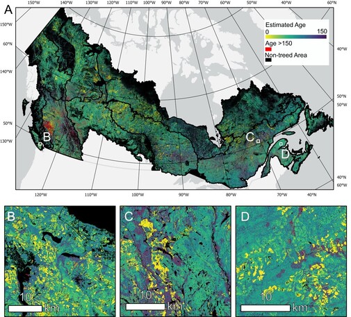
RT @James_Maltman_1
Excited to announce the publication of my first paper! Using #Landsat derived #NTEMS products and #MODIS data we estimated forest age at 30-m spatial resolution across Canada’s forested ecosystems! https://www.sciencedirect.com/science/article/pii/S0034425723000809
Ladies of Landsat · @LadiesOfLandsat
663 followers · 78 posts · Server mapstodon.space
.@IleanaCallejas et al. (2021) analyze imagery from #MODIS #Aqua from #GoogleEarthEngine with marine traffic & precipitation data to establish an improvement in water quality in Belize Coastal Lagoon during the #COVID19 anthropause. #LoLManuscriptMonday https://bit.ly/Callejas_2021
#modis #aqua #GoogleEarthEngine #COVID19 #LoLManuscriptMonday

Ingmar Nitze · @i_nitze
145 followers · 206 posts · Server mapstodon.space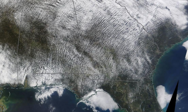
Cloud streets over the southeastern US
2023-02-22
#MODIS #Terra
#satellite #geo #remotesensing
#modis #terra #satellite #geo #remotesensing

mohansus · @mohansus
190 followers · 98 posts · Server newsie.socialCan #xi's loss become #modis gain? Looks like "we" have gotten off to a good start by "persuading" #apple to make #iphones in #india, as part of its #chinaplus #supplychain #diversification #strategy.
Of course, #morganstanley estimates the "jump" in #manufacturing #exports to be from the present 480 Billion USD to $1 #trillion by 2028. So, there is hope of the long awaited #industrial #renaissance.
#Xi #modis #apple #iphones #india #chinaplus #supplychain #diversification #strategy #morganstanley #manufacturing #exports #trillion #industrial #renaissance
Ragnar Heiðar Þrastarson · @RagnarHeidar
160 followers · 41 posts · Server mastodon.social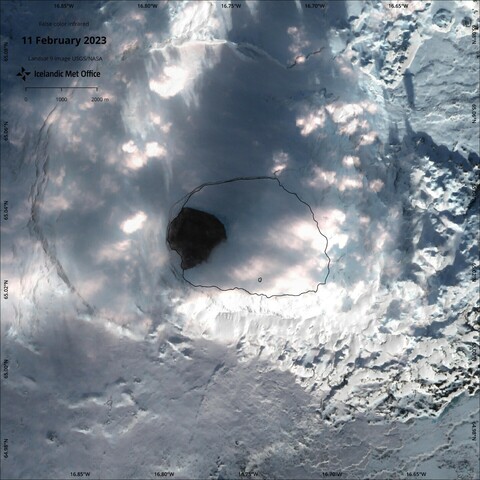
The crater lake ice on Askja is retreating quite fast according to these 3 recently acquired #sentinel2 and #landsat9 images. Note that this is not unheard of. Happened in 2012 and was observed with #MODIS images.
Ragnar Heiðar Þrastarson · @RagnarHeidar
156 followers · 40 posts · Server mastodon.social
Ragnar Heiðar Þrastarson · @RagnarHeidar
156 followers · 40 posts · Server mastodon.social
GregCocks · @GregCocks
105 followers · 120 posts · Server techhub.social
Linkages Between GRACE Water Storage, Hydrologic Extremes, And Climate Teleconnections In Major African Aquifers
--
http://dx.doi.org/10.1088/1748-9326/ac3bfc <-- shared paper
--
#remotesensing #satellite #GRACE #sustainable #development #water #resources #waterresources #watermanagement #waterconservation #hydrology #resources #model #modeling #climatechange #waterstorage #watersecurity #MODIS #landcover #vegetation #irrigation #agriculture #cropland #change #future #management #droughts #floods #climateresilience #sustainabledevelopment
#remotesensing #satellite #grace #sustainable #development #water #resources #waterresources #watermanagement #waterconservation #hydrology #model #modeling #climatechange #waterstorage #watersecurity #modis #landcover #vegetation #irrigation #agriculture #cropland #change #future #management #droughts #floods #climateresilience #sustainabledevelopment

BKG · @BKG
1476 followers · 125 posts · Server social.bund.de
❄️ An wie vielen Tagen im Jahr liegt in Europa #Schnee? Beantworten kann das die #GlobalSnowPack #Schneebedeckung|skarte des @DLR im Geoportal.de:
➡️ https://geoportal.de/map.html?preset=hnJBzx1tQrouGD6by5RutduxexhEYRYF0HV7RtpeTu4
#schnee #globalsnowpack #schneebedeckung #klimawandel #fernerkundung #modis #opendata