
GregCocks · @GregCocks
682 followers · 566 posts · Server techhub.social
Coastal Storm Modeling System (CoSMoS) [USGS]
--
https://www.usgs.gov/centers/pcmsc/science/coastal-storm-modeling-system-cosmos <-- project web page
--
H/T @Anthro #GIS #spatial #mapping #coastal #storm #modeling #CoSMoS #model #spatialanalysis #extremeweather #spatialanalysis #spatiotemporal #prediction #hindcast #mitigation #planning #climate #climatechange #naturalhazard #emergencyresponse #emergencypreparedness #emergencymanagement #risk #hazard #publicsafety #stormdamage #stormsurge #stormpreparedness #flood #flooding #coastalflooding #remotesensing #hydrospatial #water #hydrology #hydrography #topobathy #SLR #sealevelrise #urbanplanning
#gis #spatial #mapping #coastal #storm #modeling #cosmos #model #spatialanalysis #extremeweather #spatiotemporal #prediction #hindcast #mitigation #planning #climate #climatechange #naturalhazard #emergencyresponse #emergencypreparedness #emergencymanagement #risk #hazard #publicsafety #stormdamage #stormsurge #stormpreparedness #flood #flooding #coastalflooding #remotesensing #hydrospatial #water #hydrology #hydrography #topobathy #slr #sealevelrise #urbanplanning
GregCocks · @GregCocks
675 followers · 564 posts · Server techhub.social
Flood Protection Based On Historical Records Is Flawed – We Need A Risk Model Fit For Climate Change
--
https://theconversation.com/flood-protection-based-on-historical-records-is-flawed-we-need-a-risk-model-fit-for-climate-change-212454 <-- shared technical article
--
#GIS #spatial #mapping #water #hydrospatial #hydrology #flood #flooding #model #modeling #planning #mitigation #naturalhazard #humanimpacts #climatechange #extremeweather #regulations #prediction #floodengineering #floodrisk #floodriskassessment #assessment #risk #hazard #riskassessment #floodmanagement #floodprotection #floodsafety #publicsafety #spatialanalysis #spatiotemporal #weatherforecast #climatechangesolutions #climateadaptation
#gis #spatial #mapping #water #hydrospatial #hydrology #flood #flooding #model #modeling #planning #mitigation #naturalhazard #humanimpacts #climatechange #extremeweather #regulations #prediction #floodengineering #floodrisk #floodriskassessment #assessment #risk #hazard #riskassessment #floodmanagement #floodprotection #floodsafety #publicsafety #spatialanalysis #spatiotemporal #WeatherForecast #climatechangesolutions #climateadaptation
GregCocks · @GregCocks
590 followers · 527 posts · Server techhub.social
GIS Powers Innovative Action Among State And Local Governments
--
https://www.govtech.com/analytics/gis-powers-innovative-action-among-state-and-local-governments <-- shared technical article
--
#GIS #spatial #mapping #stategovernment #localauthorities #localgov #localgovernment #localgovernments #government #governmentagencies #usecase #appliedscience #appliedtechnology #examples #publicsafety #publichealth #water #hydrology #waterresources #disasterriskreduction #disasterresponse #watermanagement #wildfire #wildfireresponse #wildfiremitigation #naturalhazard #planning #urbanplanning #transportation #infrastructure #community #communityplanning #communityhealth #taxpayers #taxpayerservices #spatialanalysis #environment #ecosystems #climatechange
#gis #spatial #mapping #StateGovernment #localauthorities #localgov #localgovernment #localgovernments #government #governmentagencies #usecase #appliedscience #appliedtechnology #examples #publicsafety #publichealth #water #hydrology #waterresources #DisasterRiskReduction #disasterresponse #watermanagement #wildfire #wildfireresponse #wildfiremitigation #naturalhazard #planning #urbanplanning #transportation #infrastructure #community #communityplanning #communityhealth #taxpayers #taxpayerservices #spatialanalysis #Environment #ecosystems #climatechange
GregCocks · @GregCocks
583 followers · 522 posts · Server techhub.social
Mountains Are Collapsing - A Swiss Mountain Peak Fell Apart, Sending 3.5 Million Cubic Feet Of Rock Into The Valley Below - Scientists Warn Climate Change Could Make More Mountains Crumble.
--
https://www.businessinsider.com/mountains-switzerland-collapsing-from-permafrost-melt-2023-8 <-- shared media article
--
#GIS #spatial #mapping #model #modeling #prediction #geology #engineeringgeology #massmovement #global #landslide #debrisflow #mudslide #mountain #cryosphere #glacier #snow #ice #permafrost #water #hydrology #rockfall #EuropeanAlps #europe #SouthernAlps #newzealand #andes #peru #indigeneous #firstnation #risk #hazard #publicsafety #climate #melting #snowandicemanagement #climatechange #landforms #change #geomorphology #globalwarming #IPCC #naturalhazard #geologichazards
#gis #spatial #mapping #model #modeling #prediction #geology #engineeringgeology #massmovement #global #landslide #debrisflow #mudslide #mountain #cryosphere #glacier #snow #ice #permafrost #water #hydrology #rockfall #europeanalps #Europe #southernalps #newzealand #Peru #indigeneous #firstnation #risk #hazard #publicsafety #climate #melting #snowandicemanagement #climatechange #landforms #change #geomorphology #globalwarming #ipcc #naturalhazard #geologichazards #andes
GregCocks · @GregCocks
575 followers · 510 posts · Server techhub.social
Hawaii Fire - Maps And Before And After Images Reveal Maui Devastation
--
https://www.bbc.com/news/world-us-canada-66465570 <-- shared media article
--
#GIS #spatial #mapping #maps #imagery #satellite #remotesensing #hawaii #hawaiian #wildfires #wildfire #bushfire #naturalhazard #emergencyresponse #emergencymanagement #wildfiresafety #HawaiiWildfires #HawaiiWildfire #wildfireupdate #Lahaina #LahainaFires #LahainaHawaii #naturaldisasters #maui #mauifires #mauiwildfires #publicsafety #publichealth #communitysafety #gischat
#gis #spatial #mapping #Maps #imagery #satellite #remotesensing #hawaii #hawaiian #wildfires #wildfire #bushfire #naturalhazard #emergencyresponse #emergencymanagement #wildfiresafety #hawaiiwildfires #hawaiiwildfire #wildfireupdate #lahaina #lahainafires #lahainahawaii #naturaldisasters #maui #mauifires #mauiwildfires #gischat #publicsafety #publichealth #communitysafety
GregCocks · @GregCocks
544 followers · 488 posts · Server techhub.social
First-Ever Award For Natural Resource Restoration By FEMA's Hazard Mitigation Program
--
https://coralreef.noaa.gov/issues/nature_based_restoration.html <-- shared technical article
--
#GIS #spatial #mapping #puertorico #coral #hurricane #hurricanemaria #naturalhazard #naturaldisasters #mitigation #spatialanalysis #hazardmitigation #fema #coralreefs #coralrestoration #coraldisease #earthquakes #storm #stormsurge #extremeweather #stonycoral #restoration #sanjuan #naturalresource #coast #coastal #coastalengineering #coastalprotection #coastalcommunities #funding #waveenergy #artificialreef #marine #nearshore #shoreline #currents
@femaregion2 @usgs
#gis #spatial #mapping #PuertoRico #coral #hurricane #hurricanemaria #naturalhazard #naturaldisasters #mitigation #spatialanalysis #hazardmitigation #fema #coralreefs #coralrestoration #coraldisease #earthquakes #storm #stormsurge #extremeweather #stonycoral #restoration #sanjuan #naturalresource #coast #coastal #coastalengineering #coastalprotection #coastalcommunities #funding #waveenergy #artificialreef #marine #nearshore #shoreline #currents
GregCocks · @GregCocks
538 followers · 483 posts · Server techhub.social
Becoming A NWCG Geographic Information Systems Specialist (GISS) Trainee With The National Wildfire Coordinating Group (NWCG)
--
https://www.nwcg.gov/committees/geospatial-subcommittee/becoming-a-giss <-- technical resource for potential GISS trainees
--
https://www.nwcg.gov/positions/giss <-- GISS position description
--
https://www.nwcg.gov/ <-- National Wildfire Coordinating Group (NWCG) home page
--
#GIS #spatial #mapping #trainee #specialist #opportunity #NationalWildfireCoordinatingGroup #NWCG #GISS #wildfire #emergencyresponse #emergency #naturalhazard #spatialanalysis #emergencymanagement #training #background #incident #management
#gis #spatial #mapping #trainee #specialist #opportunity #nationalwildfirecoordinatinggroup #nwcg #giss #wildfire #emergencyresponse #emergency #naturalhazard #spatialanalysis #emergencymanagement #training #background #incident #management

Niklas Jordan 🌳 🌋 🌍 🛰 · @niklas
449 followers · 1500 posts · Server niklas.social🚨 #Disaster and #NaturalHazard alerts needed?
I developed a bot that provides near-realtime updates on #NaturalHazards worldwide.
Using data feeds from the United Nations and European Commission, it offers timely notifications within a 5-minute interval concerning #earthquakes, #tsunamis, #volcanos, #floods, and #wildfires.
👉 Follow here: https://niklas.social/@disasters
Data is coming from @kontur and GDACS.
#wildfires #floods #volcanos #tsunamis #earthquakes #NaturalHazards #naturalhazard #disaster
GregCocks · @GregCocks
394 followers · 427 posts · Server techhub.social
Catastrophic Beach Sand Losses Due To Erosion From Predicted Future Sea Level Rise (0.5–1.0 M), Based On Increasing Submarine Accommodation Spaces In The High-Wave-Energy Coast Of The Pacific Northwest, Washington, Oregon, And Northern California, USA
--
https://doi.org/10.1016/j.margeo.2021.106555 <-- shared paper
--
H/T @Anthro
#GIS #spatial #mapping #model #modeling #sampling #coast #coastline #climatechange #energy #future #erosion #sealevelrise #sealevel #SLR #washington #oregon #nocal #pnw #pacificnorthwest #beaches #coastalprotection #coastalimpacts #impacts #stormsurge #beacherosion #storm #stormsurge #extremeweather #ocean #marine #hydrospatial #sediment #loss #sedimentology #sedimentation #longshoredrift #estuary #estuarine #river #beachloss #naturalhazard #ecosystem #environment
#gis #spatial #mapping #model #modeling #sampling #coast #coastline #climatechange #energy #future #erosion #sealevelrise #sealevel #slr #Washington #oregon #nocal #pnw #pacificnorthwest #beaches #coastalprotection #coastalimpacts #impacts #stormsurge #beacherosion #storm #extremeweather #ocean #marine #hydrospatial #sediment #loss #sedimentology #sedimentation #longshoredrift #Estuary #estuarine #river #beachloss #naturalhazard #ecosystem #Environment
GregCocks · @GregCocks
388 followers · 414 posts · Server techhub.social
The Best And Worst Case Scenarios For Sea Level Rise
--
https://www.theguardian.com/environment/2023/jun/26/its-absolutely-guaranteed-the-best-and-worst-case-scenarios-for-sea-level-rise <-- shared media article
--
#GIS #spatial #mapping #model #modeling #hydrology #water #hydrospatial #spatiotemporal #spatialanalysis #global #sealevel #sealevelrise #SLR #india #london #china #mumbai #bangladesh #NYC #newyork #newyorkcity #cities #megacities #impacts #coast #coastal #flood #flooding #stormsurge #infrastructure #climatechange #extremeweather #erosion #deposition #sedimentation #salinity #groundwater #groundwaterintrusion #groundwatersalinity #subsidence #precipitation #rainfall #storms #geology #engineeringgeology #naturalhazard #cyclone #hurricanes #economic #economy #mitigation #costs #publicsafety #publichealth #coastalresilience #coastalcommunities #coastalengineering #coastline #coastalprotection #future #change
#gis #spatial #mapping #model #modeling #hydrology #water #hydrospatial #spatiotemporal #spatialanalysis #global #sealevel #sealevelrise #slr #india #london #China #mumbai #Bangladesh #nyc #NewYork #newyorkcity #cities #megacities #impacts #coast #coastal #flood #flooding #stormsurge #infrastructure #climatechange #extremeweather #erosion #deposition #sedimentation #salinity #groundwater #groundwaterintrusion #groundwatersalinity #subsidence #precipitation #rainfall #storms #geology #engineeringgeology #naturalhazard #cyclone #hurricanes #economic #economy #mitigation #costs #publicsafety #publichealth #coastalresilience #coastalcommunities #coastalengineering #coastline #coastalprotection #future #change
GregCocks · @GregCocks
291 followers · 379 posts · Server techhub.social
NOAA And NSF To Create Research Center In Response To Insurance Industry Climate Needs
--
https://www.noaa.gov/stories/noaa-and-nsf-to-create-research-center-in-response-to-insurance-industry-climate-needs <-- shared article
--
#GIS #spatial #mapping #model #modeling #climatechange #business #data #future #research #insuranceindustry #property #insurance #building #science #events #risk #hazard #disaster #extremeweather #extremeheat #naturalhazard #economy #economicimpacts #publicsafety #damage #impact #impactassessment #climate #weather #water #hydrology
@noaa #NSF #NOAA
#gis #spatial #mapping #model #modeling #climatechange #business #data #future #research #insuranceindustry #property #insurance #building #science #events #risk #hazard #disaster #extremeweather #extremeheat #naturalhazard #economy #economicimpacts #publicsafety #damage #impact #impactassessment #climate #weather #water #hydrology #nsf #noaa
GregCocks · @GregCocks
233 followers · 293 posts · Server techhub.social
Climate Change And Crumbling Infrastructure Create A ‘Perfect Storm’ For Americans Living In Flood Zone
--
https://thehill.com/opinion/energy-environment/3978721-climate-change-and-crumbling-infrastructure-create-a-perfect-storm-for-americans-living-in-flood-zones/ <-- shared article
--
https://doi.org/10.1038/s41893-019-0437-5 <-- shared paper
--
#GIS #spatial #mapping # #infrastructure #realestate #sustainability #climatechange #people #development #future #property #tax #maintenance #engineers #concrete #work #model #modeling #flood #flooding #naturalhazard #naturalhazards #naturaldisaster #river #rivercontrol #floodmapping #floodzones #weather #mitigation #floodcontrol #planning #risk #hazard #levees #levee #dam #riverside #oceanside #community #coastalcommunities #coastalengineering #coastalresilience #natural #engineered #floodplains
#gis #spatial #mapping #infrastructure #realestate #sustainability #climatechange #people #development #future #property #tax #maintenance #engineers #concrete #work #model #modeling #flood #flooding #naturalhazard #NaturalHazards #naturalDisaster #river #rivercontrol #floodmapping #floodzones #weather #mitigation #floodcontrol #planning #risk #hazard #levees #levee #dam #riverside #oceanside #community #coastalcommunities #coastalengineering #coastalresilience #natural #engineered #floodplains
GregCocks · @GregCocks
227 followers · 288 posts · Server techhub.social
New Modelling Of West Coast Coastal Inundation Has Immediate Implications [New Zealand]
--
https://www.rnz.co.nz/news/ldr/488720/new-modelling-of-west-coast-coastal-inundation-has-immediate-implications <-- shared article
--
https://ttpp.nz/ <-- Proposed Te Tai o Poutini Plan
--
#GIS #spatial #mapping #newzealand #westcoast #plan #model #modeling #remotesensing #LiDAR #innundation #coastalcommunities #coastal #coast #zoning #flood #flooding #planning #mitigation #risk #hazard #naturalhazard #geology #engineeringgeology #disasterriskreduction #naturalhazards #tsunami #regional #earthquake
#gis #spatial #mapping #newzealand #westcoast #plan #model #modeling #remotesensing #lidar #innundation #coastalcommunities #coastal #coast #zoning #flood #flooding #planning #mitigation #risk #hazard #naturalhazard #geology #engineeringgeology #DisasterRiskReduction #NaturalHazards #tsunami #regional #earthquake

Ilan Kelman · @ilankelman
392 followers · 113 posts · Server mastodon.greenComing soon:
"Environmental Hazards: Assessing Risk and Reducing Disaster" (7th edition).
By Keith Smith, Carina Fearnley, Deborah Dixon, Deanne Bird, and Ilan Kelman.
#DRR #DisastersAreNotNatural #NoNaturalDisasters (so we avoid the phrases #NaturalDisaster #NaturalDisasters) #vulnerability #resilience #DisasterRisk #DisasterRiskReduction #disaster #disasters #NaturalHazard #NaturalHazards #EnvironmentalHazard #EnvironmentalHazards #hazard #hazards #risk #risks
#DRR #DisastersAreNotNatural #nonaturaldisasters #naturalDisaster #naturaldisasters #vulnerability #resilience #DisasterRisk #DisasterRiskReduction #disaster #disasters #naturalhazard #NaturalHazards #environmentalhazard #environmentalhazards #hazard #hazards #risk #risks
GregCocks · @GregCocks
217 followers · 279 posts · Server techhub.social
The Most At-Risk Regions In The World For High-Impact Heatwaves
--
https://phys.org/news/2023-04-global-reveals-countries-record-breaking.html <-- shared article
--
https://www.nature.com/articles/s41467-023-37554-1 <-- shared paper
--
#GIS #spatial #mapping #modeling #model #gischat #climatechange #statistics #geostatistics #climatemodel #extremeweather #heatwaves #heatwave #global #publicsafety #publichealth #excessdeaths #communityimpact #regional #temperature #extremevaluetheory #EVT #wildfires #naturalhazard #policy #policymaking #policymakers
#gis #spatial #mapping #modeling #model #gischat #climatechange #statistics #geostatistics #climatemodel #extremeweather #heatwaves #heatwave #global #publicsafety #publichealth #excessdeaths #communityimpact #regional #temperature #extremevaluetheory #evt #wildfires #naturalhazard #policy #policymaking #policymakers
GregCocks · @GregCocks
207 followers · 263 posts · Server techhub.social
A Framework For Multi-Sensor Satellite Data To Evaluate Crop Production Losses - The Case Study Of 2022 Pakistan Floods
--
https://doi.org/10.1038/s41598-023-30347-y <-- shared paper
--
#GIS #spatial #mapping #pakistan #food #foodsecurity #community #flood #flooding #naturalhazard #disaster #water #hydrology #climatechange #monsoon #rainfall #extremeweather #precipitation #weather #climate #agriculture #losses #crops #Indus #model #modeling #assessement #survey #remotesensing #satellite #Setinel #Sentinel1 #Sentinel2 #GPM #multisensor #gischat #lossanddamage #assets #production
#gis #spatial #mapping #Pakistan #Food #FoodSecurity #community #flood #flooding #naturalhazard #disaster #water #hydrology #climatechange #monsoon #rainfall #extremeweather #precipitation #weather #climate #agriculture #losses #crops #indus #model #modeling #assessement #survey #remotesensing #satellite #setinel #sentinel1 #sentinel2 #gpm #multisensor #gischat #LossAndDamage #assets #production
GregCocks · @GregCocks
138 followers · 157 posts · Server techhub.social
[Global] Volcanic Hazard Maps – IAVCEI Commission On Volcanic Hazards Ad Risks
--
https://volcanichazardmaps.org/ <-- entry point web page
--
https://volcanichazardmaps.org/volcano-map/ <-- interactive map
--
#GIS #spatial #mapping #volcano #volcanic #design #community #research #database #IAVCEI #global #map #hazard #hazards #risk #riskassessment #geology #geologichazard #naturalhazard #hazardmap #engineeringgeology #riskassessment #CVHR #NewZealand #ringoffire #dataset #entrypoint #portal #gischat #IAVCEI
#gis #spatial #mapping #volcano #volcanic #Design #community #research #database #iavcei #global #map #hazard #hazards #risk #riskassessment #geology #geologichazard #naturalhazard #hazardmap #engineeringgeology #cvhr #newzealand #ringoffire #dataset #entrypoint #portal #gischat

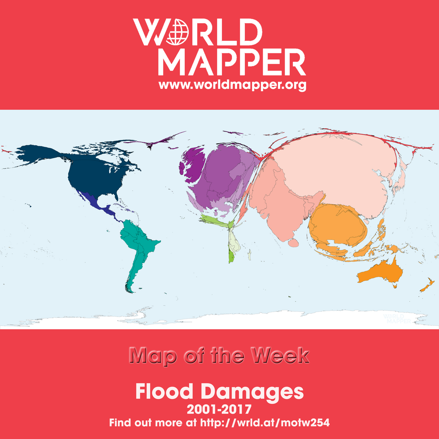
Worldmapper · @worldmapper
71 followers · 15 posts · Server mapstodon.space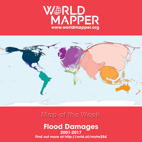
Map of the Week: Flood Damages - find out more at http://wrld.at/motw254 #maps #cartograms #cartography #worldmapper #motw #flood #naturalhazard #hazard #disaster #risk #floodrisk #damages #destruction #climatechange #globalwarming @geography
#maps #cartograms #cartography #worldmapper #motw #flood #naturalhazard #hazard #disaster #risk #floodrisk #damages #destruction #ClimateChange #globalwarming
GregCocks · @GregCocks
123 followers · 145 posts · Server techhub.social
The Copernicus Emergency Management Service Assesses The Damage Caused By The Earthquake In Türkiye
--
https://emergency.copernicus.eu/mapping/node/155224 <-- @ESA bulletin
--
https://emergency.copernicus.eu/mapping/list-of-components/EMSR648 <-- ESA open data
--
#GIS #spatial #mapping #disasterresponse #disastermanagement #opendata #remotesensing #satellite #emergencymanagementservice #EMS #Copernicus #sentential #earthquake #Turkey #Syria #syriaearthquake #turkeyearthquake #naturalhazard #engineeringgeology #survey #assessment #CEMS #emergencymanagement #data #people #publicsafety
#ESA #CopernicusEMS
#gis #spatial #mapping #disasterresponse #DisasterManagement #opendata #remotesensing #satellite #emergencymanagementservice #ems #Copernicus #sentential #earthquake #turkey #Syria #syriaearthquake #turkeyearthquake #naturalhazard #engineeringgeology #survey #assessment #cems #emergencymanagement #data #people #publicsafety #Esa #copernicusems
GregCocks · @GregCocks
77 followers · 91 posts · Server techhub.social
New Report Shows Alarming Changes In The Entire Global Water Cycle
--
https://phys.org/news/2023-01-alarming-entire-global.html <-- article
--
https://wenfo.org/globalwater/ <-- report link
--
#GIS #spatial #mapping #water #hydrology #report #survey #global #data #research #events #africa #australia #pakistan #newzealand #southamerica #drought #flood #flooding #climatechange #watersecurity #naturalhazard #naturalresources #GlobalWaterMonitor #remotesensing #satellite #watercycle #lanina
#gis #spatial #mapping #water #hydrology #report #survey #global #data #research #events #africa #Australia #Pakistan #newzealand #SouthAmerica #drought #flood #flooding #climatechange #watersecurity #naturalhazard #naturalresources #globalwatermonitor #remotesensing #satellite #watercycle #LaNina