
GregCocks · @GregCocks
184 followers · 230 posts · Server techhub.social
Bathymetric Data Viewer [global, NOAA]
--
https://www.ncei.noaa.gov/maps/bathymetry/ <-- spatial open data web portal
--
“NCEI and the IHO Data Center for Digital Bathymetry (DCDB) archive and share depth data acquired by hydrographic, oceanographic, and industry vessels and platforms during surveys or while on passage. These data, which are used in several national and international mapping bathymetry projects, are free to the public with no restrictions…”
#GIS #spatial #mapping #remotesensing #bathmetry #global #opendata #openaccess #download #NCEI #DCBD #NOAA #elevation #sonar #water #hydrography #hydrospatial #webportal #science #spatialanalysis #DEM #data #digital #multibeam #survey #visualisation #BAG #raster #GEBCO #GMRT #IBSCO #GSHHG
@NOAA @NCEI @GEBCO
#gis #spatial #mapping #remotesensing #bathmetry #global #opendata #openaccess #download #ncei #dcbd #noaa #elevation #sonar #water #hydrography #hydrospatial #webportal #science #spatialanalysis #dem #data #digital #multibeam #survey #visualisation #bag #raster #gebco #gmrt #ibsco #gshhg
GregCocks · @GregCocks
177 followers · 213 posts · Server techhub.social
The World in Relief on ETOPO [2022]
--
https://www.ncei.noaa.gov/news/world-relief-etopo <-- shared article
--
https://www.ncei.noaa.gov/products/etopo-global-relief-model <-- open data access
--
#GIS #spatial #mapping #remotesensing #opendata #openaccess #NCEI #ETOPO #topography #elevation #bedrock #icesurface #ice #hydrospatial #bathymetry #topobathy #ETOPO2022 #model #modeling #global #earth #wholeearth #gischat #noaa #NCEI
@NOAA @NCEI
#gis #spatial #mapping #remotesensing #opendata #openaccess #ncei #etopo #topography #elevation #Bedrock #icesurface #ice #hydrospatial #bathymetry #topobathy #etopo2022 #model #modeling #global #earth #wholeearth #gischat #noaa
GregCocks · @GregCocks
177 followers · 210 posts · Server techhub.social
Improving Coastal Resiliency With Digital Elevation Models [NOAA / NCEI]
--
https://www.ncei.noaa.gov/news/improving-coastal-resiliency-digital-elevation-models <-- shared article
--
https://www.ncei.noaa.gov/maps/bathymetry/ <-- NOAA NCEI Bathymetry Viewer
--
https://coast.noaa.gov/dataviewer/#/lidar/search/ <-- NOAA Office for Coastal Management’s Digital Coast: Data Access Viewer
--
#GIS #spatial #mapping #Oceans #Bathymetry #Maps #DataVisualization #Models #modeling #environmental #water #hydrology #hydrospatial #hydrography #bathymetry #topobathy #coast #coastal #climatechange #resiliency #mitigation #planning #prediction #elevation #DEM #flooding #sealevelrise #SLR #sealevel #NCEI #NOAA #USGS #CUDEMS #ETOPO #event #hazard #tsunami #remotesensing #extremeweather #hurricane #planning #spatialanalysis #coastalresilience #coastalcommunities #coastaldesign #stormsurge
#remotesensing #gis #spatial #mapping #oceans #bathymetry #Maps #datavisualization #models #modeling #environmental #water #hydrology #hydrospatial #hydrography #topobathy #coast #coastal #climatechange #resiliency #mitigation #planning #prediction #elevation #dem #flooding #sealevelrise #slr #sealevel #ncei #noaa #usgs #cudems #etopo #event #hazard #tsunami #extremeweather #hurricane #spatialanalysis #coastalresilience #coastalcommunities #coastaldesign #stormsurge

Drought Center · @droughtcenter
88 followers · 75 posts · Server mastodon.world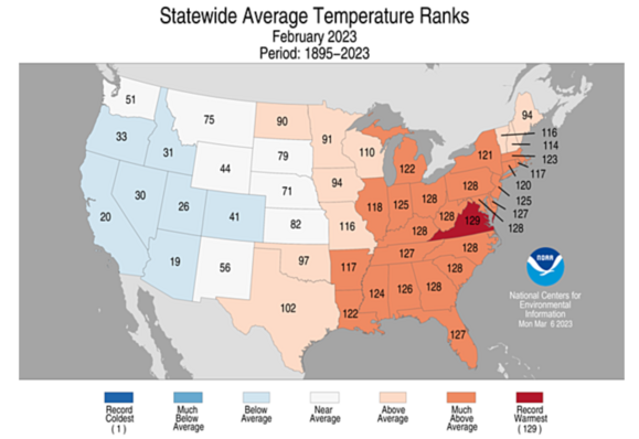
It was a hot and dry month for most of the eastern U.S., according to the latest #NOAA #NCEI #climate rankings.
It was cold out #West, but, back East, 15 states had Februarys in their top-5 warmest. #Virginia had its warmest February on record. Meanwhile, the #Midwest was unusually wet this month, but #NewEngland was bone dry. Precipitation was mixed elsewhere.
#noaa #ncei #climate #West #virginia #Midwest #newengland #science #weather #drought #droughtmonitoring #vawx

beSpacific · @bespacific
355 followers · 534 posts · Server newsie.socialVia NOAA note this is a web page download & PDF data before it disappears - The U.S. has sustained 341 weather and climate disasters since 1980 where overall damages/costs reached or exceeded $1 billion (including CPI adjustment to 2022). The total cost of these 341 events exceeds $2.475 trillion. #ClimateDisasters #Economy #Insurance #infrastructure NOAA National Centers for Environmental Information #NCEI U.S. Billion-Dollar Weather and Climate Disasters (2023). #NOAA https://www.ncei.noaa.gov/access/billions/
#climatedisasters #economy #insurance #infrastructure #ncei #noaa

legraLeGra · @atthenius
844 followers · 1277 posts · Server fediscience.orgClimate researchers from NASA & NOAA will release their annual assessments of global #temperatures and discuss the major #climate trends of 2022 at 11 a.m. EST Thursday, Jan. 12 #climatechange
NASA will stream audio of the briefing on the agency’s website:
Bill Nelson, #NASA Administrator
Gavin Schmidt, director, ##NASAGISS
Sarah Kapnick, chief scientist, #NOAA
Russ Vose, chief of the analysis and synthesis branch, NOAA #NCEI
https://www.nasa.gov/press-release/nasa-noaa-to-announce-2022-global-temperatures-climate-conditions
#ncei #noaa #nasagiss #nasa #climatechange #Climate #temperatures

Ian Brown · @ianbrown
291 followers · 508 posts · Server mastodonapp.uk
'2022 tied 2017 and 2011 for the third highest number of billion-dollar disasters. 2022 was also third highest in total costs (behind 2017 and 2005), with a price tag of at least $165.0 billion. This total annual cost may rise by several billion when we’ve fully accounted for the costs of the December 21-26 Central and Eastern winter storm/cold wave.'
'2022 was also deadly, in that the 18 events of 2022 caused at least 489 direct or indirect fatalities.'