
pyQGIS · @pyQGIS
45 followers · 123 posts · Server social.anoxinon.de

GregCocks · @GregCocks
211 followers · 269 posts · Server techhub.social
10 Common Vegetation Indices And Their Applications In Remote Sensing
--
https://tnmthai.medium.com/10-common-vegetation-indices-and-their-applications-in-remote-sensing-4bd9bfdae3f3 <-- shared link to their guide/tutorial
--
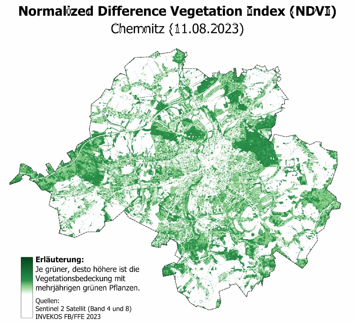
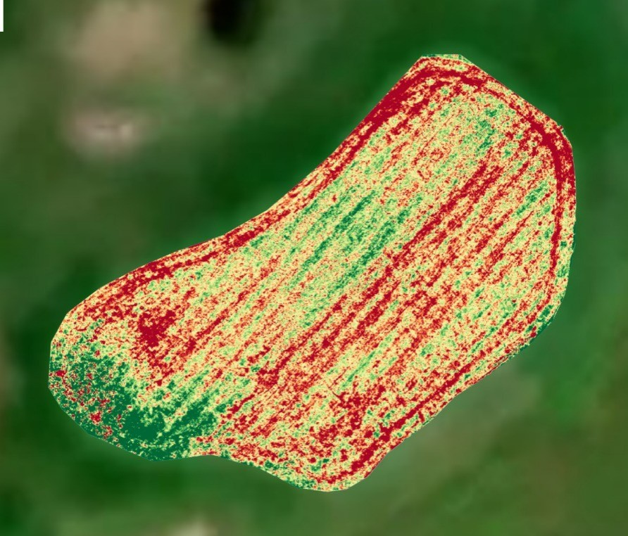
“Vegetation indices are mathematical expressions that help to quantify the health, density, and vigor of vegetation from remote sensing data. They are widely used in various applications such as agriculture, forestry, ecology, and land management. Here are ten common vegetation indices and their applications:..”
1. NDVI
2. EVI
3. SAVI
4. TVI
5. GNDVI
6. MASVI
7. NDII
8. CVI
9. REVI
10. PRI
#GIS #spatial #mapping #tutorial #remotesensing #vegetation #index #indices #earthobservation #coding #NDVI #EVI #SAVI #TVI #GNDVI #MASVI #NDII #CVI #REVI #PRI #soil #health #planthealth #agriculture #data #management #plants #plantlife #survey #spatialanalysis
#gis #spatial #mapping #tutorial #remotesensing #vegetation #index #indices #earthobservation #coding #ndvi #evi #savi #tvi #gndvi #masvi #ndii #cvi #revi #pri #soil #Health #PlantHealth #agriculture #data #management #Plants #plantlife #survey #spatialanalysis
GregCocks · @GregCocks
203 followers · 261 posts · Server techhub.social
Dynamic World, Near Real-Time Global 10 Metre Land Use Land Cover Mapping
--
https://doi.org/10.1038/s41597-022-01307-4 <-- shared paper
--
#GIS #spatial #mapping #landcover #processeddata #deeplearning #AI #landuse #remotesensing #global #timelag #automation #NRT #LULC #NLCD #satellite #Sentinel #Sentinel2 #DynamicWorld #NDVI #machinelearning #artificialintelligence
#gis #spatial #mapping #landcover #processeddata #deeplearning #AI #landuse #remotesensing #global #timelag #automation #NRT #lulc #nlcd #satellite #sentinel #sentinel2 #dynamicworld #ndvi #machinelearning #artificialintelligence
Ghetti · @ghetti
0 followers · 14 posts · Server universeodon.com“What about using imagery?” Well that sounds sexy and all but I just complained about variables influencing a dataset that starts from topography and texture (modeling water). Imagery is great for in season applications (make a spatial map of what’s happening right now) but using it for predictive uses feels icky and I’d rather use multi years worth of historical production maps. #agriculture #VRfert #Ndvi

KAP Jasa - kite team Slovenia · @kap_jasa
33 followers · 20 posts · Server mastodon.socialA long kite aerial archaeology story - a lost church found, a landscape palimpsest decyphered:
https://kapjasa.si/en/a-landscape-palimpsest-and-a-lost-church/
#kiteaerialphotography #kite #flying #aerial #KAP #archaeology #history #Karst #Kras #church #nearinfrared #NIR #NDVI #Gorjansko #Margareta #LIDAR #Slovenia
#kiteaerialphotography #kite #flying #aerial #kap #archaeology #history #karst #KRAS #church #nearinfrared #NIR #ndvi #gorjansko #Margareta #lidar #slovenia
Drone Luis · @droneluis
0 followers · 4 posts · Server mstdn.social
Golf turf analysis using #multispectralimaging . Ideal to create prescription maps for variable rate application.
#ndvi #vegetationindex #turfmanagement #golfcourse
#GolfCourse #turfmanagement #vegetationindex #ndvi #multispectralimaging
ClearSkyImaging · @uk_csi
90 followers · 141 posts · Server mstdn.socialWe can use drones to check on the health of crops, or in this case, the health of the grass on golf courses.
#drones #ndvi #crops #crophealth #agriculture #drones4good #uav #uas #golf #golfcourse
#GolfCourse #golf #uas #uav #drones4good #agriculture #crophealth #crops #ndvi #Drones

· @commonchaffinch
4 followers · 47 posts · Server qoto.org#remote_sensing
#vegetation_index
#ndvi
#evi
#review
2022. Dalei Hao from Pacific Northwest National Lab, and coauthors.
Satellite-measured spectral reflectance is co-determined by leaf reflectance, background soil reflectance, canopy structure, and sensor geometry.
The below are broad-band vegetation indices for measuring vegetation structure:
* NDVI is simple and requires only the NIR and Red band, but sensitive to the soil background variations and insensitive to dense vegetation.
* EVI requires the blue band as well as the NIR and Red band, but minimizes both soil and atmospheric effects and is more sensitive to dense vegetation than NDVI. However, EVI is sensitive to the BRDF (bidirectional reflectance distribution function, related to the sun-target-sensor geometry) effect.
** The blue band helps remove atmospheric effects. With the advancement in atmospheric correction algorithms, EVI2 is developed and requires only the red and NIR bands.
* PPI (Plant Phenology Index) uses red and NIR bands, and is nearly linearly correlated with green LAI. But PPI is moderately sensitive to soil brightness.
** Still, the original paper (https://www.sciencedirect.com/science/article/abs/pii/S0034425714002557?via%3Dihub) seems to suggest it is more useful for GPP than LAI.
* NIRv is not sensitive to soil background variations, but sensitive to the BRDF effect.
Narrow-band vegetation indices can measure (1) biochemical properties, (2) physiological properties (e.g. photosynthetic light-use efficiency, or environmental stress). These indices make use of measurements made at specific wavelengths. The former includes indices for chlorophyll content, carotenoid content, normalized difference water index (vegetation water condition), land surface water index (vegetation water condition), normalized difference lignin index, etc. The latter include the PRI (photochemical reflectance index) and CCI (chlorophyll/carotenoid index), etc.
Artefacts in vegetation indices arise from (1) differences between sensors, (2) satellite product versions, (3) atmospheric and directional corrections, (3) compositing algorithms, (4) application of different levels of quality assurance and quality control flags. Some notable known facts are:
(1) AVHRR and MODIS NDVI time series can show trends in opposite directions.
(2) NDVI values are substantially different between AVHRR, MODIS, and VIIRS. The level of the differences varies across land cover types
(3) Products from AVHRR and MODIS have instrumental drifts. AVHRR products, especially, are from a series of satellites. The NDVI values from AVHRR aboard NOAA-11 were higher than the values measured by other AVHRR sensors. The trends in the NIRv values are not sufficiently trustworthy to measure the global CO2 fertilization effect. The MODIS Collection 5 and Collection 6 products have inconsistent greening trends. The MODIS Terra satellite suffers from sensor degradation, more so in the blue band than in the longer-wavelength bands, resulting in artificial negative drifts in NDVI and EVI values in Collection 5. The Collection 6 products remedied the sensor degradation problem.
(4) MODIS-based NDVI exhibited increasing trend during 2001-2016, but GIMMS-based NDVI showed the opposite trend, especially after 2012. This highlights uncertainty in global greening.
(5) VIP3 and LTDR4 NDVI, and the GIMMS-3g NDVI in the more humid areas, have orbital drift effects.
(6) SPOT-VGT NDVI time series have an abrupt jump at the shift from VGT-1 to VGT-2.
(7) As a rule of thumb, ratio-based indices (e.g. NDVI) have smaller biases than straight indices (e.g. NIRv = NDVI*NIR), because of the cancellation between denominator and numerator. Therefore, it is especially important to check for instrumental drifts in the latter.
(8) BRDF effect does not influence the long-term trends or interannual variations, since the sun returns its orbit every year. But it affects phenology. Single-season analysis should be rigorously corrected for BRDF [refs 64, 122, 123, 124]. Landsat's viewing angle is relatively restricted (+/-7.5 degrees from nadir), but other sensors like AVHRR and MODIS must be corrected for this effect.
(9) GIMMS-3g datasets used relatively old compositing algorithm (maximum value compositing). The MOD13A1 and MYD13A1 used a newer one. The MCD43A4 C6 product used a even newer one and removed the view-angle effects; the angle was always set at the local solar noon zenith angle. GIMMS-3g also had only limited atmospheric correction.
Soil artefacts are worse in sparsely vegetated regions (<50% cover, or LAI ~= 1). Snow and ice lead to discrepancies in temperate regions. Topograph also create artefacts, but decreases with spatial averaging.
Finally, the pixels can be mismatched with the actual point on the ground. MODIS has accurate geolocation, but the offset can still be as much as 0.5 pixel between scenes. This is a problem for single-site study. Hyper-resolution (<3m) remote sensing products have their own problems because there can be shadows.
There is need to more extensively measure reflected radiation from vegetation to verify the remote sensing products. There is also much uncertainty in greening.
#vegetation_index #evi #remote_sensing #ndvi #review

I.M.V.E.C. · @imvectech
852 followers · 2060 posts · Server qoto.org
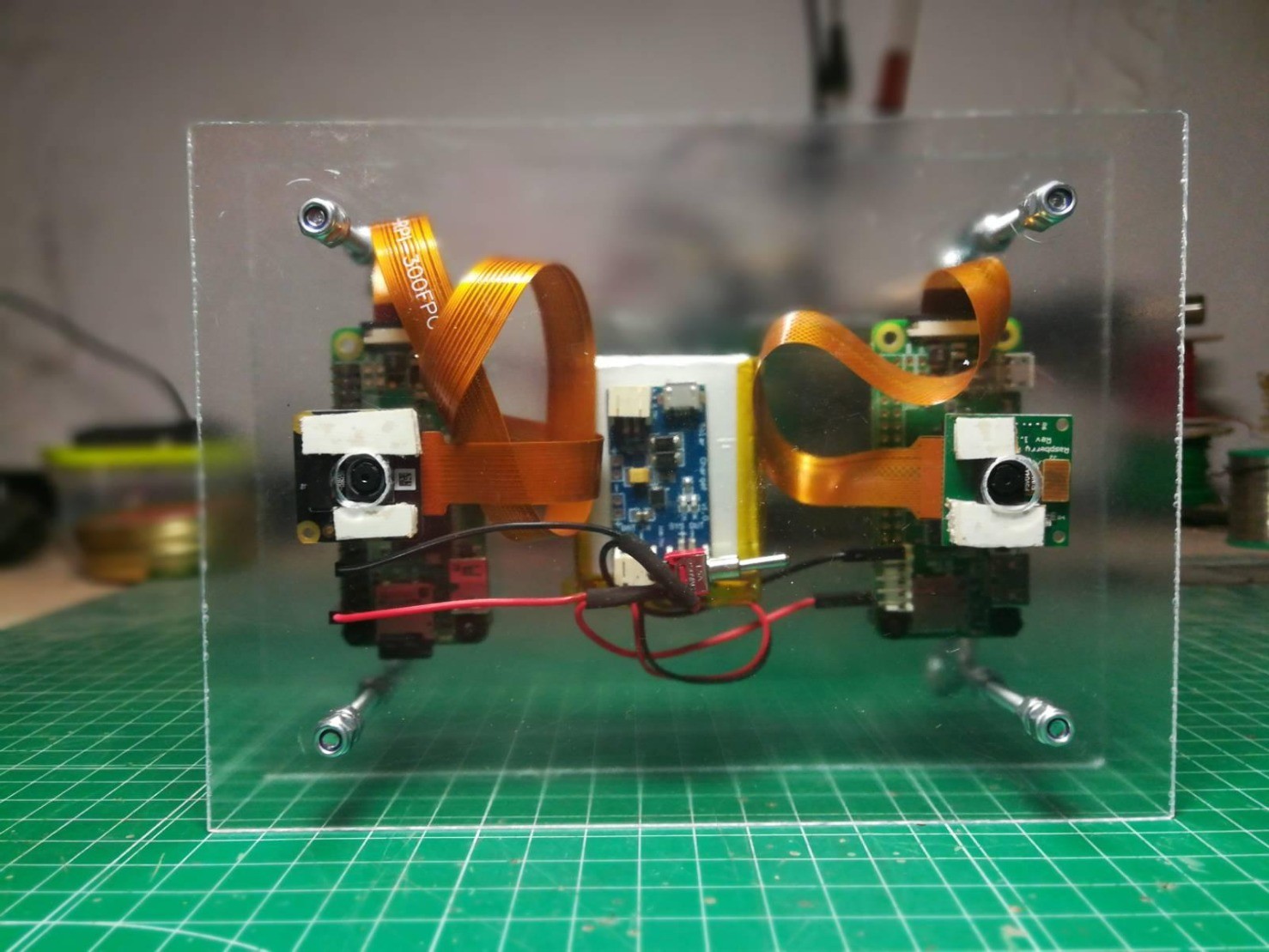
La #PicavetPi es una cámara estabilizada para fotografía con cometas que lleva dos lentes, una para fotografia RGB y otra para #NDVI.
Muy pronto en https://regist.ro.
#PicavetPi #ndvi #raspberrypi #AutodefensaVecinal #kap #picavet

xose quiroga · @Xosequiroga
223 followers · 568 posts · Server social.coop
RT @imvectech@twitter.com
Muy contentas de haber participado ayer en la Bienal #CiutatiCiencia junto a la llera del río Besós.
Aqui algunas de las imágenes obtenidas con cometa y cámara #NDVI desarrollada por la comunidad @PublicLab@twitter.com y @Raspberry_Pi@twitter.com.
Muchas gracais por la invitación @josperello@twitter.com!!