GregCocks · @GregCocks
544 followers · 488 posts · Server techhub.socialFirst-Ever Award For Natural Resource Restoration By FEMA's Hazard Mitigation Program
--
https://coralreef.noaa.gov/issues/nature_based_restoration.html <-- shared technical article
--
#GIS #spatial #mapping #puertorico #coral #hurricane #hurricanemaria #naturalhazard #naturaldisasters #mitigation #spatialanalysis #hazardmitigation #fema #coralreefs #coralrestoration #coraldisease #earthquakes #storm #stormsurge #extremeweather #stonycoral #restoration #sanjuan #naturalresource #coast #coastal #coastalengineering #coastalprotection #coastalcommunities #funding #waveenergy #artificialreef #marine #nearshore #shoreline #currents
@femaregion2 @usgs
#gis #spatial #mapping #PuertoRico #coral #hurricane #hurricanemaria #naturalhazard #naturaldisasters #mitigation #spatialanalysis #hazardmitigation #fema #coralreefs #coralrestoration #coraldisease #earthquakes #storm #stormsurge #extremeweather #stonycoral #restoration #sanjuan #naturalresource #coast #coastal #coastalengineering #coastalprotection #coastalcommunities #funding #waveenergy #artificialreef #marine #nearshore #shoreline #currents
AnthropoceneMan · @Anthro
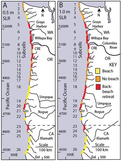
270 followers · 605 posts · Server universeodon.comOne aspect of #Anthropocene #SeaLevelRise will be the loss of #nearshore sands to #sediment sinks. As sea levels rise, less sediment will pass through estuaries to feed beaches, and even though coastal erosion will increase, so will the offshore areas that will trap sediments...as winter profile sandbars become stranded by rising seas.
Figure shows the potential for complete loss of sandy beach areas as well as significant backshore retreat due to sand loss under 0.5 and 1.0 #SLR #PNW #Oregon
#anthropocene #sealevelrise #nearshore #slr #pnw #oregon #sediment
GregCocks · @GregCocks
68 followers · 85 posts · Server techhub.socialSatellite-Derived Bathymetry Online [shared paper]
--
https://ihr.iho.int/articles/satellite-derived-bathymetry-online-validation-study-upscaling-sdb-sdb-potential/ <-- 2022 shared paper
--
https://doi.org/10.3133/sir20185024 <-- 2019 USGS report on the technologies
--
#GIS #spatial #mapping #satellitederivedbathymetry #SDB #validation #coastalmapping #hydrospatial #bathymetry #satellite #remotesensing #elevation #global #survey #EarthObservation #bathymetric #coastal #global #marine #ocean #nearshore #nautical #Seabed2030 #EMODnet #accuracy #precision #vertical #4S #water #hydrology #clarity #nearshore #cloud #programming
#gis #spatial #mapping #satellitederivedbathymetry #sdb #validation #coastalmapping #hydrospatial #bathymetry #satellite #remotesensing #elevation #global #survey #earthobservation #bathymetric #coastal #marine #ocean #nearshore #nautical #seabed2030 #emodnet #accuracy #precision #vertical #4s #water #hydrology #clarity #cloud #programming
rockybandit 🥊 · @rockybandit
148 followers · 543 posts · Server social.chilira.comrockybandit 🥊 · @rockybandit
148 followers · 542 posts · Server social.chilira.comAna Palacio · @anapalacio
1 followers · 1362 posts · Server respublicae.euRT @garrett_geoff: Despite the efforts of the US and other countries to #reshore #nearshore #friendshore production, the #China share of world #exports continues to rise and dwarfs all other countries
#reshore #nearshore #friendshore #China #exports


