
GregCocks · @GregCocks
567 followers · 503 posts · Server techhub.social
Instructional Videos on Using The [USGS’s] National Map [Open Data] Products and Services [3DEP Elevation, Hydrology, etc]
--
https://www.usgs.gov/programs/national-geospatial-program/training <-- shared technical training resource
--
https://www.usgs.gov/programs/national-geospatial-program/national-map <-- background to the USGS’s Accessible National Map Open Data
--
#GIS #spatial #mapping #USGS #opendata #elevation #hydrography #hydrology #NGTOC #NGP #3DEP #3DHP #topoBuilder #USA #gischat #TNM #TheNationalMap #products #services #dataportal #tutorials #tutorial #trainingvideos #videos #learning #continuingeducation #education #educationandtraining #free #videolessons #videolearning #topographic #topographicmaps #instructional
@usgs
#gis #spatial #mapping #usgs #opendata #elevation #hydrography #hydrology #ngtoc #ngp #3dep #3dhp #topobuilder #USA #gischat #tnm #thenationalmap #products #services #dataportal #tutorials #tutorial #trainingvideos #videos #learning #continuingeducation #education #educationandtraining #free #videolessons #videolearning #topographic #topographicmaps #instructional

J9Cody :arcgis: :python: 🛰️ · @J9C
51 followers · 35 posts · Server mapstodon.space
The #USGS National Geospatial Technical Operations Center (#NGTOC) is seeking high school, associate, undergraduate, graduate level student (working towards a degree in Geography) to gain practical experience in using GIS, and analyzing scientific data. NGTOC Office of Operations creates, manages, and delivers #elevation and surface water mapping data in support of The National Map. Please see https://www.usajobs.gov/job/738912900 which closes on 8.9.23. #gischat #hydrology #STEM #mapping
#USGS #ngtoc #elevation #gischat #hydrology #stem #mapping
GregCocks · @GregCocks
453 followers · 459 posts · Server techhub.social
Looking for a role whilst studying?
Several USGS NGTOC job openings for current students. Please share widely!
Denver, CO and Rolla, MO locations, possible opportunities for some telework...
--
https://lnkd.in/eERT4KUc <-- jobs' descriptions and announcement
--
https://lnkd.in/eWAZY4kj <-- details of USGS's NGTOC
--
#GIS #spatial #mapping #gischat #jobannouncement #openings #nowhiring #employmentopportunities #employmentopportunity #students #trainee #traineeship #trainees #USGS #NGTOC #geography #cartography #datascience #spatialanalysis #spatialdata
@usgs
#gis #spatial #mapping #gischat #jobannouncement #openings #nowhiring #employmentopportunities #employmentopportunity #students #trainee #traineeship #trainees #usgs #ngtoc #geography #cartography #datascience #spatialanalysis #spatialdata
GregCocks · @GregCocks
418 followers · 450 posts · Server techhub.social
The USGS Provides Maps & Imagery For Hurricane Response
--
https://www.usgs.gov/news/featured-story/usgs-provides-maps-and-imagery-hurricane-response <-- link to technical article
--
https://apps.nationalmap.gov/event-support-map-hub/ <-- Geospatial Information Response Team (GIRT) hazard USGS The National Map (TNM) page
--
H/T #XanFredricks
“🌊For this hurricane season, the [U.S. Geological Survey (USGS) Geospatial Information Response Team] GIRT has a newly designed, publicly available Event Support Map HUB site that offers access to applications, resources and information for hurricanes and other natural disasters…”
#GIS #spatial #mapping #USGS #NGP #GIRT #EROS #NGTOC #HDDS #3DEP #TheNationalMap #science #maps #imagery #hurricanes #tropicalstorms #hazards #emergencyresponse #disasterresponse #firstresponders #supportmaps #realtimedata #information #response #gischat #appliedscience
@usgs #USGS
#xanfredricks #gis #spatial #mapping #usgs #ngp #girt #eros #ngtoc #hdds #3dep #thenationalmap #science #Maps #imagery #hurricanes #tropicalstorms #hazards #emergencyresponse #disasterresponse #firstresponders #supportmaps #realtimedata #information #response #gischat #appliedscience
GregCocks · @GregCocks
246 followers · 323 posts · Server techhub.social
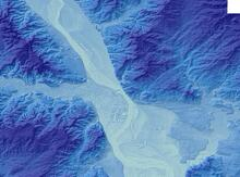
National Hydrography Dataset (NHD) - USGS National Map Downloadable Data Collection
--
https://catalog.data.gov/dataset/national-hydrography-dataset-nhd-usgs-national-map-downloadable-data-collection <-- link to resource and data downloads
--
https://www.usgs.gov/core-science-systems/ngp/national-hydrography <-- link to open hydrology data, USA
--
#GIS #spatial #mapping #gischat #water #hydrology #USGS #NHD #NationalHydrographyDataset #publicdata #opendata #spatialdata #data #digital #network #TNM #NGTOC #NGP #geography #USA #CONUS #Alaska #Hawaii #cartography #appliedscience #spatialanalysis #watermanagement #waterresources #waterinfrastructure
#gis #spatial #mapping #gischat #water #hydrology #usgs #nhd #nationalhydrographydataset #publicdata #opendata #spatialdata #data #digital #network #tnm #ngtoc #ngp #geography #USA #conus #alaska #hawaii #cartography #appliedscience #spatialanalysis #watermanagement #waterresources #waterinfrastructure
GregCocks · @GregCocks
176 followers · 204 posts · Server techhub.socialInterdisciplinary Cartographer/Geographer/Computer Scientist
--
https://www.usajobs.gov/job/713059000 <-- direct link to the listing
--
Come work with me/us! 😊
#GIS #spatial #mapping #job #jobdescription #jobalert #USGS #NGTOC #research #opendata #researcher #federalgovernment #FederalService #USA #gischat #employment #employmentopportunity #employee #cartographer #geographer #computerscientist
[note that I can't supply any specific details beyond what is the listing]
#gis #spatial #mapping #job #jobdescription #jobalert #usgs #ngtoc #research #opendata #researcher #federalgovernment #federalservice #USA #gischat #employment #employmentopportunity #employee #cartographer #geographer #computerscientist