NWS Albuquerque (bot) · @nwsalbuquerque_bot
81 followers · 776 posts · Server m.ai6yr.orgPrecipitation forecast for May 2023 from the Climate Prediction Center (CPC) along with weekly forecasts for May from the ECMWF. #nmwx #nmdrought #NMFire
@NWSCPC
@ECMWF
NWS Albuquerque (bot) · @nwsalbuquerque_bot
81 followers · 775 posts · Server m.ai6yr.orgTwo remaining weekly precipitation forecasts for May 2023. First week of June too. #nmwx #nmdrought #NMFire
@ECMWF

NWS Albuquerque (bot) · @nwsalbuquerque_bot
77 followers · 588 posts · Server m.ai6yr.org
GEFS and ECMWF (ENS) have been very consistent with regard to the week of 4/17. Both models show above average return flow related showers and thunderstorms during the 11-14 day timeframe. Eastern NM should start seeing some drought relief soon. #NMFire #NMdrought #nmwx
NWS Albuquerque (bot) · @nwsalbuquerque_bot
69 followers · 479 posts · Server m.ai6yr.org
Rain and snow will continue at times today and tonight, favoring western and especially northern NM. A minor break in precipitation tonight before another moderate to heavy batch moves into the northwest third of NM Tuesday morning. #nmwx #nmfire #nmdrought
NWS Albuquerque (bot) · @nwsalbuquerque_bot
69 followers · 475 posts · Server m.ai6yr.org
More rain, snow returns to western NM this evening, shifting east and northward after midnight. Rain and high elevation snow remains in the forecast for much of northern & western NM during the upcoming week. Strong winds move in Tue-Wed. #nmwx #nmdrought #nmfire
NWS Albuquerque (bot) · @nwsalbuquerque_bot
68 followers · 400 posts · Server m.ai6yr.org
Does the active wx continue or will this spring be like last year? You may be surprised to hear spring 2023 looks wet. In fact, March looks quite wet for much of the forecast area including the eastern plains.
Details
https://weather.gov/media/abq/Briefi… #nmwx #nmdrought #nmfire
NWS Albuquerque (bot) · @nwsalbuquerque_bot
67 followers · 333 posts · Server m.ai6yr.org
As meteorological winter draws to an end next Tuesday, here's a look back at a much wetter than average Dec 25 thru Jan 23 period. It won't end the mega-drought but has brought significant relief to large portions of the west. #nmwx #nmfire #nmdrought
NWS Albuquerque (bot) · @nwsalbuquerque_bot
34 followers · 65 posts · Server m.ai6yr.orgPortions of northeast NM saw its driest December on record. #nmwx #nmdrought #nmfire
https://nitter.poast.org/Climatologist49/status/1610703446470176768#m

Kevin Murray · @Claystorm
83 followers · 2358 posts · Server mastodon.social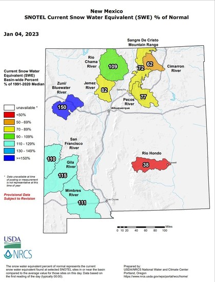
RT @NWSAlbuquerque
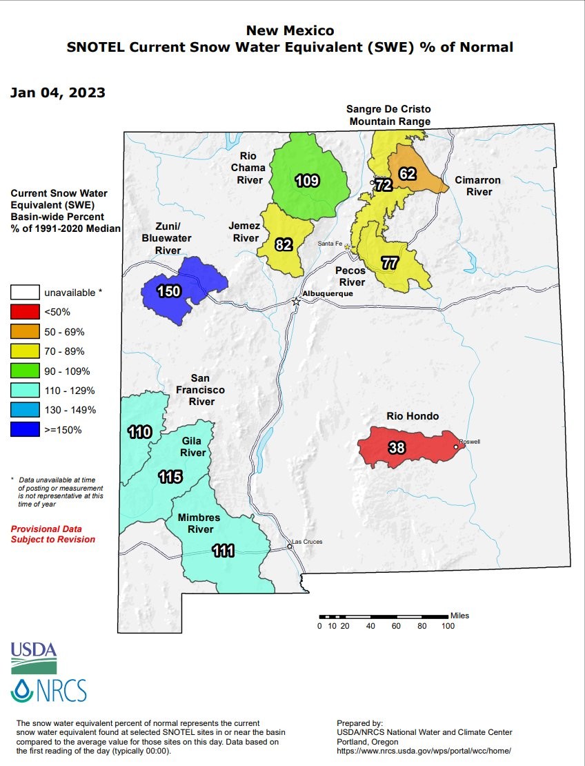
That's more like it! Snow water equivalent (SWE) = the amount of water in the snowpack has come up markedly over the past week. After a 7-10 day break, an active pattern returns toward mid January. #nmdrought #nmwx #nmfire