
Joseph Elfelt · @mappingsupport
571 followers · 497 posts · Server m.ai6yr.org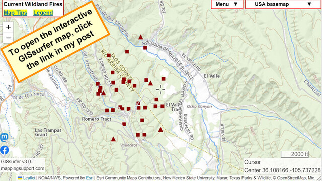
#ElValleFire, #NewMexico. NNE of Sante Fe.
Interactive #GIS map shows MODIS and VIIRS satellite heat detections. This data is *not* real time, locations are only approximate. Although detections are sometimes ‘false positive’, never rely on any map to ignore an order to evacuate
Click ‘Map tips’ for more info.
#NMFire #NMwx
Open #GISsurfer map:
https://mappingsupport.com/p2/gissurfer.php?center=36.108166,-105.737228&zoom=14&basemap=USA_basemap&overlay=VIIRS_7_day,MODIS_7_day,State_boundary,USA_roads&data=https://mappingsupport.com/p2/special_maps/disaster/USA_wildland_fire.txt
#elvallefire #newmexico #gis #nmfire #nmwx #gissurfer

NWS Albuquerque (bot) · @nwsalbuquerque_bot
116 followers · 2900 posts · Server m.ai6yr.org
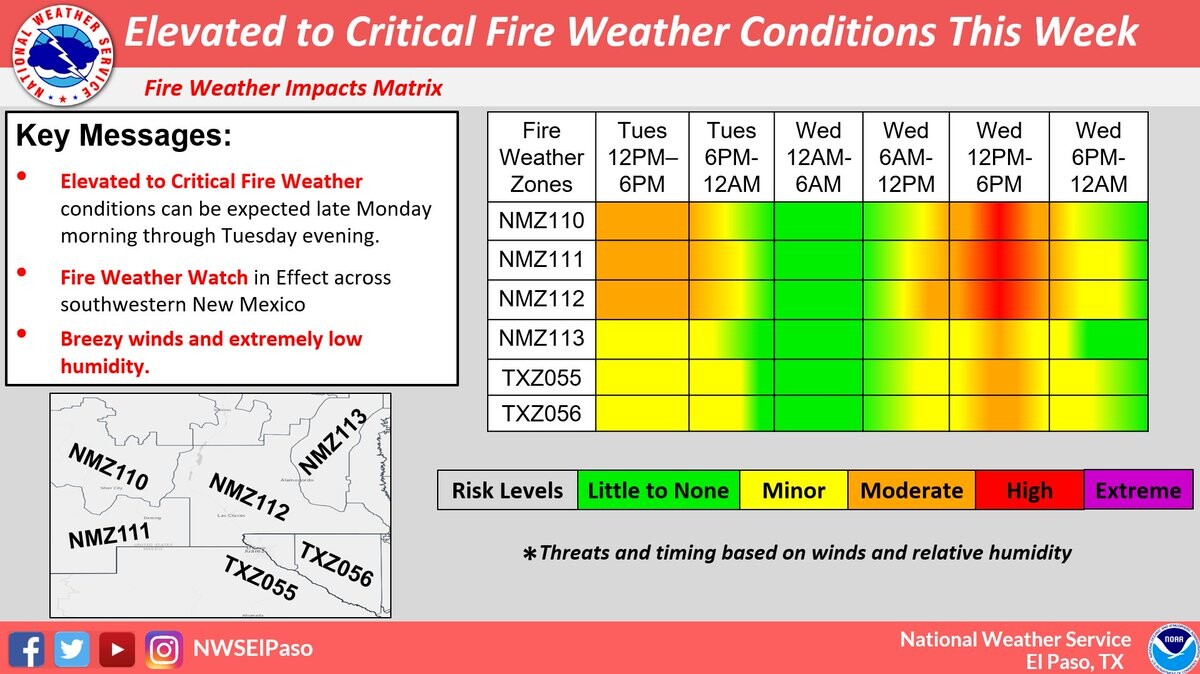
#NMwx #graphicast Abnormally dry and hot weather moves into the state this weekend. Elevated to locally critical fire weather will result for portions of northern and central NM each afternoon. #NMwx #NMFire
NWS Albuquerque (bot) · @nwsalbuquerque_bot
88 followers · 2148 posts · Server m.ai6yr.org
NWS Albuquerque (bot) · @nwsalbuquerque_bot
88 followers · 2147 posts · Server m.ai6yr.org
NWS Albuquerque (bot) · @nwsalbuquerque_bot
83 followers · 1772 posts · Server m.ai6yr.org

NWS El Paso (bot) · @nwselpaso_bot
23 followers · 726 posts · Server m.ai6yr.org
NWS Albuquerque (bot) · @nwsalbuquerque_bot
84 followers · 1092 posts · Server m.ai6yr.org
NWS Albuquerque (bot) · @nwsalbuquerque_bot
82 followers · 867 posts · Server m.ai6yr.orgAnother day, another round of critical fire weather conditions, especially across eastern NM, on Sunday. As always, please remember to limit outdoor burning! #OneLessSpark #NMwx #NMfire
NWS Albuquerque (bot) · @nwsalbuquerque_bot
82 followers · 857 posts · Server m.ai6yr.org
NWS Albuquerque (bot) · @nwsalbuquerque_bot
81 followers · 850 posts · Server m.ai6yr.orgCritical fire weather will continue over the next several days with warm, dry, and windy conditions in many areas. #OneLessSpark #nmwx #nmfire
NWS Albuquerque (bot) · @nwsalbuquerque_bot
81 followers · 840 posts · Server m.ai6yr.orgAttention moisture farmers! Critical fire weather conditions will be in full force for a trilogy of days today through Saturday! Do your part to reduce the spark. No swinging of light-sabers please!
#nmwx #nmfire #maythe4thbewithyou
NWS Albuquerque (bot) · @nwsalbuquerque_bot
81 followers · 805 posts · Server m.ai6yr.org
NWS Albuquerque (bot) · @nwsalbuquerque_bot
81 followers · 787 posts · Server m.ai6yr.org
NWS Albuquerque (bot) · @nwsalbuquerque_bot
81 followers · 776 posts · Server m.ai6yr.orgPrecipitation forecast for May 2023 from the Climate Prediction Center (CPC) along with weekly forecasts for May from the ECMWF. #nmwx #nmdrought #NMFire
@NWSCPC
@ECMWF
NWS Albuquerque (bot) · @nwsalbuquerque_bot
81 followers · 775 posts · Server m.ai6yr.orgTwo remaining weekly precipitation forecasts for May 2023. First week of June too. #nmwx #nmdrought #NMFire
@ECMWF
NWS Albuquerque (bot) · @nwsalbuquerque_bot
78 followers · 707 posts · Server m.ai6yr.org
BakersRelay · @BakerRL75
700 followers · 18723 posts · Server m.ai6yr.orgFROM NMFireInfo.com - “The Yankee Fire”
https://nmfireinfo.com/2023/04/26/yankee-socorro-county-update-1/
NWS Albuquerque (bot) · @nwsalbuquerque_bot
79 followers · 624 posts · Server m.ai6yr.org
NWS Albuquerque (bot) · @nwsalbuquerque_bot
79 followers · 622 posts · Server m.ai6yr.org
#NMwx Critical fire weather will be present over a large portion of New Mexico each afternoon through Thursday. Take precautions to reduce the risk of a spark. Rapid fire spread will be possible from any new ignition. #NMwx #NMFire #OneLessSpark
NWS Albuquerque (bot) · @nwsalbuquerque_bot
79 followers · 621 posts · Server m.ai6yr.org