
GregCocks · @GregCocks
670 followers · 560 posts · Server techhub.social
National Feasibility Study For Flood Hazard Modeling And Mapping At A Regional Scale [RFP, Canada]
--
https://canadabuys.canada.ca/en/tender-opportunities/tender-notice/cb-8664-4812766 <-- request for proposal (RFP) link…
--
[wonderful to see such RFP’s coming out]
#GIS #spatial #mapping #canada #rfp #requestforproposal #flood #flooding #hydrospatial #opportunity #model #modeling #usecase #appliedscience #hydrology #water #risk #hazard #floodhazard #FHIMP #casestudy #casestudies
#NRCan #contract #contracting #contractingopportunities
#gis #spatial #mapping #Canada #rfp #requestforproposal #flood #flooding #hydrospatial #opportunity #model #modeling #usecase #appliedscience #hydrology #water #risk #hazard #floodhazard #fhimp #casestudy #casestudies #nrcan #contract #contracting #contractingopportunities
GregCocks · @GregCocks
405 followers · 436 posts · Server techhub.social
GEO.CA - The Definitive Source For Canada’s Open Geospatial Information
--
https://geo.ca/home/ <-- home page and data portal
--
“[NRCAN has] worked with all levels of [Canadian] government to bring you a digital platform where Canadians can discover, access, analyze and map Canada’s vast geospatial data resources. 🌎🗺️
If you’re interested in urban planning, policy development or tracking outbreaks and monitoring climate change, [their] new site can help you access the data you need to make evidence-based, educated decision-making…”
#GIS #spatial #mapping #Canada #spatialdata #spatialanalysis #Canadian #opendata #dataportal #datadownload #gischat #provinces #dataresources #urbanplanning #naturalresources #policymaking #publichealth #climatechange #water #hydrology #DEM #elevation #HRDEM #LiDAR #maps #visualisation #spatiotemporal #historicdata #NRCAN
#gis #spatial #mapping #Canada #spatialdata #spatialanalysis #canadian #opendata #dataportal #datadownload #gischat #provinces #dataresources #urbanplanning #naturalresources #policymaking #publichealth #climatechange #water #hydrology #dem #elevation #hrdem #lidar #Maps #visualisation #spatiotemporal #historicdata #nrcan

Morgan Crowley · @morganahcrowley
601 followers · 112 posts · Server fosstodon.org
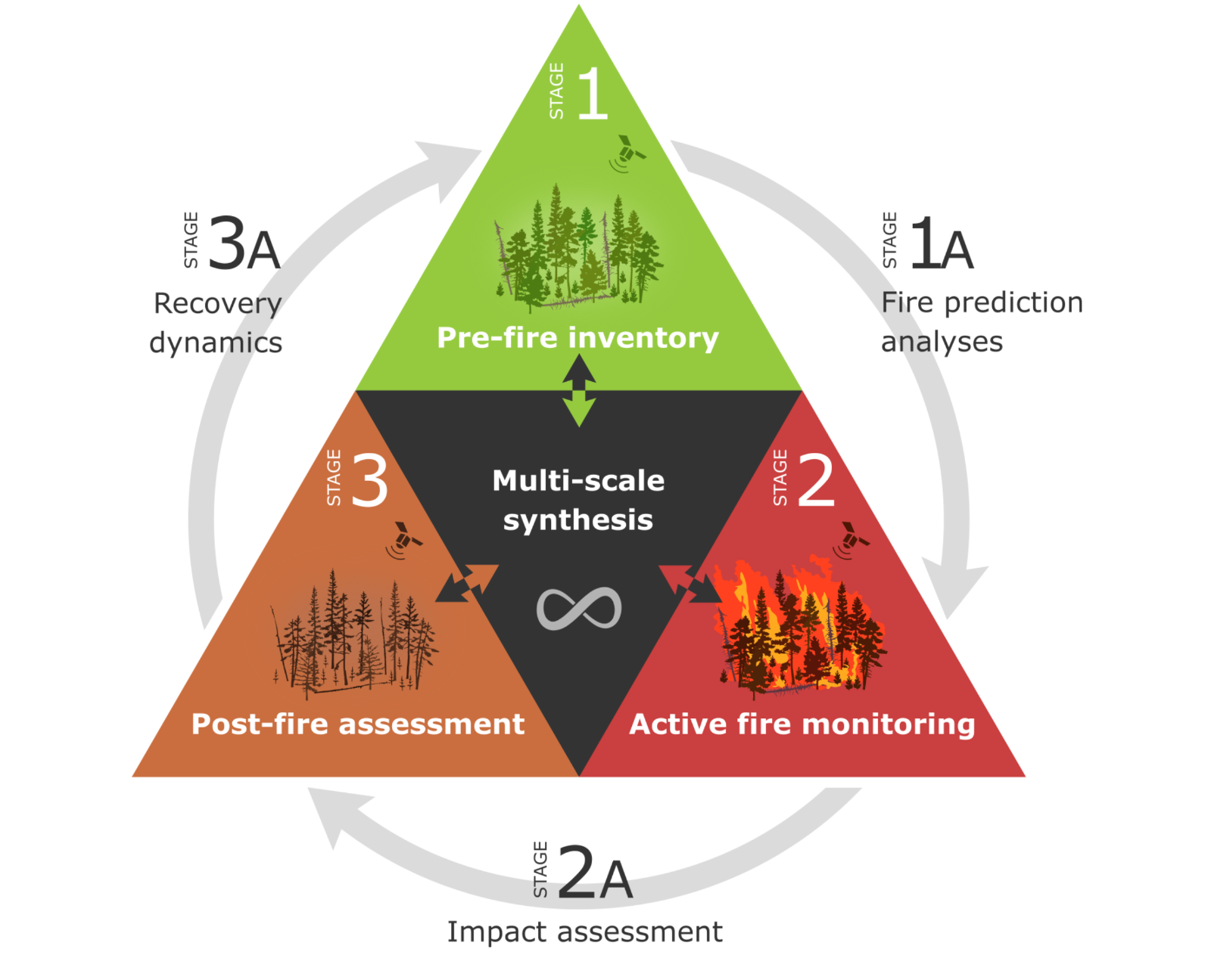
"Towards a whole-system framework for wildfire monitoring using Earth observations." 🔥🌲🛰️
Check out our brand new #OpenAccess paper in Global Change Biology! My first with
#NRCan #GLFC.
In this paper, we present a conceptual framework for holistic #wildfire monitoring. We review the stages and #EarthObservation information needs and apply this to 4 #fire case studies.
When working in #firemonitoring, it's important to be clear about your objectives... this paper can help! #EOChat
#openaccess #nrcan #GLFC #wildfire #earthobservation #fire #firemonitoring #eochat
Maxim F · @mxf
37 followers · 28 posts · Server fosstodon.org
Assessing and Mitigating Ice-Jam #Flood Hazards and Risks: A European Perspective
https://www.mdpi.com/2073-4441/15/1/76
It would certainly be interesting to organize a similar workshop in #Canada, with a lot of work on-going in #icejam #modeling, both from a #floodhazard and #floodrisk perspective
#hydrology #hydraulic #floodmapping #winter #ice #river #risk #FHIMP #NRCan #ECCC
#flood #canada #icejam #modeling #floodhazard #floodrisk #hydrology #hydraulic #floodmapping #winter #ice #river #risk #fhimp #nrcan #eccc
Richard · @richardvenusfo
197 followers · 1219 posts · Server fosstodon.orgSomething I have used a lot this year and is excellent https://github.com/RichardScottOZ/geoscience_language_models - a fork of the #NRCAN original with a few updates and also doing some things in #Portuguese #Brazil - it is really well done and has pretty good #OpenSource models available too - with a Canada focus. I would have put a million documents through it roughly. #NLP #DataScience #DataEngineering #Python #Geoscience #gloVe #geology #wordembeddings #MineralExploration #Copper #Nickel
#nrcan #portuguese #brazil #opensource #nlp #datascience #dataengineering #python #geoscience #glove #geology #wordembeddings #mineralexploration #copper #nickel

Denyse Dawe · @dee_dawe
67 followers · 83 posts · Server vis.socialNatural Resources Canada (#NRCan) is hiring a Fire Weather Scientist!
The crew at the Northern Forestry Centre are FANTASTIC to work with. Take a gander and share:
https://emploisfp-psjobs.cfp-psc.gc.ca/psrs-srfp/applicant/page1800?toggleLanguage=en&poster=1877866
#ScienceMastodon #academicmastodon #science #wildfire #nrcan
Maxim F · @mxf
37 followers · 28 posts · Server fosstodon.orgThe new Historical #Flood Events data layer (HFE) is now LIVE in #Canada! And updated continuously using media records.
"With over 1400 flood events documented in over 7000 locations, the #NRCan Historical Flood Events data layer provides an accessible way to view the who, what, when, and where of historical flood events in Canada."
#floodriskmanagement #floodmapping #climatechange #resilience
#flood #canada #nrcan #FloodriskManagement #floodmapping #climatechange #resilience
Maxim F · @mxf
37 followers · 28 posts · Server fosstodon.org#introduction
Good morning everyone!
Engineer specialized in #hydrology and #hydraulics, #flood mapping and #geospatial data
🌍✈️ Formerly at #Cowater, worked across the globe for about 10 years on #waterinfrastructure, #water resources management and #environment in a developing context
💧🛰️ Now working closer to home, focused on #floodriskmanagement and #floodmapping in #Canada with #NRCan #gischat #eochat
When not working: #photography, #F1 and spending time with the little family!
#introduction #hydrology #hydraulics #flood #geospatial #Cowater #waterinfrastructure #water #environment #FloodriskManagement #floodmapping #canada #nrcan #gischat #eochat #photography #f1
Morgan Crowley · @morganahcrowley
601 followers · 113 posts · Server fosstodon.org
Hey #eochat #gischat folks- I’m new here! Here’s an #introduction:
➡️ I’m a forest fire research #scientist with #NRCan #CanadianForestService on the core science team of the #WildFireSat mission. I use satellite imagery like #Landsat #modis #Sentinel2 to map fires.
➡️ I am co-director and a founding member of #LadiesofLandsat and a co-host on the new season of #SceneFromAbove podcast.
➡️ I am a #GoogleDeveloperExpert in #EarthEngine. I am a co-editor of www.eefabook.org
Thanks for connecting!
#eochat #gischat #introduction #scientist #nrcan #CanadianForestService #WildFireSat #landsat #modis #sentinel2 #LadiesofLandsat #scenefromabove #GoogleDeveloperExpert #EarthEngine