Scott Miller 🇺🇦 🇺🇸 · @scottmiller42
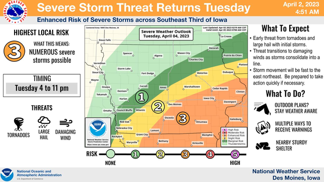
61 followers · 163 posts · Server mstdn.social"There is an increasing threat for severe storms on Tuesday across portions of central and eastern Iowa. The highest threat exists over about the southeast third of the state where a few tornadoes, damaging winds and large hail are all possible late Tuesday afternoon into the evening. The storms will likely be moving fast as well. Be weather aware on Tuesday and be prepared to seek shelter quickly if necessary!"
#nwsdesmoines #iowaweather #iawx
Scott Miller 🇺🇦 🇺🇸 · @scottmiller42
51 followers · 87 posts · Server mstdn-social.social.shrimpcam.pwRT @NWSDesMoines@Twitter
Winter storm to impact the area Wednesday through early Thursday. Less certainty for snow amounts over parts of central Iowa due to precipitation type and exact storm track potential adjustments.
#nwsdesmoines #iowaweather #iawx
Scott Miller 🇺🇦 🇺🇸 · @scottmiller42
46 followers · 69 posts · Server mstdn.socialRT @NWSDesMoines@Twitter
Winter storm to impact the area Wednesday through early Thursday. Less certainty for snow amounts over parts of central Iowa due to precipitation type and exact storm track potential adjustments.
#nwsdesmoines #iowaweather #iawx
Scott Miller 🇺🇦 🇺🇸 · @scottmiller42
31 followers · 34 posts · Server mstdn.socialRT #NWSDesMoines @ Twitter
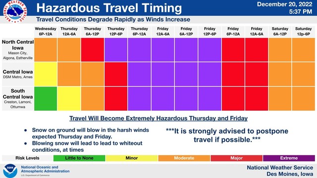
The expected snow and strong winds will make travel difficult across much of central Iowa early Thursday morning through Friday, especially in rural areas. Be prepared for poor travel conditions with blowing/drifting snow producing near whiteout/blizzard conditions. #iawx #IowaWeather
See picture ALT text for additional details.
#iowaweather #iawx #nwsdesmoines
Scott Miller 🇺🇦 🇺🇸 · @scottmiller42
31 followers · 34 posts · Server mstdn.socialRT #NWSDesMoines @ Twitter
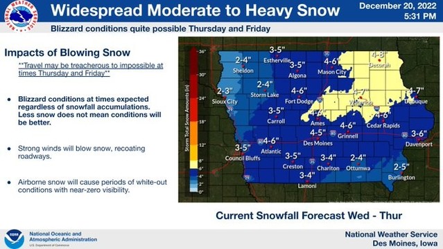
Moderate to heavy snow is anticipated with this storm, starting north and west Wednesday and becoming widespread Wednesday night into Thursday, ending late in the day. 40 to 50 mph gusts will create significant blowing and drifting snow with blizzard conditions possible. #iawx #IowaWeather
See picture ALT text for additional details.
#iowaweather #iawx #nwsdesmoines
Scott Miller 🇺🇦 🇺🇸 · @scottmiller42
31 followers · 34 posts · Server mstdn.socialRT #NWSDesMoines @ Twitter
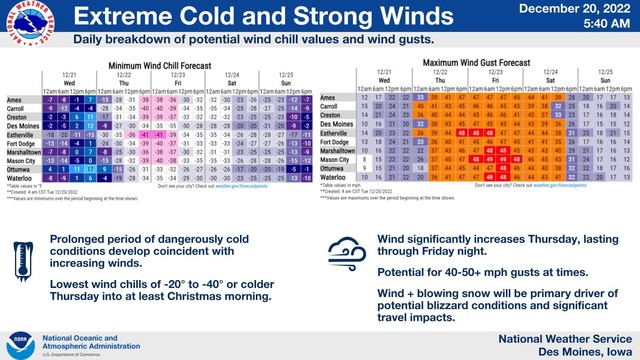
⚠️ Main points with impending winter storm Wed-Fri night
❄️ Moderate to heavy snow late Wed into Thu
🌬️ Strong, gusty winds likely producing blizzard conditions Thu-Fri night
🥶 These winds will also produce extremely cold wind chills -20 to -40° Thu into Sat morning.
See picture ALT text for additional details.
#iowaweather #iawx #nwsdesmoines


