
Queer In The Country · @QueerInTheCountry
94 followers · 245 posts · Server mas.toI wish it was raining men instead of snowing ash in Edmonton.
I just saw a video where it's snowing ash from the #BCWildfire and #nwtfire
It'd be nice if we started taking meaningful action on #climatechange
#lgbtq
#lgbtq #climatechange #nwtfire #bcwildfire

Joseph Elfelt · @mappingsupport
478 followers · 402 posts · Server m.ai6yr.org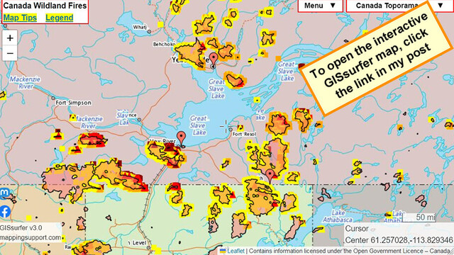
In Canada’s #NorthwestTerritories the 3 largest towns are #Yellowknife , #HayRiver and #FortSmith . All have been order to evacuate due to wildland fires. When this map opens there is a marker at each of these towns.
Map also shows MODIS and VIIRS satellite heat detections. Dark red = detection within prior 6 hours.
Zoom in for detail.
See 2 links upper left corner. #ClimateEmergency #NWT #NWTfire #NWTwildfires
Open #GISsurfer map:
https://mappingsupport.com/p2/gissurfer.php?center=61.258849,-113.833294&zoom=7&basemap=Canada_Toporama&overlay=VIIRS_7_day,MODIS_7_day,CA_fire_perimeter&txtfile=https://mappingsupport.com/p2/special_maps/disaster/Canada_wildland_fire.txt||62.460545,-114.371796||60.823678,-115.787659||60.009371,-111.878929
#northwestterritories #yellowknife #hayriver #fortsmith #climateemergency #nwt #nwtfire #nwtwildfires #gissurfer
Joseph Elfelt · @mappingsupport
464 followers · 383 posts · Server m.ai6yr.org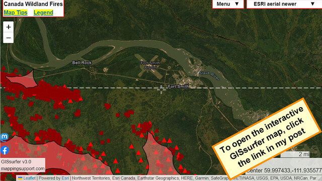
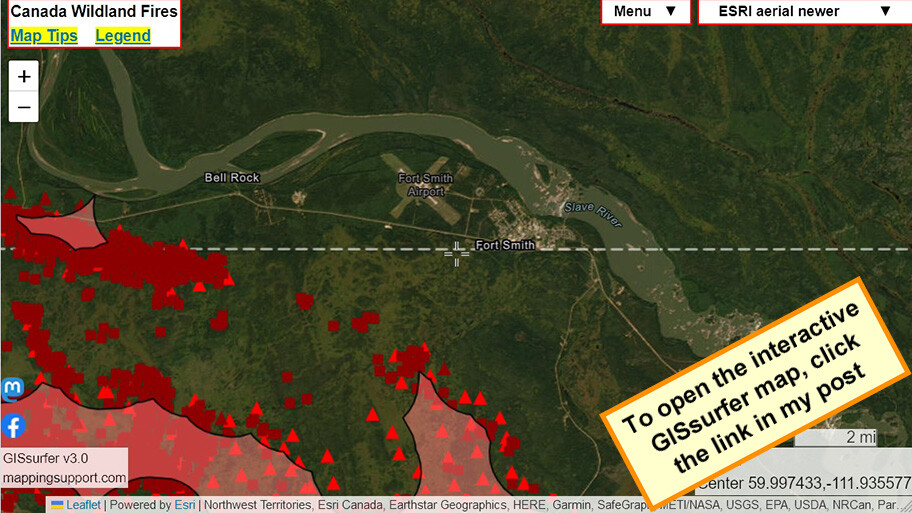
Interactive #GIS map showing MODIS and VIIRS satellite *heat* detections for wildfire near #FortSmith Northwest Territories, Canada. The town has been ordered to evacuate,
#NWT #NorthwestTerritories #NWTfire #CAfire
Open #GISsurfer map:
https://mappingsupport.com/p2/gissurfer.php?center=59.997433,-111.935577&zoom=11&basemap=ESRI_aerial_newer&overlay=MODIS_7_day,VIIRS_7_day,CA_fire_perimeter&txtfile=https://mappingsupport.com/p2/special_maps/disaster/Canada_wildland_fire.txt
#gis #fortsmith #nwt #northwestterritories #nwtfire #cafire #gissurfer
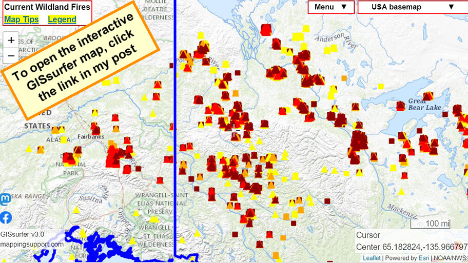
Joseph Elfelt · @mappingsupport
439 followers · 335 posts · Server m.ai6yr.org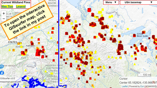
Interactive #GIS map showing MODIS and VIIRS *heat* detections. Dark red is a detection within prior 6 hours.
This data only shows approximate locations, is not real time and sometimes is ‘false positive’. To learn more click “Map tips” upper left corner and read about MODIS and VIIRS.
#AKfire #AKwx #CanadaFire #NWTfire #Geospatial #Maps #Mapping #Leaflet #ArcGIS #WebMap
Open #GISsurfer map:
https://mappingsupport.com/p2/gissurfer.php?center=65.182824,-135.966797&zoom=5&basemap=USA_basemap&overlay=VIIRS_7_day,MODIS_7_day,State_boundary&data=https://mappingsupport.com/p2/special_maps/disaster/USA_wildland_fire.txt
#gis #akfire #akwx #canadafire #nwtfire #geospatial #maps #mapping #leaflet #arcgis #webmap #gissurfer