bengt 𓀙𓂋𓋴 · @bengt
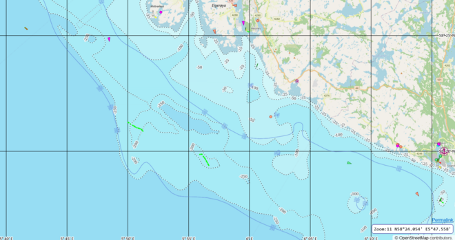
116 followers · 108 posts · Server mastodon.bv.linksjugend-solid.dedie #openseamap-funktionen "meeresprofil" und "tiefenlinien" sind ganz nett, aber es ist etwas merkwürdig, wenn sich beide inhaltlich widersprechen (die 100m-tiefenlinie ist tlw. deutlich entfernt von der 100m-meeresprofillinie).
kartenlink: https://map.openseamap.org/?zoom=11.5&lon=5.90305&lat=58.36328&layers=TFTFFTTFFTFFTFFFFFFFTT
Nicolas Pettiaux · @npettiaux
38 followers · 121 posts · Server tchafia.be#fedi22 #photography #video #music #flute #piano #mozart #schubert #MichelLysight #gnulinux #debian #oer #rel #math #physics #freeCulture #CreativeCommons #ccbysa #copyleft #professor #education #wikipedia #ecology #sailing #openseamap #openstreetmap #coursLibresDotOrg #educode #freesoftware #cycling #velo #bruxelles #Belgium #ulbruxelles #GarciaYachts #sharing #transmission #logicielLibre #openEducation #framasoft
#fedi22 #photography #video #music #flute #piano #mozart #schubert #MichelLysight #gnulinux #debian #oer #rel #math #physics #freeculture #creativecommons #ccbysa #copyleft #professor #education #wikipedia #ecology #sailing #openseamap #openstreetmap #coursLibresDotOrg #educode #freesoftware #cycling #velo #bruxelles #belgium #ulbruxelles #GarciaYachts #sharing #transmission #logiciellibre #openeducation #framasoft
xriss · @xriss
198 followers · 3980 posts · Server troet.cafeFür die Grobnavigation nutze ich den Schiffsmodus samt #openseamap in #osmand.
Gibt es eine Möglickeit die #AIS Daten via #shipfinder in @openstreetmap darzustellen?
#openseamap #osmand #AIS #shipfinder
· @linkdrop
45 followers · 1816 posts · Server botsin.spaceOpenSeaMap: Startseite https://openseamap.org #openstreetmap #openseamap #sea #map
#openstreetmap #openseamap #sea #map
· @ThierryStoehr
364 followers · 1644 posts · Server framapiaf.orgVous connaissez #OpenStreetMap ?
Mais connaissez-vous #OpenSeaMap ?
Oui, c'est la même approche mais avec des «informations nautiques et touristiques susceptibles d'intérésser les plaisanciers. »
Donc non seulement le #format du nom est similaire, mais l'approche aussi !
Bonnes utilisation et exploration et même participation !
http://openseamap.org/
Source : @framaka ici et le même sur Twitter.
#openstreetmap #openseamap #format
celinem · @celinem
148 followers · 2153 posts · Server framapiaf.orgOpenSeaMap la cartographie nautique libre, petite sœur du terre à terre OpenStreetMap ;)
On peut même y voir le trafic maritime en temps réel !
#openseamap #openmap
https://openseamap.org/index.php?id=31&L=3
Penbeuz · @penbeuz
91 followers · 659 posts · Server framapiaf.orgzavez vu que la cartographie pour suivre la solitaire c'est #openstreetmap + #opentopomap avec les données #openseamap, c'est classe et il y a un peu de mon boulot 😃 https://www.lasolitaire-urgo.com/cartographie
#openstreetmap #opentopomap #openseamap
