
Krafty :arcolinux: :neovim: · @tkk13909
89 followers · 3062 posts · Server fosstodon.org@Phate6660 #CompleteStreet is an app that let's you edit #OpenStreetMaps by doing "quests". You can only do quests within a certain area around you (which is why I will NOT be sharing screenshots) and you get little awards for doing different things!
#completestreet #openstreetmaps

Andyt · @andyt_at
2 followers · 32 posts · Server social.vivaldi.netUmstieg auf Leaflet für OpenStreetMap
Bereits seit Anbeginn des Blogs gab es bei einem Reisebericht mit dem Roadster eine entsprechende Darstellung der gefahrene Strecke, welche mit einem GPS Datenlogger aufgezeichnet wurde.
Begonnen hat dies mit einem Screenshot aus dem jeweils genutzten Programm
https://blackseals.net/blog/2023/09/07/umstieg-auf-leaflet-fuer-openstreetmap/
#Allgemein #Android #GPSDatenlogger #GPSPhotoTagger #LDLog #Leaflet #OpenStreetMaps #Roadster #WordPress
#allgemein #android #gpsdatenlogger #gpsphototagger #ldlog #leaflet #openstreetmaps #roadster #wordpress

Fil · @fil
34 followers · 206 posts · Server hachyderm.ioFinally made panning work. Had to juggle so many coordinate systems
#RustLang #OpenStreetMaps
abmurrow🪤🦆 · @abmurrow
2 followers · 49 posts · Server fosstodon.orgJust discovered the #streetcomplete app for #openstreetmaps today and what a treat! It's an app on F-Droid (and probably elsewhere) that lets you make contributions and edits to missing data on Open Street Maps.
This app is a super simple way to contribute to OSM and #FOSS right from your home.
#streetcomplete #openstreetmaps #foss
Ruth Mottram · @Ruth_Mottram
7450 followers · 10938 posts · Server fediscience.orgI'm no longer sure who it was on here, but some one recommended organic maps app as a privacy friendly alternative to Google maps, built on #openstreetmaps I've been trying it out the last 3 days and it is really brilliant. So 🙏 to whoever it was.
#degooglify #degoogle #organicMaps #privacy #openstreetmaps

Andy McKay · @KorimakoEcology
1066 followers · 2177 posts · Server ecoevo.social@smallcircles Are you able to upload your own base map layers? #OpenStreetMaps is fine for urban navigation but not particularly useful in the wilderness.

Neurobändiger · @Autistenhausen
65 followers · 516 posts · Server troet.cafe
:ablobcatattentionreverse: :blobcataco: :ablobcool: #StreetComplete #OpenStreetMaps #Gamification #ProudOfMyself
#proudofmyself #gamification #openstreetmaps #streetcomplete
Alexandre B A Villares · @villares
19 followers · 27 posts · Server pynews.com.br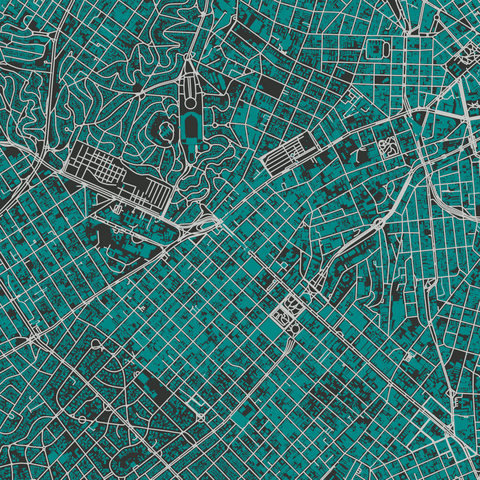
#Python #matplotlib explorando dados © contribuidores do #OpenStreetMaps
#python #matplotlib #openstreetmaps
Friede Freude 《🕊🙃🥞》🌞⚡️ · @FriedeFreude
30 followers · 1047 posts · Server social.tchncs.de@sr388
Ich benutze nur Offline-Karten auf Basis von #openstreetmaps .
Die besten Karten zum Radfahren und Wandern kommen von Openandromaps

MaptimeBogota · @MaptimeBogota
107 followers · 84 posts · Server en.osm.town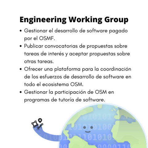
Engineering Working Group
¿Qué hace este grupo?
* Gestionar el desarrollo de software pagado por el OSMF.
* Publicar convocatorias de propuestas sobre tareas de interés y aceptar propuestas sobre otras tareas.
* Ofrecer una plataforma para la coordinación de los esfuerzos de desarrollo de software en todo el ecosistema OSM.
* Gestionar la participación de OSM en programas de tutoría de software.
https://wiki.osmfoundation.org/wiki/Engineering_Working_Group

Enrico "meldrian" Michaelis · @meldrian
301 followers · 818 posts · Server social.tchncs.deMein Tag geht langsam in die Schonphase über. Start war um 6 Uhr.
Der Plan? Raus vor die Tür, rumlaufen, Infos eintragen, kartieren oder Bilder für später am PC machen. Hat auch geklappt.
Ab 9 Uhr wurde es langsam aber sicher warm weil die Sonne sich immer weiter durch die Wolken mogeln konnte. Also noch schnell Brötchen gekascht und ab nach Hause.
Jetzt? Frühstück.
Danach?
"Am 7ten Tag soll man entspannen"
-- "Eins Zwo" mit "schon unterwegs"
#openstreetmaps #streetcomplete #EveryDoor

ferrie = differentieel :mfrl: · @differentieel
151 followers · 2892 posts · Server mastodon.frl
@jeroensmeets heb je wel eens van #OpenStreetMaps gehoord, Jeroen?
dat is een #OpenSource map die je privéleven NIET in kaart brengt om je advertenties voor te schotelen - misschien eens naar kijken en jezelf beschermen tegen diefstal?

anipatok · @anipatok
3 followers · 27 posts · Server musicians.today@RL_Dane
I am trying to stay away from g**gle stuff as good as I can. #openstreetmaps is my go to for maps, or offline maps based on openstreetmaps.👍

Andrew Wedlake · @adventure_tense
52 followers · 340 posts · Server mapstodon.spaceI celebrate Open Street Maps by using Organic Maps almost every day. The more we put into it, the more we get out.
#openstreetmaps #organicMaps #opensource

Ken Oh · @kenoh
18 followers · 239 posts · Server mstdn.socialHappy 19th Birthday to #openstreetmaps
https://blog.openstreetmap.org/2023/08/09/happy-birthday-openstreetmap-2/

Dick Smiths Fair Go Supporters · @dsfgs
176 followers · 14032 posts · Server activism.openworlds.info@Mary625 @not2b @ned @funcrunch @jenniferplusplus @Dasy2k1 @dragonfrog
What we propose, at times, can prevent access to certain websites that use services that violate people and violate antitrust.
A physical letter can work wonders. Also we have taken to suggesting that people use cheques if there bank starts to do bad things. For maps there is #OpenStreetMaps.
Being big is not necessarily the problem — being unethical, #technoFeudal fascists thatare societal cancer is the issue.

Daniel van DAN :mfrl: · @dan
13 followers · 40 posts · Server mastodon.frl
Nieuw blogpost: "Netbeheerders hebben moeite om de energietransitie bij te houden" Leestijd: 2 minuten En dat weten ze al 20 jaar dat dit eraan zat te komen! De Volkskrant bericht op 3 augustus 2023 over de opstoppingen in het Nederlandse […]
#Dodewaard #energienet #Enexis #hoogspanningsnetwerk #Liander #OpenStreetMaps #Volkskrant
Lees verder: https://dan.frl/2023/08/netbeheerders/
#dodewaard #energienet #enexis #hoogspanningsnetwerk #liander #openstreetmaps #volkskrant

Morgan Fletcher :vbike: · @morgan
494 followers · 2429 posts · Server sfba.social
The early 20th century meant the #development of #Oakland for #cars and for #HomeBuilding. The #bicycle was mostly forgotten, except as a toy or a piece of sports equipment, and #neighborhoods were laid out and #developed privately, by for-profit corporations rather than a civic body meant to benefit the citizens of Oakland. #PublicTransit was deprecated, except as a vehicle for #RealEstate sales. #AutoRow, on Broadway, and the car plants were churning out cars, and #debt to the people of Oakland, and the #newspaper was a marketing organ for these industries... This is all described really well in #MitchellSchwarzer 's book #HellaTown, which I recommend. I like old #maps, knowing how #roads came to be, and I've always been curious about the term "Little Skyline," which shows up in articles from this time. This article explains the route, and tells the story...
https://fastestslowguy.blogspot.com/2023/07/new-roads-open-routes-for-autoists.html
#development #oakland #cars #homebuilding #bicycle #neighborhoods #developed #publictransit #realestate #autorow #Debt #newspaper #mitchellschwarzer #hellatown #maps #roads #georeference #openstreetmaps #history #Piedmont

Conor C. :minecraft_diamond: · @wemic
29 followers · 436 posts · Server social.linux.pizzaWent to add #Montenegro bus routes on #GoogleMaps and promptly found out they don't allow regular users to add such info.
Sent an email to the Mayor offering help. But being the stubborn engineer that I am, I couldn't sit around and wait.
Remembered #OpenStreetMaps exists! And a lot of work had already been done! Furthermore, I found that the official website for the capital, in its "Map" section, uses the OSM API, not GMaps!
God I love open, community-driven projects. ❤️
#montenegro #googlemaps #openstreetmaps

Brennan Stehling · @brennansv
124 followers · 1796 posts · Server sfba.social@dougburns Since you have already done most of the work, these features could also be great for a hiking app which also could use #OpenStreetMaps for more detailed hiking paths and points of interest. I don't golf, but I would use a hiking app on my watch.