
AllQuakes - EMSC · @emsc
888 followers · 54865 posts · Server masto.ai#Earthquake (#sismo) M2.7 strikes 10 km SW of #Oroville (#California) 2 min ago. More info: http://m.emsc.eu/?id=1536562
#earthquake #sismo #oroville #california

Joseph Elfelt · @mappingsupport
417 followers · 307 posts · Server m.ai6yr.org
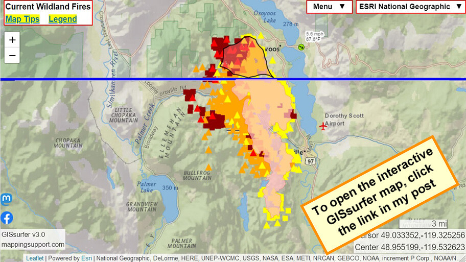
July 31 morning. Interactive #GIS map shows MODIS and VIIRS satellite *heat* detection for #EagleBluffFire near #Oroville WA and #Osoyoos BC.
Apparently no infrared flight last night.
Pink area on USA side is clickable and at time of my post shows 9,743 acres as of Saturday evening.
#WAfire #WAwx #BCfire #wildfire #Geospatial #Maps #Mapping #Leaflet #ArcGIS #WebMap
Open #GISsurfer map: https://bit.ly/43OfN8X
#gis #eagleblufffire #oroville #osoyoos #wafire #wawx #bcfire #Wildfire #geospatial #maps #mapping #leaflet #arcgis #webmap #gissurfer
Joseph Elfelt · @mappingsupport
417 followers · 307 posts · Server m.ai6yr.org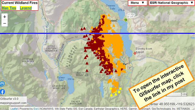
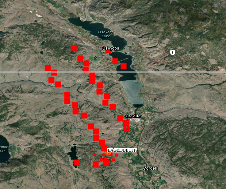
July 30 evening. Interactive #GIS map shows MODIS and VIIRS satellite *heat* detection for #EagleBluffFire near #Oroville WA and #Osoyoos BC.
If there is an infrared flight tonight then I will post a map with that data early tomorrow.
#WAfire #WAwx #BCfire #wildfire #Geospatial #Maps #Mapping #Leaflet #ArcGIS #WebMap
Open #GISsurfer map:
https://mappingsupport.com/p2/gissurfer.php?center=48.955199,-119.532623&zoom=11&basemap=ESRI_National_Geographic&overlay=VIIRS_7_day,MODIS_7_day,State_boundary,Wind_temperature_and_more...&data=https://mappingsupport.com/p2/special_maps/disaster/USA_wildland_fire.txt
#gis #eagleblufffire #oroville #osoyoos #wafire #wawx #bcfire #Wildfire #geospatial #maps #mapping #leaflet #arcgis #webmap #gissurfer

MiBaWi - Michael Barthel · @MiBaWi
350 followers · 1049 posts · Server m.ai6yr.org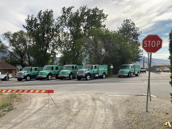
An USDA strike team from #California was seen this morning at the #Oroville - #Osoyoss border crossing. They will be used in rotation service in different wildfire areas of #BritishColumbia
#california #oroville #osoyoss #BritishColumbia
Joseph Elfelt · @mappingsupport
413 followers · 301 posts · Server m.ai6yr.org
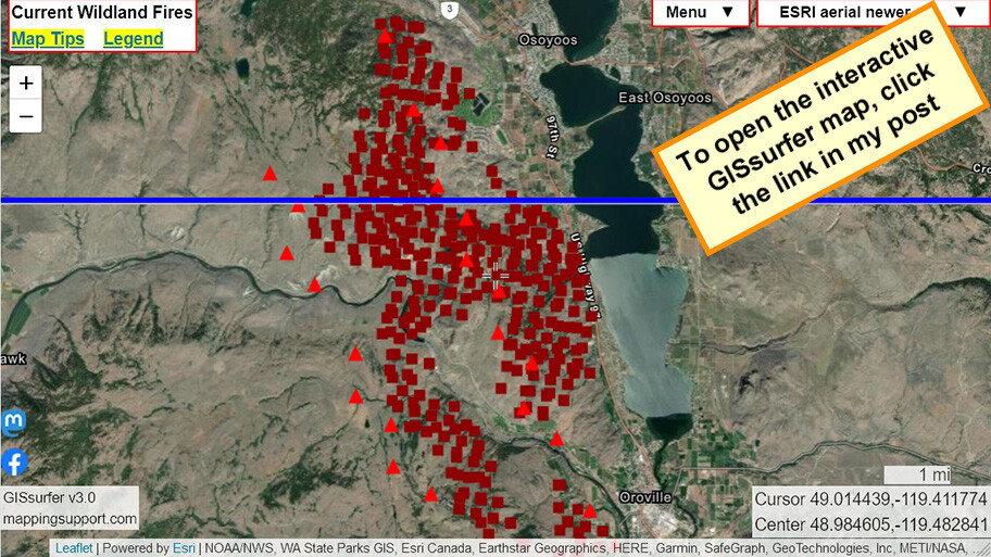
July 30 morning. Interactive #GIS map shows MODIS and VIIRS satellite *heat* detection for #EagleBluffFire near #Oroville WA and #Osoyoos BC.
Detection data is not real time, locations only approximate and sometimes ‘false positive’. To learn more, click “Map tips” in upper left corner and read about MODIS/VIIRS.
#WAfire #WAwx #BCfire #wildfire #Geospatial #Maps #Mapping #Leaflet #ArcGIS #WebMap
Open #GISsurfer map:
https://mappingsupport.com/p2/gissurfer.php?center=48.984605,-119.482841&zoom=12&basemap=ESRI_aerial_newer&overlay=VIIRS_7_day,MODIS_7_day,State_boundary&data=https://mappingsupport.com/p2/special_maps/disaster/USA_wildland_fire.txt
#gis #eagleblufffire #oroville #osoyoos #wafire #wawx #bcfire #Wildfire #geospatial #maps #mapping #leaflet #arcgis #webmap #gissurfer
MiBaWi - Michael Barthel · @MiBaWi
350 followers · 1049 posts · Server m.ai6yr.org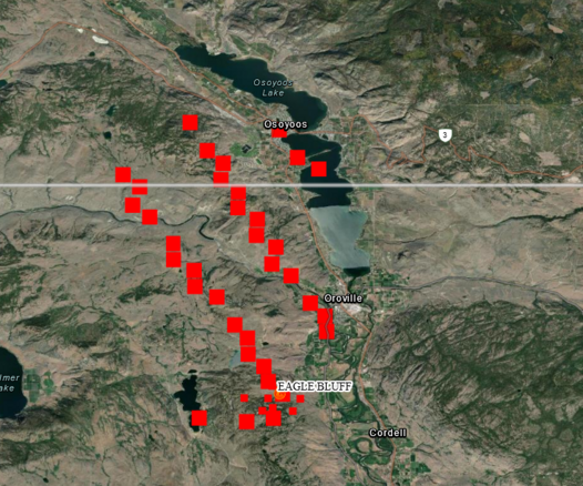
#EagleBluffFire #Oroville / #Osoyoos
FIRMS US/CANADA Wildfire Map > https://firms.modaps.eosdis.nasa.gov/usfs/map/#d:24hrs;@-119.4,49.0,12z
#eagleblufffire #oroville #osoyoos
MiBaWi - Michael Barthel · @MiBaWi
351 followers · 1045 posts · Server m.ai6yr.org#EagleBluffFire #Oroville #OkanoganCounty #Washington - Evacuation Center / Shelter
Red Cross Shelter:
Oroville High School, 1016 Ironwood St, Oroville, WA 98844, Call 206-450-8564
Animal Shelter:
Tonasket Rodeo Grounds, 12 Rodeo Rd, Tonasket, WA 98855
#eagleblufffire #oroville #okanogancounty #washington

BC Info Bot · @bcinfo
541 followers · 39256 posts · Server mastodon.roitsystems.caGlobal News BC: Evacuation alert issued for Osoyoos after U.S. wildfire crosses border https://globalnews.ca/news/9865849/bc-evacuation-alert-osoyoos-wildfire-crosses-border/ #globalnews #britishcolumbia #news #RegionalDistrictOkanagan-Similkameen #LonePineCreekwildfire #wildfirecrossesborder #EagleBluffWildfire #EvacuationAlerts #southerninterior #southokanagan #BCwildfires #BCInterior #Oroville #osoyoos #Canada #rdos
#globalnews #BritishColumbia #news #regionaldistrictokanagan #lonepinecreekwildfire #wildfirecrossesborder #eaglebluffwildfire #evacuationalerts #southerninterior #southokanagan #BCwildfires #BCInterior #oroville #osoyoos #Canada #rdos
MiBaWi - Michael Barthel · @MiBaWi
350 followers · 1042 posts · Server m.ai6yr.org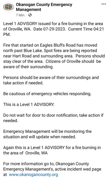
#EagleBluffFire > 239 Eagles Bluff Rd, #Oroville, #OkanoganCounty / #Washington
Level 1 > If you feel unsafe, do not wait for evacuation orders .
Evacuation updates
https://www.facebook.com/Okanogan.County.Emergency.Management
Cam
https://www.alertwildfire.org/region/oregon/?camera=Axis-Aeneas
Watch Duty
https://app.watchduty.org/i/8613#allow-back
#eagleblufffire #oroville #okanogancounty #washington
MiBaWi - Michael Barthel · @MiBaWi
339 followers · 989 posts · Server m.ai6yr.org
#Oroville, #ButteCounty / #California > The final touches are being made to a new #CalFire facility, the Table Mountain Fire Center , in preparation for crews to move in early to mid-August.
#california #oroville #buttecounty #calfire

AI6YR · @ai6yr
4092 followers · 24107 posts · Server m.ai6yr.org

Caltrans District 3 (bot) · @CaltransDist3_bot
123 followers · 33 posts · Server m.ai6yr.org
We're making great progress on our #CleanCA project in #Oroville! Slope paving under SR-70 at Oro Dam has a river rock veneer, a shoutout to the Feather River just a "stone's throw" away! The project is scheduled to be completed in late July/early August. @CAgovernor @CaltransHQ
Caltrans District 3 (bot) · @CaltransDist3_bot
121 followers · 29 posts · Server m.ai6yr.org
COMING SOON...AMAZING PUBLIC ART! Part of our #CleanCA project in #Oroville along SR-70 at Oro Dam Blvd. and Montgomery Street! Thanks @RainforestArtP and the countless local kids who helped create these beautiful works for all to enjoy! @CountyofButte @CaltransHQ @CAgovernor
Caltrans District 3 (bot) · @CaltransDist3_bot
118 followers · 22 posts · Server m.ai6yr.org
Work continues on our #CleanCA project in #Oroville! Here are some photos of landscaping efforts at SR-70 and Montgomery St. Our team and Viking Construction will work through the end of July, so please be cautious when traveling in the area! @CAgovernor @CaltransHQ @CHP_Oroville

Jason Stiff · @JasonStiff
342 followers · 633 posts · Server sfba.social
I had a fun time talking to all the 5th graders at Ophir ES on a rainy, windy Tuesday! I'm now back at work, and I'll have your stormy 7-day weather forecast at 4, 5, 6, 10 & 11pm!
#California #Chico #Redding #Oroville #NorCal #school #rain #wind #snow #Tuesday #March #spring #weather #wx #cawx #caweather #weatherMastodon #wxmastodon #climate
#california #chico #redding #oroville #norcal #school #rain #wind #snow #tuesday #March #spring #weather #wx #cawx #caweather #weatherMastodon #wxmastodon #climate

nu.nl RSS · @nunl
337 followers · 5040 posts · Server mastodon.nl
Video | Enorme hoeveelheid water stroomt door Amerikaanse stuwdam
#californie #oroville #sluizen
Jason Stiff · @JasonStiff
330 followers · 591 posts · Server sfba.socialI visited Shasta Lake on Saturday... so beautiful and still filling with water! Water isn't being released there like at Lake Oroville, which has now FALLEN a foot to the same level it was on Thursday!
#California #Chico #Redding #Oroville #ShastaLake #LakeOroville #beautiful #water #lake #lakes #Saturday #Sunday #weekend #weather #wx #cawx #caweather
#california #chico #redding #oroville #shastalake #lakeoroville #beautiful #water #lake #lakes #saturday #sunday #weekend #weather #wx #cawx #caweather

Geewhizpat · @Geewhizpat
737 followers · 2112 posts · Server newsie.social
#Oroville #Dam operations update: reservoir levels are 159K acre-ft higher than allowed for standard flood protection (flood pool= top 750K acre-ft). 25K cfs released thru spillway now, increasing to 35K cfs today AM. #cawx #FloodLevels
#oroville #dam #cawx #floodlevels
Geewhizpat · @Geewhizpat
737 followers · 2112 posts · Server newsie.social
Geewhizpat · @Geewhizpat
737 followers · 2111 posts · Server newsie.social
#Oroville Dam Spillway releases increasing to 35K cfs. Inflow now at 40kcfs. Can't keep up. Via CHP Oroville: Due to increased outflow from the Oroville Dam Spillway and safety concerns, Oro Dam Blvd. East will be closed to traffic from Canyon Dr. to Glen Dr. There will be manned hard closures at both locations. Please seek alternate routes. #cawx #Floodlevels #Dams
#oroville #cawx #floodlevels #dams