𝑪𝒐𝒓𝒆𝒚 𝑺𝒏𝒊𝒑𝒆𝒔 🌱 · @coreysnipes
331 followers · 893 posts · Server fosstodon.orgA very nice experiment examining different overlap values for drone mapping flights, ranging from 95% to 35%.
https://www.youtube.com/watch?v=9WMTc3HH4uM
#drone #drones #dronemapping #photogrammetry #opendronemap #metashape #dronedeploy #pix4d
#drone #drones #dronemapping #photogrammetry #opendronemap #metashape #dronedeploy #pix4d
Ingmar Nitze · @i_nitze
108 followers · 102 posts · Server mapstodon.spaceIt never gets old.🤩 🤩 🤩
VHR #SfM #DSM from aerial imagery. 10 cm spatial resolution.
Imuruk #lava field in #Alaska.
Processed with #pix4d and #whiteboxtools. Visualized in #QGIS.
#geo #permafrost #arctic
Aerial imagery was captured in July 2021.
#sfm #dsm #lava #alaska #pix4d #whiteboxtools #qgis #geo #permafrost #arctic
Marc-Aurèle Brothier · @marcaurele
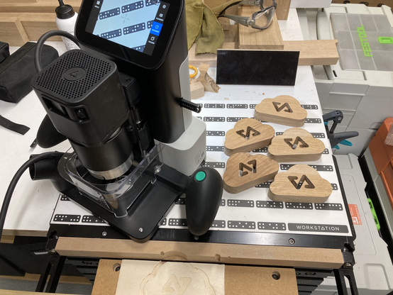
21 followers · 32 posts · Server mastodon.socialDoing a few items of my #pix4d #cloud logo. I 😍 so much my #origin from #shapertools
#pix4d #cloud #origin #shapertools
Ingmar Nitze · @i_nitze
73 followers · 52 posts · Server mapstodon.spaceBeautiful #DSM from #S-f-M of aerial imagery in western #Alaska. Processed with #Pix4d and #whiteboxtools.
Kougarok river on the Seward Peninsula south of Last Bridge (North of Nome).
#permafrost polygons
#pingo
beach ridges
#river
drained lake basins
#dsm #s #alaska #pix4d #whiteboxtools #permafrost #pingo #river
Geo Arnaud · @arnaud_vandecasteele
26 followers · 34 posts · Server mapstodon.spaceLa version 3.0 d'#OpenDroneMap est disponible https://opendronemap.org/2022/11/get-ready-odm-3-0-is-here/. Cette version apporte des améliorations conséquentes aux rendus générés.
Pour comparer les évolutions de rendus entre les versions (et même d'autres logiciels comme #Pix4D) : https://opendronemap.github.io/UAVArena/
Modèle numérique de terrain d'ODM 2.8 (à gauche) vs 3.0 (à droite)
KukerRanken · @KukerRanken
0 followers · 1 posts · Server techhub.socialKukerRanken, western America's longest serving AEC and Survey supply is pleased to find you on Mastodon! #drones #survey #precision #construction #measuring #technology #robotics #training #pix4d #leica #geosystems #concrete #lasers #lidar #photogrammetry #3DModeling #BIM #VDC #orthophoto #gps #consulting #TotalStation #fieldsupplies
#drones #survey #precision #construction #measuring #Technology #robotics #training #pix4d #leica #geosystems #concrete #lasers #lidar #photogrammetry #3dmodeling #bim #vdc #orthophoto #gps #consulting #totalstation #fieldsupplies
MapAm💜re · @MapAmore
524 followers · 1021 posts · Server en.osm.townRT @mapconcierge@twitter.com
11月の mapbox/OpenStreetMap meetup 「ドローンxmapbox」レポートが公開されました!来月の meetupとhands-on(12/4開催予定) の準備も進んでおります。
#mapboxjpmeetup #古橋研究室 #一億総伊能化 #pix4d #eBee #DRONEBIRD
https://geo-news.jp/archives/928 https://geo-news.jp/archives/928
#mapboxjpmeetup #古橋研究室 #一億総伊能化 #pix4d #eBee #DRONEBIRD


