
GregCocks · @GregCocks
348 followers · 398 posts · Server techhub.social
Mapped - Human Impact Across The World
--
https://www.visualcapitalist.com/cp/human-impact-world-map/ <-- shared technical article
--
https://doi.org/10.1038/sdata.2016.67 <-- shared paper
--
#GIS #spatial #mapping #global #spatialanalysis #weighted #humanimpact #world #infrastructure #development #building #food #agriculture #farming #navigation #spatiotemporal #buildings #urban #suburban #populationdensity #croplands #pasture #roads #transportation #factors #parameters #inputs #metrics #impacts #impactassessment #footprint #humanfootprint #weighting #normalisation #multifaceted #multiplefactoranalysis #MFA #footprint
#VisualCapitalist
#gis #spatial #mapping #global #spatialanalysis #weighted #humanimpact #world #infrastructure #development #building #Food #agriculture #farming #navigation #spatiotemporal #buildings #urban #suburban #populationdensity #croplands #pasture #roads #transportation #factors #parameters #inputs #metrics #impacts #impactassessment #footprint #humanfootprint #weighting #normalisation #multifaceted #multiplefactoranalysis #mfa #visualcapitalist

Bill Seitz · @billseitz
296 followers · 6805 posts · Server toolsforthought.rocks
GregCocks · @GregCocks
169 followers · 189 posts · Server techhub.social
Where Is Canada Hiding All Its Tornadoes?
--
https://nyti.ms/3YIPKxj <-- NYT article
--
#GIS #spatial #mapping #survey #spatialanalysis #remotesensing #satellite #drone #aircraft #spatiotemporal #Canada #tornado #tornadoes #extremeweather #gischat #aerialimagery #populationdensity #agriculture #planning #mitigation #twister
#gis #spatial #mapping #survey #spatialanalysis #remotesensing #satellite #drone #aircraft #spatiotemporal #Canada #tornado #tornadoes #extremeweather #gischat #aerialimagery #populationdensity #agriculture #planning #mitigation #twister

Scott Robeson · @indianaclimate
722 followers · 294 posts · Server fediscience.org
Indiana is the 16th most densely populated state in the USA, but this region in the hills of south-central has about the same population density as much of West Virginia. It’s very rare that I see anyone else in the state forests of eastern Monroe or western Brown Counties when I’m out hiking. #Indiana #PopulationDensity

Chuixiang (Tree) Yi · @TreeYi
10 followers · 1847 posts · Server mastodon.world
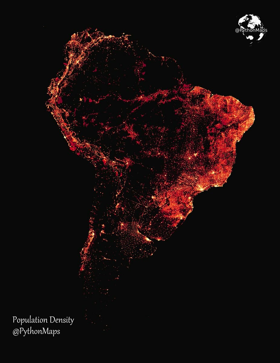
RT @PythonMaps
Population density of South America! I used GHSL data with Rasterio/Matplotlib to produce this. Why don't you have a go and post your maps in the comments!
#SouthAmerica #PopulationDensity #Map #Demographics #Urbanization #CityLife #Countryside #CensusData #Insightful #Geography
#SouthAmerica #populationdensity #map #demographics #Urbanization #citylife #countryside #censusdata #insightful #geography

Mzee · @Carlton
13 followers · 35 posts · Server universeodon.com
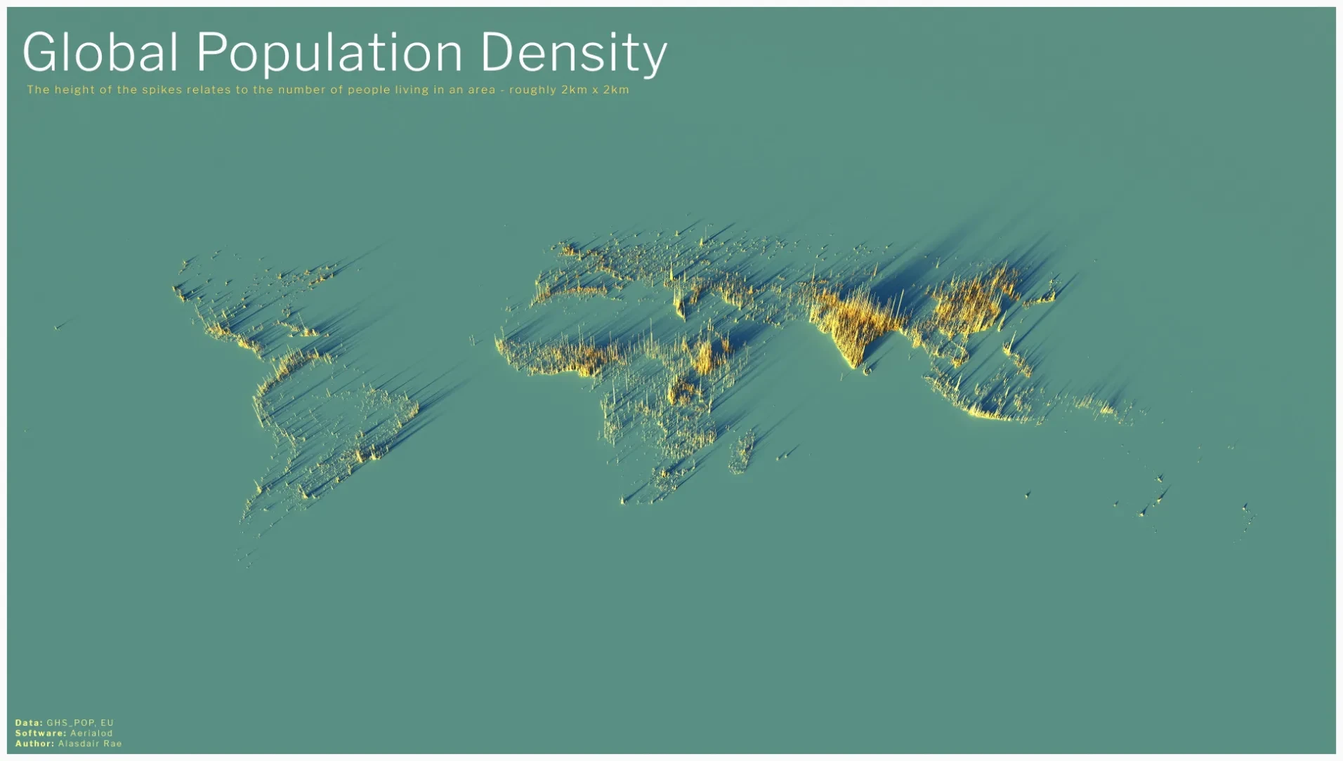
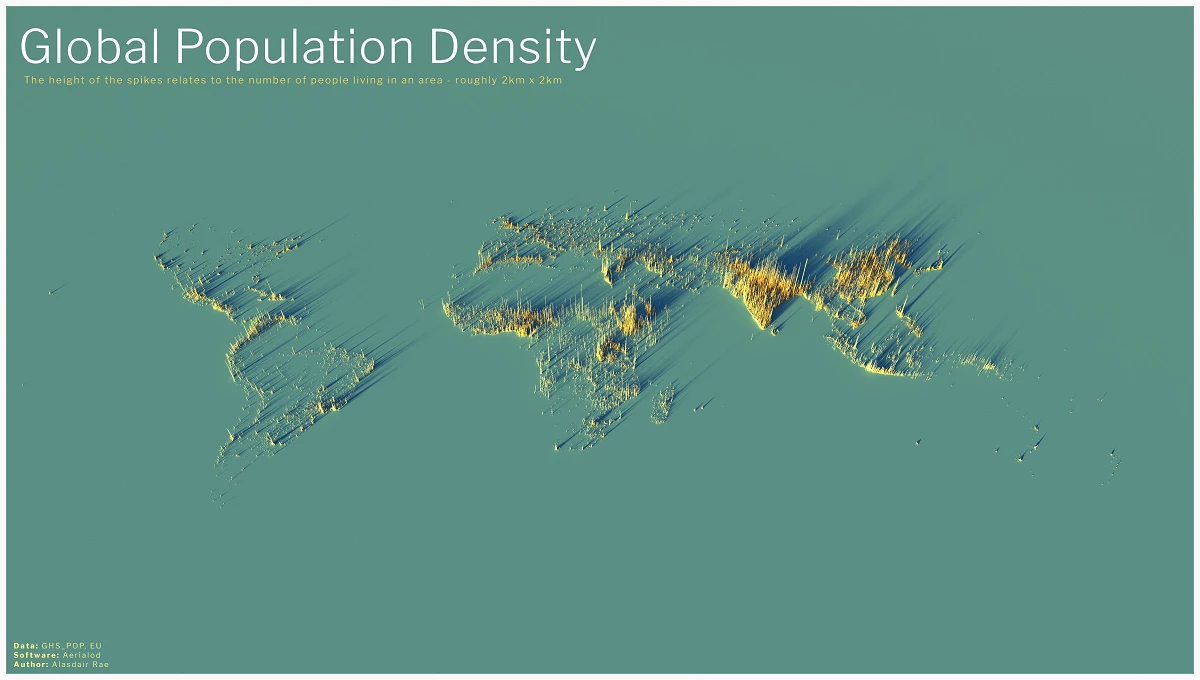
Global Population Density

Sven S. Svensson · @wegonnaseeno
85 followers · 305 posts · Server thepit.socialOne often hears that places like Montgomery County are ‘crowded’ and ‘overpopulated.’
People are missing the forest for the trees. These places aren’t crowded because of the amount of people. It’s because of the fucking CARS. It’s always the cars. Take the cars away and everything will feel empty. #transportation #Transpodon #populationdensity
#populationdensity #Transpodon #transportation

Cees Grootes · @analyticus
576 followers · 364 posts · Server mastodon.social
A 3D Look at the Largest Population Density Centers.
It can be difficult to comprehend the true sizes of megacities, or the global spread of 8 billion people, but this series of population density maps makes the picture abundantly clear.
Created using the EU’s population density data and mapping tool Aerialod by Alasdair Rae, the 3D-rendered maps highlight demographic trends and geographic constraints.
https://www.visualcapitalist.com/cp/3d-mapping-the-worlds-largest-population-densities/
#statistics #population #world #populationdensity #globalpopulation
#statistics #population #world #populationdensity #Globalpopulation