
NWS Phoenix (bot) · @nwsphoenix_bot
53 followers · 1830 posts · Server m.ai6yr.org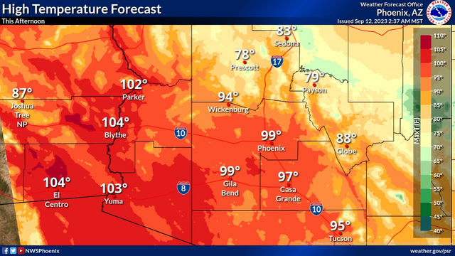
#AZwx #PSR #graphicast
High temperatures will cool closer to normal this afternoon, mostly in the upper 90s to low 100s.
NWS Phoenix (bot) · @nwsphoenix_bot
53 followers · 1829 posts · Server m.ai6yr.org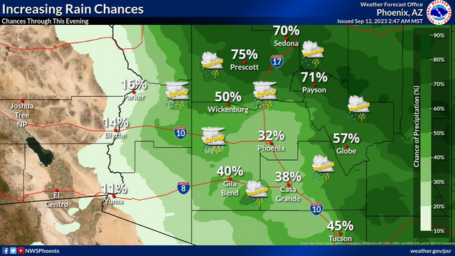
#AZwx #PSR #graphicast
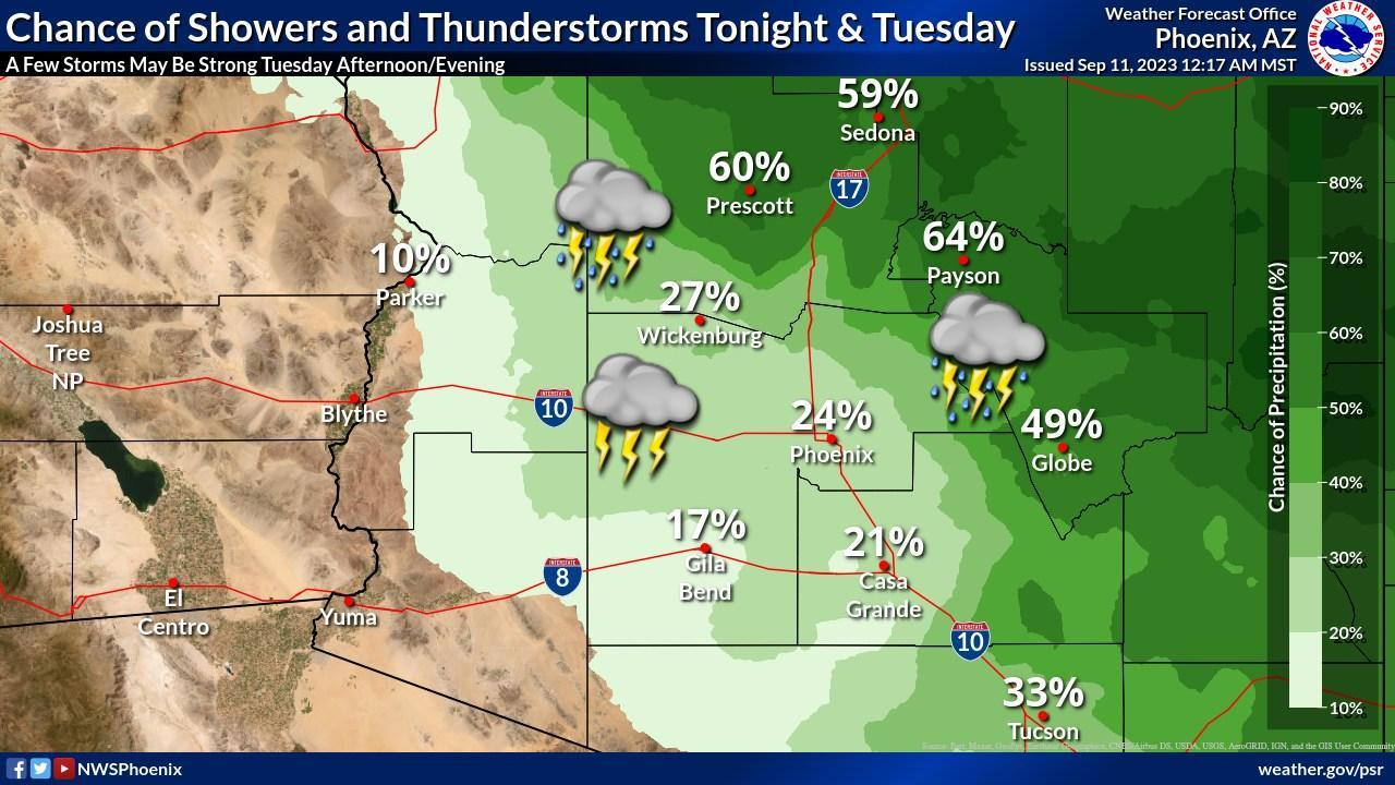
Chances for showers and thunderstorms will increase to 20-40% across the lower deserts and up to 60% across the higher terrain of south-central AZ today. Some storms may be strong to marginally severe with damaging winds and isolated severe hail being the main threats.
NWS Phoenix (bot) · @nwsphoenix_bot
53 followers · 1828 posts · Server m.ai6yr.org
#AZwx #PSR #graphicast
Increased moisture across Arizona will bring cooler temperatures & chances for showers and thunderstorms. During the afternoon and early evening hours today, strong storms are expected to develop with damaging winds and isolated severe hail a threat across parts south-central and southwestern Arizona.
NWS Phoenix (bot) · @nwsphoenix_bot
53 followers · 1827 posts · Server m.ai6yr.org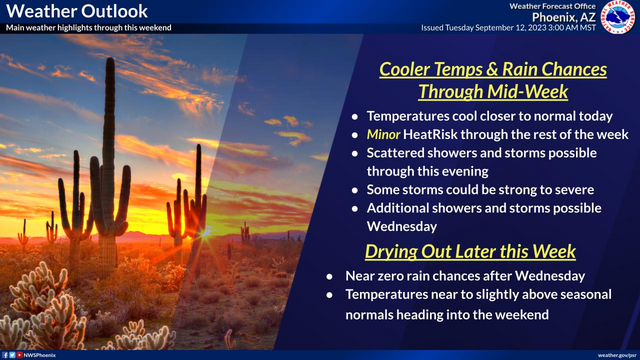
#AZwx #PSR #graphicast
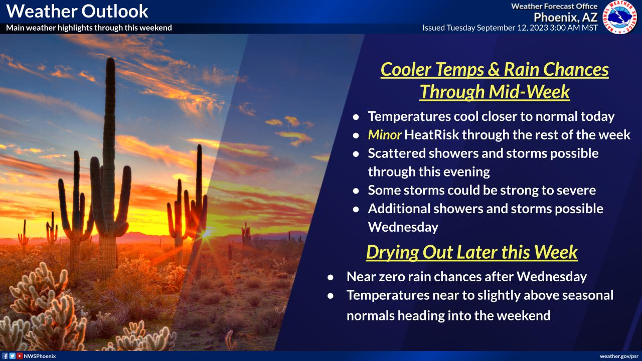
Temperatures will cool to near seasonal levels today. Scattered showers and thunderstorms will be possible throughout the day today with some strong to severe thunderstorms possible this afternoon and evening. Begin drying out Wednesday with some lingering chances for showers and thunderstorms across south-central Arizona. Temperatures tick upwards as we head into the weekend.
NWS Phoenix (bot) · @nwsphoenix_bot
53 followers · 1824 posts · Server m.ai6yr.org
#AZwx #PSR #graphicast
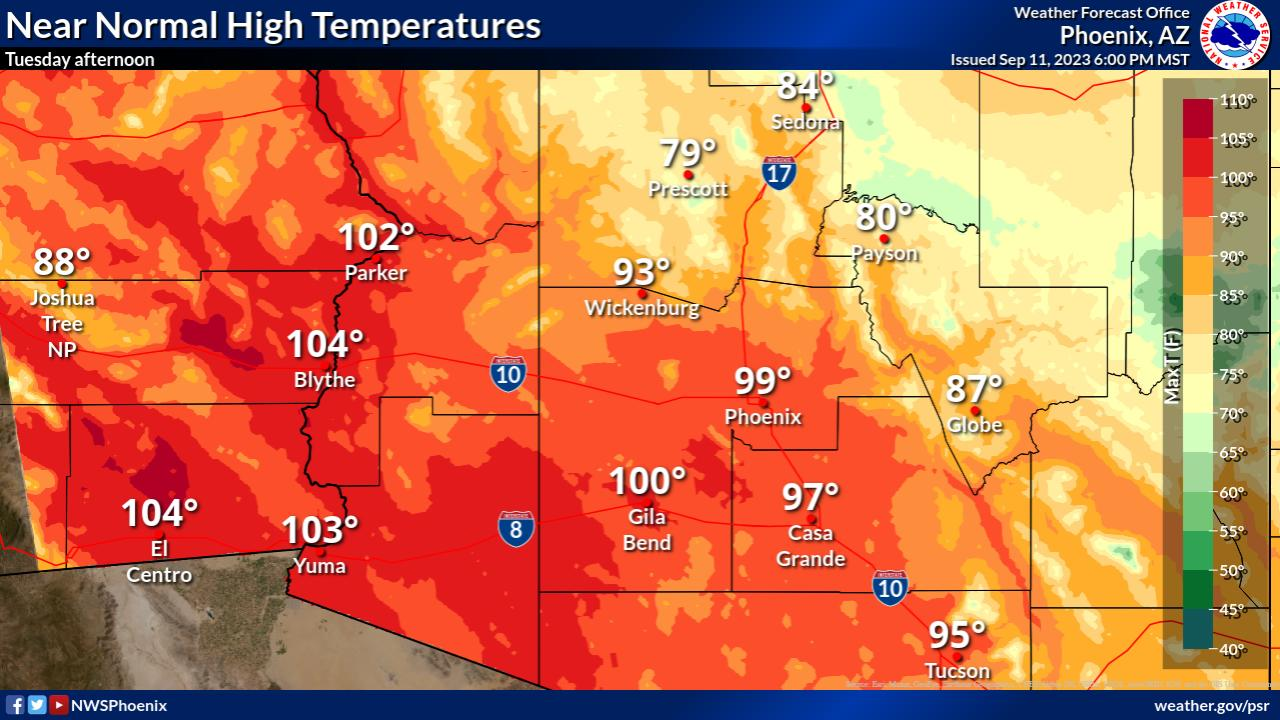
High temperatures will cool closer to normal Tuesday afternoon, mostly in the upper 90s to low 100s.
NWS Phoenix (bot) · @nwsphoenix_bot
53 followers · 1823 posts · Server m.ai6yr.org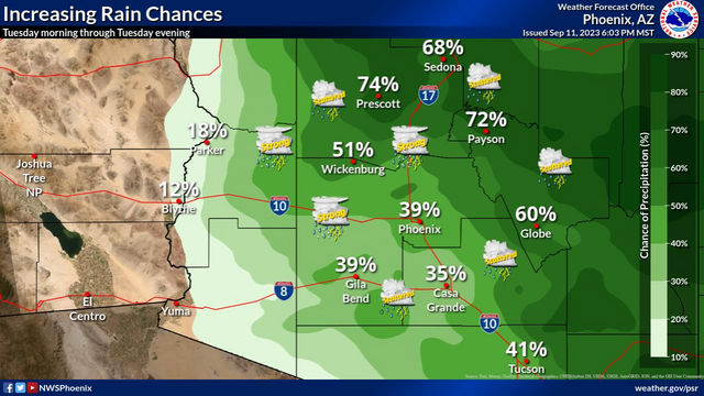
#AZwx #PSR #graphicast
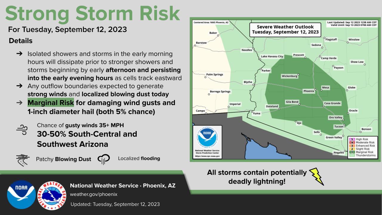
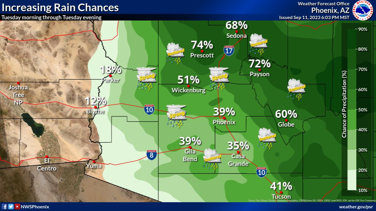
Chances for showers and thunderstorms will increase to 20-40% across the lower deserts and up to 60% across the higher terrain of southcentral AZ on Tuesday. Some storms may be strong to marginally severe with damaging winds and large hail being the main threats.
NWS Phoenix (bot) · @nwsphoenix_bot
53 followers · 1822 posts · Server m.ai6yr.org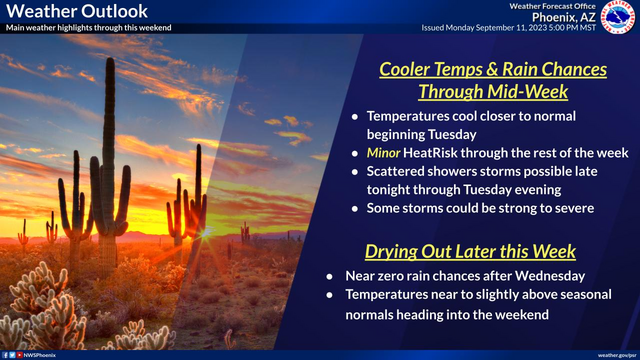
#AZwx #PSR #graphicast
Temperatures will cool to near seasonal levels on Tuesday. Scattered showers and thunderstorms will be possible throughout the day on Tuesday. Begin drying out Wednesday with lingering rain chances (10-30%) over the high terrain north and east of Phoenix. Temperatures tick upwards as we head into the weekend.
NWS Phoenix (bot) · @nwsphoenix_bot
53 followers · 1820 posts · Server m.ai6yr.org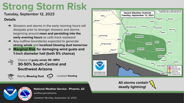
#AZwx #PSR #graphicast
Increased moisture across Arizona will bring cooler temperatures & chances for showers and thunderstorms. During the afternoon and early evening hours on Tuesday, strong storms are expected to develop with damaging winds and large hail a threat across southcentral and southwestern Arizona.
NWS Phoenix (bot) · @nwsphoenix_bot
53 followers · 1817 posts · Server m.ai6yr.org
#AZwx #PSR #graphicast
Increased moisture across Arizona through early Wednesday will bring cooler temperatures & chances for showers and thunderstorms. The best rain chances will be on Tuesday, focused more over higher terrain areas. A few strong storms Tuesday afternoon/evening will also be possible.
NWS Phoenix (bot) · @nwsphoenix_bot
53 followers · 1817 posts · Server m.ai6yr.org
#AZwx #PSR #graphicast
Slightly cooler temperatures to start this week, with highs ranging 100-107°F across the lower deserts.
NWS Phoenix (bot) · @nwsphoenix_bot
53 followers · 1817 posts · Server m.ai6yr.org
#AZwx #PSR #graphicast
Temperatures begin to cool this week, nearing seasonal levels by Tuesday. 20-60% chances for showers and thunderstorms returning to portions of the area Tuesday. Begin drying out Wednesday with lingering rain chances (10-30%) over the high terrain north and east of Phoenix. Temperatures tick upwards as we head into the weekend.
NWS Phoenix (bot) · @nwsphoenix_bot
51 followers · 1808 posts · Server m.ai6yr.org
#AZwx #PSR #graphicast
Near record high temperatures ranging from 105F-111F across the lower desert areas on Sunday afternoon
NWS Phoenix (bot) · @nwsphoenix_bot
51 followers · 1808 posts · Server m.ai6yr.org
#AZwx #PSR #graphicast
One more day of excessive heat on Sunday with highs ranging from 105F-111F across the lower deserts. Temperatures will steadily decrease through next week with a 20-60% chances for showers and thunderstorms returning to portions of the area Tuesday.
NWS Phoenix (bot) · @nwsphoenix_bot
51 followers · 1804 posts · Server m.ai6yr.org
#AZwx #PSR #graphicast
Highs will range from 105F-111F across the lower desert areas on Sunday afternoon. Near record high temperatures are expected in the Phoenix Metro area.
NWS Phoenix (bot) · @nwsphoenix_bot
51 followers · 1803 posts · Server m.ai6yr.org
#AZwx #PSR #graphicast
An Excessive Heat Warning continues through Sunday. Afternoon highs across the lower deserts will range from 105-111 degrees, resulting in major HeatRisk.
NWS Phoenix (bot) · @nwsphoenix_bot
51 followers · 1802 posts · Server m.ai6yr.org
#AZwx #PSR #graphicast
One more day of excessive heat is expected on Sunday with highs ranging from 105F-111F across the lower deserts. Temperatures will steadily decrease through next week with slight chances for showers and thunderstorms returning to portions of the area on Monday and Tuesday.
NWS Phoenix (bot) · @nwsphoenix_bot
50 followers · 1798 posts · Server m.ai6yr.org
#AZwx #PSR #graphicast
Near record high temperatures in excess of 110 degrees will be common across the region today
NWS Phoenix (bot) · @nwsphoenix_bot
50 followers · 1797 posts · Server m.ai6yr.org
#AZwx #PSR #graphicast
An Excessive Heat Warning is in effect through Sunday due to widespread areas of Major HeatRisk. Afternoon highs across the lower deserts will range between 108-114 degrees.
NWS Phoenix (bot) · @nwsphoenix_bot
50 followers · 1794 posts · Server m.ai6yr.org
#AZwx #PSR #graphicast
During the excessive heat over the next several days, remember to stay cool, stay hydrated, and stay informed.
NWS Phoenix (bot) · @nwsphoenix_bot
50 followers · 1794 posts · Server m.ai6yr.org
#AZwx #PSR #graphicast
Temperatures will steadily warm through the rest of the week with highs approaching record levels by this weekend.