
Bernhard Höfle · @BernhardHofle
42 followers · 15 posts · Server mastodon.world
From forest stand information to laser scanning #pointclouds without a real scanner?
📢 📰 In our new paper by Schäfer et al. (https://doi.org/10.1093/forestry/cpad006) we generate realistic laser scanning data of forests by combining
➡️ forest stand information ℹ️
➡️ the #pytreedb tree point cloud database 🌳(https://pytreedb.geog.uni-heidelberg.de)
➡️ and the laser scanning simulator #HELIOS++ 🖥️(https://github.com/3dgeo-heidelberg/helios)
Such simulated data may be used in sensitivity analyses, for algorithm development, and for #machinelearning.
#pointclouds #pytreedb #Helios #machinelearning
Bernhard Höfle · @BernhardHofle
34 followers · 9 posts · Server mastodon.world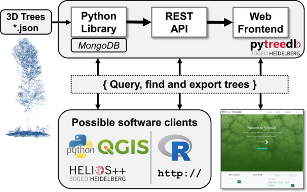
📢 1st release (v1.0.0) of #pytreedb, our #python #package providing an object-based database to store trees that were captured as 3D point clouds. 🌳
Test it: pip install pytreedb
DOI: https://doi.org/10.5281/zenodo.7551309
GitHub: https://github.com/3dgeo-heidelberg/pytreedb
#syssifoss #opensource
#pytreedb #python #package #syssifoss #opensource