
Instrument_Data · @Instrument_Data
24 followers · 1053 posts · Server livellosegreto.itQuelli di QGIS hanno annunciato che ora Mastodon sarà il loro mezzo per le news e non più Twitter

Lost Mapper · @lostmapper
8 followers · 14 posts · Server mapstodon.spaceSince I'm often adding the same XYZ Tiles to my installations of #QGIS I went and automated turning a CSV file of sources into a QGIS Connections file that you can just download, open and add. No more filling in multiple dialog boxes!
https://lostmapper.com/qgis-xyz-tiles/
Currently it's just the various Google Maps tiles available but I'll be adding more as I discover and confirm them. Let me know which ones you like to use!
Lost Mapper · @lostmapper
8 followers · 14 posts · Server mapstodon.space
My first video is up - Getting Started with QGIS: https://youtu.be/mM9AJxKkpH0 #gis #qgis #cartography #maps

z3z · @z3z
151 followers · 202 posts · Server mastodon.scot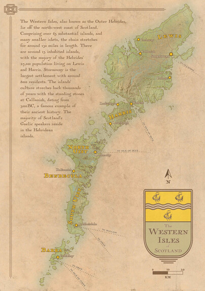
Another wee #map, this time showing the Outer Hebrides, the Western Isles of #Scotland.
Made with #QGIS and #Inkscape with a helping hand from #OpenStreetMap
I had a lot of fun with this one. Hope you like!
#maps #cartography #WesternIsles #hebrides #mapmaking #openstreetmap #inkscape #qgis #scotland #map

Corvus · @Corvus
49 followers · 534 posts · Server fosstodon.org@rjhale1971 I've had good experience stuffing a lot into a geopackage. Agreed it lacks the functionality of PostGIS but for contained geospatial mapping projects that are easily portable between QGIS users with various experience levels using databases it works well.
#gpkg #qgis

· @gishubio
3 followers · 15 posts · Server fosstodon.org
Counting points in polygons with a QGIS processing model
https://www.gishub.io/2023/09/08/counting-points-in-polygons-with-a-qgis-processing-model/

Rafagas Links · @rafagaslinks
205 followers · 565 posts · Server en.osm.town
A QGIS plugin that uses the Segment Anything Model (SAM) to facilitate and speed up the segmentation or delineation of landforms in geospatial raster images #qgis

Panda · @panda
449 followers · 11946 posts · Server freiburg.socialProjektleiterIn #Gis (de fakto #QGIS) gesucht in #Freiburg #Lörrach gesucht
https://badenova-gruppe.talentry.com/share/job/366128/647496/1694153290/3

timlinux · @timlinux
276 followers · 40 posts · Server fosstodon.orgMaking a map in #QGIS for publication - I compressed the video down to 50 seconds!

SK53 · @SK53
133 followers · 484 posts · Server en.osm.townPondering on ways to use DB scan clustering and wondered if one can constrain the clustering in any way (#15minuteCities could be an example). Turns out there's a decent literature out there, e.g., https://www.researchgate.net/publication/333709045_Density-based_clustering_with_constraints. Look foward to finding implementations in a few years in #QGIS #PostGIS 😀
#15minutecities #qgis #postgis

Ryan Aherin · @r_aherin
55 followers · 61 posts · Server mapstodon.space
Great workshop with @stevefaeembra on making 3D maps in blender #foss4guk #qgis #gischat

BNHR.XYZ :tux: :qgis: · @bnhrdotxyz
70 followers · 58 posts · Server fosstodon.org
Interested in a custom QGIS, PostGIS, GeoNode, Web Mapping, or Data Literacy course for your organization?
Get in touch by sending us a message or visiting https://bnhr.xyz/#contact
#Training #Learning #GIS #QGIS #FOSS4G #Exploration #Mining #MinEx #Geology #OpenSource #GISChat
#training #learning #gis #qgis #foss4g #exploration #mining #minex #geology #opensource #gischat
BNHR.XYZ :tux: :qgis: · @bnhrdotxyz
70 followers · 58 posts · Server fosstodon.org
The participants also got their hands on brand new BNHR workbooks: Advanced Styling and Symbology and Working with Maps and Layouts with more than 25 exercises for learning how to be a visualization and map-making maestro with QGIS!
#Training #Learning #GIS #QGIS #FOSS4G #Exploration #Mining #MinEx #Geology #OpenSource #GISChat
#training #learning #gis #qgis #foss4g #exploration #mining #minex #geology #opensource #gischat
BNHR.XYZ :tux: :qgis: · @bnhrdotxyz
70 followers · 56 posts · Server fosstodon.org
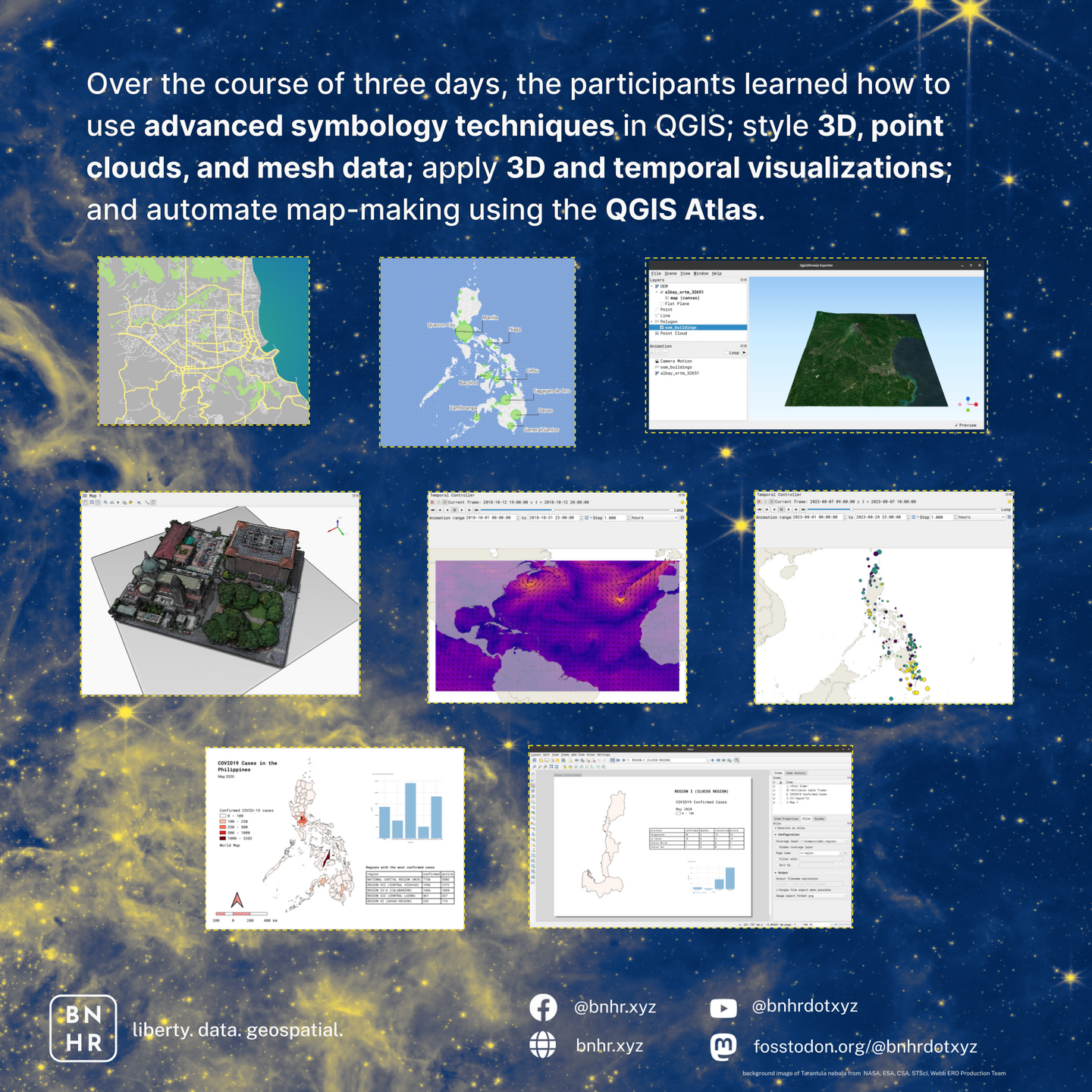
BNHR believes in learning by doing and working with actual data so our training courses are very exercise-driven. Over the course of three days, the participants learned how to use advanced symbology techniques in QGIS; style 3D, point clouds, and mesh data; apply 3D and temporal visualizations; and automate map-making using the QGIS Atlas.
#Training #Learning #GIS #QGIS #FOSS4G #Exploration #Mining #MinEx #Geology #OpenSource #GISChat
#training #learning #gis #qgis #foss4g #exploration #mining #minex #geology #opensource #gischat
BNHR.XYZ :tux: :qgis: · @bnhrdotxyz
70 followers · 55 posts · Server fosstodon.org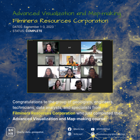
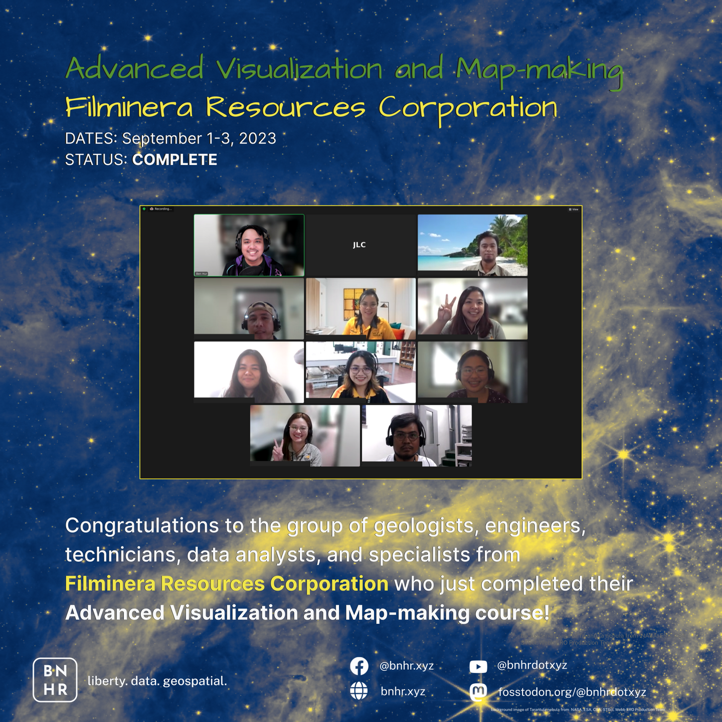
ADVANCED VISUALIZATION AND MAP-MAKING WITH QGIS FOR FILMINERA RESOURCES CORPORATION
Dates: September 1-3, 2023
Status: Complete
Congratulations once again to the group of geologists, engineers, technicians, data analysts, and specialists from Filminera Resources Corporation (FRC) who just completed their Advanced Visualization and Map-making with QGIS course!
#Training #Learning #GIS #QGIS #FOSS4G #Exploration #Mining #MinEx #Geology #OpenSource #GISChat
#training #learning #gis #qgis #foss4g #exploration #mining #minex #geology #opensource #gischat
AndrewFrench · @andrewfrench
68 followers · 60 posts · Server fosstodon.org

Hernán De Angelis · @hdeangelis
0 followers · 2 posts · Server mstdn.socialGeologist & physical geographer. Works with data analysis, data management and visualization within spatial data, GIS, remote sensing, metadata. Happy outside in Nature.
Likes #geoscience #environmentalscience #remotesensing #gis #FOSS #dataanalysis #geospatial #copernicus #OpenStreetMap #grassgis #qgis #GenericMappingTools #perl #python #gnuplot #imagemagick #spatial #OpenSource #openscience #datamanagement #datavisualization #Linux #amateurastronomy #running #cycling
#presentation #Cycling #Running #amateurastronomy #Linux #datavisualization #datamanagement #openscience #OpenSource #spatial #imagemagick #gnuplot #Python #perl #genericmappingtools #qgis #grassgis #OpenStreetMap #copernicus #geospatial #dataanalysis #FOSS #gis #remotesensing #environmentalscience #geoscience
Hernán De Angelis · @hdeangelis
0 followers · 1 posts · Server mstdn.socialGeolog & naturgeograf. Arbetar med dataanalys, informationshantering och visualisering inom geodata, gis, fjärranalys, metadata. Gärna ute i naturen på fritiden.
Gillar #geoscience #environmentalscience #remotesensing #gis #FOSS #dataanalysis #geospatial #copernicus #OpenStreetMap #grassgis #qgis #GenericMappingTools #perl #python #gnuplot #imagemagick #spatial #OpenSource #openscience #datavisualization #Linux #amateurastronomy #running #cycling
#presentation #Cycling #Running #amateurastronomy #Linux #datavisualization #openscience #OpenSource #spatial #imagemagick #gnuplot #Python #perl #genericmappingtools #qgis #grassgis #OpenStreetMap #copernicus #geospatial #dataanalysis #FOSS #gis #remotesensing #environmentalscience #geoscience

Alessandro Palmas · @Ale_Zena_IT
15 followers · 66 posts · Server mastodon.unoQuando pensi che tutto sta per andare a rotoli, fermati: è già andato tutto a rotoli!
Oggi il nostro management ci informa che ora abbiamo a disposizione ArcGis for Microsoft365
Per chi, come me, usa #Linux, #LibreOffice e #QGIS, è il colpo finale.
Abbattetemi subito per favore.

QGIS Gebruikers Nederland · @qgisnl
17 followers · 15 posts · Server mapstodon.space📢 Volgende week is het alweer zover: de #FOSS4GNL 2023 conferentie op 13 en 14 september in Middelburg! Dit is hét evenement voor iedereen die geïnteresseerd is in open source geo-software :qgis: :gdal: :grass: :postgis: :osgeo: . En natuurlijk zijn er ook veel interessante #QGIS presentaties! Mis het niet en meld je snel aan op https://foss4g.nl/!