
BakersRelay · @BakerRL75
779 followers · 31183 posts · Server m.ai6yr.org#EAS for Riverside: The current evacuation ORDER area East of Jack Rabbit Trail, North of Gilman Springs Road, South of West 1st Street and West of California Avenue/Highway 79 is reduced to an evacuation WARNING. All roads are now open. Please drive cautiously as our firefighters are still working on full containment and control of the fire. Source: Public Alert System** DO NOT RELY ON THIS FEED FOR LIFE SAFETY, SEEK OUT OFFICIAL SOURCES ***
BakersRelay · @BakerRL75
775 followers · 30675 posts · Server m.ai6yr.org#RabbitFire
Liam Winstead Jul 17, 3:25 PM
From Cal Fire RRU: The following two evacuation ORDER zones are downgraded to evacuation WARNINGS. Please see the updated evacuation map at https://bit.ly/rabbitfireevacs ZONE 1: South of Seneca Springs East of Highway 79 West of Manzanita Park Road North of Forest Boundary Road ZONE 2: South of East 1st Street East of Olive Avenue West of Highway 79 North of California Ave/Highway 79 CALIFORNIA AVE FROM EAST 1st STREET TO HIGHWAY 79 REMAINS CLOSED

AI6YR · @ai6yr
4194 followers · 25646 posts · Server m.ai6yr.org
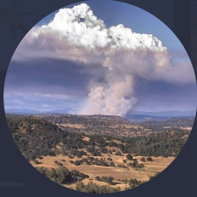
Update on #RabbitFire in #RiversideCounty #wildfires #CAwx
#rabbitfire #riversidecounty #wildfires #cawx

Geewhizpat · @Geewhizpat
849 followers · 2602 posts · Server newsie.socialFirefighters battling #RabbitFire in California's Riverside country, over 7000 acres burnt so far #RabbitFIRE **07/16/23 UPDATE 12:00 PM** Evacuation ORDER area is downgraded to an evacuation WARNING in the following areas:
South of East 1st Street
East of Highway 79/Lamb Canyon
North of Seneca Springs
West of Manzanita Park Road
Please see map here:
VC: Battalion 6 via Instagram
#Wildfire #CaliforniaWildfire #Riverside #Heatwave #RabbitFire #Beaumont
#rabbitfire #wildfire #californiawildfire #riverside #heatwave #beaumont
BakersRelay · @BakerRL75
774 followers · 30568 posts · Server m.ai6yr.org#EAS for Riverside: Evacuation Order area is downgraded to an Evacuation Warning in the following areas South of East 1st St, East of HWY 79 North of Seneca Springs, West of Manzanita Park Rd Source: Public Alert System** DO NOT RELY ON THIS FEED FOR LIFE SAFETY, SEEK OUT OFFICIAL SOURCES ***

Tay · @Tay
141 followers · 413 posts · Server m.ai6yr.org[NBC News]
Firefighters are leaving the U.S. Forest Service for better pay and benefits
https://nbcnews.com/news/us-news/firefighters-are-leaving-us-forest-service-better-pay-benefits-rcna93689
#wildfires #rabbitfire #socal #NorCal
Tay · @Tay
141 followers · 412 posts · Server m.ai6yr.orgThis is from Amber who's the wife of a #HotShot & she's been filling me in. #SoCal...#NorCal plz sign this petition. RT it, post it on FB, Insta....but this has got to be changed bcuz your lives & homes may depend on it.
http://grassrootswildlandfirefighters.com
#SanBernardino Forestry has has already closed some of it's stations due to lack of man power. And for everyone who leaves puts many more in danger.
Please sign the petition & keep #California safe.
#hotshot #socal #NorCal #sanbernardino #california #rabbitfire #wildfires #hotshots
BakersRelay · @BakerRL75
774 followers · 30568 posts · Server m.ai6yr.org
#RabbitFire #Riverside #FireWx
Liam Winstead Jul 16, 3:21 PM
The evacuation order has been downgraded to an evacuation warnings for the area South of East 1st Street, East of Highway 79/Lamb Canyon, North of Seneca Springs, West of Manzanita Park Road. Please see the updated evacuation map at https://bit.ly/rabbitfireevacs
#rabbitfire #riverside #FireWx
IntelEarth · @Intel_Earth
122 followers · 115 posts · Server m.ai6yr.orgFinal update for the night unless a number change occurs(acre, containment, evac order).
Calling it a night. Have a good day, be safe, and be kind all.
-IntelEarth
#RabbitFire
#GavilanFire
IntelEarth · @Intel_Earth
122 followers · 114 posts · Server m.ai6yr.orgLast tankers being put on a load and hold for the #GavilanFire copters will continue working
Tankers released for the #RabbitFire copters working and the Helitankers will arrive soon

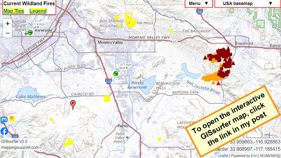
Joseph Elfelt · @mappingsupport
303 followers · 214 posts · Server m.ai6yr.org
July 15 6pm PDT. Interactive #GIS map.
Dark red symbols are latest MODIS/VIIRS satellite *heat* detection for #RabbitFire Riverside County, CA.
Red marker is general location of #GavilanFire. Too new to show up in the MODIS/VIIRS data.
Green symbol (clickable) near map center has some near real time weather data.
#CAfire #CAwx #CAwildfire #Geospatial #Maps #Mapping #Leaflet #ArcGIS #WebMap
Open #GISsurfer map:
https://mappingsupport.com/p2/gissurfer.php?center=33.850801,-117.191162&zoom=11&basemap=USA_basemap&overlay=State_boundary,MODIS_7_day,VIIRS_7_day,Forecast_discussion,Wind_temperature_and_more...&data=https://mappingsupport.com/p2/special_maps/disaster/USA_wildland_fire.txt||33.811674,-117.339477
#gis #rabbitfire #gavilanfire #cafire #cawx #cawildfire #geospatial #maps #mapping #leaflet #arcgis #webmap #gissurfer
BakersRelay · @BakerRL75
770 followers · 30054 posts · Server m.ai6yr.org#RabbitFire #RiversideCounty #FireWx
Cole Euken - Jul 15, 6:58 PM
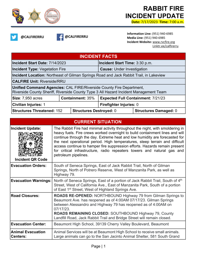
Per CalFire RRU - Evacuation Warning Area Expanded: - North of East 1st Street East of Jack Rabbit Trail South of West 4th Street West of California Avenue - East of Manzanita Park Road West of Highland Springs Road South of East 1st Street North of Forest Boundary Line. Use the interactive map found HERE: http://linktr.ee/calfirerru to see if you are in an affected area.
#rabbitfire #riversidecounty #FireWx
BakersRelay · @BakerRL75
770 followers · 30054 posts · Server m.ai6yr.org
#RabbitFire #RiversideCounty #FireWx
Per CalFire RRU - 3:40 p.m. - Two previous Evacuation Warning Zones are now under Evacuation Orders. North and West of Highway 79 (Lambs Canyon), East of California Avenue and South of First Street. North of County Landfill (Lamb Canyon Road), East of Highway 79 (Lambs Canyon), South of E. First Street and West of Manzanita Park Road. Follow this link to search if you are in an affected area: http://linktr.ee/calfirerru
#rabbitfire #riversidecounty #FireWx
BakersRelay · @BakerRL75
770 followers · 30020 posts · Server m.ai6yr.org#RabbitFire #RiversideCounty #FireWx Gilman Springs Rd × Jack Rabbit Trail - Moreno Valley - https://share.watchduty.org/i/6708
1/2 acre established spot fire on the East side of Hwy 79 South of California Ave. Ground and air resources working it.
Video From Fire Photo Girl on Twitter: The fire has jumped Highway 79. It is now on the east side of Highway 79.
https://twitter.com/FirePhotoGirl/status/1680338332314914816?s=20
#rabbitfire #riversidecounty #FireWx

MiBaWi - Michael Barthel · @MiBaWi
332 followers · 969 posts · Server m.ai6yr.org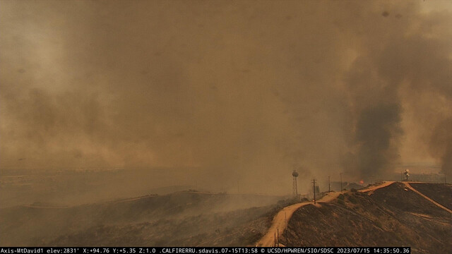
#RabbitFire > Moreno Valley, Riverside County / California
ANIMAL SHELTER & Resources
#Pets > Beaumont High School, 39139 Cherry Valley Boulevard, Beaumont
Large #animals > San Jacinto Animal Shelter, 581 South Grand Avenue, San Jacinto
Evac assistance > Riverside County Animal Services (951) 358-7387
MiBaWi - Michael Barthel · @MiBaWi
332 followers · 969 posts · Server m.ai6yr.org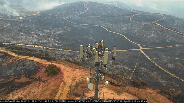
MiBaWi - Michael Barthel · @MiBaWi
332 followers · 969 posts · Server m.ai6yr.org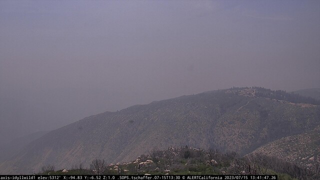
[NEW START] - #GibbelFire at 41000 block Gibbel Road in Hemet, Riverside County / California
.... not visible due to the smoke from the #Rabbitfire near #MorenoValley
#gibbelfire #rabbitfire #morenovalley
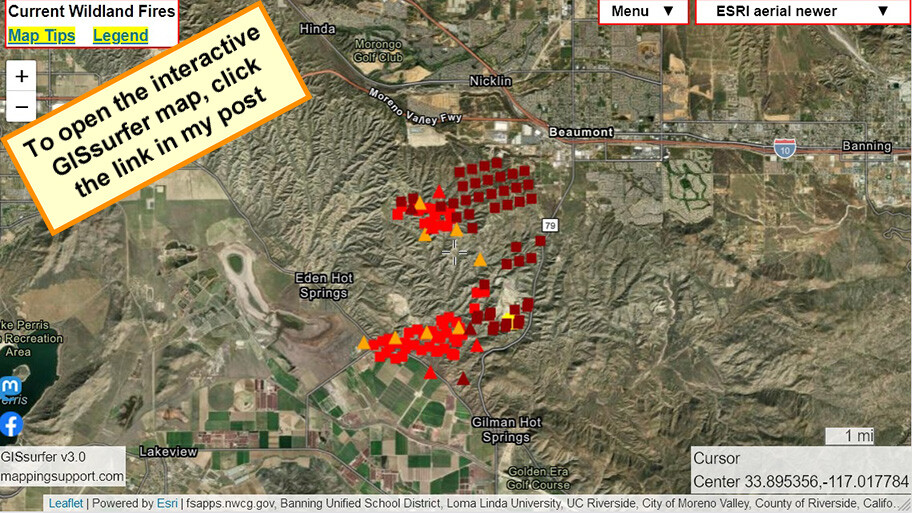
Joseph Elfelt · @mappingsupport
298 followers · 206 posts · Server m.ai6yr.org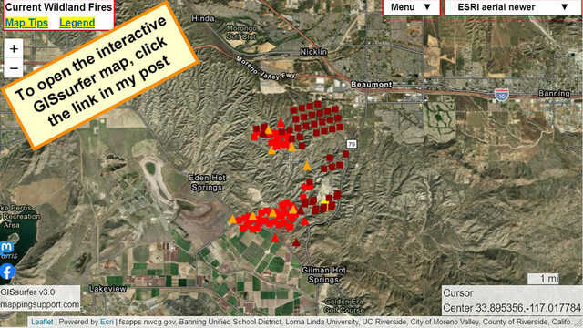
July 15 1:38pm PDT. Interactive #GIS map shows latest MODIS/VIIRS satellite *heat* detection for #RabbitFire Riverside County, CA. The uniform pattern suggests that some of this data may (or may not) be "false positive".
The map has a lot of fire related layers you can turn on. Need help? Click “Map tips” upper left corner.
#CAfire #CAwx #CAwildfire #Geospatial #Maps #Mapping #Leaflet #ArcGIS #WebMap
Open #GISsurfer map:
https://mappingsupport.com/p2/gissurfer.php?center=33.895356,-117.017784&zoom=12&basemap=ESRI_aerial_newer&overlay=VIIRS_7_day,MODIS_7_day,Wildland_fire_name,Fire_perimeter_NIFC&data=https://mappingsupport.com/p2/special_maps/disaster/USA_wildland_fire.txt
#gis #rabbitfire #cafire #cawx #cawildfire #geospatial #maps #mapping #leaflet #arcgis #webmap #gissurfer
BakersRelay · @BakerRL75
770 followers · 29979 posts · Server m.ai6yr.org@easwatch
#RabbitFire #RiversideCounty #FireWx
#EAS for Riverside: Evacuation Warning North of County Landfill (Lamb Canyon Road), East of Highway 79 (Lambs Canyon), South of E. First Street and West of Manzanita Park Road. Care and Reception Beaumont High School 39139 Cherry Valley Blvd, Beaumont San Jacinto Animal Shelter 581 S Grand Ave, San Jacinto Source: Public Alert System** DO NOT RELY ON THIS FEED FOR LIFE SAFETY, SEEK OUT OFFICIAL SOURCES ***
#rabbitfire #riversidecounty #FireWx #EAS
BakersRelay · @BakerRL75
770 followers · 29979 posts · Server m.ai6yr.org
#RabbitFire #RiversideCounty #Firewx
Gilman Springs Rd × Jack Rabbit Trail - Moreno Valley
Per CalFire RRU - An EVACUATION WARNING has been issued North of County Landfill (Lambs Canyon Road), East of Highway 79 (Lambs Canyon), South of E. First Street and West of Manzanita Park Road. Please avoid the area if possible and help
Refer to evacuation map from CAL FIRE Riverside here: https://bit.ly/rabbitfireevacs
#rabbitfire #riversidecounty #FireWx