
BakersRelay · @BakerRL75
867 followers · 36393 posts · Server m.ai6yr.org#EAS for Davidson, #NC; #Montgomery, #NC; #Randolph, #NC; #Stanly, #NC: National Weather Service: A FLASH #FLOOD WARNING is in effect for this area until 3:15 AM EDT. This is a dangerous and life-threatening situation. Do not attempt to travel unless you are fleeing an area subject to flooding or under an evacuation order. Source: NWS Raleigh NC** DO NOT RELY ON THIS FEED FOR LIFE SAFETY, SEEK OUT OFFICIAL SOURCES ***
#ncwx #EAS #nc #montgomery #randolph #stanly #flood

EAS Watcher · @easwatch
363 followers · 11540 posts · Server m.ai6yr.org
#EAS for Davidson, #NC; #Montgomery, #NC; #Randolph, #NC; #Stanly, #NC: National Weather Service: A FLASH #FLOOD WARNING is in effect for this area until 3:15 AM EDT. This is a dangerous and life-threatening situation. Do not attempt to travel unless you are fleeing an area subject to flooding or under an evacuation order. Source: NWS Raleigh NC** DO NOT RELY ON THIS FEED FOR LIFE SAFETY, SEEK OUT OFFICIAL SOURCES ***
#EAS #nc #montgomery #randolph #stanly #flood
EAS Watcher · @easwatch
363 followers · 11539 posts · Server m.ai6yr.org#EAS for Davidson, #NC; #Montgomery, #NC; #Randolph, #NC; #Stanly, #NC: National Weather Service: A FLASH #FLOOD WARNING is in effect for this area until 3:15 AM EDT. This is a dangerous and life-threatening situation. Do not attempt to travel unless you are fleeing an area subject to flooding or under an evacuation order. Source: NWS Raleigh NC** DO NOT RELY ON THIS FEED FOR LIFE SAFETY, SEEK OUT OFFICIAL SOURCES ***
#EAS #nc #montgomery #randolph #stanly #flood
EAS Watcher · @easwatch
331 followers · 9749 posts · Server m.ai6yr.org
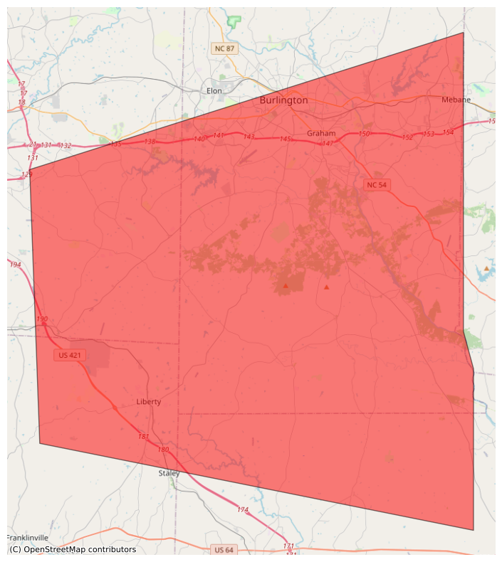
#EAS for Alamance, #NC; #Chatham, #NC; #Guilford, #NC; #Randolph, #NC: National Weather Service: SEVERE THUNDERSTORM WARNING in effect for this area until 4:15 PM EDT for DESTRUCTIVE 80 mph winds. Take shelter in a sturdy building, away from windows. Flying debris may be deadly to those caught without shelter. Source: NWS Raleigh NC** DO NOT RELY ON THIS FEED FOR LIFE SAFETY, SEEK OUT OFFICIAL SOURCES ***
#EAS #nc #chatham #guilford #randolph
EAS Watcher · @easwatch
331 followers · 9749 posts · Server m.ai6yr.org#EAS for Alamance, ###NC; ###Chatham, ###NC; ###Guilford, ###NC; ###Randolph, ###NC: National Weather Service: SEVERE THUNDERSTORM WARNING in effect for this area until 4:15 PM EDT for DESTRUCTIVE 80 mph winds. Take shelter in a sturdy building, away from windows. Flying debris may be deadly to those caught without shelter. Source: NWS Raleigh NC** DO NOT RELY ON THIS FEED FOR LIFE SAFETY, SEEK OUT OFFICIAL SOURCES ***
#EAS #nc #chatham #guilford #randolph
EAS Watcher · @easwatch
331 followers · 9749 posts · Server m.ai6yr.org#EAS for Alamance, ##NC; ##Chatham, ##NC; ##Guilford, ##NC; ##Randolph, ##NC: Severe Thunderstorm Warning issued August 15 at 3:29PM EDT until August 15 at 4:15PM EDT by NWS Raleigh NC Source: NWS Raleigh NC** DO NOT RELY ON THIS FEED FOR LIFE SAFETY, SEEK OUT OFFICIAL SOURCES ***
#EAS #nc #chatham #guilford #randolph
EAS Watcher · @easwatch
331 followers · 9749 posts · Server m.ai6yr.org#EAS for Alamance, #NC; #Chatham, #NC; #Guilford, #NC; #Randolph, #NC: Severe Thunderstorm Warning issued August 15 at 3:29PM EDT until August 15 at 4:15PM EDT by NWS Raleigh NC Source: NWS Raleigh NC** DO NOT RELY ON THIS FEED FOR LIFE SAFETY, SEEK OUT OFFICIAL SOURCES ***
#EAS #nc #chatham #guilford #randolph
EAS Watcher · @easwatch
331 followers · 9744 posts · Server m.ai6yr.org#EAS for Guilford, ###NC; ###Randolph, ###NC: National Weather Service: SEVERE THUNDERSTORM WARNING in effect for this area until 3:45 PM EDT for DESTRUCTIVE 80 mph winds. Take shelter in a sturdy building, away from windows. Flying debris may be deadly to those caught without shelter. Source: NWS Raleigh NC** DO NOT RELY ON THIS FEED FOR LIFE SAFETY, SEEK OUT OFFICIAL SOURCES ***
EAS Watcher · @easwatch
331 followers · 9744 posts · Server m.ai6yr.org
EAS Watcher · @easwatch
331 followers · 9743 posts · Server m.ai6yr.org
BakersRelay · @BakerRL75
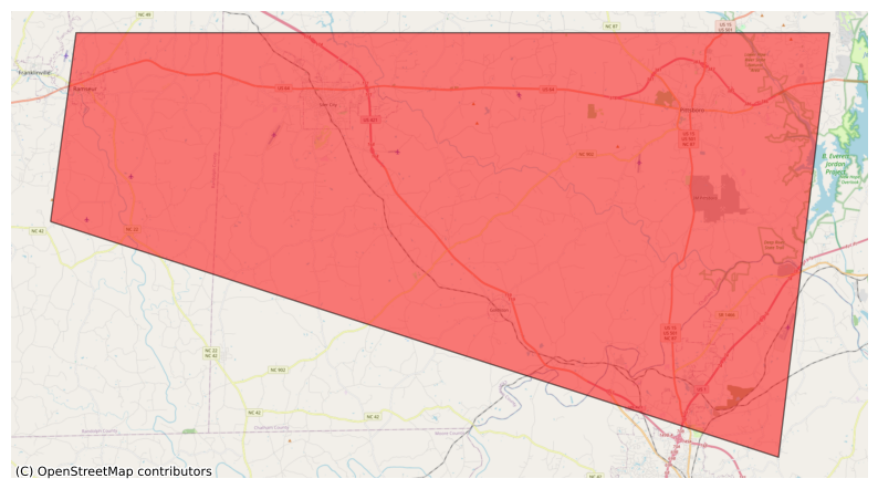
796 followers · 33322 posts · Server m.ai6yr.org#EAS for Chatham, #NC; #Lee, #NC; #Randolph, #NC: National Weather Service: #TORNADO WARNING in this area until 7:00 PM EDT. Take shelter now in a basement or an interior room on the lowest floor of a sturdy building. If you are outdoors, in a mobile home, or in a vehicle, move to the closest substantial shelter and protect yourself from flying debris. Check media. Source: NWS Raleigh NC** DO NOT RELY ON THIS FEED FOR LIFE SAFETY, SEEK OUT OFFICIAL SOURCES ***
#ncwx #EAS #nc #lee #randolph #tornado
EAS Watcher · @easwatch
322 followers · 8966 posts · Server m.ai6yr.org#EAS for Chatham, ##NC; ##Lee, ##NC; ##Randolph, ##NC: National Weather Service: #TORNADO WARNING in this area until 7:00 PM EDT. Take shelter now in a basement or an interior room on the lowest floor of a sturdy building. If you are outdoors, in a mobile home, or in a vehicle, move to the closest substantial shelter and protect yourself from flying debris. Check media. Source: NWS Raleigh NC** DO NOT RELY ON THIS FEED FOR LIFE SAFETY, SEEK OUT OFFICIAL SOURCES ***
#EAS #nc #lee #randolph #tornado
EAS Watcher · @easwatch
322 followers · 8966 posts · Server m.ai6yr.org
EAS Watcher · @easwatch
322 followers · 8966 posts · Server m.ai6yr.org
#EAS for Chatham, #NC; #Lee, #NC; #Randolph, #NC: National Weather Service: #TORNADO WARNING in this area until 7:00 PM EDT. Take shelter now in a basement or an interior room on the lowest floor of a sturdy building. If you are outdoors, in a mobile home, or in a vehicle, move to the closest substantial shelter and protect yourself from flying debris. Check media. Source: NWS Raleigh NC** DO NOT RELY ON THIS FEED FOR LIFE SAFETY, SEEK OUT OFFICIAL SOURCES ***
#EAS #nc #lee #randolph #tornado
BakersRelay · @BakerRL75
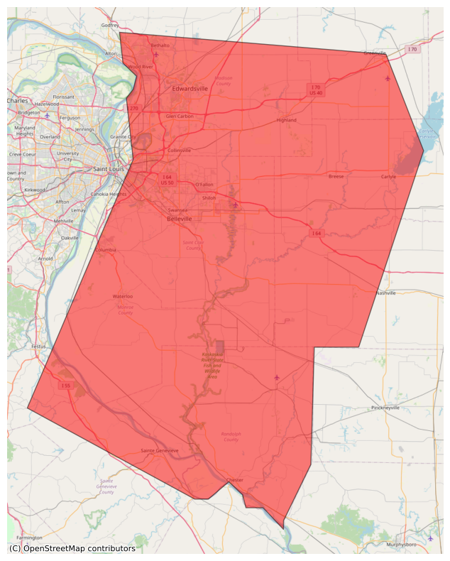
786 followers · 32762 posts · Server m.ai6yr.org#EAS for Bond, #IL; #Clinton, #IL; #Madison, #IL; #Monroe, #IL; #Randolph, #IL; #St. Clair, #IL; #Washington, #IL; #Jefferson, #MO; #Ste. Genevieve, #MO: National Weather Service: SEVERE THUNDERSTORM WARNING in effect for this area until 5:00 PM CDT for DESTRUCTIVE 80 mph winds. Take shelter in a sturdy building, away from windows. Flying debris may be deadly to those caught without shelter. Source: NWS St Louis MO** DO NOT RELY ON THIS FEED…
#ilwx #mowx #EAS #il #clinton #madison #monroe #randolph #st #washington #jefferson #mo #ste
EAS Watcher · @easwatch
316 followers · 8155 posts · Server m.ai6yr.org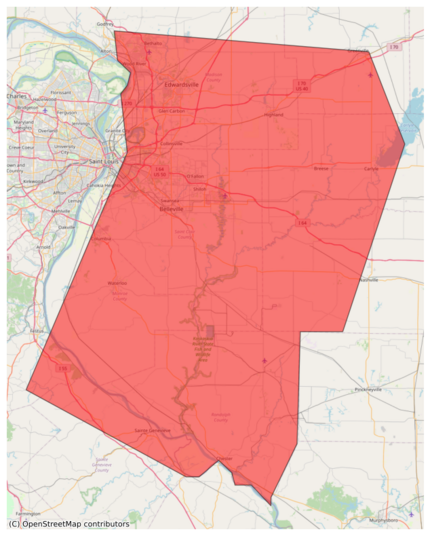
#EAS for Bond, #IL; #Clinton, #IL; #Madison, #IL; #Monroe, #IL; #Randolph, #IL; #St. Clair, #IL; #Washington, #IL; #Jefferson, #MO; #Ste. Genevieve, #MO: National Weather Service: SEVERE THUNDERSTORM WARNING in effect for this area until 5:00 PM CDT for DESTRUCTIVE 80 mph winds. Take shelter in a sturdy building, away from windows. Flying debris may be deadly to those caught without shelter. Source: NWS St Louis MO** DO NOT RELY ON THIS FEED FOR LIFE SAFETY, SEEK OUT OFFICIAL SOURCES ***
#EAS #il #clinton #madison #monroe #randolph #st #washington #jefferson #mo #ste
EAS Watcher · @easwatch
316 followers · 8154 posts · Server m.ai6yr.org#EAS for Bond, ##IL; ##Clinton, ##IL; ##Madison, ##IL; ##Monroe, ##IL; ##Randolph, ##IL; ##St. Clair, ##IL; ##Washington, ##IL; ##Jefferson, ##MO; ##Ste. Genevieve, ##MO: National Weather Service: SEVERE THUNDERSTORM WARNING in effect for this area until 5:00 PM CDT for DESTRUCTIVE 80 mph winds. Take shelter in a sturdy building, away from windows. Flying debris may be deadly to those caught without shelter. Source: NWS St Louis MO** DO NOT RELY ON THIS FEED FOR LIFE SAFETY, SEEK OUT OFFICIAL S
#EAS #il #clinton #madison #monroe #randolph #st #washington #jefferson #mo #ste
EAS Watcher · @easwatch
316 followers · 8154 posts · Server m.ai6yr.org#EAS for Bond, #IL; #Clinton, #IL; #Madison, #IL; #Monroe, #IL; #Randolph, #IL; #St. Clair, #IL; #Washington, #IL; #Jefferson, #MO; #Ste. Genevieve, #MO: Severe Thunderstorm Warning issued July 29 at 4:16PM CDT until July 29 at 5:00PM CDT by NWS St Louis MO Source: NWS St Louis MO** DO NOT RELY ON THIS FEED FOR LIFE SAFETY, SEEK OUT OFFICIAL SOURCES ***
#EAS #il #clinton #madison #monroe #randolph #st #washington #jefferson #mo #ste
BakersRelay · @BakerRL75
757 followers · 27734 posts · Server m.ai6yr.org#EAS for Alamance, #NC; #Chatham, #NC; #Guilford, #NC; #Randolph, #NC: National Weather Service: A FLASH #FLOOD WARNING is in effect for this area until 3:00 PM EDT. This is a dangerous and life-threatening situation. Do not attempt to travel unless you are fleeing an area subject to flooding or under an evacuation order. Source: NWS Raleigh NC** DO NOT RELY ON THIS FEED FOR LIFE SAFETY, SEEK OUT OFFICIAL SOURCES ***
#ncwx #EAS #nc #chatham #guilford #randolph #flood
EAS Watcher · @easwatch
277 followers · 7563 posts · Server m.ai6yr.org#EAS for Alamance, #NC; #Chatham, #NC; #Guilford, #NC; #Randolph, #NC: National Weather Service: A FLASH #FLOOD WARNING is in effect for this area until 3:00 PM EDT. This is a dangerous and life-threatening situation. Do not attempt to travel unless you are fleeing an area subject to flooding or under an evacuation order. Source: NWS Raleigh NC** DO NOT RELY ON THIS FEED FOR LIFE SAFETY, SEEK OUT OFFICIAL SOURCES ***
#EAS #nc #chatham #guilford #randolph #flood