GregCocks · @GregCocks
718 followers · 570 posts · Server techhub.socialRecord-Breaking North Atlantic Ocean Temperatures Contribute To Extreme Marine Heatwaves [remote sensing]
--
https://climate.copernicus.eu/record-breaking-north-atlantic-ocean-temperatures-contribute-extreme-marine-heatwaves <-- shared technical article
--
#GIS #spatial #mapping #spatialanalysis #spatiotemporal #climatechange #marine #marineconservation #marinelife #heatwave #NorthAtlantic #MarineHeatwave #fishing #fisheries #fisheriesmanagement #economics #economy #foodsecurity #watertemperature #waterquality #ecosystem #health #ecosystemchange #disease #remotesensing #satellite #climate #Copernicus #ESA @esa
#gis #spatial #mapping #spatialanalysis #spatiotemporal #climatechange #marine #marineconservation #marinelife #heatwave #northatlantic #marineheatwave #fishing #fisheries #fisheriesmanagement #economics #economy #FoodSecurity #watertemperature #waterquality #ecosystem #Health #ecosystemchange #disease #remotesensing #satellite #climate #Copernicus #Esa
AI6YR · @ai6yr
4815 followers · 33316 posts · Server m.ai6yr.orgVia @pierre_markuse: Look at this super-interesting and well-written fifth part of the Gentle Introduction to #GDAL series by @rsimmon, this time dealing with shaded relief. #remotesensing #gis #dataviz #cartography #remotesensing https://medium.com/@robsimmon/a-gentle-introduction-to-gdal-part-5-shaded-relief-ec29601db654
#gdal #remotesensing #gis #dataviz #cartography
Lars Kaleschke · @seaice
779 followers · 481 posts · Server det.socialNew preprint available
Kaleschke, L., Tian-Kunze, X., Hendricks, S., and Ricker, R.: SMOS-derived Antarctic thin sea-ice thickness: data description and validation in the Weddell Sea, Earth Syst. Sci. Data Discuss. [preprint], https://doi.org/10.5194/essd-2023-326, in review, 2023.
#Antarctic #SeaIce #RemoteSensing #SMOS #OpenScience #OpenData #OpenAccess
#antarctic #seaice #remotesensing #SMOS #openscience #opendata #openaccess
Genuinely Gary 🌤️ · @sgtgary
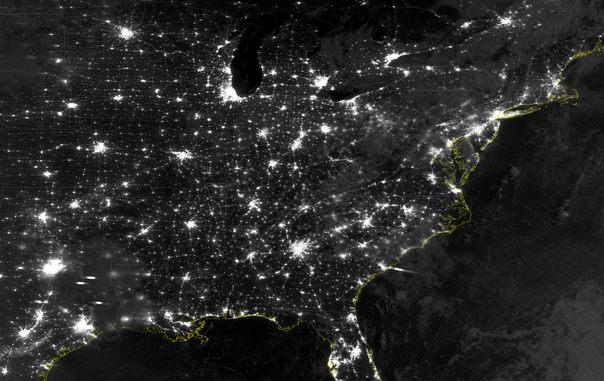
786 followers · 2792 posts · Server mindly.socialJust another nighttime view of city lights in the eastern 2/3 of the US from NOAA-20 VIIRS, collected 09 September at 0717 UTC #weather #RemoteSensing
GregCocks · @GregCocks
718 followers · 569 posts · Server techhub.socialExtensibility Of U-Net Neural Network Model For Hydrographic Feature Extraction And Implications For Hydrologic Modeling
--
https://doi.org/10.3390/rs13122368 <-- shared paper
--
#GIS #spatial #mapping #machinelearning #neuralnetwork #Unet #featureextraction #hydrography #hydrology #water #automation #remotesensing #surfacewater #NHD #bluelines #topography #deeplearning #AI #artificialintelligence #LiDAR #ifSAR #elevation #topography #ANN #HPC #model #modeling #trainingdata #Alaska #USA #watersheds #DTM #DSM #DEM #routing #network #D8 #maps #opendata #3dep #elevation #topography #USGS
#gis #spatial #mapping #machinelearning #neuralnetwork #unet #featureextraction #hydrography #hydrology #water #automation #remotesensing #surfacewater #nhd #bluelines #topography #deeplearning #AI #artificialintelligence #lidar #ifsar #elevation #ann #hpc #model #modeling #trainingdata #alaska #USA #watersheds #dtm #dsm #dem #routing #network #d8 #Maps #opendata #3dep #usgs
GregCocks · @GregCocks
682 followers · 566 posts · Server techhub.socialCoastal Storm Modeling System (CoSMoS) [USGS]
--
https://www.usgs.gov/centers/pcmsc/science/coastal-storm-modeling-system-cosmos <-- project web page
--
H/T @Anthro #GIS #spatial #mapping #coastal #storm #modeling #CoSMoS #model #spatialanalysis #extremeweather #spatialanalysis #spatiotemporal #prediction #hindcast #mitigation #planning #climate #climatechange #naturalhazard #emergencyresponse #emergencypreparedness #emergencymanagement #risk #hazard #publicsafety #stormdamage #stormsurge #stormpreparedness #flood #flooding #coastalflooding #remotesensing #hydrospatial #water #hydrology #hydrography #topobathy #SLR #sealevelrise #urbanplanning
#gis #spatial #mapping #coastal #storm #modeling #cosmos #model #spatialanalysis #extremeweather #spatiotemporal #prediction #hindcast #mitigation #planning #climate #climatechange #naturalhazard #emergencyresponse #emergencypreparedness #emergencymanagement #risk #hazard #publicsafety #stormdamage #stormsurge #stormpreparedness #flood #flooding #coastalflooding #remotesensing #hydrospatial #water #hydrology #hydrography #topobathy #slr #sealevelrise #urbanplanning
Genuinely Gary 🌤️ · @sgtgary
786 followers · 2792 posts · Server mindly.socialCat 5 #Hurricane #Lee is still incredibly strong as it churns westward in the Atlantic Ocean. In this GLM loop, lightning is still quite active in the eye wall #weather #RemoteSensing
#Hurricane #lee #Weather #remotesensing
GregCocks · @GregCocks
674 followers · 561 posts · Server techhub.socialA Drowned Future For Coastal Ecosystems
--
https://www.nature.com/articles/d41586-023-02595-5 <-- shared technical article
--
https://doi.org/10.1038/s41586-023-06448-z <-- shared paper
--
#GIS #spatial #mapping #hydrology #water #hydrospatial #coast #coastal #coastalprotection #coastalecosystems #ecosystems #climatechange #SLR #sealevel #sealevelrise #GMSL #sedimentation #tidal #tidalmarshes #mangroves #foodsecurity #coral #coralreefs #humanimpacts #global #model #modeling #spatialanalysis #remotesensing #flooding #innundation #risk #hazard
#gis #spatial #mapping #hydrology #water #hydrospatial #coast #coastal #coastalprotection #coastalecosystems #ecosystems #climatechange #slr #sealevel #sealevelrise #gmsl #sedimentation #tidal #tidalmarshes #mangroves #FoodSecurity #coral #coralreefs #humanimpacts #global #model #modeling #spatialanalysis #remotesensing #flooding #innundation #risk #hazard
Hernán De Angelis · @hdeangelis
0 followers · 2 posts · Server mstdn.socialGeologist & physical geographer. Works with data analysis, data management and visualization within spatial data, GIS, remote sensing, metadata. Happy outside in Nature.
Likes #geoscience #environmentalscience #remotesensing #gis #FOSS #dataanalysis #geospatial #copernicus #OpenStreetMap #grassgis #qgis #GenericMappingTools #perl #python #gnuplot #imagemagick #spatial #OpenSource #openscience #datamanagement #datavisualization #Linux #amateurastronomy #running #cycling
#presentation #Cycling #Running #amateurastronomy #Linux #datavisualization #datamanagement #openscience #OpenSource #spatial #imagemagick #gnuplot #Python #perl #genericmappingtools #qgis #grassgis #OpenStreetMap #copernicus #geospatial #dataanalysis #FOSS #gis #remotesensing #environmentalscience #geoscience
Hernán De Angelis · @hdeangelis
0 followers · 1 posts · Server mstdn.socialGeolog & naturgeograf. Arbetar med dataanalys, informationshantering och visualisering inom geodata, gis, fjärranalys, metadata. Gärna ute i naturen på fritiden.
Gillar #geoscience #environmentalscience #remotesensing #gis #FOSS #dataanalysis #geospatial #copernicus #OpenStreetMap #grassgis #qgis #GenericMappingTools #perl #python #gnuplot #imagemagick #spatial #OpenSource #openscience #datavisualization #Linux #amateurastronomy #running #cycling
#presentation #Cycling #Running #amateurastronomy #Linux #datavisualization #openscience #OpenSource #spatial #imagemagick #gnuplot #Python #perl #genericmappingtools #qgis #grassgis #OpenStreetMap #copernicus #geospatial #dataanalysis #FOSS #gis #remotesensing #environmentalscience #geoscience
Sean Jarrett · @jarrettinho
8 followers · 25 posts · Server mapstodon.spaceOn my way to present our research poster on #naturalfloodmanagement #remotesensing #sar #gis #qgis #changedetection at the #theRRC #SARR23 #riverrestoration conference at at Liverpool University
#qgis #changedetection #therrc #sarr23 #riverrestoration #naturalfloodmanagement #remotesensing #sar #GIS
Simon Wrigley · @wriglz
3 followers · 1 posts · Server mapstodon.spaceHi! I’m a Geoscientist with a deep interest in spatial data science and analytics. I have extensive experience across Geophysics, remote sensing/earth observation and spatial analysis and a passion for cartography, photography, running and good coffee!
Having now shut down my 10 year old Twitter account completely, I’m here to find new interesting people with similar interests and interesting Geo content!
#introduction #geo #geospatial #spatial #remotesensing #running #Coffee #photography
#Introduction #geo #geospatial #spatial #remotesensing #running #Coffee #photography
Luca Congedo · @lucacongedo_gis
41 followers · 6 posts · Server fosstodon.orgRoad to the Semi-Automatic Classification Plugin v.8 for #QGIS
-updated tool for downloading #NASA Harmonized #Landsat and #Sentinel-2 images, as well as #Copernics Sentinel-2 images.
-unified interface for preprocessing #remotesensing images
-updated classification tool including #machinelearning learning algorithms: Multi-Layer Perceptron, Support Vector Machine, and Random Forest through #scikitlearn and #PyTorch
#qgis #nasa #landsat #sentinel #copernics #remotesensing #machinelearning #scikitlearn #pytorch
Genuinely Gary 🌤️ · @sgtgary
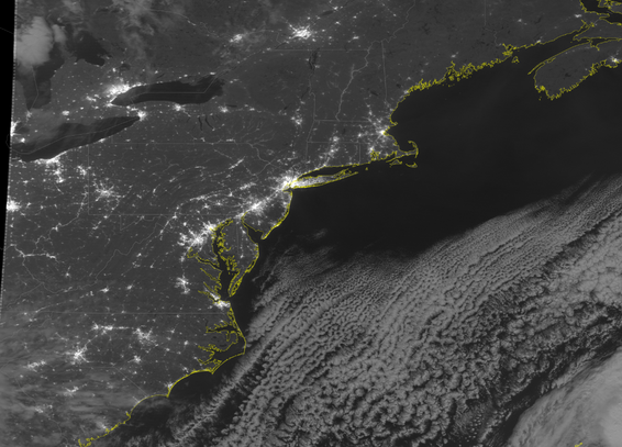
778 followers · 2788 posts · Server mindly.socialBright city lights, moonlight, and few clouds make for a very photogenic NOAA-20 VIIRS nighttime pass over the US East Coast tonight #RemoteSensing #Weather
Raúl Nanclares · @rnanclares
327 followers · 1689 posts · Server fosstodon.orgWorldPopProject · @WorldPopProject
247 followers · 128 posts · Server mapstodon.space🚨 WorldPop analysis published together with #UNFPA #LACRO Università degli Studi di Milano #unimib and the German Aerospace Center #DLR on the production of high-resolution gridded population datasets for 40 Latin America/Caribbean countries using official statistics: https://lnkd.in/en5FmkxQ
#unfpa #lacro #unimib #dlr #census #GIS #demography #remotesensing #stats #statistics
GregCocks · @GregCocks
612 followers · 555 posts · Server techhub.socialASPRS Approves Edition 2 of the ASPRS Positional Accuracy Standards for Digital Geospatial Data
--
https://www.asprs.org/revisions-to-the-asprs-positional-accuracy-standards-for-geospatial-data-2023 <-- shared technical article
--
https://publicdocuments.asprs.org/PositionalAccuracyStd-Ed2-V1 <-- download the current ASPRS current document
--
#GIS #spatial #mapping #gischat #ASPRS #precision #accuracy #standards #data #spatialdata #PositionalAccuracyStandards #survey #surveying #workinggroup #confidencelevel #metrics #measurement #checkpoints #groundcontrol #VWA #remotesensing #LiDAR #3dmapping #UAS #photogrammetry #geomorphometry
#gis #spatial #mapping #gischat #asprs #precision #accuracy #Standards #data #spatialdata #positionalaccuracystandards #survey #surveying #workinggroup #confidencelevel #metrics #measurement #checkpoints #groundcontrol #vwa #remotesensing #lidar #3dmapping #uas #photogrammetry #geomorphometry
Martin Rutzinger · @mrutzinger
124 followers · 70 posts · Server techhub.socialUAV-borne GPR for Snowpack Investigations #remotesensing #radar #avalanches #naturalhazards
#remotesensing #radar #avalanches #NaturalHazards
Wojciech Jarosz · @wjarosz
577 followers · 373 posts · Server mathstodon.xyzI'm proud to congratulate Kate Salesin for being the #FINESST #PhDStudent at #Dartmouth! I'm super excited for the work she is doing in bridging the fields of #RemoteSensing and #ComputerGraphics, along with our collaborators at #NASA Goddard.
Read more about her project here:
https://web.cs.dartmouth.edu/news/2023/08/computer-science-graduate-student-wins-nasa-grant
#awards #research #grants #academicchatter #nasa #computergraphics #remotesensing #dartmouth #phdstudent #finesst
Sam F · @samfranklin
8 followers · 4 posts · Server mapstodon.spaceWe are just a week or so out from #foss4guk2023 1-day conference (7 Sept). It's a friendly distributed community led event for geospatial/software types, registrations are still open. Check out https://uk.osgeo.org/foss4guklocal2023/ #gischat #remotesensing #geospatial @osgeouk
#foss4guk2023 #gischat #remotesensing #geospatial


