
NakjiKiss3 · @NakjiKiss3
77 followers · 1295 posts · Server mastodon.akhepcat.comA collection of interactive sea level rise risk maps for the whole world (not just the USA). Sometimes slow-loading (depending on your connection) but eye-opening.
#climatechange #sealevelrisemaps

Conspiracy of Cartographers · @ConspiracyOfCartographers
223 followers · 34 posts · Server mastodon.social
Petrofuture map of California.
This shows an old Shell Oil map base with 66m sea level rise...the highest level of sea rise estimated by the IPCC.
1956 map from @david_rumsey_maps
#sanfrancisco #oaklandca #sandiego #CaliforniaFloods #MapArt #mapsAsArt #vintagemaps #retrofuture #petrofuture #climatearson #solarpunk #sealevelrise #sealevelrisemaps #climatechange #climatechangemaps #maps #cartography #speculativecartography #speculativemaps #clifi #climateart #conspiracyofcartographers
#sanfrancisco #oaklandca #sandiego #californiafloods #mapart #mapsasart #vintagemaps #retrofuture #petrofuture #climatearson #solarpunk #sealevelrise #sealevelrisemaps #climatechange #climatechangemaps #maps #cartography #speculativecartography #speculativemaps #clifi #climateart #conspiracyofcartographers
Conspiracy of Cartographers · @ConspiracyOfCartographers
220 followers · 33 posts · Server mastodon.social
~100 mi inland, #Sacramento is basically at sea level. Short-term, flooding here could come from above. Long term, from below...
Part of the #Retrofuture series, here's a 1892 #USGS quad with 66m sea rise, the highest predicted by the #IPCC if all ice caps melted.
#sacramentoValley #centralValley #folsom #SierraNevada #CaliforniaRain #CaliforniaFloods #mapArt #climateArson #solarPunk #seaLevelRise #seaLevelRiseMaps #climateChange #maps #cartography #clifi #climateArt #conspiracyOfCartographers
#sacramento #retrofuture #usgs #ipcc #SacramentoValley #centralvalley #folsom #sierranevada #californiarain #californiafloods #mapart #climatearson #solarpunk #sealevelrise #sealevelrisemaps #climatechange #maps #cartography #clifi #climateart #conspiracyofcartographers
Conspiracy of Cartographers · @ConspiracyOfCartographers
217 followers · 32 posts · Server mastodon.social
A different kind of flooding in California...
Part of the Retrofuture series, here's a 1902 USGS Napa Valley quad with 66m sea level rise, the highest predicted by the #IPCC if all ice caps melted.
#Napa #napaValley #StHelenaCA #Yountville #SierraNevada #CaliforniaRain #CaliforniaFloods #sanFrancisco #MarinCounty #NapaCounty #OaklandCA #mapArt #climateArson #solarPunk #retrofuture #seaLevelRise #seaLevelRiseMaps #climateChange #maps #cartography #clifi #climateArt #conspiracyOfCartographers
#ipcc #napa #napavalley #sthelenaca #yountville #sierranevada #californiarain #californiafloods #sanfrancisco #marincounty #napacounty #oaklandca #mapart #climatearson #solarpunk #retrofuture #sealevelrise #sealevelrisemaps #climatechange #maps #cartography #clifi #climateart #conspiracyofcartographers
Conspiracy of Cartographers · @ConspiracyOfCartographers
210 followers · 30 posts · Server mastodon.social
Not to be outdone by the previous map to the east, this is the 1952 USGS quad of Goleta.
A different kind of flooding...with 66m of sea level rise—if all the world’s ice caps melted.
#santabarbara #montecito #ucsb #pch #the101 #goleta #santaynezmountains #vintagemaps #oldmaps #retrofuture #steampunk #solarpunk #shadedrelief #searisemaps #sealevelrise #sealevelrisemaps #climatechange #climatechangemaps #maps #cartography #speculativecartography #conspiracyofcartographers
#santabarbara #montecito #ucsb #pch #the101 #goleta #santaynezmountains #vintagemaps #oldmaps #retrofuture #steampunk #solarpunk #shadedrelief #searisemaps #sealevelrise #sealevelrisemaps #climatechange #climatechangemaps #maps #cartography #speculativecartography #conspiracyofcartographers
Conspiracy of Cartographers · @ConspiracyOfCartographers
191 followers · 29 posts · Server mastodon.social
A different kind of flooding...Santa Barbara retrofuture…this is a USGS quad from 1952, with 218’ of sea level rise—if all the world’s ice caps melted.
#santabarbara #montecito #ucsb #pch #the101 #lamesa #santaynezmountains #vintagemaps #coolmaps #oldmaps #retrofuture #steampunk #3dterrain #shadedrelief
#searise #searisemaps #sealevelrise #sealevelrisemaps #climatechange #climatechangemaps #maps #cartography #speculativecartography #speculativemaps #conspiracyofcartographers
#santabarbara #montecito #ucsb #pch #the101 #lamesa #santaynezmountains #vintagemaps #coolmaps #oldmaps #retrofuture #steampunk #3dterrain #shadedrelief #searise #searisemaps #sealevelrise #sealevelrisemaps #climatechange #climatechangemaps #maps #cartography #speculativecartography #speculativemaps #conspiracyofcartographers
Conspiracy of Cartographers · @ConspiracyOfCartographers
190 followers · 28 posts · Server mastodon.social
A different kind of flooding in California...Here's the Bay Area and Central Valley with 66m of sea level rise, the highest predicted by the #IPCC if all the ice caps melted.
#SacramentoCA #centralValley #SantaCruzCA #CapitolaCA #SierraNevada #CaliforniaRain #CaliforniaFloods #sanFrancisco #MarinCounty #NapaCounty #OaklandCA #mapart #climatearson #solarpunk #oilandgasindustry #sealevelrise #sealevelrisemaps #climatechange #maps #cartography #clifi #climateart #conspiracyofcartographers
#ipcc #sacramentoca #centralvalley #santacruzca #capitolaca #sierranevada #californiarain #californiafloods #sanfrancisco #marincounty #napacounty #oaklandca #mapart #climatearson #solarpunk #oilandgasindustry #sealevelrise #sealevelrisemaps #climatechange #maps #cartography #clifi #climateart #conspiracyofcartographers
Conspiracy of Cartographers · @ConspiracyOfCartographers
127 followers · 25 posts · Server mastodon.social
Retrofuture California...66m sea level rise on a vintage 1879 map.
You can buy most of the maps I post ...
https://conspiracyofcartographers.com/retrofuture-gallery/#uael-gallery-17
#LosAngeles #Sacramento #sanFrancisco #SanDiego #coachella #santaBarbara #mapart #retrofuture #steampunk #climatearson #solarpunk #oilandgasindustry #sealevelrise #sealevelrisemaps #climatechange #maps #cartography #clifi #climateart #conspiracyofcartographers
#losangeles #sacramento #sanfrancisco #sandiego #coachella #santabarbara #mapart #retrofuture #steampunk #climatearson #solarpunk #oilandgasindustry #sealevelrise #sealevelrisemaps #climatechange #maps #cartography #clifi #climateart #conspiracyofcartographers
Conspiracy of Cartographers · @ConspiracyOfCartographers
119 followers · 20 posts · Server mastodon.social
Los Angeles Retrofuture... 1920s El Monte USGS Quad with 66m of sea level rise.
https://conspiracyofcartographers.com/retrofuture-gallery/
6/6
#losangeles #whittier #whittiernarrows #picorivera #eastlosangeles #eastla #theoc #orangecounty #elmonte #montebello #vintagemaps #coolmaps #oldmaps #retrofuture #bladerunner2049 #steampunk #3dterrain #shadedrelief
#searise #searisemaps #sealevelrise #sealevelrisemaps #climatechange #climatechangemaps #maps #cartography #speculativecartography #speculativemaps #conspiracyofcartographers
#losangeles #whittier #whittiernarrows #picorivera #eastlosangeles #eastla #theoc #orangecounty #elmonte #montebello #vintagemaps #coolmaps #oldmaps #retrofuture #bladerunner2049 #steampunk #3dterrain #shadedrelief #searise #searisemaps #sealevelrise #sealevelrisemaps #climatechange #climatechangemaps #maps #cartography #speculativecartography #speculativemaps #conspiracyofcartographers
Conspiracy of Cartographers · @ConspiracyOfCartographers
118 followers · 19 posts · Server mastodon.social
Los Angeles Retrofuture... 1920s Alhambra USGS Quad with 66m of sea level rise.
https://conspiracyofcartographers.com/retrofuture-gallery/
5/6
#losangeles #eastlosangeles #eastla #eastlos #alhambracalifornia #sangabriel #theoc #orangecounty #southerncalifornia #california #montebello #vintagemaps #oldmaps #retrofuture #steampunk #3dterrain #shadedrelief
#searise #searisemaps #sealevelrise #sealevelrisemaps #climatechange #climatechangemaps #maps #cartography #speculativecartography #speculativemaps #conspiracyofcartographers
#losangeles #eastlosangeles #eastla #eastlos #alhambracalifornia #sangabriel #theoc #orangecounty #southerncalifornia #california #montebello #vintagemaps #oldmaps #retrofuture #steampunk #3dterrain #shadedrelief #searise #searisemaps #sealevelrise #sealevelrisemaps #climatechange #climatechangemaps #maps #cartography #speculativecartography #speculativemaps #conspiracyofcartographers
Conspiracy of Cartographers · @ConspiracyOfCartographers
118 followers · 18 posts · Server mastodon.social
Los Angeles Retrofuture... 1920s Los Angeles USGS Quad with 66m of sea level rise.
https://conspiracyofcartographers.com/retrofuture-gallery/
4/6
#losangeles #eastla #boyleheights #dtla #echopark #silverlake #westlake #losfeliz #koreatown #usc #vintagemaps #coolmaps #oldmaps #retrofuture #bladerunner2049 #steampunk #3dterrain #shadedrelief
#searise #searisemaps #sealevelrise #sealevelrisemaps #climatechange #climatechangemaps #maps #cartography #speculativecartography #speculativemaps #conspiracyofcartographers
#losangeles #eastla #boyleheights #dtla #echopark #silverlake #westlake #losfeliz #koreatown #usc #vintagemaps #coolmaps #oldmaps #retrofuture #bladerunner2049 #steampunk #3dterrain #shadedrelief #searise #searisemaps #sealevelrise #sealevelrisemaps #climatechange #climatechangemaps #maps #cartography #speculativecartography #speculativemaps #conspiracyofcartographers
Conspiracy of Cartographers · @ConspiracyOfCartographers
118 followers · 17 posts · Server mastodon.social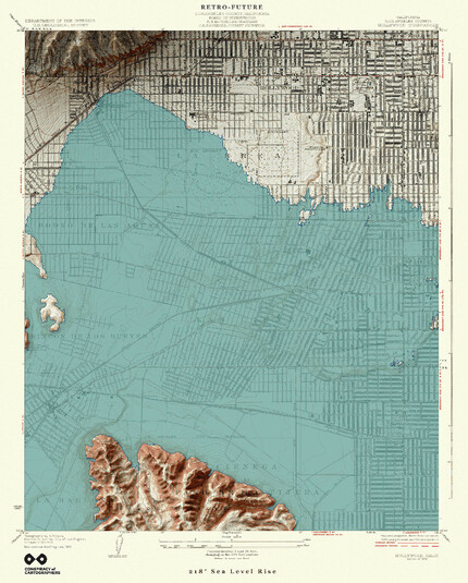
Los Angeles Retrofuture... 1920s Hollywood USGS Quad with 66m of sea level rise.
https://conspiracyofcartographers.com/retrofuture-gallery/
3/6
#losangeles #hollywood #baldwinhills #wilshire #labrea #losfeliz #beverlyhills #vintagemaps #coolmaps #oldmaps #retrofuture #bladerunner2049 #MapArt #3dterrain #shadedrelief
#searise #searisemaps #sealevelrise #sealevelrisemaps #climatechange #climatechangemaps #maps #cartography #speculativecartography #speculativemaps #conspiracyofcartographers
#losangeles #hollywood #baldwinhills #wilshire #labrea #losfeliz #beverlyhills #vintagemaps #coolmaps #oldmaps #retrofuture #bladerunner2049 #mapart #3dterrain #shadedrelief #searise #searisemaps #sealevelrise #sealevelrisemaps #climatechange #climatechangemaps #maps #cartography #speculativecartography #speculativemaps #conspiracyofcartographers