
Key Biscayne Independent · @kbindependent
85 followers · 428 posts · Server newsie.social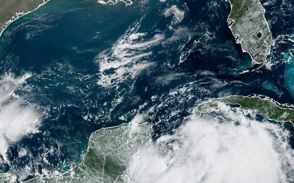
Idalia becomes a tropical storm, aims at Florida :
The greatest threat was to Florida’s west coast, and storm watches may be issued later today. Forecasters said portions of Florida could get 3 to 6 inches of rain.
#ClimateChange #GulfofMexico #Idalia #NationalHurricaneCenter #SeaSurfaceTemperature #TropicalStorm
#Miami #news
https://kbindependent.org/2023/08/27/idalia-becomes-a-tropical-storm-aims-at-florida/
#climatechange #gulfofmexico #idalia #nationalhurricanecenter #seasurfacetemperature #tropicalstorm #miami #News

Ariadne · @ariadne
1061 followers · 767 posts · Server climatejustice.social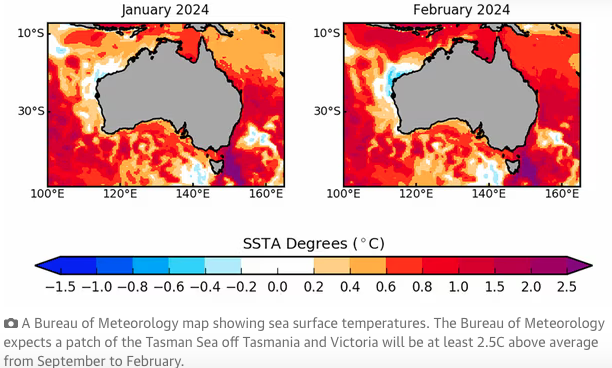
"South-east #Australia #marine #heatwave forecast to be literally off the scale - Patch of Tasman sea expected to warm over spring and summer to temperatures that risk significant losses to sea life
Australia’s south-east could be in for a marine heatwave that is literally off the scale, raising the prospect of significant losses in fishing and aquaculture.
The Bureau of Meteorology has forecast a patch of the Tasman Sea off Tasmania and Victoria could be at least 2.5C above average from September to February, and it could get hotter.
Oceanographer Grant Smith said the colour-coded scale the bureau uses to map forecast sea surface temperature anomalies stops at 2.5C. “We didn’t account for anomalies that high when we developed this ... it could be 3C, it could be 3.5C, but we can’t see how high it goes,” he said.
...
South-eastern Australia is a known climate change hotspot with its waters warming about four times faster than the global average."
#TasmanSea #MarineHeatwave #OceanWarming #CoralReefs #CoralReef #SeaLife #ClimateCrisis #ClimateEmergency #Climate #Klima #Klimakrise #SST #SeaSurfaceTemperature #Oceans #Ocean #ClimateDiary #Tasmania
#australia #marine #heatwave #tasmansea #marineheatwave #OceanWarming #coralreefs #coralreef #sealife #ClimateCrisis #ClimateEmergency #climate #Klima #KlimaKrise #SST #seasurfacetemperature #oceans #ocean #ClimateDiary #tasmania
Ariadne · @ariadne
1048 followers · 695 posts · Server climatejustice.social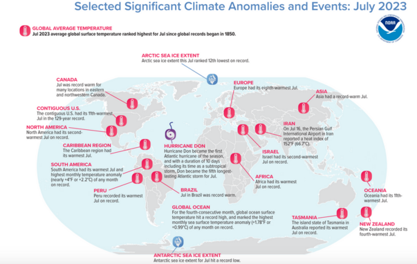
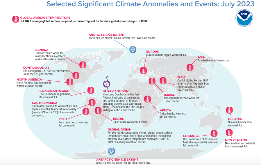
"Record shattering: #Earth had its #hottest #July in 174 years -
Global sea surface temperature hit record high for 4th-consecutive month
Earth just roasted under its hottest July on record, according to scientists from NOAA’s National Centers for Environmental Information (NCEI). For the fourth-consecutive month, the global ocean surface temperature also hit a record high.
#Climate by the numbers - July 2023 - The average global surface temperature in July was 2.02 degrees F (1.12 degrees C) above average, ranking it as the warmest July in NOAA’s 174-year record. Because July is the globe’s warmest month of the year from a climatological perspective, July 2023 was also likely Earth’s warmest month on record.
July 2023 was the first time an average July temperature exceeded 1.8 degrees F (1.0 degree C) above the long-term average. Also of note, last month was 0.36 of a degree F (0.20 of a degree C) warmer than the previous July record from 2021. July 2023 marked the 47th-consecutive July and the 533rd-consecutive month with temperatures above the 20th-century average.
For the fourth-consecutive month, the global ocean surface temperature hit a record high as El Niño conditions that emerged in June continued into July. Globally, July 2023 set a record for the highest monthly sea surface temperature anomaly — which indicates how much warmer or cooler temperatures are from the long-term average — of any month in NOAA’s climate record, with an anomaly of 1.78 degrees F or 0.99 of a degree C. On July 13, NOAA’s Climate Prediction Center issued a statement announcing a greater than 95% chance that El Nino will continue through winter in the Northern Hemisphere.
https://www.noaa.gov/news/record-shattering-earth-had-its-hottest-july-in-174-years
#ClimateEmergency #ClimateCrisis #Klima #Klimakrise #Climate #ClimateDiary #SurfaceTemperature #SeaSurfaceTemperature #SST #Oceans #Ocean #OceanWarming #GlobalWarming
#earth #hottest #july #climate #ClimateEmergency #ClimateCrisis #Klima #KlimaKrise #ClimateDiary #surfacetemperature #seasurfacetemperature #SST #oceans #ocean #OceanWarming #globalwarming
Key Biscayne Independent · @kbindependent
82 followers · 391 posts · Server newsie.socialHeat warning: Today could feel like hottest ever :
“In terms of what we can issue, we are at the highest level,” Pine said in a year that has shattered records all over Florida."
#BrianMcNoldy #CameronPine #ExcessiveHeatWarning #feelslike #heatindex #NationalWeatherService #SeaSurfaceTemperature
#Miami #news
https://kbindependent.org/2023/08/08/heat-warning-today-could-feel-like-hottest-ever/
#brianmcnoldy #cameronpine #excessiveheatwarning #feelslike #heatindex #nationalweatherservice #seasurfacetemperature #miami #News
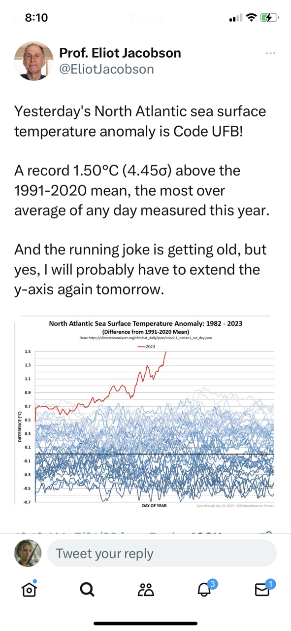
Ariadne · @ariadne
962 followers · 473 posts · Server climatejustice.social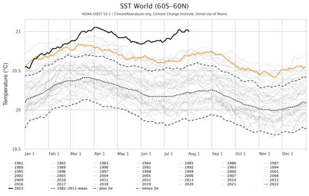
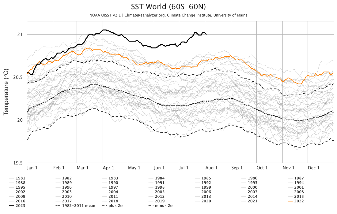
Here is a daily updated plot of Sea Surface Temperature (SST) from 1981 to the present day. It is a frightening graph, and is predicted to only worsen.
You can go to https://climatereanalyzer.org/clim/sst_daily/ for the latest updates.
#SeaSurfaceTemperature #SST #Oceans #OceanTemperature #GlobalWarming #Climate #ClimateCrisis #ClimateEmergency #Klima #Klimakrise
#seasurfacetemperature #SST #oceans #OceanTemperature #globalwarming #climate #ClimateCrisis #ClimateEmergency #Klima #KlimaKrise

Sam McClatchie · @Huia_fishocean
394 followers · 163 posts · Server fediscience.org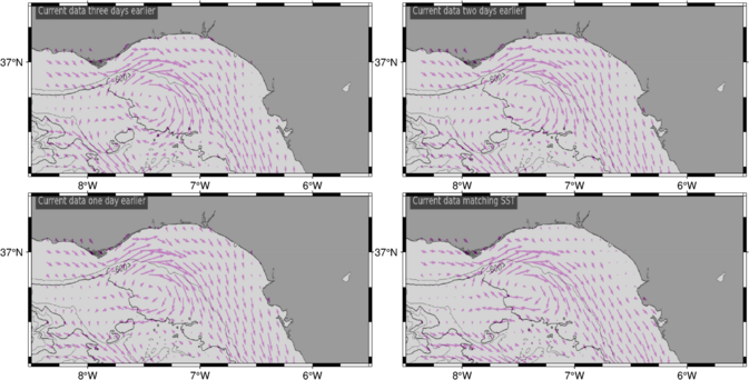
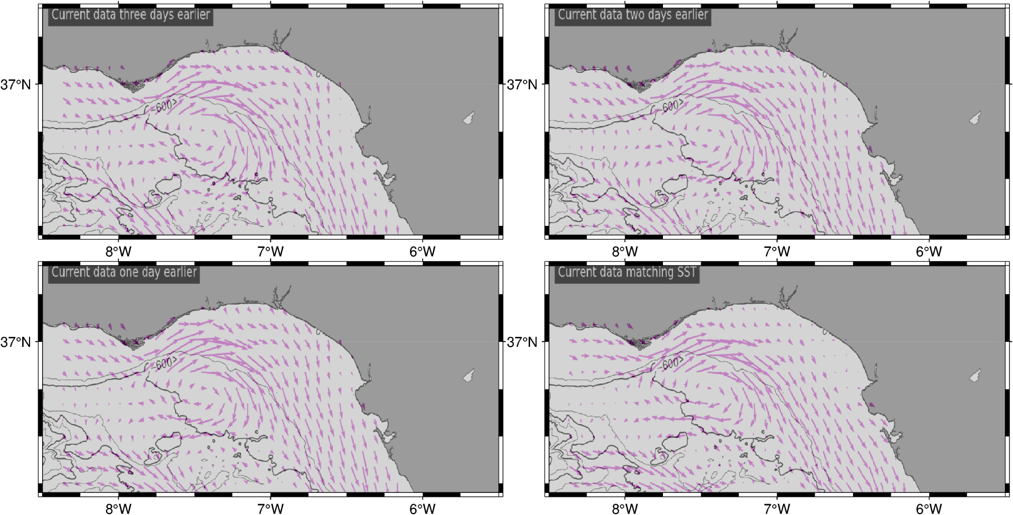
Producing fishing maps for recreational game fishers yields some fascinating patterns in SST, geostrophic currents and chlorophyll. Here is a hot spot in SST associated with an cyclonic (anticlockwise) eddy of a counter-rotating eddy pair in the Bay of Cadiz south of Portugal, where they fish for tunas. Almost no chlorophyll associated with the hotspot.
#fisheries #ocean #oceanography # tuna #GameFishing #SeaSurfaceTemperature
#seasurfacetemperature #gamefishing #oceanography #ocean #fisheries
Key Biscayne Independent · @kbindependent
81 followers · 367 posts · Server newsie.social
Florida waters hit hot tub levels :
"We've never seen a record-breaking event like this before," meteorologist Jeff Masters said.
#BrianMcNoldy #EvergladesNationalPark #FloridaKeys #JeffMasters #ManateeBay #RosenstielSchool #SeaSurfaceTemperature #YaleClimateConnections
#Miami #news
https://kbindependent.org/2023/07/26/florida-waters-hit-hot-tub-levels/
#brianmcnoldy #evergladesnationalpark #floridakeys #jeffmasters #manateebay #rosenstielschool #seasurfacetemperature #yaleclimateconnections #miami #News

Buffy the Psych Prof · @DrPsyBuffy
1824 followers · 2123 posts · Server mstdn.social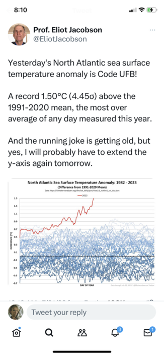

Till Kuhlbrodt · @tillku
246 followers · 856 posts · Server mastodon.sdf.orgAn analysis of the current extremely high #seasurfacetemperature in the North #Atlantic #Ocean, by the EU's Copernicus #Climate Change Service
#seasurfacetemperature #atlantic #ocean #climate

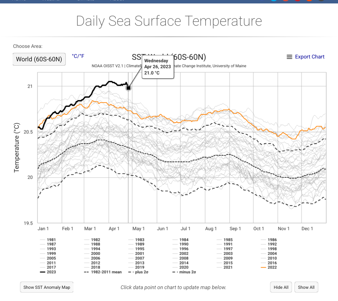
Kent Pitman · @kentpitman
286 followers · 500 posts · Server climatejustice.socialThe wording is defensible, but still confusing. Just to clarify: 66 years old, carrying mail 40 years is what the 40 years seems to imply.
This doesn't make it less bad, but I just wanted to make it clear, since there's a little difference between someone who's 66 keeling over from heat and someone 40 doing so.
The way things are going, you'll want to wait until next week for the 40-year-olds to be falling. (Only half-kidding. These are scary times. This temperature stuff seems untethered from anything we can compare to in the historical record.)
https://climatereanalyzer.org/clim/sst_daily/
And yes, this is anecdotal and not statistical. That's offered mostly just to make the stats seem less abstract. But the statistics say we're way outside the norms. Here's an interesting way to view that which came up over at the bird site recently:
https://twitter.com/BMcNoldy/status/1668706139184193537?s=20
#ClimateHeat #Climate #Texas #Heat #Ocean #SeaSurfaceTemperature #Temperature
#climateheat #climate #texas #heat #ocean #seasurfacetemperature #temperature
Key Biscayne Independent · @kbindependent
70 followers · 297 posts · Server newsie.social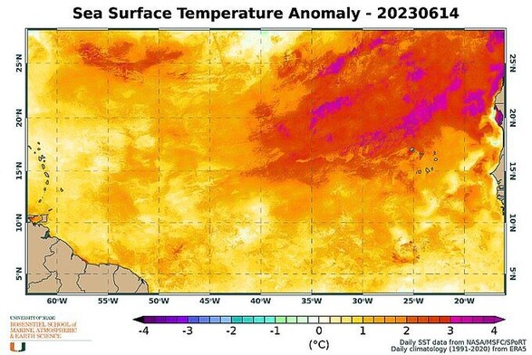
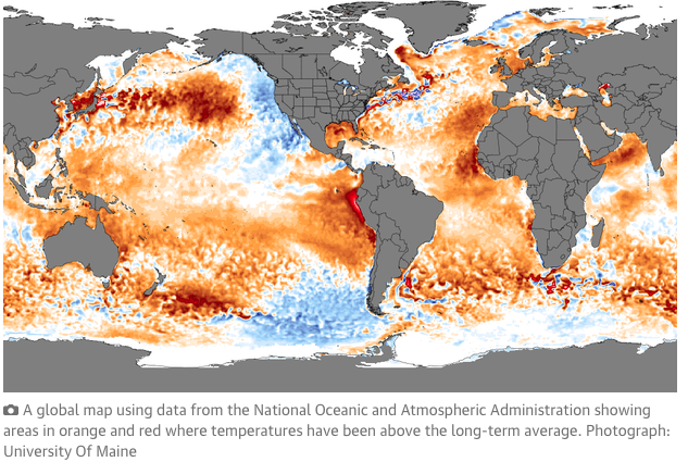
Much of the ocean is getting really hot. No one knows why. :
On social media, instead of trading selfies, scientists are posting screenshots of ocean heat maps and wonky-looking charts and tables of thermal history.
#AtlanticOcean #BrianMcNoldy #Caribbean #ClimateChange #current #ElNiño #GlobalWarming #Hurricane #NickShay #RosenstielSchool #SeaSurfaceTemperature #SST #TropicalStorm
#Miami #news
https://kbindependent.org/2023/06/18/much-of-the-ocean-is-getting-really-hot-no-one-knows-why/
#atlanticocean #brianmcnoldy #caribbean #climatechange #current #elnino #globalwarming #hurricane #nickshay #rosenstielschool #seasurfacetemperature #sst #tropicalstorm #miami #News

Stefan Kruijer 🇪🇺 · @skruij
32 followers · 146 posts · Server digitalcourage.social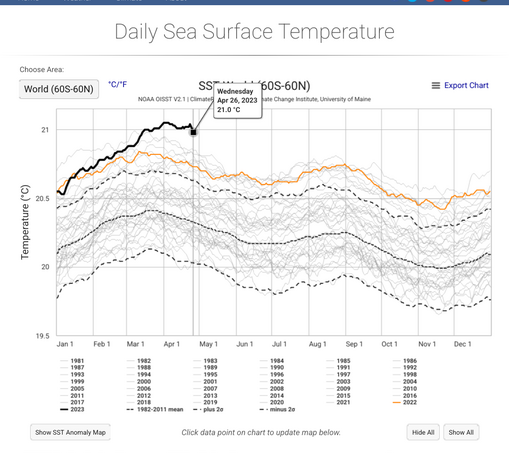
Während in Deutschland Ablenkungsdebaten geführt werden, passiert in den Weltmeeren Besorgniseregendes: die Oberflächentemperatur steigt in unbekannte Höhen
#seasurfacetemperature #klimakrise

Ariadne · @ariadne
879 followers · 175 posts · Server kolektiva.social
"Record #ocean temperatures put #Earth in ‘uncharted territory’, say scientists
"‘Unprecedented’ warming indicates #ClimateCrisis is taking place before our eyes, experts say - Temperatures in the world’s oceans have broken fresh records, testing new highs for more than a month in an “unprecedented” run that has led to scientists stating the Earth has reached “uncharted territory” in the climate crisis.
The rapid acceleration of ocean temperatures in the last month is an #anomaly that scientists have yet to explain. Data collated by the US National Oceanic and Atmospheric Administration (NOAA), known as the Optimum Interpolation Sea Surface Temperature (OISST) series, gathered by satellites and buoys, has shown temperatures higher than in any previous year, in a series stretching back to 1981, continuously over the past 42 days.
The world is thought to be on the brink of an El Niño weather event this year – a cyclical weather system in the Pacific, that has a warming impact globally. But the El Niño system is yet to develop, so this oscillation cannot explain the recent rapid heating, at a time of year when ocean temperatures are normally declining from their annual March and April peaks."
#GlobalWarming #Climate #Klima #KlimaKrise #OceanWarming #SeaSurfaceTemperature #SST #NOAA #ElNino
#ocean #earth #ClimateCrisis #anomaly #globalwarming #climate #klima #klimakrise #oceanwarming #seasurfacetemperature #sst #noaa #elnino
Ariadne · @ariadne
781 followers · 195 posts · Server kolektiva.social
"‘Headed off the charts’: world’s #ocean surface temperature hits record high - Scientists warn of more marine #heatwaves, leading to increased risk of extreme weather.
The temperature of the world’s ocean surface has hit an all-time high since satellite records began, leading to marine heatwaves around the globe, according to US government data.
Climate scientists said preliminary data from the National Oceanic and Atmospheric Administration (Noaa) showed the average temperature at the ocean’s surface has been at 21.1C since the start of April – beating the previous high of 21C set in 2016.
The current trajectory looks like it’s headed off the charts, smashing previous records,” said Prof Matthew England, a climate scientist at the University of New South Wales."
#ClimateCrisis #Climate #Klimakrise #Klima #SST #SeaSurfaceTemperature #OceanSurfaceTemperature #GlobalHeating #GlobalWarming
#ocean #heatwaves #ClimateCrisis #climate #klimakrise #klima #sst #seasurfacetemperature #oceansurfacetemperature #globalheating #globalwarming

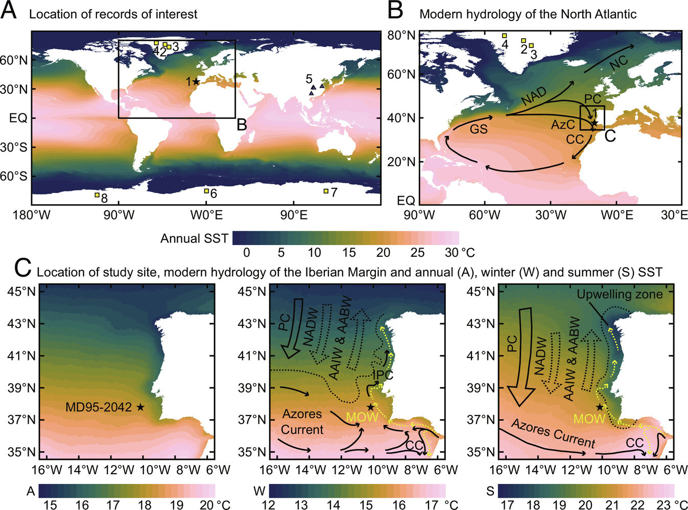
Nina Davtian · @nina_davtian
381 followers · 565 posts · Server mastodon.world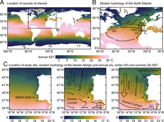
New first-authored #scientific #publication in @PNASNews with Edouard Bard (Collège de France and CEREGE)!
We revisit the #thermal bipolar seesaw using #PaleoTemperature records from the #IberianMargin!
#Science #Paper #FirstAuthor
#PaleoClimate #PaleoClimates
#ClimateChanges #AbruptClimateChange
#SeaSurfaceTemperature #SST
#ClimateProxies #GDGTs #RIOH #Alkenones #UK37
#NorthAtlantic #AtlanticOcean #Atlantic #Ocean
#AtlanticMeridionalOverturningCirculation #AMOC
https://doi.org/10.1073/pnas.2209558120 (1/20)
#scientific #publication #Thermal #paleotemperature #iberianmargin #science #paper #firstauthor #paleoclimate #Paleoclimates #climatechanges #abruptclimatechange #seasurfacetemperature #sst #climateproxies #gdgts #rioh #alkenones #uk37 #northatlantic #atlanticocean #atlantic #ocean #atlanticmeridionaloverturningcirculation #amoc

GregCocks · @GregCocks
173 followers · 193 posts · Server techhub.social
A New Interactive [Mapping] Research Tool For The Antarctic Sea-Ice Zone [Nilas]
--
https://phys.org/news/2023-02-interactive-tool-antarctic-sea-ice-zone.html <-- shared article
--
https://nilas.org/#1/-90/0 <-- NILAS software home page
--
“The Southern Ocean Mapping Platform - Nilas is a mapping tool (beta) which displays multiple layers of physical and biogeochemical variables. The data displayed are primarily derived from remotely sense products and updated as source data becomes available. The Australian Antarctic Division developed this tool to cover the Antarctic sea-ice zone and to support their research and operational activities…"
#GIS #spatial #mapping #Nilas #marine #data #research #planning #science #Antarctic #seaice #geospatial #ice #climatechange #water #hydrology #hydrospatial #SouthernOceanMappingPlatform #mapportal #opendata #SouthernOcean #spatiotemporal #historicdata #climateresearch #climate #chlorophyll #phytoplankton #seasurfacetemperature #Antarctica #ecosystem #spatialanalysis
#gis #spatial #mapping #nilas #marine #data #research #planning #science #antarctic #seaice #geospatial #ice #climatechange #water #hydrology #hydrospatial #southernoceanmappingplatform #mapportal #opendata #southernocean #spatiotemporal #historicdata #Climateresearch #climate #chlorophyll #phytoplankton #seasurfacetemperature #antarctica #ecosystem #spatialanalysis
Sam McClatchie · @Huia_fishocean
375 followers · 135 posts · Server fediscience.org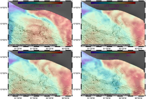
Moving on to producing fishing maps for U.S. and Central American game fishing regions now (https://www.fishingmaps.info). This one is for Puerto Quetzal, Guatemala. There's an impressive cross-shelf canyon where they fish for Pacific Sailfish at this time of year. These maps show the most recent 4 days of SST overlaid on bathymetry.
#fisheries #oceanography #GameFishing #SST #SeaSurfaceTemperature #maps
#maps #seasurfacetemperature #SST #gamefishing #oceanography #fisheries
Sam McClatchie · @Huia_fishocean
373 followers · 133 posts · Server fediscience.org
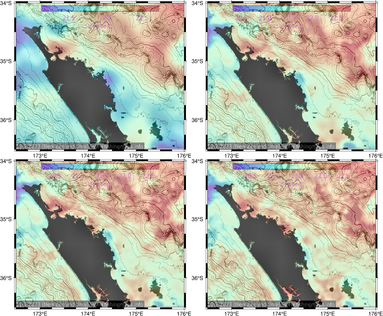
Cooling of #SeaSurfaceTemperature around Northland, New Zealand with the passage of #cyclone Gabriel. See the dates on the bottom left of each map. Maps at https://www.fishingmaps.info
#oceanography #fisheries #SST #RemoteSensing #satellite #maps #visualization
#visualization #maps #satellite #RemoteSensing #SST #fisheries #oceanography #cyclone #seasurfacetemperature
Sam McClatchie · @Huia_fishocean
373 followers · 133 posts · Server fediscience.org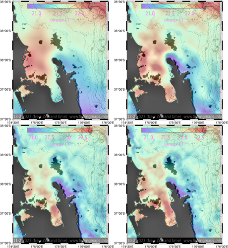
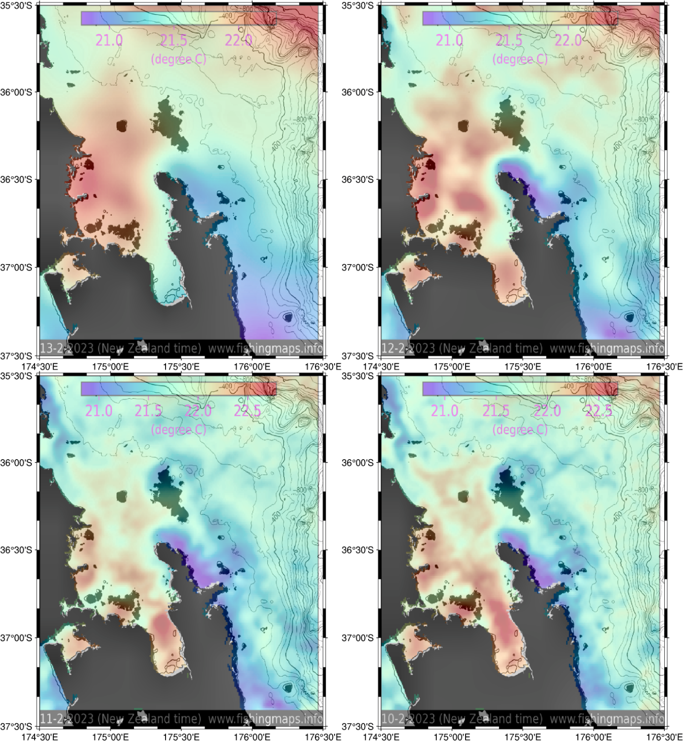
Here's a nice example of how the high winds from #cyclone Gabriel are smoothing out the #SeaSurfaceTemperature structure around the Coromandel Peninsumala, New Zealand (see the dates in the bottom left corner of each map). Maps by https://www.fishingmaps.info
#oceanography #fisheries #SST #RemoteSensing #satellite #maps #visualization
#visualization #maps #satellite #RemoteSensing #SST #fisheries #oceanography #seasurfacetemperature #cyclone
Sam McClatchie · @Huia_fishocean
372 followers · 133 posts · Server fediscience.orgHere's a nice example of how the high winds from #cyclone Gabriel are smoothing out the #SeaSurfaceTemperature structure around the Coromandel Peninsula, New Zealand (see the dates in the bottom left corner of each map). Maps by www.fishingmaps.info
#oceanography #fisheries #SST #RemoteSensing #satellite #maps #visualization
#visualization #maps #satellite #RemoteSensing #SST #fisheries #oceanography #seasurfacetemperature #cyclone