Prof. Simon Carn · @simoncarn
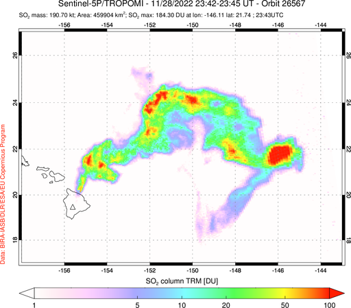
15 followers · 1 posts · Server mastodon.social#Sentinel5P #TROPOMI data for the #MaunaLoa #eruption showing ~0.2 Tg SO₂ on Nov 28. SO₂ furthest east is at higher altitude than the plume nearer the #volcano. For reference, we estimate that the 1984 Mauna Loa eruption emitted ~1.2 Tg SO₂. #MaunaLoaEruption @CopernicusEU
#sentinel5p #tropomi #maunaloa #eruption #volcano #maunaloaeruption
Proletarian Rage · @prolrage
716 followers · 26248 posts · Server todon.nlRT @PlatformAdam@twitter.com
#Turkey and #Greece keep burning! #Wildfires emissions can be clearly seen from space by #Copernicus #Sentinel5p. Here the impressive aerosol index image of today August 5.#Turkeyisburning #greeceisburning #AirQuality #climateEmergency @WMO@twitter.com @asteris@twitter.com @GreekAnalyst@twitter.com @WeDontHaveTime@twitter.com
#ClimateEmergency #airquality #greeceisburning #TurkeyIsBurning #sentinel5p #copernicus #wildfires #greece #turkey
Josef Davies-Coates · @jdaviescoates
335 followers · 5709 posts · Server social.coopRT @esa@twitter.com
New data from @CopernicusEU@twitter.com #Sentinel5P reveal decline of air pollution, specifically NO2 emissions, over Italy. This reduction is particularly visible in northern Italy which coincides with its nationwide lockdown to prevent spread of the #coronavirus 👉
http://www.esa.int/ESA_Multimedia/Videos/2020/03/Coronavirus_nitrogen_dioxide_emissions_drop_over_Italy
Patrick Weber 🌍🇪🇺🇱🇺 · @Petzlux
48 followers · 2975 posts · Server mastodon.xyzRT @CopernicusEU@twitter.com
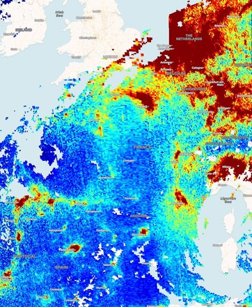
The power of satellite #OpenData: Nitrogen dioxide (total column) over western Europe as seen on last friday by our #Sentinel5P
No comment...


