
Conspiracy of Cartographers · @ConspiracyOfCartographers
210 followers · 30 posts · Server mastodon.social
Not to be outdone by the previous map to the east, this is the 1952 USGS quad of Goleta.
A different kind of flooding...with 66m of sea level rise—if all the world’s ice caps melted.
#santabarbara #montecito #ucsb #pch #the101 #goleta #santaynezmountains #vintagemaps #oldmaps #retrofuture #steampunk #solarpunk #shadedrelief #searisemaps #sealevelrise #sealevelrisemaps #climatechange #climatechangemaps #maps #cartography #speculativecartography #conspiracyofcartographers
#santabarbara #montecito #ucsb #pch #the101 #goleta #santaynezmountains #vintagemaps #oldmaps #retrofuture #steampunk #solarpunk #shadedrelief #searisemaps #sealevelrise #sealevelrisemaps #climatechange #climatechangemaps #maps #cartography #speculativecartography #conspiracyofcartographers
Conspiracy of Cartographers · @ConspiracyOfCartographers
191 followers · 29 posts · Server mastodon.social
A different kind of flooding...Santa Barbara retrofuture…this is a USGS quad from 1952, with 218’ of sea level rise—if all the world’s ice caps melted.
#santabarbara #montecito #ucsb #pch #the101 #lamesa #santaynezmountains #vintagemaps #coolmaps #oldmaps #retrofuture #steampunk #3dterrain #shadedrelief
#searise #searisemaps #sealevelrise #sealevelrisemaps #climatechange #climatechangemaps #maps #cartography #speculativecartography #speculativemaps #conspiracyofcartographers
#santabarbara #montecito #ucsb #pch #the101 #lamesa #santaynezmountains #vintagemaps #coolmaps #oldmaps #retrofuture #steampunk #3dterrain #shadedrelief #searise #searisemaps #sealevelrise #sealevelrisemaps #climatechange #climatechangemaps #maps #cartography #speculativecartography #speculativemaps #conspiracyofcartographers

Jérémy Garniaux · @jeremy
1295 followers · 732 posts · Server mapstodon.space
It's the second time I use one of the beautiful hand-drawn shaded relief by K. Townsend, accessible at shadedreliefarchive.com (public domain), as a basemap.
This quite simple map illustrates the locations of the archaeological materials studied in the ongoing #WomenSOFar research project. Details (Fr): https://womensofar.hypotheses.org.
The history of this shaded relief is a piece of cartographic history worth the read: http://shadedreliefarchive.com/Europe_townsend.html
#womensofar #archaeology #cartography #shadedrelief
ilanthar · @ilanthar
201 followers · 328 posts · Server mastodon.social
Topography of Sherafel (the south western part of Eingana) is done. A little test before I'm doing the rest of the continent.
I placed Gabon for comparison along the equator.
Les reliefs de Sherafel (la partie Sud-Ouest d'Eingana) sont faits. Petit test avant de m'attaquer au reste du continent.
J'ai mis le Gabon pour donner une idée de taille.
#rpg #map #jdr #carte #worldbuilding #wip #shadedrelief
Conspiracy of Cartographers · @ConspiracyOfCartographers
119 followers · 20 posts · Server mastodon.social
Los Angeles Retrofuture... 1920s El Monte USGS Quad with 66m of sea level rise.
https://conspiracyofcartographers.com/retrofuture-gallery/
6/6
#losangeles #whittier #whittiernarrows #picorivera #eastlosangeles #eastla #theoc #orangecounty #elmonte #montebello #vintagemaps #coolmaps #oldmaps #retrofuture #bladerunner2049 #steampunk #3dterrain #shadedrelief
#searise #searisemaps #sealevelrise #sealevelrisemaps #climatechange #climatechangemaps #maps #cartography #speculativecartography #speculativemaps #conspiracyofcartographers
#losangeles #whittier #whittiernarrows #picorivera #eastlosangeles #eastla #theoc #orangecounty #elmonte #montebello #vintagemaps #coolmaps #oldmaps #retrofuture #bladerunner2049 #steampunk #3dterrain #shadedrelief #searise #searisemaps #sealevelrise #sealevelrisemaps #climatechange #climatechangemaps #maps #cartography #speculativecartography #speculativemaps #conspiracyofcartographers
Conspiracy of Cartographers · @ConspiracyOfCartographers
118 followers · 19 posts · Server mastodon.social
Los Angeles Retrofuture... 1920s Alhambra USGS Quad with 66m of sea level rise.
https://conspiracyofcartographers.com/retrofuture-gallery/
5/6
#losangeles #eastlosangeles #eastla #eastlos #alhambracalifornia #sangabriel #theoc #orangecounty #southerncalifornia #california #montebello #vintagemaps #oldmaps #retrofuture #steampunk #3dterrain #shadedrelief
#searise #searisemaps #sealevelrise #sealevelrisemaps #climatechange #climatechangemaps #maps #cartography #speculativecartography #speculativemaps #conspiracyofcartographers
#losangeles #eastlosangeles #eastla #eastlos #alhambracalifornia #sangabriel #theoc #orangecounty #southerncalifornia #california #montebello #vintagemaps #oldmaps #retrofuture #steampunk #3dterrain #shadedrelief #searise #searisemaps #sealevelrise #sealevelrisemaps #climatechange #climatechangemaps #maps #cartography #speculativecartography #speculativemaps #conspiracyofcartographers
Conspiracy of Cartographers · @ConspiracyOfCartographers
118 followers · 18 posts · Server mastodon.social
Los Angeles Retrofuture... 1920s Los Angeles USGS Quad with 66m of sea level rise.
https://conspiracyofcartographers.com/retrofuture-gallery/
4/6
#losangeles #eastla #boyleheights #dtla #echopark #silverlake #westlake #losfeliz #koreatown #usc #vintagemaps #coolmaps #oldmaps #retrofuture #bladerunner2049 #steampunk #3dterrain #shadedrelief
#searise #searisemaps #sealevelrise #sealevelrisemaps #climatechange #climatechangemaps #maps #cartography #speculativecartography #speculativemaps #conspiracyofcartographers
#losangeles #eastla #boyleheights #dtla #echopark #silverlake #westlake #losfeliz #koreatown #usc #vintagemaps #coolmaps #oldmaps #retrofuture #bladerunner2049 #steampunk #3dterrain #shadedrelief #searise #searisemaps #sealevelrise #sealevelrisemaps #climatechange #climatechangemaps #maps #cartography #speculativecartography #speculativemaps #conspiracyofcartographers
Conspiracy of Cartographers · @ConspiracyOfCartographers
118 followers · 17 posts · Server mastodon.social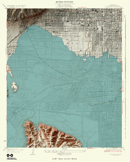
Los Angeles Retrofuture... 1920s Hollywood USGS Quad with 66m of sea level rise.
https://conspiracyofcartographers.com/retrofuture-gallery/
3/6
#losangeles #hollywood #baldwinhills #wilshire #labrea #losfeliz #beverlyhills #vintagemaps #coolmaps #oldmaps #retrofuture #bladerunner2049 #MapArt #3dterrain #shadedrelief
#searise #searisemaps #sealevelrise #sealevelrisemaps #climatechange #climatechangemaps #maps #cartography #speculativecartography #speculativemaps #conspiracyofcartographers
#losangeles #hollywood #baldwinhills #wilshire #labrea #losfeliz #beverlyhills #vintagemaps #coolmaps #oldmaps #retrofuture #bladerunner2049 #mapart #3dterrain #shadedrelief #searise #searisemaps #sealevelrise #sealevelrisemaps #climatechange #climatechangemaps #maps #cartography #speculativecartography #speculativemaps #conspiracyofcartographers

Raf · @Raf
298 followers · 5913 posts · Server mastodon.socialRT @geo_coe@twitter.com
The #IvaloRiver in #Lapland, now with a little #shadedrelief added in for context. Fun to compare the present-day river to past channel locations. Also—bonus dune features at the top of the image. #Finland #dunes #sinuous
#lidar data: https://tiedostopalvelu.maanmittauslaitos.fi/tp/kartta?lang=en
#ivaloriver #lapland #shadedrelief #finland #dunes #sinuous #lidar