Michael Russell · @michaelrussell
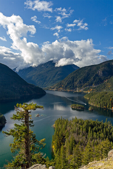
809 followers · 1529 posts · Server mas.toView of Diablo Lake in North Cascades National Park, Washington State, USA. I thought of this photograph today as much of the mountains on the far, right side of the lake have burned in the #SourdoughFire recently. A few more (older) images of the area here:
https://www.mrussellphotography.com/blog/diablo-lake/
For #MountainMonday
#Mountains #NorthCascades #Washington #Landscape #Lakes #LandscapePhotography
#landscapephotography #lakes #landscape #washington #northcascades #mountains #mountainmonday #sourdoughfire
Bud Talbot · @bud_t
475 followers · 1385 posts · Server m.ai6yr.orgCheck out this video of a #KMax doing bucket work out of #DiabloLake on the #SourdoughFire, North Cascades NP. These things are amazing.
#kmax #diablolake #sourdoughfire #Wildfire #wildlandfire
Michael Grass · @mgrass
480 followers · 858 posts · Server mstdn.socialThe smoke forecast on Saturday is not looking good for Whatcom and Skagit counties in Western Washington.
Firesmoke Canada's smoke forecast map:
https://firesmoke.ca/forecasts/current/
WA Ecology's Washington Smoke Blog: https://wasmoke.blogspot.com/2023/08/smoke-impacts-in-central-and-eastern-wa.html?m=1
#WAwx #Wildfires #SourdoughFire #WashingtonState #WildfireSmoke #BellinghamWA
#bellinghamwa #wildfiresmoke #washingtonstate #sourdoughfire #wildfires #wawx
Michael Grass · @mgrass
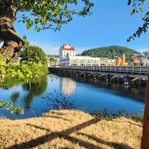
480 followers · 857 posts · Server mstdn.socialAmid blue skies and waterside breezes here in Bellingham, there's some smoke, presumably from the Sourdough Fire in the North Cascades, looming in the distance beyond the foothills.
#BellinghamWA #PNW #WAwx #SourdoughFire #WA #WashingtonState
#washingtonstate #wa #sourdoughfire #wawx #pnw #bellinghamwa
Bud Talbot · @bud_t
464 followers · 1347 posts · Server m.ai6yr.orgWe had to use a boat on Ross lake on the #SourdoughFire to do comms checks in a couple of critical areas. Crews were spiked out on an island and were working around the north side of the fire. We needed to confirm that our command repeater covered those areas, hence the boat ride. It all checked out.
#sourdoughfire #Wildfire #wildlandfire
Bud Talbot · @bud_t
464 followers · 1347 posts · Server m.ai6yr.orgAugust 3 is the day the #SourdoughFire really began to take off. These pictures show the power house below Diablo dam and a drop point and spike camp that we had to move as the fire backed down into Diablo.
#Wildfire #wildlandfire #sourdoughfire
Joseph Elfelt · @mappingsupport
464 followers · 382 posts · Server m.ai6yr.orgAugust 13 morning. #SourdoughFire, Diablo WA.
Infrared flight last night 8:52pm. IR analyst determined 2,586 acres burned.
#RedFlagWarning until Tuesday evening.
Highway 20 is closed.
See “Map tips” and “Legend” links in upper left corner.
#WAwx #WAfire #Wildfire #GIS #Geospatial #Maps #Mapping #Leaflet #ArcGIS #WebMap
Open #GISsurfer map:
https://mappingsupport.com/p2/gissurfer.php?center=48.721829,-121.157741&zoom=13&basemap=USA_basemap&overlay=VIIRS_7_day,MODIS_7_day,State_boundary,USA_roads&fire=WA,Sourdough&data=https://mappingsupport.com/p2/special_maps/disaster/USA_wildland_fire.txt
#sourdoughfire #redflagwarning #wawx #wafire #Wildfire #gis #geospatial #maps #mapping #leaflet #arcgis #webmap #gissurfer
Bud Talbot · @bud_t
464 followers · 1343 posts · Server m.ai6yr.orgOn the morning of August 2, things really began to heat up on the #SourdoughFire. These pictures from Diablo show how the fire was backing down towards the houses and dam infrastructure. This series of dams produces a large percentage of the power for the Seattle Metro area. Lots of value at risk.
#sourdoughfire #Wildfire #wildlandfire
Bud Talbot · @bud_t
464 followers · 1343 posts · Server m.ai6yr.orgHere are a couple of pics of the #SourdoughFire on 8/1, the day before it really blew up.
Bud Talbot · @bud_t
464 followers · 1343 posts · Server m.ai6yr.orgI'm back from the #SourdoughFire in North Cascades National Park in Washington. It was a great assignment, though challenging to get the comms system up and running. Everything was fly-in only which was cool, but added a layer of work.
I'll share more pics later, but here is a start
#sourdoughfire #Wildfire #wildlandfire
Joseph Elfelt · @mappingsupport
431 followers · 327 posts · Server m.ai6yr.orgAugust 5 morning. #SourdoughFire, Diablo WA.
Infrared flight last night 8:17pm. IR analyst determined 1,176 acres burned. However, analyst was not able to fully review area shaded white on the map.
Highway 20 (North Cascades Highway) is currently closed.
Fire is now in North Cascades National Park. This area has not burned in well over 20 years.
#WAwx #WAfire #Wildfire #GIS #Geospatial #Maps #Mapping #Leaflet #ArcGIS #WebMap
Open #GISsurfer map:
https://mappingsupport.com/p2/gissurfer.php?center=48.729307,-121.145382&zoom=13&basemap=USA_basemap&overlay=VIIRS_7_day,MODIS_7_day,State_boundary,USA_roads&fire=WA,Sourdough&data=https://mappingsupport.com/p2/special_maps/disaster/USA_wildland_fire.txt
#sourdoughfire #wawx #wafire #Wildfire #gis #geospatial #maps #mapping #leaflet #arcgis #webmap #gissurfer
Kit · @Scatterseed
268 followers · 506 posts · Server alaskan.socialEvery summer a place I love burns. Every winter a place I love crumbles into the sea. #SourdoughFire #WAFire


