Mark Stosberg · @markstos
399 followers · 1368 posts · Server urbanists.socialI didn’t know R when I wanted to do spatial analysis. So I used some tools I knew: Turf.js & GeoJSON. For a spatial join, I created a hex grid and created attributes for each cell based on how features intersected.
https://mark.stosberg.com/how-to-create-a-heatmap-sidewalk-location-priority/
#SpatialDataScience #mapping #SpatialEquity #geospatial https://masto.machlis.com/@smach/110831326651730942
#SpatialDataScience #mapping #spatialequity #geospatial
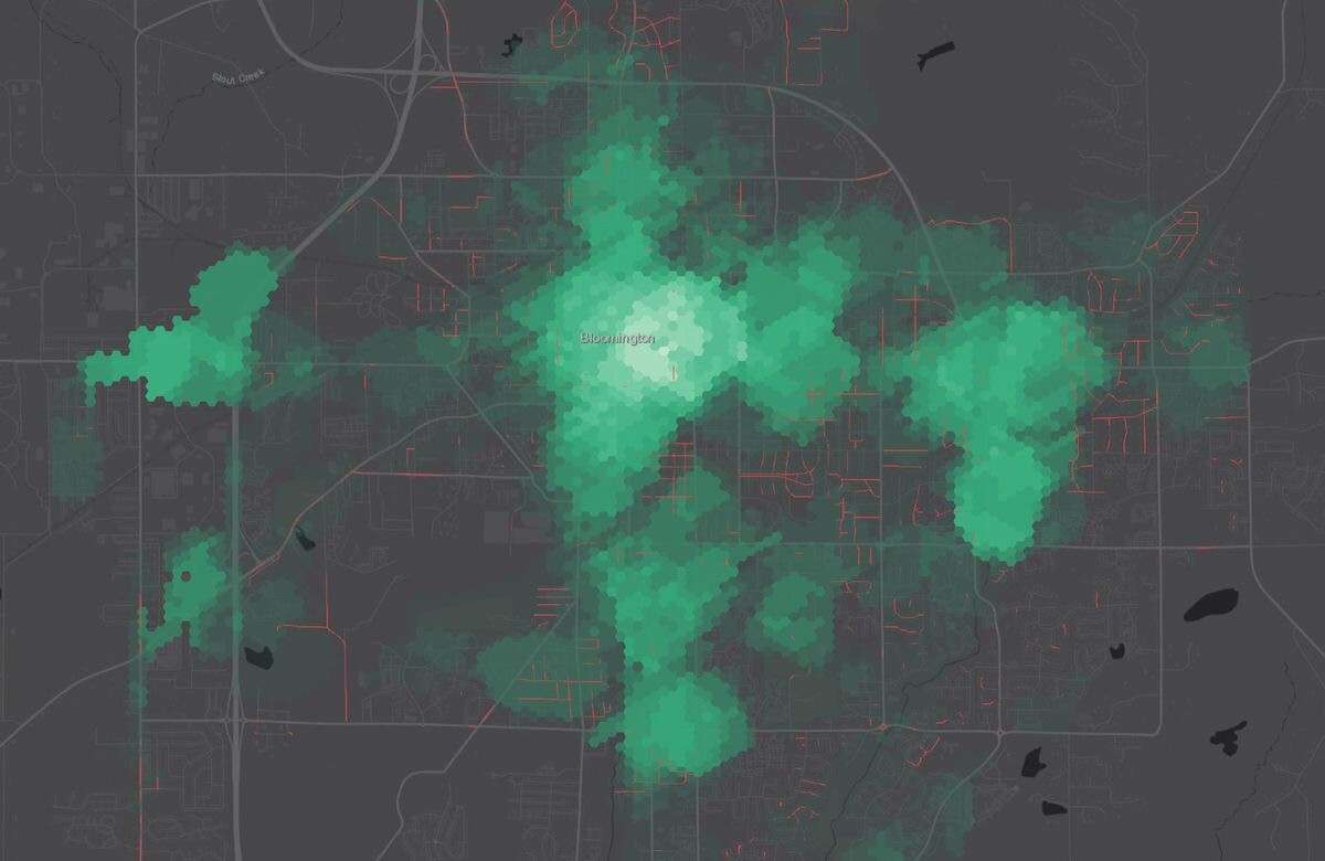
Mark Stosberg · @markstos
291 followers · 689 posts · Server urbanists.social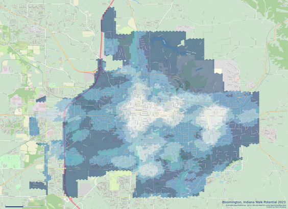
Here's a before/after visualization of the updated Walk Potential Calculations for #BloomingtonIN described above. The one labeled "2023" is before. In broad strokes it is similar. It's noticeable how more area around the university scores higher while more areas on the fringes of the city get the darkest color now. Categories were made with Jenks natural breaks.
#bloomingtonin #UrbanPlanning #spatialequity #gis #mapping
Mark Stosberg · @markstos
272 followers · 639 posts · Server urbanists.socialNew software to calculate walkability and bikeability:
https://github.com/plus-mobilitylab/netascore
#urbanplanning #spatialequity #spatialanalysis #gis #mapping
#UrbanPlanning #spatialequity #spatialanalysis #gis #mapping
Mark Stosberg · @markstos
270 followers · 611 posts · Server urbanists.socialThe first group believes the system will work for them and has time to advocate for it.
The second group may not believe the system will work for them, and maybe it doesn’t or hasn’t, or doesn’t have time or understanding to advocate for themselves.
Both groups deserve good infrastructure.
Mark Stosberg · @markstos
270 followers · 610 posts · Server urbanists.social
I’ve served on a Bike/Ped Commission for years and met neighbors who are good about advocating for better sidewalks in their neighborhoods.
Then I go out and explore the city and find other neighbors have “made the road by walking”. They’ve pounded desire paths into the earth by daily use, yet never showed up to a meeting to complain.
This is why it’s so important that #urbanplanning is based on comprehensive, objective data and not just complaints.
#UrbanPlanning #spatialequity #bloomingtonin

Mark Stosberg · @markstos
262 followers · 554 posts · Server urbanists.socialHow many mayoral campaign donations are local and which neighborhoods are they from?
Great spatial analysis of campaign finance by @chronicallydave
#spatialanalysis #spatialequity #gis #localnews
Mark Stosberg · @markstos
47 followers · 278 posts · Server mastodon.onlineHow to map apartment buildings in #openstreetmap
https://mark.stosberg.com/how-to-map-apartment-buildings-in-openstreetmap-using-id-and-josm/
Useful for #HousingEquity and #SpatialEquity analysis
#mapping #GIS #urbanplanning #spatialequity #housingequity #openstreetmap

Mark Stosberg · @markstos
17 followers · 70 posts · Server masto.es
@sergerey @rsfrankl @geography Congratulations! 🍾 I may have to pick up a copy! I used self-taught spatial analysis to calculate the walk potential of my city and analysis objectively the fairest and most useful locations to fund sidewalks. https://mark.stosberg.com/new-software-to-calculate-walk-potential-for-cities/
#gis #maps #SpatialAnalysis #SpatialEquity
#gis #maps #spatialanalysis #spatialequity

Baukje Rienks · @sabeare
1 followers · 1 posts · Server vis.socialHello , #datavis #dataart , #mapart, #subjectivemapping, #artistsonmastodon, #art, #designresearch, #spatialequity, #creativethinking, #creativemethods, #slowresearch , #deepmapping, #datafeminism, #participationactionresearch, #dataembroidery, #embroidery, #embroideryart, #socialdesign, #photography, #publicspace, #diarycomics #soesterkwartier lovers. My design research is about this all. I will share my progress with you the coming year. I like to connect and learn. Nice to meet you here.
#soesterkwartier #diarycomics #publicspace #photography #socialdesign #embroideryart #embroidery #dataembroidery #participationactionresearch #datafeminism #deepmapping #slowresearch #creativemethods #creativethinking #spatialequity #designresearch #art #artistsonmastodon #subjectivemapping #mapart #dataart #datavis