Micha Silver · @Micha_Silver
49 followers · 60 posts · Server fosstodon.orgMaking global maps today’s a breeze.
Choosing data is picking cherries from the trees.
If it’s elevation that I need, SRTM is quite fine,
and average annual climate data from BioClim.
Cities, boundaries, population, open geodata, all for free.
#gischat #limrigis #srtm #geodata #bioclim
pfernandes · @pfernandes
6 followers · 105 posts · Server mastodon.socialLooked up the latest coordinates to get accest to #SRTM files to be used on the, slowly being documented, repository https://github.com/apfernandes/NASA-SRTM
pfernandes · @pfernandes
3 followers · 39 posts · Server mastodon.social#NASA #SRTM update with file format information.
https://github.com/apfernandes/NASA-SRTM/blob/main/README.md
pfernandes · @pfernandes
3 followers · 38 posts · Server mastodon.social
pfernandes · @pfernandes
3 followers · 35 posts · Server mastodon.socialpfernandes · @pfernandes
3 followers · 35 posts · Server mastodon.socialpfernandes · @pfernandes
3 followers · 34 posts · Server mastodon.social
Valtzen · @valtzen
0 followers · 1 posts · Server fosstodon.orgCongrats to new World Champions!
🍾🏆⚽️🛰️💕🇦🇷
#Argentina vegetation cycles
#argentina #EarthEngine #nasa #modis #srtm
Niklas Jordan 🌳 🌋 🌍 🛰 · @niklas
308 followers · 1390 posts · Server niklas.socialRT @Valtzen@twitter.com
Congrats to new World Champions!
🍾🏆⚽️🛰️💕🇦🇷
#Argentina vegetation cycles
#EarthEngine #NASA #MODIS #SRTM
@Argentina@twitter.com @AsoGeoArg@twitter.com @argentinasat@twitter.com @GEOSEC2025@twitter.com @OpenStreetMapAR@twitter.com @filo_uba@twitter.com @fifamedia@twitter.com
#srtm #MODIS #nasa #EarthEngine #argentina
Anton van Tetering · @studiohaverstraat
32 followers · 17 posts · Server mapstodon.spaceA 3D oblique map of the Baltoro Glacier and the surrounding mountains (including K2 and 3 more 8000ers). I made this map a couple of years ago while experimenting with #blender3d. Map data: #OpenStreetMap #srtm #30DayMapChallenge day 28 #3D.
#blender3d #OpenStreetMap #srtm #30DayMapChallenge #3d
Julien M. · @julm
485 followers · 4935 posts · Server framapiaf.org#BlenderGIS
> Grab geodata directly from the #web : display dynamics web #maps inside #Blender 3D view, requests for #OpenStreetMap data, get true #elevation data from the #NASA #SRTM mission.
> Manage #georeferencing informations of a scene, compute a terrain mesh by #Delaunay triangulation, drop objects on a terrain mesh, make terrain analysis using shader nodes, setup new cameras from geotagged #photos, setup a camera to render with #Blender a new georeferenced raster.
https://github.com/domlysz/BlenderGIS
#photos #delaunay #georeferencing #srtm #nasa #elevation #openstreetmap #blender #maps #web #BlenderGIS
Raf · @Raf
298 followers · 5913 posts · Server mastodon.socialRT @StrathSlater@twitter.com
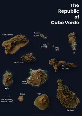
Adventures in relief shading, take two: The Republic of Cabo Verde. #blender #qgis #gis #srtm
🐦🔗: https://twitter.com/StrathSlater/status/1271064871950594050
Raf · @Raf
298 followers · 5913 posts · Server mastodon.socialRT @geo_spatialist@twitter.com
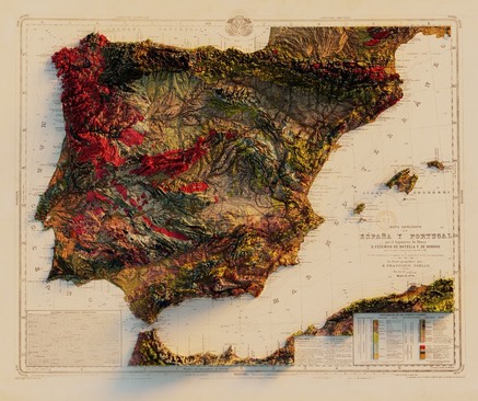
Mapa Geológico de España y Portugal - por el Ingeniero de Minas D. Federico de Botella y de Hornos - la parte geográfica por D. Francisco Coello - 1879
#arcgispro #blender #gis #maps #dataviz #datavisualization #copernicus #srtm
🐦🔗: https://twitter.com/geo_spatialist/status/1262064577807822848
#ArcGISPro #blender #gis #maps #dataviz #datavisualization #copernicus #srtm


