GregCocks · @GregCocks
609 followers · 553 posts · Server techhub.socialA New, Underground Atlas Of Subduction Zones [EOS]
--
https://eos.org/articles/a-new-underground-atlas-of-subduction-zones <-- shared technical article
--
https://submap.gm.umontpellier.fr/ <-- Submap, a tool for mapping subduction zones
--
“Graphic design meets geoscience…
Submap is a user-friendly tool that allows anyone with an Internet connection to create quick, custom maps of subduction zones…"
#GIS #spatial #mapping #visual #visualisation #visualization #subduction #geology #structuralgeology #Submap #geoscience #global #earth #platetectonics #subductionzones #earthquake #model #modeling #3dmapping #3dmodeling #opensource #opendata #tsunami #monitoring #fault #faulting #VisualizationTools #maps #crosssections
#gis #spatial #mapping #visual #visualisation #visualization #subduction #geology #structuralgeology #submap #geoscience #global #earth #platetectonics #subductionzones #earthquake #model #modeling #3dmapping #3dmodeling #opensource #opendata #tsunami #monitoring #fault #faulting #visualizationtools #Maps #crosssections
GregCocks · @GregCocks
598 followers · 535 posts · Server techhub.socialNew Geological Study Rewrites History Of The World's Highest Peaks
--
https://www.forbes.com/sites/davidbressan/2023/08/15/new-geological-study-rewrites-history-of-the-worlds-highest-peaks/ <-- shared media article
--
https://doi.org/10.1038/s41561-023-01243-x <-- shared paper
--
#GIS #spatial #mapping #remotesensing #uplift #Himalayas #tibet #model #modeling #research #uplift #sampling #hydrothermal #oxygenisotopes #India #Eurasia #mountains #geology #structuralgeology #TibetanPlateau #palaeoaltimetry #palaeoelevation #geodynamic #palaeoclimate #GangdeseArc #subduction #lithosphere #continentalcollision
#gis #spatial #mapping #remotesensing #uplift #himalayas #tibet #model #modeling #research #sampling #hydrothermal #oxygenisotopes #india #eurasia #mountains #geology #structuralgeology #tibetanplateau #palaeoaltimetry #palaeoelevation #geodynamic #palaeoclimate #gangdesearc #subduction #lithosphere #continentalcollision
GregCocks · @GregCocks
587 followers · 525 posts · Server techhub.socialFantastically Folded Rocks and the Beautiful Butte Fault - A Major Structure in the Grand Canyon
--
https://youtu.be/0yC5tc8KJoI <-- shared video
--
H/T Shawn Willsey
“Hike up scenic Carbon Canyon in the Grand Canyon with geology professor Shawn Willsey to investigate the sexy and magnificent rocks exposed along the Butte Fault. Learn how this fault formed, reversed its direction of movement, and made the East Kaibab Monocline…”
#GIS #spatial #mapping #geological #geologymapping #geologicmapping #fault #faulting #structuralgeology #fieldwork #model #modeling #CarbonCanyon #grandcanyon #USA #ButteFault
#gis #spatial #mapping #geological #geologymapping #geologicmapping #fault #faulting #structuralgeology #fieldwork #model #modeling #carboncanyon #grandcanyon #USA #buttefault
oldguy52 · @oldguy52
319 followers · 1143 posts · Server techhub.social#Monochrome
#BlackAndWhite
#LandscapePhotography
#PrinceOfWales
#WatertonLakesPark
This is the Prince of Wales in Waterton Park. This iconic structure was built in 1926 era. You come here for the views, for the #Wind (windiest place in #Alberta) and for the old railroad lodge experience. You also come for the #GlacialGeomorphology and #PrecambrianStratigraphy, and the #StructuralGeology. The POW is right next to the Mount Crandall #AntiformalDuplex. This and #EastGlacierLodge are highly recommended as a bucket list.
#monochrome #blackandwhite #landscapephotography #princeofwales #watertonlakespark #wind #alberta #glacialgeomorphology #precambrianstratigraphy #structuralgeology #antiformalduplex #eastglacierlodge
GregCocks · @GregCocks
420 followers · 452 posts · Server techhub.socialLong-Lost Remnants Of Ancient Continents Still Lurk Beneath Antarctica
--
https://www.iflscience.com/long-lost-remnants-of-ancient-continents-still-lurk-beneath-antarctica-69572 <-- shared technical article
--
https://doi.org/10.1038/s41598-018-34733-9 <-- shared paper
--
#GIS #spatial #mapping #remotesensing #satellite #GOCE #gravity #seismology #antarctica #cratons #lithosphere #continents #gravitygradients #model #modeling #tectonics #geology #structuralgeology #platetectonics #orogen #earthhistory #geologichistory
@ESA
#gis #spatial #mapping #remotesensing #satellite #goce #gravity #seismology #antarctica #cratons #lithosphere #continents #gravitygradients #model #modeling #tectonics #geology #structuralgeology #platetectonics #orogen #earthhistory #geologichistory
GregCocks · @GregCocks
297 followers · 387 posts · Server techhub.socialHow The Indian Ocean Geoid Low Was Formed
--
https://doi.org/10.1029/2022GL102694 <-- shared paper
--
#GIS #spatial #mapping #remotesensing #gravity #geoid #geodesy #IndianOcean #formation #IOGL #model #modeling #geophysics #structuralgeology #crustal #mantle #convection #Tethyan #sea #ocean #subsidence #anomaly #spatialanalysis #spatiotemporal #tomography #density #rock #geology #tectonics #platetectonics
#gis #spatial #mapping #remotesensing #gravity #geoid #Geodesy #indianocean #formation #iogl #model #modeling #geophysics #structuralgeology #crustal #mantle #Convection #tethyan #sea #ocean #subsidence #anomaly #spatialanalysis #spatiotemporal #tomography #density #rock #geology #tectonics #platetectonics
GregCocks · @GregCocks
297 followers · 386 posts · Server techhub.socialPost-Subduction Tectonics Induced By Extension From A Lithospheric Drip
--
https://doi.org/10.1038/s41561-023-01201-7 <-- shared paper
--
#GIS #spatial #mapping #formation #mechanical #data #geology #structuralgeology #platetectonics #subduction #tectonics #lithosphere #model #modeling #Borneo #magmatism #topography #uplift #Malysia #spatialanalysis #remotesensing #seismology #seismic #geophysics #gravity #gravational #volcanic #vulcanism #arc #simulation #simulations #crust #mantle #continent #orogeny
#gis #spatial #mapping #formation #mechanical #data #geology #structuralgeology #platetectonics #subduction #tectonics #lithosphere #model #modeling #borneo #magmatism #topography #uplift #malysia #spatialanalysis #remotesensing #seismology #seismic #geophysics #gravity #gravational #volcanic #vulcanism #arc #simulation #simulations #crust #mantle #continent #orogeny
Jorge 🇪🇺 🌍🛰️ · @lithospheric
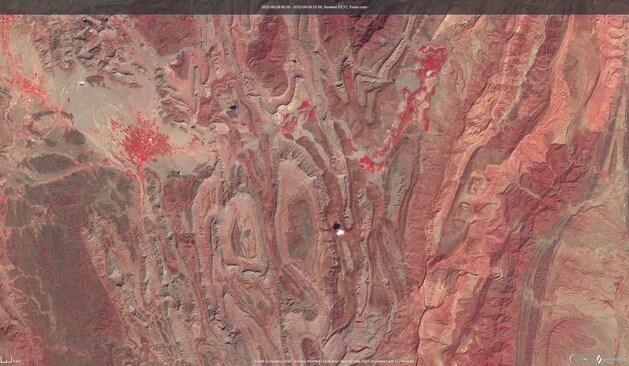
925 followers · 909 posts · Server mastodon.xyzGood morning. It's Friday. No, sorry... it's #FridayFold. Enjoy the superb anticlines and synclines in Baluchistan, Pakistan.
Infrared false-colour composite (looks predominantly red) over the Khude Range Fold Belt, Khuzdar Knot and Kirthar Range Fold Belt in #Pakistan.
Images processed in EO Browser, courtesy of Sentinel Hub. Contains Copernicus Sentine-2 data
#geology #remotesensing #earthobservation #sentinel2 #structuralgeology #Khude #Kirthar #Khuzdar
#fridayfold #pakistan #geology #remotesensing #earthobservation #sentinel2 #structuralgeology #khude #kirthar #khuzdar
GregCocks · @GregCocks
213 followers · 278 posts · Server techhub.socialScientists May Have Solved The Mystery Of How The Andes Got So Big
--
https://www.sciencealert.com/scientists-may-have-solved-the-mystery-of-how-the-andes-got-so-big <-- shared article
--
https://doi.org/10.1016/j.epsl.2023.118009 <-- shared paper
--
[although my postgrad was in geology and I am licensed in the field, it has been a number of years since I worked directly in a geologic discipline; that said, I very much like to try and keep up with ‘things geology’…]
#GIS #spatial #mapping #geology #southamerica #data #modeling #model #mathematics #mathematicalmodeling #structuralgeology #andes #chile #peru #platetectonics #tectonics #tectonic #movement #mountain #mountainbuilding #remotsensing #geologists #orogeny #vulcanism #pointers #APM #RPM
#gis #spatial #mapping #geology #SouthAmerica #data #modeling #model #mathematics #mathematicalmodeling #structuralgeology #andes #chile #Peru #platetectonics #tectonics #tectonic #movement #mountain #mountainbuilding #remotsensing #geologists #orogeny #vulcanism #pointers #apm #rpm
Jorge 🇪🇺 🌍🛰️ · @lithospheric
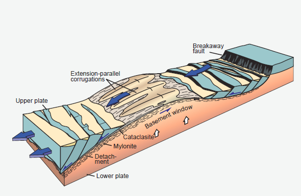
926 followers · 885 posts · Server mastodon.xyzI don't want you jealous, but I am mapping at work a metamorphic core complex, with satellite data.
#remotesensing #geology #tectonics #structuralgeology
GregCocks · @GregCocks
196 followers · 250 posts · Server techhub.socialGodzilla Gets a Forever Home on the Ocean Floor
--
https://eos.org/articles/godzilla-gets-a-forever-home-on-the-ocean-floor <-- shared article
--
#GIS #spatial #mapping #bathymetry #hydrospatial #marine #godzilla #pacificocean #japan #nautical #charts #GodzillaMegamullionProvince #ocean #seafloor #seabed #megamullion #midoceanridges #geology #tectonics #GodzillaMegamullion #oceaniccorecomplex #structuralgeology #survey
#gis #spatial #mapping #bathymetry #hydrospatial #marine #godzilla #pacificocean #Japan #nautical #charts #godzillamegamullionprovince #ocean #seafloor #seabed #megamullion #midoceanridges #geology #tectonics #godzillamegamullion #oceaniccorecomplex #structuralgeology #survey
GregCocks · @GregCocks
161 followers · 184 posts · Server techhub.socialDeconstructing Plate Tectonic Reconstructions
--
https://www.nature.com/articles/s43017-022-00384-8 <-- shared paper
--
#GIS #spatial #mapping #gischat #geology #structuralgeology #model #modeling #machinelearning #research #platetectonics #global #spatialanalysis #spatiotemporal #palaeomagnetics #reconstruction #software #opensource #community #SMEs #geophysics
#gis #spatial #mapping #gischat #geology #structuralgeology #model #modeling #machinelearning #research #platetectonics #global #spatialanalysis #spatiotemporal #palaeomagnetics #reconstruction #software #opensource #community #SMEs #geophysics
GregCocks · @GregCocks
150 followers · 169 posts · Server techhub.socialA Simplified GIS And Google-Earth-Based Approach For Lineaments And Terrain Attributes Mapping In A Basement Complex Terrain
--
https://doi.org/10.1038/s41598-022-20057-2 <-- shared paper
--
#GIS #spatial #mapping #imagery #geology #geologic #geological #geologymap #remotesensing #IdanreHills #Nigeria #Africa #spatialanalysis #structuralgeology #network #structural #imagery #lineaments #terrain #methodology #stream #hydrology #geomorphology #roughness #gischat #GoogleEarth #geologicmapping #batholith #gneiss #slope #flowlines #weathering #remotemapping #hillshade #raster
#gis #spatial #mapping #imagery #geology #geologic #geological #geologymap #remotesensing #idanrehills #nigeria #africa #spatialanalysis #structuralgeology #network #structural #lineaments #terrain #methodology #stream #hydrology #geomorphology #roughness #gischat #googleearth #geologicmapping #batholith #gneiss #slope #flowlines #weathering #remotemapping #hillshade #raster
GregCocks · @GregCocks
117 followers · 132 posts · Server techhub.socialThe GEM Global Active Faults Database [opendata]
--
https://doi.org/10.1177/8755293020944182 <-- shared paper
--
https://github.com/GEMScienceTools/gem-global-active-faults/blob/master/geopackage/gem_active_faults_harmonized.gpkg <-- global faults spatial database as a geopackage (~14k attributed polylines]
--
#GIS #spatial #mapping #data #opendata #database #fault #faults #global #geoscience #earthquakes #GEM #GAF #activefaults #geohazards #attributes #geology #structuralgeology #platetectonics
#gis #spatial #mapping #data #opendata #database #fault #faults #global #geoscience #earthquakes #gem #gaf #activefaults #geohazards #attributes #geology #structuralgeology #platetectonics
GregCocks · @GregCocks
101 followers · 113 posts · Server techhub.socialQuantitative Tectonic Geomorphic Study From Bedrock Rivers Of The Fold And Thrust Belt In The Bengal Basin
--
https://doi.org/10.1002/gj.4669 <-- shared paper
--
#GIS #spatial #modeling #mapping #spatialanalysis #geology #tectonics #geomorphology #BayOfBengal #BengalBasin #hydrology #rivers #people #risk #hazard #geomorphic #structuralgeology #india #bangladesh #platetectonics #remotesensing #DEM #elevation #bathymetry #topobathy #hydrospatial #uplift #fault #faulting #earthquakes #drainage #watersheds #basins #network
#gis #spatial #modeling #mapping #spatialanalysis #geology #tectonics #geomorphology #bayofbengal #bengalbasin #hydrology #rivers #people #risk #hazard #geomorphic #structuralgeology #india #Bangladesh #platetectonics #remotesensing #dem #elevation #bathymetry #topobathy #hydrospatial #uplift #fault #faulting #earthquakes #drainage #watersheds #basins #network
hypocentre · @hypocentre
227 followers · 2 posts · Server social.vivaldi.netRe-#introduction, this time on a new instance - now @hypocentre
Hello (again). I’m Dr Ian Stimpson, Senior Lecturer in #Geophysics at #KeeleUniversity, UK.
Background in #Geology & #Seismology, these days mostly involved with #Scicomm via http://tcs.ah-epos.eu
Research Interests:
#NearSurfaceGeophysics #Geoconservation #StructuralGeology & #ReservoirGeophysics plus the odd bit of #Python #GIS and #RemoteSensing.
Compiler of #Geotrails recorder of #Earthquakes and #Lidar scanner of pot banks.
#introduction #geophysics #keeleuniversity #geology #seismology #scicomm #nearsurfacegeophysics #geoconservation #structuralgeology #reservoirgeophysics #python #gis #remotesensing #geotrails #earthquakes #lidar
GregCocks · @GregCocks
89 followers · 98 posts · Server techhub.socialThe Eye Of The Sahara - A Geological Mystery Staring Into Space
--
https://www.iflscience.com/the-eye-of-the-sahara-a-geological-mystery-staring-into-space-67179 <-- shared article
--
https://doi.org/10.1016/j.jafrearsci.2014.04.006 <-- shared paper
--
https://doi.org/10.1007/s12517-021-08734-4 <-- shared paper
--
#GIS #spatial #mapping #remotesensing #satellite #Landsat #imagery #gischat #EyeOfTheSahara #vulcanism #intrusion #geology #Africa #RichatStructure #research #mauritania #structuralgeology #anticline #folding #sedimentary #igneous #formation #megabreccia #geologicalheritagesites
#gis #spatial #mapping #remotesensing #satellite #landsat #imagery #gischat #eyeofthesahara #vulcanism #intrusion #geology #africa #richatstructure #research #Mauritania #structuralgeology #anticline #folding #sedimentary #igneous #formation #megabreccia #geologicalheritagesites
GregCocks · @GregCocks
50 followers · 57 posts · Server techhub.social2022 - A Rock-Solid Year For Geology
--
https://cosmosmagazine.com/earth/earth-sciences/2022-rock-solid-geology/ <-- shared article
--
“2022 was a rockin’ good year for geology.
From mysteries deep within the Earth’s interior to a future supercontinent, here are five ways geology rocked our world this year…”
• Looking deep down into history
• Chicken and the egg: oxygen or photosynthesis?
• Reading the rocks to find the Best Australian Science Writing 2021
• Golden Spike to mark the Anthropocene
• A future supercontinent
#GIS #spatial #mapping #geology #research #science #interior #2022year #2022 #earth #structuralgeology #review #anthropocene #GoldenSpike #supercontinent #seismology #geophysics #ULVZ #oxygen #photosynthesis #hyperthermophilic #bacteria #Amasia #model #modeling #spatiotemporal
#gis #spatial #mapping #geology #research #science #interior #2022year #earth #structuralgeology #review #anthropocene #goldenspike #supercontinent #seismology #geophysics #ulvz #oxygen #photosynthesis #hyperthermophilic #bacteria #amasia #model #modeling #spatiotemporal
GregCocks · @GregCocks
2 followers · 11 posts · Server techhub.social3D Radargram Brings New Focus To Mars' North Polar Cap
--
https://phys.org/news/2022-11-3d-radargram-focus-mars-north.html <-- article
--
https://iopscience.iop.org/article/10.3847/PSJ/ac9d3b <-- paper
--
#GIS #spatial #mapping #model #modeling #Mars #remotesensing #satellite #SHARAD #geology #radar #MRO #radargrams #structuralgeology #sediment #geometry #water #research #science #interior
#gis #spatial #mapping #model #modeling #Mars #remotesensing #satellite #sharad #geology #radar #mro #radargrams #structuralgeology #sediment #geometry #water #research #science #interior
Dr Ian G Stimpson · @hypocentre
138 followers · 22 posts · Server mastodon.onlineRe-#introduction, this time with added hashtags
Hello (again). I’m Dr Ian Stimpson, Senior Lecturer in #Geophysics at #KeeleUniversity, UK.
Background in #Geology & #Seismology these days mostly involved with #Scicomm via http://tcs.ah-epos.eu (#InducedSeismicity).
Lecture in #NearSurfaceGeophysics #Geoconservation #StructuralGeology & #ReservoirGeophysics plus the odd bit of #Python #GIS and #RemoteSensing. Compiler of #Geotrails recorder of #Earthquakes and #Lidar scanner of pot banks.
#lidar #earthquakes #geotrails #RemoteSensing #GIS #python #reservoirgeophysics #structuralgeology #geoconservation #nearsurfacegeophysics #inducedseismicity #scicomm #seismology #geology #keeleuniversity #geophysics #introduction


